Historic detailed district maps
William Smith made this Official Information request to Far North District Council
This request has an unknown status. We're waiting for William Smith to read a recent response and update the status.
From: William Smith
Dear Far North District Council,
I have seen on several historic resource consent documents and applications dating from the 1980s and 90s excerpts from a hand drawn map showing the Kerikeri area in detail, including all property boundaries, deposited plan numbers and nearly every property seems to have a three digit number in a circle like "222" or where the property has been subdivided "220/1" and "220/2". Neighbouring properties often have consecutive numbers but these do not correspond to house numbers.
This seems to have been the main map used by the council for planning purposes for decades and it seems to have been changed and updated over the years but in each resource consent there is usually only a small excerpt from the map copied onto an A4 sheet. I can't find the whole map or any title or description of it.
Please could you:
a) Identify what this map is
b) Identify the purpose of the numbers in the circles
c) provide a scanned copy of the whole map, or at least the sheets relating to the Kerikeri area and particularly Riverview.
d) provide copies of all the different versions of that map which were used over the years.
Yours faithfully,
William Smith
From: Ask Us Team
Far North District Council
Thank you for reaching out to the Far North District Council.
We have received your message. A member of our customer service team will
issue a reference number for your enquiry within 5 working days.
If your matter is urgent, you can contact our Contact Centre at 0800 920
029, which operates 24 hours a day.
You can also find what you are looking for by visiting our website:
www.fndc.govt.nz
Kind regards
Ask Us Customer Services Team
--------------------------------------------
This is an automated reply
--------------------------------------------
From: William Smith
Dear Far North District Council,
Further to my previous email, here are some examples of the maps I'm talking about, one from the 1980s and one from about the late 90s:
https://i.postimg.cc/vZLnv26Y/Map-Sample...
https://i.postimg.cc/7hG7MxST/Map-Sample...
Yours faithfully,
William Smith
From: Ask Us Team
Far North District Council
Thank you for reaching out to the Far North District Council.
We have received your message. A member of our customer service team will
issue a reference number for your enquiry within 5 working days.
If your matter is urgent, you can contact our Contact Centre at 0800 920
029, which operates 24 hours a day.
You can also find what you are looking for by visiting our website:
www.fndc.govt.nz
Kind regards
Ask Us Customer Services Team
--------------------------------------------
This is an automated reply
--------------------------------------------
From: Ask Us Team
Far North District Council
Kia ora
Thank you for reaching out to the Far North District Council.
Your request has been forwarded to our Legal Services Team to action and
respond. Should you need to follow up on this matter, please use reference
number RFS- 4273276
If your matter is urgent, you can contact our Contact Centre at 0800 920
029, which operates 24 hours a day.
Nga mihi,
Zara
Ask Us Customer Services Team
From: Erica Cooney
Far North District Council
 image001.png
9K
Download
 image002.png
2K
Download
 image003.png
1K
Download
 image004.png
1K
Download
 image005.png
1K
Download
 image006.png
2K
Download
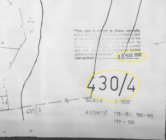 image007.png
174K
Download
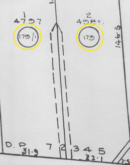 image008.png
67K
Download
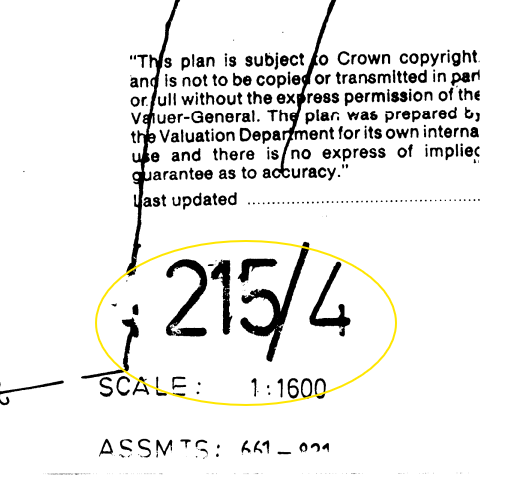 image009.png
75K
Download
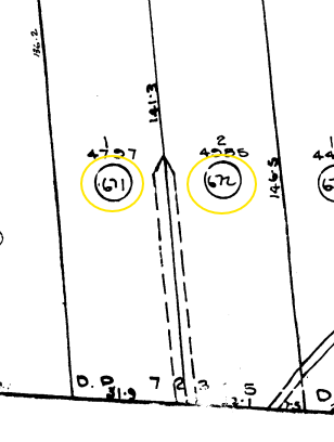 image010.png
31K
Download
![]() 1990 Val Map Riverview.pdf
1990 Val Map Riverview.pdf
10.7M
Download
View as HTML
![]() 1996 Val Map Riverview.pdf
1996 Val Map Riverview.pdf
599K
Download
View as HTML
Dear Requester
By Email Only: [1][FOI #32570 email]
Tēnā koe,
Official information request: 4273276
Thank you for your information request to the Far North District Council
(‘FNDC’) received on 14 October 2025. This request has been considered in
accordance with the provisions of the Local Government Official
Information and Meetings Act 1987 (the ‘LGOIMA’).
Your request
“I have seen on several historic resource consent documents and
applications dating from the 1980s and 90s excerpts from a hand drawn map
showing the Kerikeri area in detail, including all property boundaries,
deposited plan numbers and nearly every property seems to have a three
digit number in a circle like "222" or where the property has been
subdivided "220/1" and "220/2". Neighbouring properties often have
consecutive numbers but these do not correspond to house numbers.
This seems to have been the main map used by the council for planning
purposes for decades and it seems to have been changed and updated over
the years but in each resource consent there is usually only a small
excerpt from the map copied onto an A4 sheet. I can't find the whole map
or any title or description of it.
Please could you:
a) Identify what this map is
b) Identify the purpose of the numbers in the circles
c) provide a scanned copy of the whole map, or at least the sheets
relating to the Kerikeri area and particularly Riverview.
d) provide copies of all the different versions of that map which were
used over the years.”
FNDC’s response
FNDC’s responses are set out below alongside your respective queries:
Please could you:
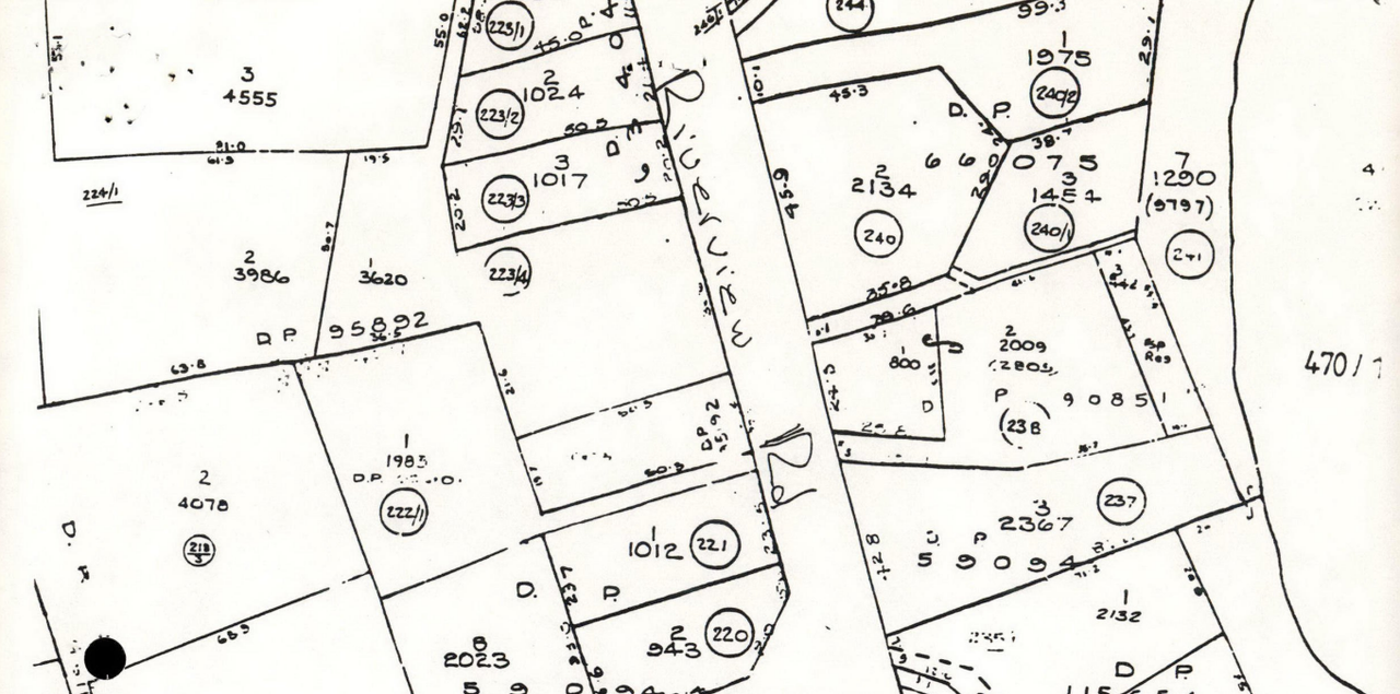
a) Identify what this map is – Old Valuation Roll Maps
b) Identify the purpose of the numbers in the circles – Numbers contained
in the circles are the Valuation assessment numbers
c) provide a scanned copy of the whole map, or at least the sheets
relating to the Kerikeri area and particularly Riverview. - Maps of
Riverview area attached.
d) provide copies of all the different versions of that map which were
used over the years. See below
Valuation Roll Maps
2 sets of roll maps held on record for the district.
Pre-1996 (old assessment/valuation roll numbers)
Drawing No. 430/4 – dated 08-Mar-1990 Riverview area (Snip 1 below)
430 – Roll number for the area (Kerikeri)
4 – Sheet number in the volume
Numbers within circles – Assessment number allocated to each property
(Snip 2 below)
Full plan attached titled – 1990 Val Map Riverview
Converting the example below – the Valuation roll number in 1990 would
translate to: 00430-17900 and 00430-17901
Snip 1
Snip
2
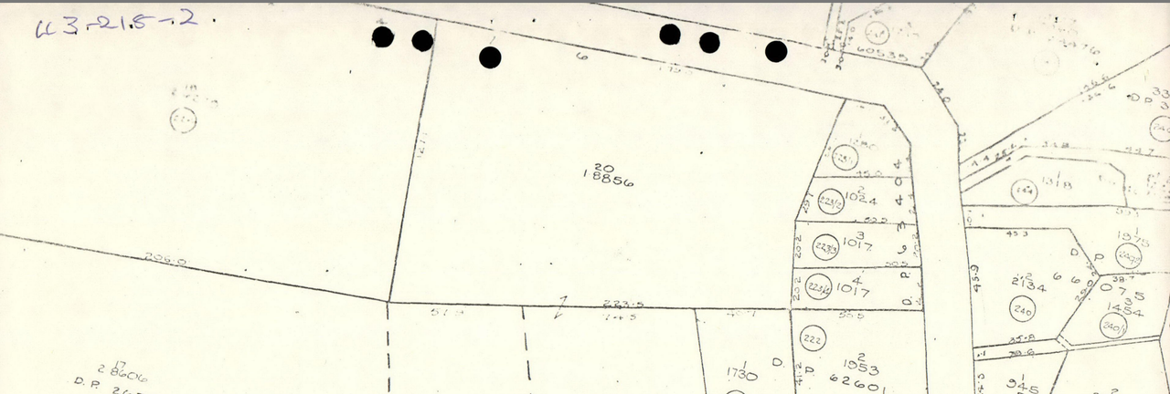
Post-1996 (current assessment/valuation roll numbers)
New valuation numbers and revised maps were rolled out around 1995-1996.
New roll and assessment numbers were allocated.
Drawing No. 215/4 – Riverview area (Snip 3 below)
215 – Roll number for the area (Kerikeri)
4 – Sheet number in the volume
Numbers within circles – New assessment number allocated to each property
(Snip 4 below)
Full plan attached titled – 1996 Val Map Riverview
Converting the example below – the Valuation roll number from 1996 -
current: 00215-67100 and 00215-67200
Snip
3
Snip
4
Thank you for your enquiry. If you have further questions, please feel
free to contact us.
Nāku noa,
Te Kaunihera o Te Hiku o te Ika | Far
North District Council
----------------------------------------
Pokapū Kōrero 24-hāora | 24-hour
Contact Centre 0800 920 029
[2][IMG] [3][IMG][4] [5][IMG][6]
[7][IMG][8] [9][IMG]
References
Visible links
1. mailto:[FOI #32570 email]
2. https://www.fndc.govt.nz/home
3. https://www.facebook.com/FarNorthDistric...
4. FNDC Facebook
https://www.facebook.com/FarNorthDistric...
5. https://nz.linkedin.com/company/far-nort...
6. FNDC LinkedIn
https://nz.linkedin.com/company/far-nort...
7. https://www.youtube.com/channel/UCRbGkKa...
8. FNDC YouTube channel
https://www.youtube.com/channel/UCRbGkKa...
9. https://www.instagram.com/farnorth_dc/
From: William Smith
Dear Ms Cooney,
Thanks for your reply, which partially answers my request, however some information is missing:
1. The bottom of the 1996 map is cropped off. Please could you supply the complete map with the whole title and labels visible.
2. You have only supplied maps for 1990 and 1996. I requested all editions of this map. Please could you supply copies of all other editions of this map showing the same or similar area from earlier or later dates.
Yours sincerely,
William Smith
From: William Smith
Dear Erica Cooney,
Further to my earlier message:
3. I note that you have only supplied the sheet pertaining to the Riverview area. I don't need any other map sheets but please could you include any front cover, title page, key to symbols or other information pages which provide information describing this map.
Yours sincerely,
William Smith
From: Erica Cooney
Far North District Council
 image001.png
9K
Download
 image002.png
2K
Download
 image003.png
1K
Download
 image004.png
1K
Download
 image005.png
1K
Download
 image006.png
2K
Download
![]() 1990 Val Map Riverview.pdf
1990 Val Map Riverview.pdf
10.7M
Download
View as HTML
![]() 1996 Val Map Riverview.pdf
1996 Val Map Riverview.pdf
599K
Download
View as HTML
Dear Requester
By Email Only: [1][FOI #32570 email]
Tēnā koe,
Official information request: 4273276
We refer to Far North District Council (FNDC) response of 12 November 2025
and to your follow-up queries set out below:
Thanks for your reply, which partially answers my request, however some
information is missing:
1. The bottom of the 1996 map is cropped off. Please could you supply the
complete map with the whole title and labels visible.
2. You have only supplied maps for 1990 and 1996. I requested all editions
of this map. Please could you supply copies of all other editions of this
map showing the same or similar area from earlier or later dates.
3. I note that you have only supplied the sheet pertaining to the
Riverview area. I don't need any other map sheets but please could you
include any front cover, title page, key to symbols or other information
pages which provide information describing this map.
This request has been considered in accordance with the provisions of the
Local Government Official Information and Meetings Act 1987 (the LGOIMA).
It is noted that the relevant maps are historic, dating back to the
1990’s.
1. In respect of the 1996 map (attached above), other than what has
already been provided to you, FNDC does not hold any further information.
That is, it does not have a copy of ”the complete map with the whole title
and labels visible”. Given this, FNDC refuses this part of your request
for administrative reasons. FNDC relies upon section 17(e) of the LGOIMA.
That is, “that the document[s] alleged to contain the information
requested does not exist or, despite reasonable efforts to locate it,
cannot be found”.
2. Other than the maps already provided to you (attached), FNDC does not
hold any other editions. Therefore, in respect of Q2., for the same
reasons as above, FNDC refuses this part of your request under section
17(e) of the LGOIMA.
3. The map provided to you related to the Riverview area to which your
request referred. Please refer to FNDC’s response to Q1. above. Again, as
FNDC does not hold the information sought in Q3. this part of your request
is also refused in reliance on s17(e).
You have the right to seek a review of this decision by the Ombudsman if
you so choose. Information about how to make a complaint is available at
[2]www.ombudsman.parliament.nz or Freephone 0800 802 602
We are sorry that we are unable to assist you further, however it may be
that Archives New Zealand can help you with your queries.
Nāku noa, nā
Te Kaunihera o Te Hiku o te Ika | Far
North District Council
----------------------------------------
Pokap K��o 24-h⯲a | 24-hour Contact
Centre 0800 920 029
[3][IMG] [4][IMG][5] [6][IMG][7]
[8][IMG][9] [10][IMG]
References
Visible links
1. mailto:[FOI #32570 email]
2. http://www.ombudsman.parliament.nz/
3. https://www.fndc.govt.nz/home
4. https://www.facebook.com/FarNorthDistric...
5. FNDC Facebook
https://www.facebook.com/FarNorthDistric...
6. https://nz.linkedin.com/company/far-nort...
7. FNDC LinkedIn
https://nz.linkedin.com/company/far-nort...
8. https://www.youtube.com/channel/UCRbGkKa...
9. FNDC YouTube channel
https://www.youtube.com/channel/UCRbGkKa...
10. https://www.instagram.com/farnorth_dc/
Things to do with this request
- Add an annotation (to help the requester or others)
- Download a zip file of all correspondence (note: this contains the same information already available above).

Offensive? Unsuitable?
Requests for personal information and vexatious requests are not considered valid requests for Official Information (read more).
If you believe this request is not suitable, you can report it for attention by the site administrators
Report this request