Apparent boundary discrepancies - Funding Impact Statement (Rating Tools) – Appendix Maps
Charles Barclay made this Official Information request to Kaipara District Council
This request has an unknown status. We're waiting for Charles Barclay to read recent responses and update the status.
From: Charles Barclay
06 February 2022, Te Kopuru.
To Kaipara District Council
Local Government Official Information and Meetings Act 1987
Apparent boundary discrepancies - Funding Impact Statement (Rating Tools) – Appendix Maps
I have been unable to make sense of the above matter from public available web and paper sources.
Please may I be furnished with the following information.
A single scaled, layered overlay of the legally operative, current f.y.e Impact Statement “esri-shapefiles” actually used in printing the published & binding paper document currently operative for the following:
Kopuru Swamp Drainage District
Tatariki No1 Drainage District
Te Kopuru Stormwater
Hightinghting & separately listing, all property parcels which feature (a) IN MORE THAN ONE of the above three layers. (b) which DO NOT FEATURE in any of the three layers but fall within the area circumscribed by the three districts and it’s hydro-parcel bounds. And (c) Any parcel surface area TRANSECTED by a district boundary, SUCH THAT part of the parcel lies within one district and part in another or no other. (There are I believe at least two instances of this.)
For your guidance, I attach the 3 simple paper published areas concerned as far as I can determine & a detail of the area of interest.
Charles Barclay.
P.O. Box 211, Dargaville.
(p.s. It appears fyi.org.nz no longer support graphic attachments; I will forward this by email forthwith)
From: Council
Kaipara District Council
Kia ora Charles
Thank you for your request for information which will be treated under the Local Government Official Information and Meetings Act 1987. Pursuant to the Act you will receive a response within 20 working days. Your response is due no later than 08 March 2022.
Detailed information regarding official information requests can be found on our website here.
If you require any further assistance please contact the Kaipara District Council email [Kaipara District Council request email], telephone 0800 727 059 or visit our website www.kaipara.govt.nz
Ngā mihi
Kevin Whitehead | Kaitiaki Kiritaki | Customer Support Advisor
Kaipara te Oranganui | Kaipara District Council, Private Bag 1001, Dargaville 0340
Freephone: 0800 727 059 | 0800 105 890
[Kaipara District Council request email] | www.kaipara.govt.nz
Dargaville Office: 42 Hokianga Road, Dargaville 0310
Mangawhai Office: Unit 6, The Hub, 6 Molesworth Drive, Mangawhai 0505
Opening Hours: Monday, Tuesday, Thursday, Friday 8am to 4.30pm and Wednesday 9am to 4.30pm.
show quoted sections
From: Administration Requests
Kaipara District Council

Hello Mr Barclay
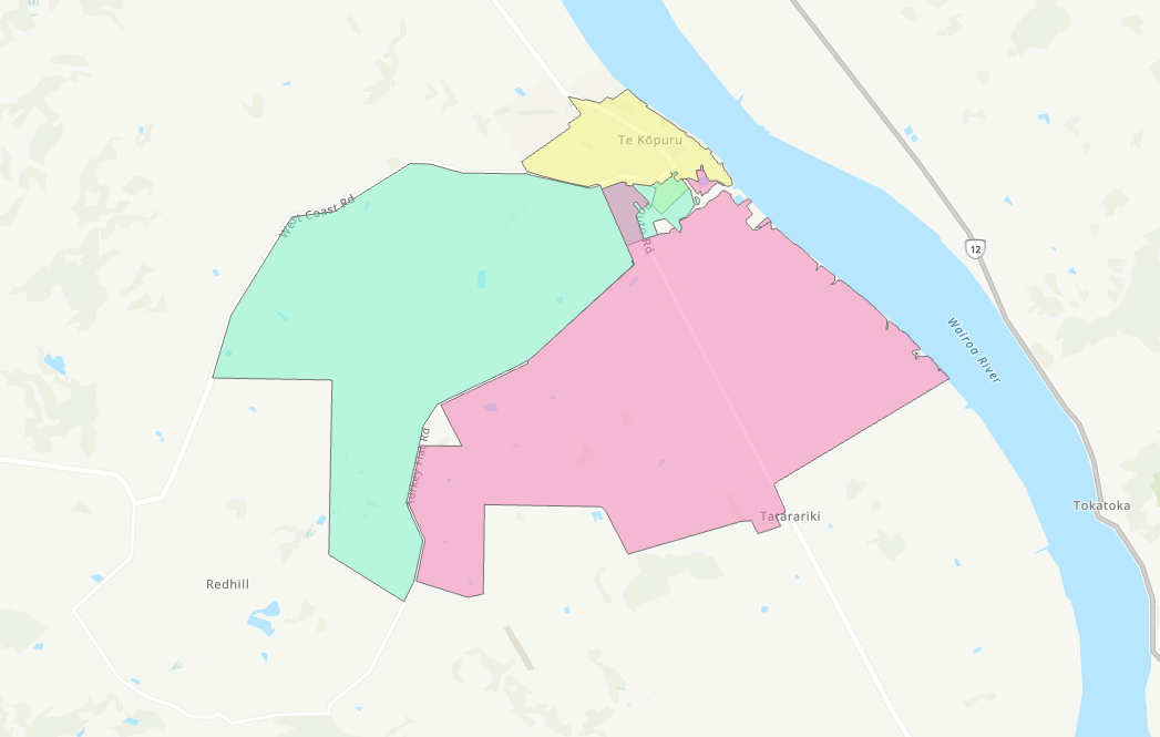
Thank you for your request for information relating to ersi shapefiles for
the Kopuru Swamp Drainage District, Tatariki No1 Drainage District and the
TK Stormwater under the Local Government Official Information and Meetings
Act 1987 (LGOIMA). Please see the attached shapefile containing the three
targeted rating areas that have been requested and below is an overlay of
the districts.
These shapes are from the original 2015 Long Term Plan mapping and are
indicative maps only. In the 2021 Long Term Plan, Council stated on page
86
“Indicative maps of the areas of the respective land drainage schemes can
be viewed in the Appendix - Maps (pages 109 to 123) of this document.
Please contact the Council if you would like confirmation whether a
property is within the rating area or not”.
In relation to your questions a, b and c, Council does not hold this
information. As such under section 17(g) of the LGOIMA answering these
requests in full is refused as it would require staff to analyse the data
and form a conclusion.
Regards Linda
[1]KDC Logo Linda Osborne | Administration Manager
test June 2015
Kaipara District Council, Private Bag 1001, Dargaville 0340
Freephone: 0800 727 059 | 09 439 3123
[2][Kaipara District Council request email] | [3]www.kaipara.govt.nz
From: Kaipara District Council <[4][email address]>
Sent: Tuesday, 8 February 2022 11:46 AM
To: Administration Requests <[5][email address]>
Subject: LGOIMA REQUEST - Official Information request - Apparent boundary
discrepancies - Funding Impact Statement (Rating Tools) – Appendix Maps
CAUTION: This email originated from outside Kaipara District Council. Do
not click links or open attachments unless you recognise the sender and
know the content is safe.
Kia ora team
This LGOIMA request has been received in the Council inbox and forwarded
to you for action and reply. Customer has been advised a response is due
by 08/03/22
Ngâ mihi
Kevin
From: [6][FOI #18468 email]
Sent: Sunday, February 6, 2022 3:06 PM
To: [7][email address]
Subject: Official Information request - Apparent boundary discrepancies -
Funding Impact Statement (Rating Tools) – Appendix Maps
--------------------------------------------------------------------------
CAUTION: This email originated from outside Kaipara District Council. Do
not click links or open attachments unless you recognise the sender and
know the content is safe.
06 February 2022, Te Kopuru.
To Kaipara District Council
Local Government Official Information and Meetings Act 1987
Apparent boundary discrepancies - Funding Impact Statement (Rating Tools)
– Appendix Maps
I have been unable to make sense of the above matter from public available
web and paper sources.
Please may I be furnished with the following information.
A single scaled, layered overlay of the legally operative, current f.y.e
Impact Statement “esri-shapefiles” actually used in printing the published
& binding paper document currently operative for the following:
Kopuru Swamp Drainage District
Tatariki No1 Drainage District
Te Kopuru Stormwater
Hightinghting & separately listing, all property parcels which feature (a)
IN MORE THAN ONE of the above three layers. (b) which DO NOT FEATURE in
any of the three layers but fall within the area circumscribed by the
three districts and it’s hydro-parcel bounds. And (c) Any parcel surface
area TRANSECTED by a district boundary, SUCH THAT part of the parcel lies
within one district and part in another or no other. (There are I believe
at least two instances of this.)
For your guidance, I attach the 3 simple paper published areas concerned
as far as I can determine & a detail of the area of interest.
Charles Barclay.
P.O. Box 211, Dargaville.
(p.s. It appears fyi.org.nz no longer support graphic attachments; I will
forward this by email forthwith)
-------------------------------------------------------------------
This is an Official Information request made via the FYI website.
Please use this email address for all replies to this request:
[8][FOI #18468 email]
Is [9][Kaipara District Council request email] the wrong address for Official Information
requests to Kaipara District Council? If so, please contact us using this
form:
[10]https://fyi.org.nz/change_request/new?bo...
Disclaimer: This message and any reply that you make will be published on
the internet. Our privacy and copyright policies:
[11]https://fyi.org.nz/help/officers
If you find this service useful as an Official Information officer, please
ask your web manager to link to us from your organisation's OIA or LGOIMA
page.
-------------------------------------------------------------------
References
Visible links
1. http://www.kaipara.govt.nz/
2. mailto:[Kaipara District Council request email]
3. http://www.kaipara.govt.nz/
4. mailto:[email address]
5. mailto:[email address]
6. mailto:[FOI #18468 email]
7. mailto:[email address]
8. mailto:[FOI #18468 email]
9. mailto:[Kaipara District Council request email]
10. https://fyi.org.nz/change_request/new?bo...
11. https://fyi.org.nz/help/officers
From: Charles Barclay
07 March 2022, Te Kopuru.
To Kaipara District Council
Local Government Official Information and Meetings Act 1987
Apparent boundary discrepancies - Funding Impact Statement (Rating Tools) – Appendix Maps [#02]
I acknowledge your reply of 04MAR22 but believe you to be either misinformed yourself or asserting misinformation to me, in saying…. <<Council does not hold this information. >>. KDC now holds both the three drainage area polygons AND the linz property parcel layer (KDC’s own authored Kaipara sub-set - see attached) on the current gis-system. Overlaying them Is straightforward. I do not have access to gis-enabled systems, so please supply as image file of sufficient scale/resolution to clearly discriminate parcel_id, small urban parcels and narrow access ways. My original request stands and is reiterated herein.
In the meantime, to save endless LGOIMA monthly reply cycles, the attached file shows a crudely made graphical image overlay of a small sub-section of the full area in question. From this it is patently obvious that (to eye only; not exhaustive) a number of parcels fall into my three originally requested categories:
Category NZ Primary Parcel ID’s
(a) Ambiguous 4876782 / 5133828 / 7546904 / 7546880 / 4905163 part
(b) Exceptional 5053783 / 4824230 major-part / 4755961 major-part
(c) Contradictory 4905163 / 4824230 / 4755961
The above adjectives are inappropriate for a public domain, open, equitable and transparent rating database or representation of such. May I therefore further request now, to which drainage rate the above parcels are subject, and if none, the legal, bye law or regulatory basis of that exception? (Per your “Please contact the Council if you would like confirmation whether a property is within the rating area or not”)
Charles Barclay
P.O. Box 211, Dargaville.
From: Administration Requests
Kaipara District Council


Hi Mr Barclay
You have mentioned attachments. There was nothing attached, please can
you send them through.
Regards Linda
[1]KDC Logo Linda Osborne | Administration Manager
test June 2015
Kaipara District Council, Private Bag 1001, Dargaville 0340
Freephone: 0800 727 059 | 09 439 3123
[2][Kaipara District Council request email] | [3]www.kaipara.govt.nz
From: Kaipara District Council <[email address]>
Sent: Thursday, 10 March 2022 7:30 AM
To: Administration Requests <[email address]>
Subject: LGOIMA Request ATTN Linda: ID019216 - Apparent boundary
discrepancies - Funding Impact Statement (Rating Tools) – Appendix Maps
[#02] - Addendum to previously submitted fyi.org.nz / LGOIMA request
CAUTION: This email originated from outside Kaipara District Council. Do
not click links or open attachments unless you recognise the sender and
know the content is safe.
Kia ora Linda
This correspondence has been received in the Council inbox and forwarded
to you for your reference and a response.
Regards
Kevin
From: [email address]
Sent: Wednesday, March 9, 2022 7:17 AM
To: [email address]
Subject: Re: ID019216 - Apparent boundary discrepancies - Funding Impact
Statement (Rating Tools) – Appendix Maps [#02] - Addendum to previously
submitted fyi.org.nz / LGOIMA request
--------------------------------------------------------------------------
CAUTION: This email originated from outside Kaipara District Council. Do
not click links or open attachments unless you recognise the sender and
know the content is safe.
Kevin,
Needs to go to Lynda Osborne, I guess…. Formally “
Administration Requests
Kaipara District Council
I have just confirmed my follow-up request of 07MAR22 via fyi.org.nz is
showing and in-situ on their system; in case it has somehow failed to
transmit/alert to your system, I (informally) copy the content below.
Rgds Charles.
07 March 2022, Te Kopuru.
To Kaipara District Council
Local Government Official Information and Meetings Act 1987
Apparent boundary discrepancies - Funding Impact Statement (Rating Tools)
– Appendix Maps [#02]
I acknowledge your reply of 04MAR22 but believe you to be either
misinformed yourself or asserting misinformation to me, in saying….
<<Council does not hold this information. >>. KDC now holds both the three
drainage area polygons AND the linz property parcel
layer (KDC’s own authored Kaipara sub-set - see attached) on the current
gis-system. Overlaying them Is straightforward. I do not have access to
gis-enabled systems, so please supply as image file of sufficient
scale/resolution to clearly discriminate parcel_id,
small urban parcels and narrow access ways. My original request stands and
is reiterated herein.
In the meantime, to save endless LGOIMA monthly reply cycles, the attached
file shows a crudely made graphical image overlay of a small sub-section
of the full area in question. From this it is patently obvious that (to
eye only; not exhaustive) a number of
parcels fall into my three originally requested categories:
Category NZ Primary Parcel ID’s
(a) Ambiguous 4876782 / 5133828 / 7546904
/ 7546880 / 4905163 part
(b) Exceptional 5053783 / 4824230 major-part / 4755961 major-part
(c) Contradictory 4905163 / 4824230 / 4755961
The above adjectives are inappropriate for a public domain, open,
equitable and transparent rating database or representation of such. May I
therefore further request now, to which drainage rate the above parcels
are subject, and if none, the legal, bye law
or regulatory basis of that exception? (Per your “Please contact the
Council if you would like confirmation whether a property is within the
rating area or not”)
Charles Barclay
P.O. Box 211, Dargaville.
Sent from my iPad. If urgent Txt +64 22 439 5828. Infrequent eMail
Pickup.
show quoted sections
From: Charles Barclay
To Kaipara District Council
Local Government Official Information and Meetings Act 1987
Apparent boundary discrepancies - Funding Impact Statement (Rating Tools)
– Appendix Maps [#02]
Ms Osborne,
I have yet to receive KDC’s standard acknowlegement and “reply due (20 work days) date, regarding the above subject information request dated 07MAR22.
Please confirm you are in receipt of the graphic attachment first sent 07MAR22 to [email address] and resent to you personally as [email address] on the 18MAR22 and the date by which reply may be expected.
Charles Barclay
P.O. Box 211, Dargaville.
From: Administration Requests
Kaipara District Council
Hello Mr Barclay
In our recent telephone conversation we discussed this request so I wasn’t aware you required an acknowledgement. I can confirm I received the attachment.
Our GIS specialist is trying to figure out data that will make sense for you and ensure your request is answered. He is still unsure if he can. Your response is due by 4 April 2022.
Regards Linda
Linda Osborne | Administration Manager
Kaipara District Council, Private Bag 1001, Dargaville 0340
Freephone: 0800 727 059 | 09 439 3123
[Kaipara District Council request email] | www.kaipara.govt.nz
show quoted sections
From: Administration Requests
Kaipara District Council
Hello Mr Barclay
Further to your request for information relating to the drainage district
boundaries.
The drainage district boundaries are very historical and we understand
there are discrepancies with them. While we can almost confidently map
those properties that are paying a targeted rate we cannot accurately map
all of the corresponding drainage districts, including those you were
requesting. Hence our disclaimer asking ratepayers to contact us
regarding specific property information. Our GIS specialist has spent
some time trying to figure out a way to do this but he, nor anybody else
at Council, has the necessary information to give a complete picture. He
has advised it is would be a significant project to do this. We so
realise this needs to be reviewed in the future therefore as part of the
2023 Long Term Plan it is our intention to review all of the drainage
district maps.
As mentioned in my previous response we are not able to provide the map
overlays you are requesting.
However, my understanding is you are interested in specific properties.
If you can provide queries about a property, for example if should be or
shouldn’t be paying a drainage rate, or whether it is paying two drainage
rates we would be happy to provide further individual information. If you
can use a valuation number to identify the property that will make it
simpler for us to find. Compatibility with our GIS and rating software is
far easier to search using valuation numbers rather than parcel ID's.
Regards Linda
Linda Osborne | Administration Manager
Kaipara District Council, Private Bag 1001, Dargaville 0340
Freephone: 0800 727 059 | 09 439 3123
[1][Kaipara District Council request email] | [2]www.kaipara.govt.nz
show quoted sections
From: Administration Requests
Kaipara District Council

Hello again Mr Barclay
I have just heard back from our GIS specialist. While he cannot create a
map he has investigated the properties you have identified managing to use
the parcel ID’s. Below is a table with the results.
LGOIMA Request KDC Property Information
Valuation
Parcel ID Category Number Targeted Rate Area
Korpuru Swamp
4876782 Ambiguous 109019800 Drainage District
Korpuru Swamp
5133828 Ambiguous 111001900 Drainage District
Korpuru Swamp
7546904 Ambiguous 111001500 Drainage District
Te Kopuru
7546880 Ambiguous 111005100 Stormwater
Ambiguous / Tatariki 1 Drainage
4905163 part Contradictory 109016600 District
5053783 Exceptional 109016100 N/A
4824230 Exceptional /
major-part Contradictory 109017005 N/A
4755961 Exceptional / Tatariki 1 Drainage
major-part Contradictory 109016801 District
The two with an 'N/A' are not currently contributing to any targeted rate
area, but appear that they should be. They should become part of Korpuru
Swamp Drainage District. Council will be adding the drainage rates for
next year to the 3 properties at the end of the table and communicating
with the ratepayers. Thank you for bringing this to our attention.
Regards Linda
[1]KDC Logo Linda Osborne | Administration Manager
test June 2015
Kaipara District Council, Private Bag 1001, Dargaville 0340
Freephone: 0800 727 059 | 09 439 3123
[2][Kaipara District Council request email] | [3]www.kaipara.govt.nz
show quoted sections
Things to do with this request
- Add an annotation (to help the requester or others)
- Download a zip file of all correspondence (note: this contains the same information already available above).

Offensive? Unsuitable?
Requests for personal information and vexatious requests are not considered valid requests for Official Information (read more).
If you believe this request is not suitable, you can report it for attention by the site administrators
Report this request