District Pan GIS data
Craig Innes made this Official Information request to Whangarei District Council
The request was successful.
From: Craig Innes
Tena koe,
This is a request for information under the Local Government Official Information and Meetings Act 1987.
Please supply all GIS data relating to sites and areas of significance to Maori as well as papakainga for the District Plan.
Naku noa, na,
Craig Innes.
Whangarei District Council

Tēnā koe,
Thank you for contacting us. Your request has been logged under the Local
Government Official Information and Meetings Act 1987.
We will respond to your request as soon as possible and in any case no
later than within 20 working days.
You can also call us freephone 0800 932 463. Please quote Request No.
OIA230964 if you require any further information.
If you would like to notify us about anything further regarding this
matter, you can reply to this email.
Ngā mihi,
Whangarei District Council
--EmailIdentifier---eyJJSWQiOiJkYTI2MWIzYS02ZTY4LTRjZDEtODcyNi1hYTZkODM2NTNlNTYiLCJIIjoiISFIQWVDZ1lqK3RHZG5KTCtGR2FVSDFZIn0=---EmailIdentifier--
From: Yvonne Masefield
Whangarei District Council
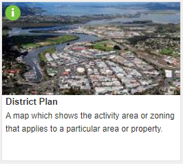 image002.png
71K
Download
 image003.png
2K
Download
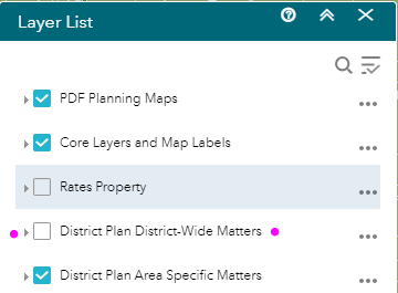 image004.png
12K
Download
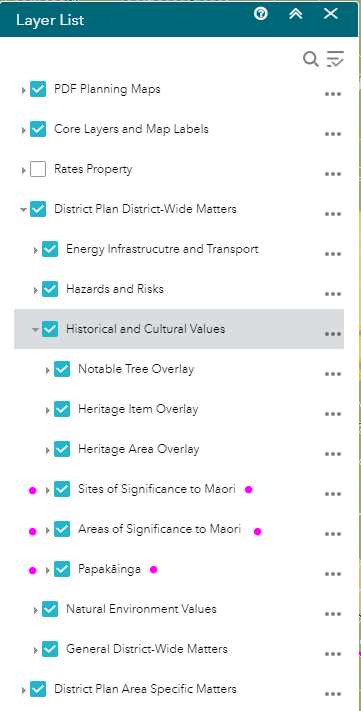 image005.png
32K
Download
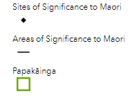 image006.png
3K
Download
 image007.png
13K
Download
Tēnā koe Mr Innes,
I refer to your request of 1 October 2023 for all GIS data relating to
sites and areas of significance to Māori as well as Papakāinga for the
District Plan.
Your request was referred to council’s District Planning and ICT
Departments for consideration.
The GIS data you have asked for can be accessed using the instructions
below. There are two options, as follows:
A. The District Plan map in GIS Maps public viewer
1 Open Gallery at [1]https://gismaps.wdc.govt.nz/GISMapsGalle...
2 Open the District Plan map.
Read and select OK for the Online Mapping conditions of Use
disclaimer.
3 Open the Layer List from the top tool bar.
4 Turn on District Plan District-Wide Matters layer group.
5 Within this group is where the layers requested are found.
6 The symbology for layers requested is as shown here (snipped
from the Legend tool)
7 Turn off District Plan Area Specific Matters layer group if desired to
reduce layers/information for a clearer view.
B. Rest Services for GIS desktop application users.
Advanced users who use GIS desktop applications such as ArcMap or ArcPro
will know how to use published rest services to upload the map image into
their own desktop application.
Access the requested layers here:
[2]https://geo.wdc.govt.nz/server/rest/serv...
I hope this information is of some assistance in responding to your
request. If you believe we have not responded appropriately to your
request, you have the right by way of complaint, under section 27(3) of
the Act, to apply to the Ombudsman to seek an investigation and review of
the decision.
Ngā mihi
Yvonne Masefield
Manager | District Plan Department
Whangarei District Council | Te Iwitahi, 9 Rust Avenue | Private Bag 9023,
Te Mai, Whangārei 0143
P 09 430 4200 | M 021 196 5685 | [3]www.wdc.govt.nz
Please note my normal working hours are 7.30am to 3:30pm Monday, 7:30am to
2.30pm Tuesday, 8.30am to 2.30pm Wednesday and 8.30am to 4.30pm Thursday.
I only work Friday on an as needs basis, scheduled in advance.
show quoted sections
Things to do with this request
- Add an annotation (to help the requester or others)
- Download a zip file of all correspondence (note: this contains the same information already available above).

Offensive? Unsuitable?
Requests for personal information and vexatious requests are not considered valid requests for Official Information (read more).
If you believe this request is not suitable, you can report it for attention by the site administrators
Report this requestAct on what you've learnt
Similar requests
Investigation of Mill Rd Spraying Incident of Oct 2021 initiated by NTA manager Calvin Thomas WDC
To Whangarei District Council by Northland Toxin Awareness Group