Review of Proposed Post-Quake
Bus Network
Environment Canterbury
Report
August 2012
11706 20120823-review of proposed post quake bus network.rep


Review of Proposed Post-Quake Bus
Network
Environment Canterbury
Report
Quality Assurance Statement
Prepared by:
Russell Turnbull
National Specialist – Public
Transport
Reviewed by:
Julie Ballantyne
Christchurch Branch Manager
Approved for Issue by:
Julie Ballantyne
Christchurch Branch Manager
Status:
Final (version 2) report
Date:
23 August 2012
PO Box 8615, Riccarton
Christchurch
New Zealand
P: +64 3 348 3215
www.tdg.co.nz
11706 20120823-Review of Proposed Post Quake Bus Network.rep
Table of Contents
1.
Executive Summary ................................................................................................................ 1
2.
Background ............................................................................................................................. 2
3.
Review Process ...................................................................................................................... 3
3.1
Assess Land Use Change ......................................................................................... 3
3.2
Apply the Christchurch Transportation Model (CTM) ................................................. 3
3.3
Qualitative Review ..................................................................................................... 3
4.
Land Use Change ................................................................................................................... 4
4.1
Context ...................................................................................................................... 4
4.2
Change in Land Use .................................................................................................. 4
5.
Travel Demands ...................................................................................................................... 6
5.1
Very High Travel Demands ....................................................................................... 7
5.2
High Travel Demands ................................................................................................ 9
6.
Key Employment Zones ........................................................................................................ 11
6.1
Fit to Proposed Bus Network ................................................................................... 13
7.
Recommendations for Further Investigation ......................................................................... 14
7.1
Middleton / Hoon Hay to Riccarton / Ilam ................................................................ 14
7.2
Roydvale Ave Interchange & Route 3 Diversion ...................................................... 14
7.3
Bishopdale to St Albans / Merivale .......................................................................... 14
7.4
Somerfield/Sydenham to Riccarton / Ilam ............................................................... 14
7.5
Halswell to Riccarton / Ilam ..................................................................................... 14
Review of Proposed Post-Quake Bus Network, Environment Canterbury: Report
11706 20120823-Review of Proposed Post Quake Bus Network.rep
1
1.
Executive Summary
Traffic Design Group (TDG) was commissioned by Environment Canterbury (ECan) to assess its
proposed new Christchurch bus network for its fit to post 2011 earthquake employment needs of
the city.
The new bus network has been designed on a ‘hub and spoke’ system; a set of core routes
connecting CBD and suburban interchanges with connector and link services feeding the
interchanges.
Our assessment of the fit of the network to employment travel needs has used two approaches.
Firstly, we have assessed the delivery of the network to meeting the overall travel demands (all
travel purposes irrespective of mode) as estimated by the Christchurch Transportation Model
(CTM), which includes the post-2011 quake land use.
Secondly, we have looked at the key employment zones in Christchurch, post the 2011 quake,
and assessed the delivery of the proposed bus network against the geographic location of each
zone.
Our assessment using the CTM looked at the “very high” and “high” transport demands
generated by the model to assess the fit of the proposed network. We classified ‘Very High’
demand as journeys between sectors greater than 20,000 persons per weekday (irrespective of
mode or travel purpose). ‘High’ demand was classified as being between 10,000 and 20,000
journeys.
Most ‘Very High’ transport demand patterns would be met by the proposed PT network. Where
there was some area of concern was accommodating direct journeys between Middleton / Hoon
Hay and Riccarton / Ilam where only The Orbiter provided a service.
The majority of ‘High’ transport demands would be met by direct services but the following
journeys between sectors would not be met:
Somerfield / Sydenham and Riccarton / Ilam
Halswell and Riccarton / Ilam
Tai Tapu and Riccarton / Ilam
Journeys between these sectors would require a transfer at one of the main interchanges.
An assessment made of proposed bus services to zones of high employment (those with greater
than 3,000 employees) identified that the majority of zones were reasonably well catered for but
Wigram and Middleton were not. We also observed that very high employment in the Sir William
Pickering Drive / Roydvale Ave zone might justify a review of infrastructure and core route
provision to the area.
However, although this was an assessment of employment related travel, delivery of the bus
network needs to be assessed on total travel demand and therefore the outputs of the CTM may
be more valuable in assessing the overall needs of the network, rather than considering
employment based needs in isolation.
Review of Proposed Post-Quake Bus Network, Environment Canterbury: Report
11706 20120823-Review of Proposed Post Quake Bus Network.rep
2
2.
Background
Environment Canterbury (ECan) has developed a plan to reshape the Christchurch bus network
to meet the transport demands of the city post the major September 2010 and catastrophic
February 2011 earthquakes.
As a result of changes to travel patterns the previous concentration of bus services to the central
city is no longer required, nor is it economically justifiable. To reduce costs and improve
efficiency the network is to be reconfigured into a hub and spoke design. This will see the
reestablishment of not only a strong CBD interchange, but also create suburban interchanges
where services will meet and allow easy transfer.
Whereas previously most services used to travel to and through the CBD, the new network is
proposed to reduce the number of services to and through the CBD to four core routes and three
non-core routes. Other routes will feed the suburban interchanges allowing transfer onto the core
routes or onto other circulating routes as may be required, for instance the Orbiter.
The changes are being phased into operation with Stage 1 already implemented, timed to meet
the opening of the new temporary Central City Interchange known as ‘Central Station.’ At this
time new routes to locations where pre-earthquake CBD employment has now migrated to were
established. Central Station and the route changes started in October 2011.
Stage 2A saw the service frequency of six poor performing routes reduced in June 2012 as part
of an efficiency drive to improve financial outcomes for ECan and its funding partner NZTA.
The next proposed change, which is referred to as Stage 2B, involves new interchanges for
north-south movements. These interchanges will be primarily located at shopping destinations,
being Northlands Mall in the north, with three in the south at Sydenham, Barrington and Princess
Margaret Hospital. The current north-south bus routes will be modified and feed these new
interchange hubs, with a new service (Route number 1) linking some of the hubs. Public
consultation on these changes began on June 30 and ran for five weeks. Following the
consultation, Stage 2B is planned for implementation in October 2012. The process of
developing timetables for Stage 2B is underway, although in the interim, scheduled frequencies
were available for this project’s analysis.
Stage 3 involves new interchange hubs and route modifications focusing on east-west travel.
Implementation is expected in 2014-2015 and will be refined following the assessment of the
implementation of Stage 2B. Stage 3 will see interchanges developed at Riccarton, Eastgate,
The Palms, Church Corner and Hornby. See Appendix A for a schematic of the route plan.
This review provides ECan with an assessment of the ability of Stage 2B and Stage 3 to serve
the new employment hubs in the west and south-west of the City, which have significantly
increased since the closure of the City Centre.
Review of Proposed Post-Quake Bus Network, Environment Canterbury: Report
11706 20120823-Review of Proposed Post Quake Bus Network.rep
3
3.
Review Process
The review comprised of a three step process to provide the necessary assessment to ECan.
3.1
Assess Land Use Change
This task required a review to summarise the key employment areas post-quake, utilising the land
use datasets developed under the instruction of the Urban Development Strategy (UDS) partners
and comment on changes from pre-quake areas.
3.2
Apply the Christchurch Transportation Model (CTM)
For this task we input the estimate of 2011 land use, which included population and employment
by geographic area, into the strategic transportation planning tool for Greater Christchurch,
referred to as the Christchurch Transportation Model (CTM). This produced an estimate of 2011
travel patterns for an average weekday in units of persons. Model estimates of mode of travel
were not considered in this assessment – the demands quoted in this report are in units of total
daily person journeys. The review considered this output in conjunction with the new north-south
routes to ascertain whether the major travel movements were being catered for.
3.3
Qualitative Review
We undertook two steps in the qualitative review of CTM data.
3.3.1 Total Traffic Demands
Utilising the outputs of the CTM with the updated land use, we undertook a qualitative review of
the proposed bus network changes considering total travel demands by sector. These demands
would include not only employment related trips but also, study, recreational and school journeys.
3.3.2 New Employment Zones
Again using outputs of the CTM, we looked specifically at employment zones and compared
these against the proposed bus network. This step looked only at the bus services to be provided
to each zone, not the relative travel demand to that zone from other zones.
Review of Proposed Post-Quake Bus Network, Environment Canterbury: Report
11706 20120823-Review of Proposed Post Quake Bus Network.rep
4
4.
Land Use Change
4.1
Context
Prior to the 2010/11 earthquakes, land use (defined as population, households and employment)
in Christchurch was collated from the 2006 Census and based on these observations, estimated
for the future years of 2016, 2026 and 2041. With the devastation following the February 2011
quakes, dramatic changes in existing land use have occurred. As a result and to facilitate
planning, the Urban Development Strategy partners commissioned the development of new 2011
estimates of land use and revised forecasts for 2016, 2026, and 2041.
Without any observations and in the absence of a National Census, four estimates of 2011 post-
quake land use were produced. These sets are referred to as Rapid, Quick, Moderate and Slow.
The differences in 2011 between the sets relate to the total reduction in population and not the
spatial allocation. The differences between the sets increase in forecast years.
The “Rapid” set has been adopted for this analysis, as recommended for planning purposes by
the UDS partners.
A pre-quake 2011 estimate of land use was also produced to facilitate comparisons.
4.2
Change in Land Use
The most significant changes in total employment by model zone are shown in the following table.
Employment estimates are provided for 2011 post quake, and an estimate of the likely
employment immediately prior to the February 2011 quake.
Zone Description
Employment 2011
Employment 2011
Change from Quake
(CTM Zone Number)
(Pre Quake Estimate)
(Post Quake Estimate)
Sir William Pickering Drive /
Roydvale Ave (Z288)
3520
7745
4225
Middleton – Birmingham Drive
(Z220) 3268
5982
2714
Addington (Z183)
2076
4152
2076
Airport (Z284)
3806
5691
1885
Addington (Z348)
1040
2074
1034
Papanui – Northlands Mall (Z303)
2138
3097
959
City Centre (Z81)
2142
1071
-1071
City Centre (Z75)
1357
0
-1357
City Centre (Z73)
3103
1524
-1578
City Centre (Z60)
1635
0
-1635
City Centre (Z56)
2018
0
-2018
City Centre (Z57)
2506
325
-2180
City Centre (Z62)
2919
661
-2258
City Centre (Z58)
2658
0
-2658
City Centre (Z61)
3387
0
-3387
Table 1: Changes in Employment from Quakes
Review of Proposed Post-Quake Bus Network, Environment Canterbury: Report
11706 20120823-Review of Proposed Post Quake Bus Network.rep
5
The significant reductions, as would be expected, are all in the City Centre. The main increases
in employment are in Sir William Pickering Drive, Middleton (Birmingham Drive), Addington, the
Airport, and Papanui in the vicinity of Northlands Mall.
Review of Proposed Post-Quake Bus Network, Environment Canterbury: Report
11706 20120823-Review of Proposed Post Quake Bus Network.rep
6
5.
Travel Demands
Previous to the February 2011 earthquake the Christchurch bus network was primarily orientated
to provide travel to CBD based employment.
To assess travel demands post the 2011 quake the Christchurch Transportation Model (CTM)
was applied using UDS agreed changes to land use. For this review we undertook an
assessment of travel volumes between the 25 geographic sectors the model is divided into. Each
sector is given a number and is described in the following table.
SECTOR IDENTIFIERS
Number Description
1 Rangiora
2 Mandeville
North
3 Kaiapoi
4
Airport / McLeans Island
5
Bottle Lake / Brooklands
6
Northwood / Northcote
7
Redwood / Belfast
8
Parkland / Waimairi Beach
9 Bishopdale
10
St Albans / Merivale
11
Shirley / Burwood / Aranui
12
New Brighton / South New Brighton
13
Riccarton / Ilam
14 CBD
15 Phillipstown
16
Bromley / Woolston
17 Rolleston
18 Halswell
19
Middleton / Hoon Hay
20
Somerfield / Sydenham
21 Tai
Tapu
22 Lyttelton
23 Cashmere
Hills
24
Governors Bay / Diamond Harbour
25
Sumner / Mount Pleasant
Table 2: Sector Identifier Descriptions
It is noted that the highest number of journeys are typically contained within each sector, for
instance sector 13 had an estimated 79,000 person journeys undertaken internally on an average
weekday (by any mode of travel). Internal sector travel has not been considered in this
assessment of the bus network.
Review of Proposed Post-Quake Bus Network, Environment Canterbury: Report
11706 20120823-Review of Proposed Post Quake Bus Network.rep
7
5.1
Very High Travel Demands
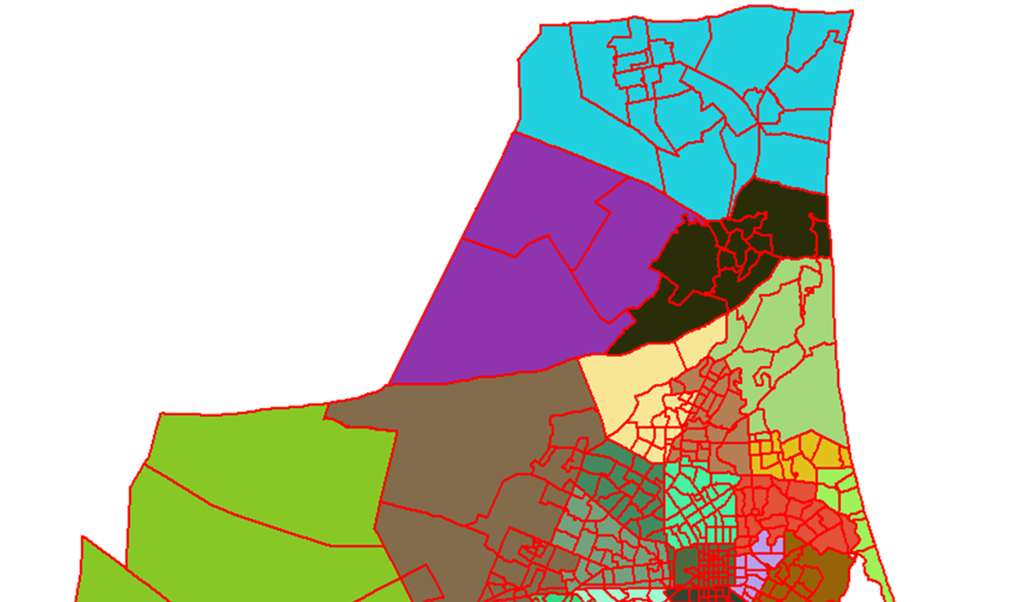
Figure 1 below shows the 25 geographic sectors with Very High traffic demands between sectors
highlighted by a large green line.
Figure 1: All Mode Person Travel between Sectors 20,000+
Review of Proposed Post-Quake Bus Network, Environment Canterbury: Report
11706 20120823-Review of Proposed Post Quake Bus Network.rep
8
5.1.1 Demand Assessment
Very high inter-sector demands in Christchurch are noted between:
Sectors 9 and 13, Bishopdale and Riccarton / Ilam
Sectors 10 and 13, St Albans / Merivale and Riccarton / Ilam
Sectors 11 and 13, Shirley / Burwood / Aranui and Riccarton / Ilam
Sectors 19 and 13, Middleton / Hoon Hay and Riccarton / Ilam
These high transport demands centred on Sector 13 are likely to be partly due to the location of
the University within this sector as well as the Westfield Mall at Riccarton.
5.1.2 Fit to Proposed Bus Network
Table 3 below identifies the proposed bus network routes that are aligned with the ‘Very High’
travel demand between CTM sectors in Christchurch.
Travel between
Descriptions
Direct Routes
Sectors 9 and 13
Bishopdale and Riccarton / Ilam
Routes E4, N5,109, 120 and the Orbiter
Sectors 10 and 13
St Albans / Merivale and Riccarton / Ilam
Route E4 and the Orbiter
Sectors 11 and 13
Shirley / Burwood / Aranui and Riccarton / Ilam
Route E4 and the Orbiter
Sectors 19 and 13
Middleton / Hoon Hay and Riccarton / Ilam
Orbiter
Table 3: Very High Demand Bus Network Fit
The highest transport demand corridors in Christchurch appear to be mostly catered for by direct
routes on the proposed network with direct travel between Sector 19 and 13 limited to the Orbiter,
thus other journeys (that do not suit use of the Orbiter between these sectors) will be more likely
to require a transfer.
Review of Proposed Post-Quake Bus Network, Environment Canterbury: Report
11706 20120823-Review of Proposed Post Quake Bus Network.rep
9
5.2
High Travel Demands
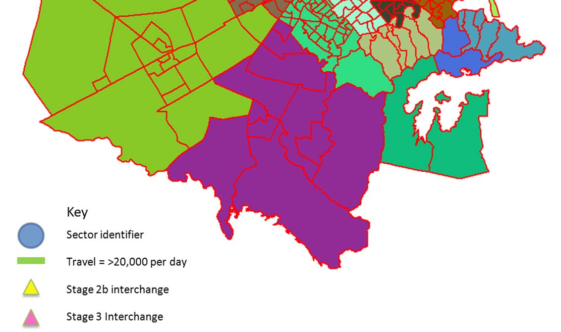
Figure 2 below shows the 25 geographic sectors with High traffic demands between sectors
highlighted by a large blue line.
Figure 2: All Mode Person Travel between sectors > 10,000 & < 20,000
Review of Proposed Post-Quake Bus Network, Environment Canterbury: Report
11706 20120823-Review of Proposed Post Quake Bus Network.rep
10
5.2.1 Demand Assessment
High inter-sector demands in Christchurch are between
Sectors 9 and 10, Bishopdale and St Albans / Merivale
Sectors 10 and 11, St Albans / Merivale and Shirley / Burwood / Aranui
Sectors 10 and 14, St Albans / Merivale and CBD
Sectors 14 and 20, CBD and Somerfield/Sydenham
Sectors 20 and 23, Somerfield/Sydenham and Cashmere Hills
Sectors 20 and 13, Somerfield/Sydenham and Riccarton / Ilam
Sectors 14 and 13, CBD and Riccarton / Ilam
Sectors 18 and 13, Halswell and Riccarton / Ilam
Sectors 21 and 13, Tai Tapu and Riccarton / Ilam
5.2.2 Fit to Proposed Bus Network
Table 4 below identifies the proposed bus network routes that are aligned with the ‘High’ travel
demand between CTM sectors in Christchurch.
Travel Between
Descriptions
Direct Routes
Sectors 9 and 10
Bishopdale and St Albans / Merivale
Orbiter
Sectors 10 and 11
St Albans / Merivale and Shirley / Burwood /
Routes 132, E4 and The Orbiter
Aranui
Sectors 10 and 14
St Albans / Merivale and CBD
Route 132, 28 & 1
Sectors 14 and 20
CBD and Somerfield / Sydenham
Route 1 and 28
Sectors 20 and 23
Somerfield / Sydenham and Cashmere Hills
Route 17 and 115
Sectors 20 and 13
Somerfield / Sydenham and Riccarton / Ilam
Indirect, requires transfer
Sectors 14 and 13
CBD and Riccarton / Ilam
Route 3
Sectors 18 and 13
Halswell and Riccarton / Ilam
Indirect, requires transfer
Sectors 21 and 13
Tai Tapu and Riccarton / Ilam
Indirect, requires transfer
Table 4: High Demand Bus Network Fit
These high transport demands associated with the University campus at Ilam and employment in
St Albans / Merivale, CBD and Somerfield / Sydenham are likely to be driving these patterns.
Whilst the majority of these high transport demand corridors in Christchurch appear to be directly
catered for by the proposed network, others will require a transfer, most often at the CBD or at
Riccarton.
Review of Proposed Post-Quake Bus Network, Environment Canterbury: Report
11706 20120823-Review of Proposed Post Quake Bus Network.rep
11
6.
Key Employment Zones
This second step of the assessment uses the updated employment allocated to model zones (a
finer definition than sectors) to consider the geographic location of key zones (employment
greater than 3,000 per zone) to the proposed bus network and its interchanges.
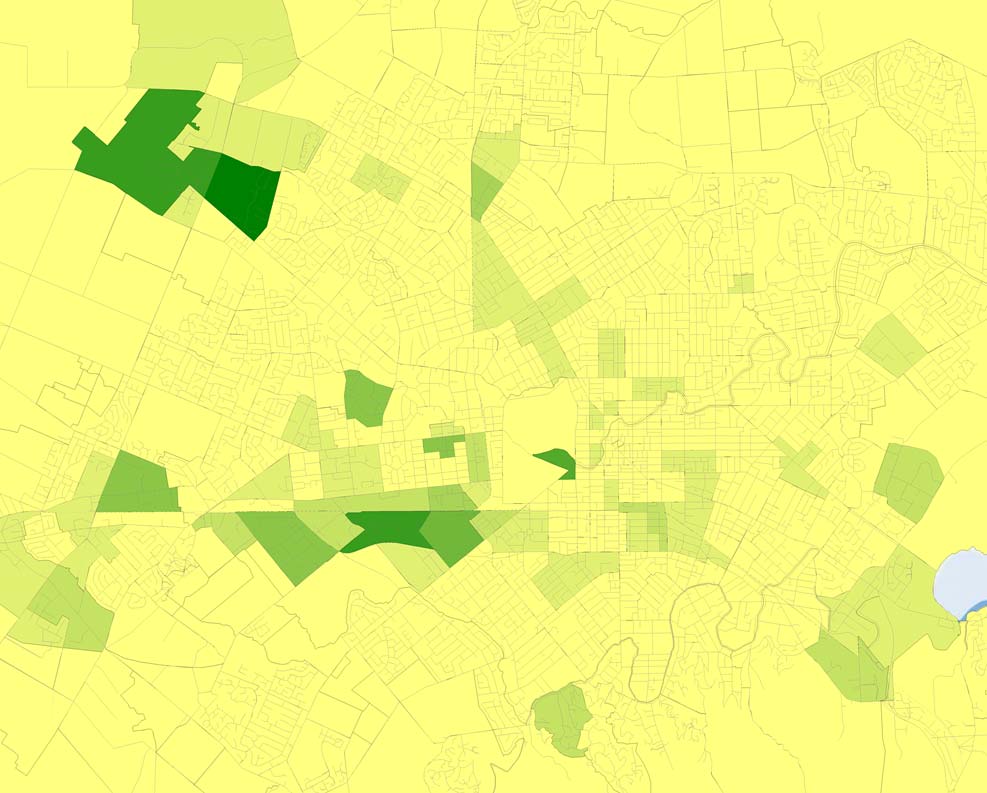
Figure 3 below shows employment by zone, with the shade of green representing the intensity,
with the darkest shading indicated the highest employment.
The Roydvale area shows the highest density of employment centred on Sir William Pickering
Drive. The other key areas of employment include the Airport, Middleton, the University, North
Hornby, Islington, Wigram, Addington, Riccarton, Papanui and Christchurch Hospital.
Figure 3: Employment Post 2011 Quake
For reference, Figure 4 overleaf shows employment by zone for Greater Christchurch. The
darker shading indicates model zones with higher employment, while the red lines show the
boundaries of the 25 model sectors. Note that the shading is the same within each model zone
and does not show individual businesses or sub-areas of high employment. As an example,
there is a large shaded zone in the south but the employment in this model zone relates primarily
to Lincoln University, located in the north east of that zone.
Review of Proposed Post-Quake Bus Network, Environment Canterbury: Report
11706 20120823-Review of Proposed Post Quake Bus Network.rep


12
Figure 4: Employment Post 2011 Quake by CTM Model Zone
Review of Proposed Post-Quake Bus Network, Environment Canterbury: Report
11706 20120823-Review of Proposed Post Quake Bus Network.rep
13
6.1
Fit to Proposed Bus Network
Looking specifically at the proposed network and its provision of services to key employment
zones (defined as greater than 3,000 employees per zone) the assessment undertaken is
reported in the following tables.
EMPLOYMENT ZONE ASSESSMENT
Zone
Access to
Proximity of
Assessment of
description
Employment of
Access to core
connector
major
access to PT
(CTM zone
zone
services
services
interchange
network
number)
Sir William
Pickering Drive /
7745 Medium
Very
good Poor Medium
Roydvale Ave
(Z288)
Airport (Z284)
5691
Good
Medium
Poor
Medium
North Hornby
3824 Medium
Medium
Medium
Medium
(Z242)
Wigram (Z222)
3592
Poor
Medium
Poor
Poor
Middleton (Z220)
5980
Poor
Good
Poor
Medium
Addington (Z183)
4152
Good
Medium
Poor
Medium
Riccarton (Z256)
3309
Very good
Very good
Very good
Very Good
University (Z272)
3125
Good
Very good
Medium
Good
Hospital (Z66)
4821
Good
Good
Medium
Good
Table 5: Employment Zone Assessment
The basis of the assessment was as follows:
Access to
Proximity of
Access to core
Rating
connector
major
services
services
interchange
No services in
No services in
No interchange in
Poor
close proximity
close proximity
proximity
1 service in close
1 service in close
Interchange
Medium
proximity
proximity
walkable
1 service within
1 service within
Interchange
Good
immediate
immediate
within close
proximity
proximity
proximity
2 or more
2 or more
Interchange
services within
services within
Very Good
within immediate
immediate
immediate
proximity
proximity
proximity
Table 6: Employment Zone Assessment Criteria
We conclude that the Wigram zone does not appear to be well served by public transport,
considering its employment density. The Middleton zone is served by one connector service and
a peak only service so given its high employment density it might not be adequately serviced. We
also observe that the Sir William Pickering Drive / Roydvale Ave employment zone is well served
by connector services but is not a location of a major interchange and could benefit from a
connection to a core service.
Review of Proposed Post-Quake Bus Network, Environment Canterbury: Report
11706 20120823-Review of Proposed Post Quake Bus Network.rep
14
7.
Recommendations for Further Investigation
Considering the outcomes of the land use change and key employment zone assessment, we
recommend the following investigation of network changes be made.
7.1
Middleton / Hoon Hay to Riccarton / Ilam
Given the observed CTM model travel demand between these two sectors and the significant
employment density in Middleton, additional direct service could be added. This could be in the
form of:
Extension of Route W6 north from its current proposed Riccarton terminus, perhaps
making it a through route with N5 and 109 (which would have the benefit of providing a
direct connection between the two most intense employment zones in Christchurch); and/or
Conversion of the peak only Middleton service to an all-day service (low frequency).
Offset departures with W6 to create a 15 minute service to/from Riccarton interchange
along Birmingham Drive.
7.2
Roydvale Ave Interchange & Route 3 Diversion
The connection of multiple services (121, N5, 109 & 120) at Roydvale Ave and the nearness of a
core route within proximity to a significant employment zone in Christchurch creates a good PT
integration opportunity through:
Creation of a purpose built interchange at this site for workers to walk to for multiple
service access; and
Diversion of Route 3 via the new interchange to allow access to a frequent service from
this zone to Riccarton / Ilam (a high travel demand zone to zone need) and to the Riccarton
Interchange and beyond.
7.3
Bishopdale to St Albans / Merivale
The Orbiter goes some way to meeting the Bishopdale to St Albans / Merivale travel demand but
it could be further catered to through the conversion of Route 132 (low frequency) to a Peak
Frequency and through routing it with 109.
7.4
Somerfield / Sydenham to Riccarton / Ilam
There is good access utilising core services, with one transfer required, to meet the high travel
demand between Somerfield/Sydenham and Riccarton / Ilam. To improve the accessibility
between these two zones would require a direct service, but maybe only in the peaks.
7.5
Halswell to Riccarton / Ilam
We have identified that there is a poor level of service supplied to the Wigram area, and a high
level of demand from Halswell to Riccarton / Ilam. A service enabling this connection would be
worth considering:
A peak only or low frequency service from Halswell to the Roydvale employment area via
the Church Corner Interchange, Ilam Road and Memorial Ave.
Review of Proposed Post-Quake Bus Network, Environment Canterbury: Report
11706 20120823-Review of Proposed Post Quake Bus Network.rep
15
An extension of Route 120 south to provide connections to Addington and Barrington.
Review of Proposed Post-Quake Bus Network, Environment Canterbury: Report
11706 20120823-Review of Proposed Post Quake Bus Network.rep
Appendix A
New Network Concept: Greater
Christchurch
Review of Proposed Post-Quake Bus Network, Environment Canterbury: Report
11706 20120823-Review of Proposed Post Quake Bus Network.rep
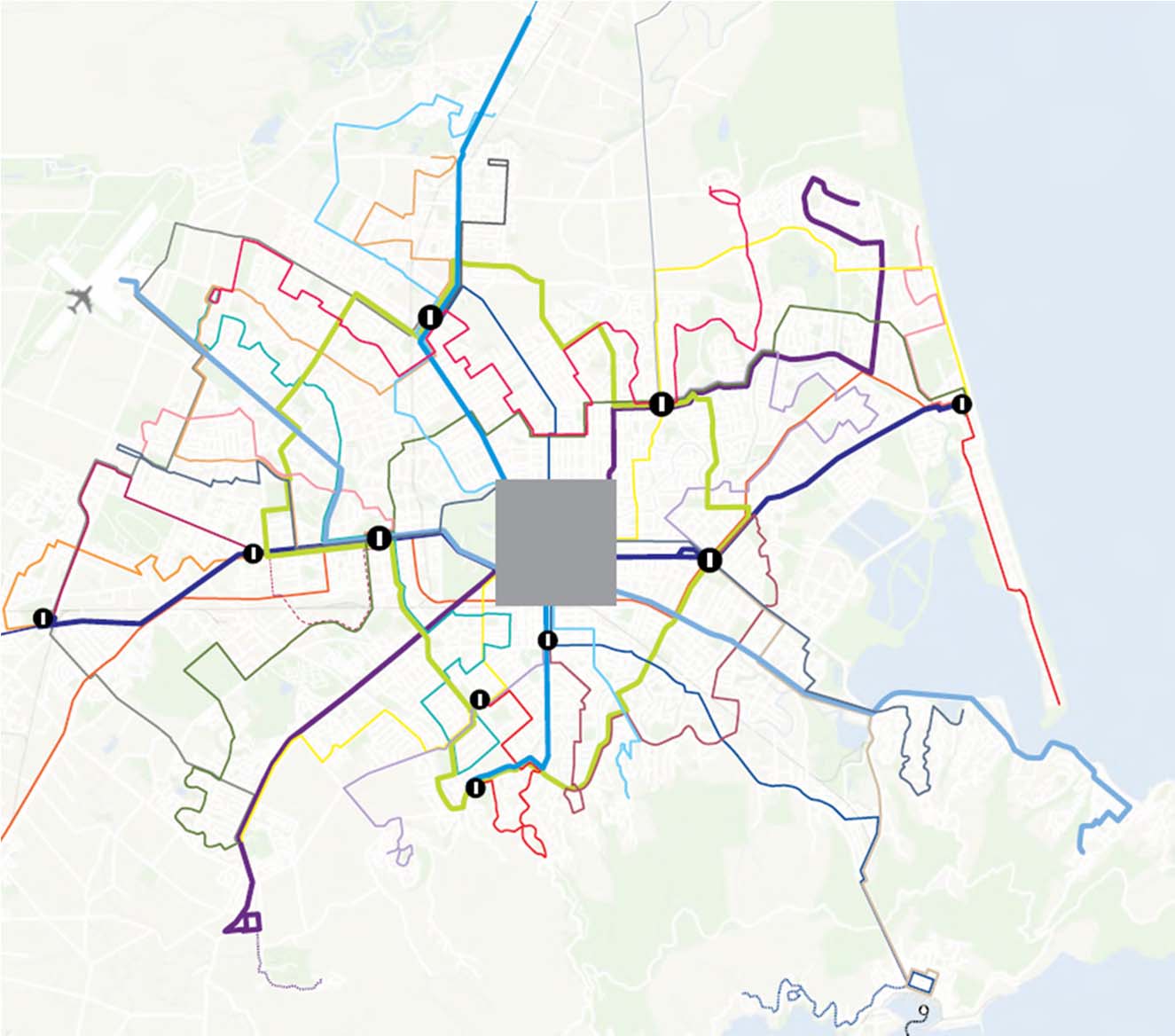
New network concept: Greater Christchurch (source: Draft Regional Public Transport Plan 2012)
Review of Proposed Post-Quake Bus Network, Environment Canterbury: Report
11706 20120823-Review of Proposed Post Quake Bus Network.rep