
 From:
From:
Strand Optimisation
To:
[email address]
Subject:
Fw: Waitemata Local Board notes - The Strand Optimisation
Date:
Wednesday, 14 February 2024 3:41:36 pm
Attachments:
image001.png
image002.png
image003.png
Outlook-zvuxmpt0.png
Ngā mihi,
The Strand Optimisation Team
Waka Kotahi NZ Transport Agency
E [email address]
/ w www.nzta.govt.nz
1982
From: Ritiksha Narayan
Sent: Friday, May 19, 2023 5:27 PM
Act
To: Angelene Burn (AT) ; Jason Heather (AT) ; Miguel Menezes (ATOC) ; Rohit Sen ; Chris Martin (ATOC)
Cc: Strand Optimisation ; s 9(2)(a) (Stantec) ; Tony Jensen (AT)
Subject: Re: Waitemata Local Board notes - The Strand Optimisation
Kia ora Angie,
Thank you, that’s very much appreciated :)
Yes, please send through to WLB, I have had this reviewed by the team already.
Have a lovely weekend!
Ngā mihi nui,
Information
Kia haumaru tō noho – Keep safe
Ritiksha Narayan (she/her)
Project Manager, He Tohu Huarahi | Bilingual Traffic Signs
Te Rōpū Waeture | Regulatory Services Group
Email: [email address]
Phone:
Official
s 9(2)(a)
Mobile: s 9(2)(a)
Waka Kotahi NZ Transport Agency
the
Auckland, Level 5, AON Centre, 29 Customs Street West
Private Bag 106602, Auckland 1143, New Zealand
Facebook | Twitter | LinkedIn
under
From: Angelene Burn (AT)
Sent: Friday, May 19, 2023 4:43:37 PM
To: Ritiksha Narayan ; Jason Heather (AT) ; Miguel Menezes (ATOC) ; Rohit Sen ; Chris Martin (ATOC)
Cc: Strand Optimisation ; s 9(2)(a) (Stantec) ; Tony Jensen (AT)
Subject: RE: Waitemata Local Board notes - The Strand Optimisation
CAUTION: The sender of this email is from outside Waka Kotahi. Do not click links, attachments, or reply unless you recognise the sender’s email
address and know the content is safe.
Good afternoon Ritiksha,
This is an amazing response, I’m really blown away. If everyone is happy with this. I will share it with the Local Board as a follow up. It’s
Released
a big read but it answers the questions really well, I’m dure thewy will be really pleased with this level of response.
………………………………
Kia ora Angie,
Please see below responses.
Outline the benefits of the proposal and how the WK (SH) functions and the AT multi modal functions come together
The proposed improvements include:
A separated shared user path - The shared user path connects to the existing Grafton Gully Shared User path just prior to Alten
Road. This will be separated from the road to improve safety.
A Special Vehicle Lane (SVL) - A special vehicle lane will be created along part of the route to improve travel efficiency for freight
and vehicles with multiple occupants (Freight, Bus and T2). The SVL is proposed to be operational between 7-10am and 4-7pm
(Monday-Friday) in both directions – depending on the outcome of additional traffic modelling and feedback. Outside of the SVL
operational time, the lane can be used by general traffic. Similar to other SVL around the city.
 Bus stop removal/relocation – Two bus stops along the strand will be relocated slightly to accommodate new pedestrian
crossings. The bus stop on The Strand near the northern end of Sudbury Terrace will be removed.
New pedestrian crossings - In total, there will be 10 new crossings in the project area. Three of these are new level signalised
pedestrian crossings along The Strand, plus one on Gladstone Road, one on Nicholls Lane and the other on the Stanley Road slip
lane to Beach Road. These crossings will all be flat to allow large vehicles, trucks and emergency vehicles to cross easily. There
will also be four raised crossings at Ronayne Street, Ngaoho Place, Cotesmore Way and Sudbury Terrace. All signalised crossings
will be activated when people press the call button only. This will help to manage the flow of traffic along the road.
Intersection improvements – Minor improvements are proposed at the SH16 / Alten Road / Nicholls Lane and Stanley Street /
Beach Road / Parnell Rise signalised intersections. The camber of the road will be adjusted along The Strand in the vicinity of the
St Georges Bay Road intersection to help reduce instances of truck roll-over events which have occurred in the past.
The benefits of making these changes would see:
·
25,000-30,000 additional freight tonnes per day moving along the road over a ten-year period
·
50% increase in cyclists with 70 - 80 new cycle trips per day
·
Reduction of serious injuries over 10 years.
The creation of a Shared User Path is separate to the road for people who walk and cycle, creates a safe environment that enables
people to feel more connected with their communities, and encourages choosing to walk, scoot and cycle as well as making walking
and cycling more attractive and people-friendly.
1982
New formalised pedestrian and shared user crossing points are all signalised and all the proposed new side street crossings are raised
tables enhancing safety at these crossings and therefore designed for human vulnerability.
Raising and shaping the road profile on the westbound traffic lane to provide a safer journey for heavy trucks around the corner (at St
Georges Bay Road). This infrastructure improvement aims to mitigate against truck-roll over crashes, by which making it safer for all
Act
users around this corner as safety is a critical priority of this project.
Outline the future for general traffic, is this reduced or in fact with improvements in place is this more reliable:
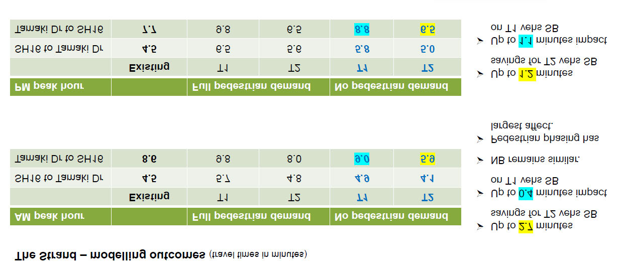
Our modelling analysis has indicated that the Special Vehicle Lane (SVL) will improve journey times and journey time reliability for
freight and high occupancy vehicles (T2) whilst limiting adverse impact to general traffic. General traffic not using the special vehicle
lane may experience an additional delay, but this is not expected to be significant. Traffic modelling analysis reporting has been
completed and can be seen below.
Please be aware that this modelling is assessed at the peak of peak hours i.e. 8-9am and 5-6pm.
The SVL has been determined to operate for Freight and T2.
Hours of operation will most likely be Monday to Friday during peak hours 7am – 10am and 4pm-7pm.
Outside of these hours, the SVL can be used by general traffic.
Information
Key:
Vehs – vehicles
SB – Southbound
NB - Northbound
Official
the
under
Additionally, if each new pedestrian crossing is called (pressed button) only 50% of the time the outcome is predicted to be similar to
Released
the situation where they are not called at all. While we have proposed the new crossings (which are part of this modelling), they are yet
to be confirmed based on the feedback received during this consultation period.
Outline the future car parking loss and opportunities, it would be good to be able to see where these locations are, I there is a
change in thinking after feedback received
We expect to retain six on-road parking spaces on the northern side of The Strand. We will be removing 18 parking spaces on the
northern side, and 21 on the southern side of The Strand. This can be seen on the attached concept design.
However, we understand the importance for parking in this area for businesses and their deliveries. As such we are proposing
formalising 35 parking spaces. This includes 12 on The Strand, 21 on Shipwright Lane and 2 loading zones on Shipwright Lane.
Parking is being considered in the SVL where this is possible i.e., where parking would not block access to property or parking. Note on
the concept plan, the blue lines are where we identify no parking based on the road changes. Yellow lines are the existing no parking
zones.
With regards to feedback, there was preference from the businesses closest to Shipwright Lane against losing any parking on the
Northern side as they do not have their own parking, however other businesses operating along The Strand who have their own parking
had no objection to parking removals as they identified the parking being used by the likes of university students for the whole day and
therefore not business customers. Parking surveys also indicated an average stay of 7 hours. Interestingly we also received feedback
from the City Centre Residents Group and public members to remove parking entirely as The Strand is part of the inner city, and they
believe there should be no parking on arterials.
We do however understand the importance for parking in this area for businesses and their deliveries and how integral these businesses
are to the Parnell community. There is an element of balance required, therefore we actively added the creation of legal parking options
where we currently are aware of illegal and dangerous parking on the footpath. The number of parking spaces provided is subject to
change based on what is finalised in the Detailed design. We are still actively working through the changes that can be applied in the
detailed design and we will update the Local Board once we have a confirmed design.
Explain the flooding mitigation workstream, how is this being managed, by who and when are we likely to have an update on this
There is a separate project working on a stormwater upgrade along a section of Stanley Street which will be included alongside this
project during construction.
ASM and Auckland Council are looking at existing and future stormwater management for the wider catchment and implications for the
transport corridor. This may include a upgrading the stormwater network in this area. Healthy Waters, a department within Auckland
Council who are responsible for stormwater management in Auckland, advised they have a current project under construction which
will connect the last section of major twin 2.5m-diameter stormwater pipes from Quay Street to the harbour outfall. Once completed,
the connection should help reduce the risk of flooding along SH16 The Strand and Beach Road areas under moderate to heavy rainfall
1982
events. The Maintenance programme for the stormwater system along the Strand is currently undergoing the review process and the
frequency to carry out routine maintenance will increase. The flood mitigation plan will include Emergency Response Plan, process,
preparedness, and key learnings from the last few flood events.
Explain the coordination with the separate safety projects at St Georges Bay Road and Gladstone Road and how these projects
Act
will be delivered? They are aware of the St Georges Bay Road crossing but not Gladstone
Signalisation of St Georges Bay Road and Gladstone Road have been identified as part of the longer-term 10-year programme.
However, this is subject to securing funding and there is no definitive timeline we can provide as it is unknown.
There are 2 pedestrian crossing projects on St Georges Bay Road led by AT. Those projects will be looking to tie in with maintenance
work in the area around March/April 2024.
Explain the mid-block crossings, has any research gone into why they are located where they are? There was discussion about a
walkable catchment and whether these were necessary or a further impediment to traffic
There is only one signalised crossing along The Strand outside Matisse Furniture Store that provides a safe crossing opportunity for
pedestrians and cyclists. Given the nearest adjacent signalised crossings are some 500m to the west at the Parnell Rise intersection and
some 450m to the east at the Tamaki Drive intersection, there is a need to provide pedestrians and cyclists with additional safe crossing
Information
opportunities at more regular intervals along the corridor. While we have new signalised crossings proposed at indicative locations,
these will be confirmed during the Detailed Design phase taking into consideration the feedback received to date as part of
consultation. The signalised crossings along The Strand will rest on green and will only activate when demanded to ensure traffic flow is
controlled through the corridor.
The current layout of the Strand has only a single pedestrian crossing along its entire length, despite its urban setting and the presence
of residential, commercial and transport connections on both sides of the road. The Strand creates significant severance to movement
Official
of vulnerable road users and the addition of the Special Vehicle Lanes (SVL) creates a four-lane carriageway which increases the
severance and risk to those wishing to cross. It also does not help with the long walking distance to cross. The project considered
signalisation of the Gladstone Road and St Georges Bay Road intersections however, due to cost implications and taking into
the
consideration the longer-term alignment for the corridor, it was decided to retain the signalised crossing components given these will
deliver important safety and amenity benefits for active mode road users. The crossing east of Ngaoho Place provides north-south
connectivity for residents and business in the area and will provide a safe crossing connection to the proposed Shared User Path on the
northern side. The crossing over the Strand at the Beach Rd intersection is existing and is proposed to change from pedestrians to
pedestrians and cyclists. Similarly, the Alten Rd crossing part of an existing intersection is proposed to change from pedestrians to
pedestrians and cyclists. Vulnerable users currently have no safe way to cross Nicholls Lane, despite there being a significant volume of
under
university students present and several large businesses in the immediate vicinity.
Additionally, crash analysis was undertaken by using Waka Kotahi’s Crash Analysis System to check the locations of previous crashes
that involved pedestrians and cyclists. The locations of the proposed crossings were then decided based on the considerations of
connectivity and demand, as well as the assessments of previous crash history.
A snapshot on who we consulted with, in particular, the businesses and the BA, noting their key feedback. We heard this was
predominately around parking and flooding?
Businesses and business associations (Parnell Business Association, Forma, Refined Living, Cuchi, Bauhaus, Home Ideas)
Residents and residents’ associations (CCRG, Gladstone Apartments, Parnell Community Committee, The Mirage Apartments,
Cotesmore Way/Sudbury Terrace BC)
Released
Local Board members
Freight associations (Ports of Auckland, National Road Carriers, Heavy Haulage)
Community groups (Heart of The City)
Cyclists and advocacy groups (Bike Auckland)
Pedestrians
Road users
University students
Property owners / tenants
Developers
Mana Whenua (Ngāti Whātua Ōrākei)
Emergency services (FENZ, NZ Police)
Transport Associations (AA, KiwiRail)
 Explain how the project is aligned to the vison of the CCMP and A4E
The City Centre Masterplan has identified the potential to transform SH16 through Grafton Gully into a multiway boulevard. A multi-
way boulevard for Grafton Gully that will continue to accommodate high freight and traffic volumes with improved traffic flow. Safer
and more civilised street edges are established to facilitate walking, cycling and local access which encouraging new mixed use
development opportunities alongside.
The Strand Improvements is a short-term project which support the longer-term City Centre Masterplan. It will contribute towards the
vision outlined in the east and west stitch in relation to an enhanced Grafton Gully and creating a multi-way boulevard.
The Strand projects objectives are also very much aligned to A4E as A4E integrates long term planning, city management and
investment and provides an opportunity to transform how people and freight move in the city centre. By enabling a decisive mode shift
away from private vehicles, it aims to make better use of finite city centre space and improve the quality of the environment.
What does the cycle network connect into? Is there a map for the links in the cycle network plan?
There is currently a missing dedicated cycle link from the Grafton Gully Shared User Path (just prior to Alten Road) and the Quay Street /
Tamaki Drive cycleway. The proposed Shared User Path is to connect this missing link.
Approval process, will there be a further opportunity to provide feedback on this project before it is approved? What is the WK
process here when moving from a concept to a detailed design.
Our timeline follows as below:
·
collate feedback
1982
·
understand how the feedback impacts detailed design
·
consider next steps to incorporate into detailed design
·
confirm detailed design
A construction start date will depend on the outcome of this engagement. Works like these are expected to take up to a year.
Act
As explained in the presentation, during detailed design we will be consulting with individual businesses who requested discussions
around the parking and delivery allocation in front of their businesses.
In terms of Waka Kotahi process, now that the consultation period has submission closed, the next step is for the Governance/Project
group to review all of feedback received and make key decisions on the improvements which are aligned with projects 3 main objectives
(this step is for Project Approval). Following from this, these decisions will be incorporated into the next stage of the project which is
Detailed Design.
Ngā mihi nui,
Kia haumaru tō noho – Keep safe
Ritiksha Narayan (she/her)
Senior Advisor | Kaitohutohu Matua
Information
Te Waka Kōtuia | Engagement and Partnerships
Email: [email address]
Phone: s 9(2)(a)
Mobile: s 9(2)(a)
Waka Kotahi NZ Transport Agency
Official
Auckland, Level 5, AON Centre, 29 Customs Street West
Private Bag 106602, Auckland 1143, New Zealand
Facebook | Twitter | LinkedIn
the
From: Angelene Burn (AT) <[email address]>
Sent: Wednesday, 10 May 2023 1:24 pm
To: Jason Heather (AT) <[email address]>; Ritiksha Narayan <[email address]>; Miguel Menezes (ATOC)
<[email address]>; Rohit Sen <[email address]>; Chris Martin (ATOC) <[email address]>
under
Cc: Angelene Burn (AT) <[email address]>
Subject: Waitemata Local Board notes - The Strand Optimisation
CAUTION: The sender of this email is from outside Waka Kotahi. Do not click links, attachments, or reply unless you recognise the sender’s email address and know
the content is safe.
Good afternoon Strand Optimisation Team,
Thanks for everyone who participated in the project update to the Waitemata Local Board yesterday. There was quite a bit of
discussion and unfortunately we did run out of time, but they appreciated the update on the consultation feedback, and they certainly
liked the way that the project seeks to address water and flooding along the Strand and will cater for better safer, more inclusive
urban outcomes on a main road currently dominated by trucks.
Released
For their improved understanding, it would be great to be able to collate the information I have set out below:
Outline the benefits of the proposal and how the WK (SH) functions and the AT multi modal functions come together
Outline the future for general traffic, is this reduced or in fact with improvements in place is this more reliable
Outline the future car parking loss and opportunities, it would be good to be able to see where these locations are, I there is a
change in thinking after feedback received
Explain the flooding mitigation workstream, how is this being managed, by who and when are we likely to have an update on
this
Explain the coordination with the separate safety projects at St Georges Bay Road and Gladstone Road and how these projects
will be delivered? They are aware of the St Georges Bay Road crossing but not Gladstone
Explain the mid-block crossings, has any research gone into why they are located where they are? He talked about a walkable
catchment and whether these were necessary or a further impediment to traffic
A snapshot on who we consulted with, in particular, the businesses and the BA, noting their key feedback. We heard this was

predominately around parking and flooding?
Explain how the project is aligned to the vison of the CCMP and A4E
What does the cycle network connect into? Is there a map for the links in the cycle network plan?
Approval process, will there be a further opportunity to provide feedback on this project before it is approved? What is the WK
process here when moving from a concept to a detailed design.
I received this email from a LB member when she had been to one of the drop in sessions, I think some of the above questions will
help us cover this off well.
I know there has been feedback from some asking for more bike safety, and others asking for only one pedestrian crossing while the
Parnell Business Association wants a crossing at St George’s Bay Road. For me I think the intentions of the project do generally meet the
brief, to improve freight movements and improve safety and enable multiple modes but also support a detailed design being responsive
to feedback and further thought. It would be good if there are changes (or not) to get an AT response as to why they have moved
forward the way they have.
Thank you all its great to work with you all,
Angie
Ngā mihi | Kind regards
Angelene Burn | Elected Member Relationship Partner |
Senior Engagement Partner
1982
Central Hub | Stakeholders, Communities & Communication
Level 2, 20 Viaduct Harbour, Auckland 1010
Private Bag 92250, Auckland 1142
s 9(2)(a)
[email address]
Act
We all have an important part to play in helping to reduce the spread of COVID-19 in our communities. Find the latest information and advice from
Auckland Transport. For the latest news from the Ministry of Health go to the Unite Against Covid-19 website.
Important notice: The contents of this email and any attachments may be confidential and subject to legal privilege. If you have received this email message in error please notify us
immediately and erase all copies of the message and attachments; any use, disclosure or copying of this message or attachments is prohibited. Any views expressed in this email may be
those of the individual sender and may not necessarily reflect the views of Auckland Transport.
This message, together with any attachments, may contain information that is classified and/or subject to legal privilege. Any
Information
classification markings must be adhered to. If you are not the intended recipient, you must not peruse, disclose, disseminate, copy or
use the message in any way. If you have received this message in error, please notify us immediately by return email and then destroy
the original message. This communication may be accessed or retained by Waka Kotahi NZ Transport Agency for information
assurance purposes.
Important notice: The contents of this email and any attachments may be confidential and subject to legal privilege. If you have received this email message in error
please notify us immediately and erase all copies of the message and attachments; any use, disclosure or copying of this message or attachments is prohibited. Any
views expressed in this email may be those of the individual sender and may not necessarily reflect the views of Auckland Transport.
Official
the
under
Released