
Palmerston North City Council
TE MOTU O POUTOA - ECOLOGY
SCHEDULE 6 ASSESSMENT
21 OCTOBER 2024
CONFIDENTIAL
Dixon 23/05/2025
M S
to
- released
SRC0280925
LGOIMA
TE MOTU O POUTOA - ECOLOGY
SCHEDULE 6 ASSESSMENT
Palmerston North City Council
WSP
Whanganui
74 Ingestre Street
PO Box 654
Whanganui 4541, New Zealand
+64 6 349 6600
23/05/2025
wsp.com/nz
NAME
ROLE
DATE
S Dixon
Prepared by:
s7(2)(a) Privacy Senior Ecologist
10 October 2024
M
Reviewed by:
Technical Principal - Ecology
10 October 2024
to
Approved by:
Technical Principal - Planning
- released
SRC0280925
This report (‘Report’) has been prepared by WSP exclusively for Palmerston North City Council (‘Client’)
LGOIMA
in relation to this high-level ecological assessment (‘Purpose’) and in accordance with the contract no.
04138 Transport and 3 Waters Design Panel - WSP. The findings in this Report are based on and are
subject to the assumptions specified in the Report and the Offer of Services dated 19 August 2024].
WSP accepts no liability whatsoever for any reliance on or use of this Report, in whole or in part, for any
use or purpose other than the Purpose or any use or reliance on the Report by any third party.
5-P1569.FB
Confidential
21 October
2024

23/05/2025
S Dixon
M
to
- released
SRC0280925
LGOIMA
WSP
Whanganui
74 Ingestre Street
PO Box 654
Whanganui 4541, New Zealand
+64 6 349 6600
wsp.com/nz

1
INTRODUCTION .....................................................................................................1
TABLE OF
1.1
BACKGROUND & PURPOSE ........................................................................ 1
CONTENTS
1.2
SITE LOCATION & ECOLOGICAL DISTRICT ........................................ 1
1.3
PROPOSED WORKS ......................................................................................... 2
2
SURVEY METHODOLOGY ........................................................................ 4
23/05/2025
3
VEGETATION DESCRIPTION .................................................................. 5
3.1
VB1 ................................................................................................................................ 5
3.2
VB2 ................................................................................................................................ 7
S Dixon
3.3
VB3 ............................................................................................................................... 9
M
3.4
VB4 ............................................................................................................................. 10
to
4
POTENTIAL WETLAND AREAS .......................................................... 12
5
CONCLUSION ....................................................................................................... 13
6
REFERENCES ........................................................................................................ 14
- released
SRC0280925
LGOIMA
1
INTRODUCTION
1.1
BACKGROUND & PURPOSE
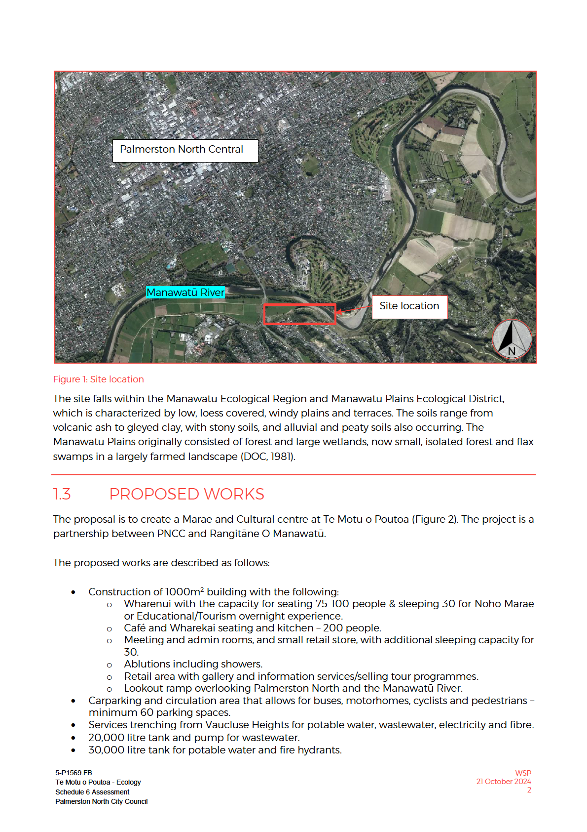
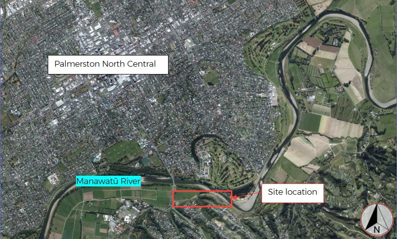
Palmerston North City Council (PNCC) are proposing a development of an area of land located at Te
Motu o Pouta. This development includes a new urban marae, adjoining ablution block,
commercial grade kitchen and dining area, café and future retail space. The development also
includes new landscaping, parking areas, and passing bays to enable safe traffic movements up Cliff
Road, which is a relatively narrow local road.
The current design proposes to clear a significant amount of existing vegetation to facilitate the
23/05/2025
proposal. The purpose of this report is to determine whether the vegetation to be cleared for the
proposed activity meets the criteria set out in Schedule 6 of the Horizons Regional Council (HRC)
One Plan being a rare, threatened or at-risk habitat.
During this assessment the site was also briefly assessed for the presence of any natural inland
wetlands. The purpose of this assessment as to determine any potential vegetation based
S Dixon
consenting triggers.
M
1.2
SITE LOCATION & ECOLOGICAL DISTRICT
to
The Project sits within the Manawatū-Whanganui Region under the jurisdiction of PNCC and the
Horizons Regional Council (HRC). The general location of the Project is shown in Figure 1 below. The
Project sits on the south-eastern urban boundary of Palmerston North in the suburb of Fitzherbert,
separated from Palmerston North City by the Manawatū River.
The surrounding land is predominantly a mix of residential and recreation areas. There is an existing
walking path that can be accessed from Cliff Road and loops around Te Motu o Poutoa. The Te Arapiki
- released
a Tane walking track can be accessed from the existing Te Motu o Poutoa carpark. Te Motu-o-Poutoa
also connects several green corridors: Tararua-Gorge Corridor, North Manawatu-Gorge Corridor and
Turitea Stream Corridor.
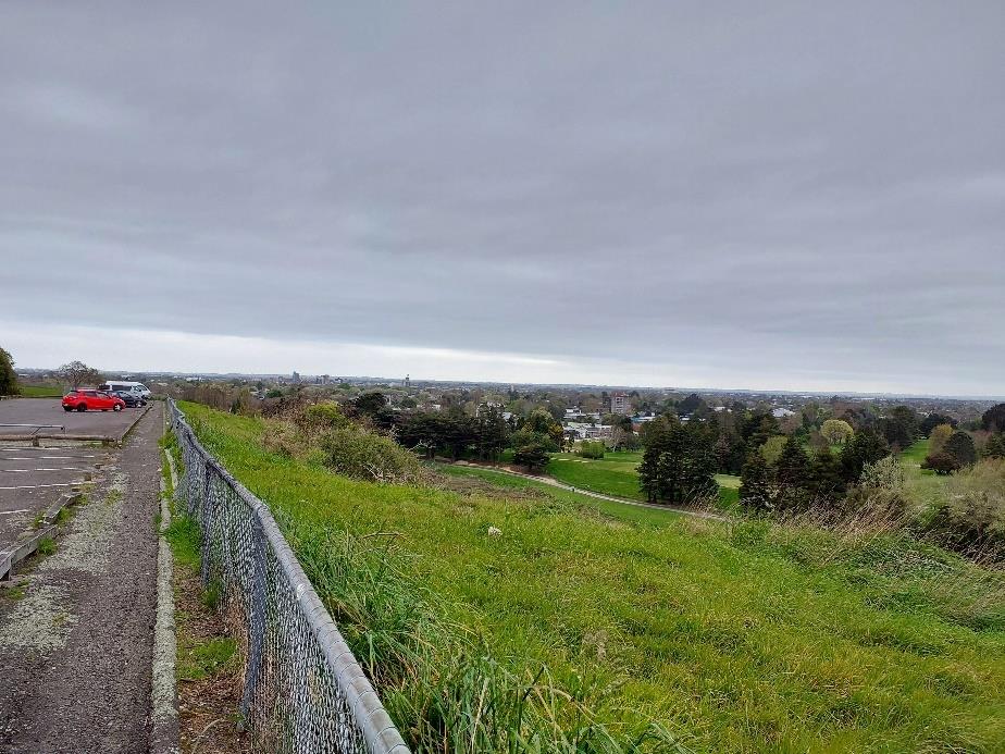
The majority of the site at the top of the hill is currently unvegetated with a large asphalt carpark and
managed lawns. To the southeast of the site is the Palmerston North Astronomical Society
observatory that was built in 1971.
SRC0280925
LGOIMA
5-P1569.FB
WSP
Te Motu o Poutoa - Ecology
21 October 2024
Schedule 6 Assessment
1
Palmerston North City Council
23/05/2025
S Dixon
M
to
- released
SRC0280925
LGOIMA
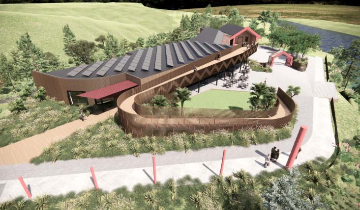
• Three 30,000 litre tanks for stormwater. The stormwater is to be released into the existing
natural water course south of the site.
• Installation of fire hydrants.
• Installation of transformer.
• Clearance of existing vegetation at the site for the works to take place.
• Landscaping at the site – including lawn areas, reinforced grass, garden beds, plantings and
hangi pits.
23/05/2025
S Dixon
M
to
- released
Figure 2: Design of the proposal (Concept Design Report).
SRC0280925
LGOIMA
5-P1569.FB
WSP
Te Motu o Poutoa - Ecology
21 October 2024
Schedule 6 Assessment
3
Palmerston North City Council
2
SURVEY METHODOLOGY
The potential impact area was assessed during a site visit on the 26th of September 2024. This site
visit was undertaken by a WSP Senior Ecologist.
The site visit included identifying dominant vegetation types present within the area and
determining whether they met the criteria set out in Schedule 6 of the Horizons Regional Council
One Plan. Rapid wetland delineations were also undertaken in areas where wetland vegetation was
noted (Mfe, 2020), the purpose of this was to determine whether they meet the criteria of being
natural inland wetlands as defined in the NPS-F (2020).
23/05/2025
S Dixon
M
to
- released
SRC0280925
LGOIMA
5-P1569.FB
WSP
Te Motu o Poutoa - Ecology
21 October 2024
Schedule 6 Assessment
4
Palmerston North City Council
3
VEGETATION DESCRIPTION
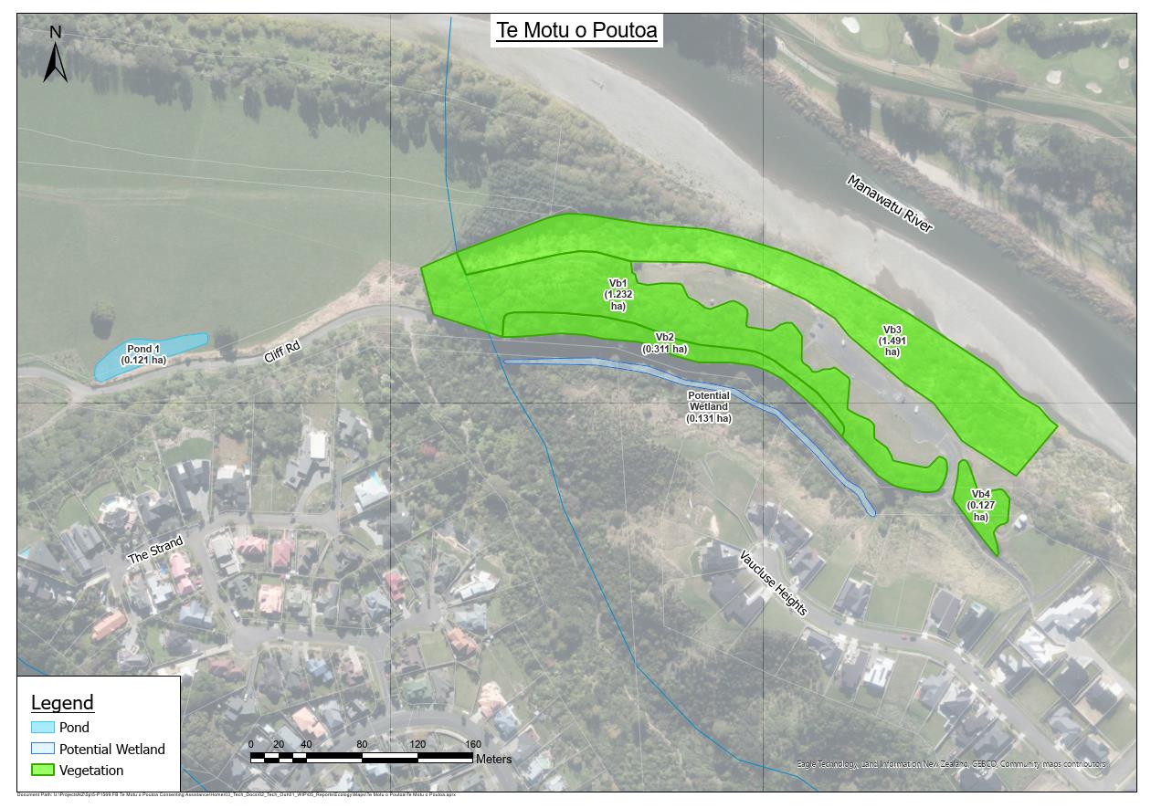
The vegetation surrounding the proposed development area was split into four separate vegetated
blocks ( Figure 3). Each of these vegetated blocks is described in detail below.
23/05/2025
S Dixon
M
to
- released
Figure 3: Map of ecological features onsite.
3.1
VB1
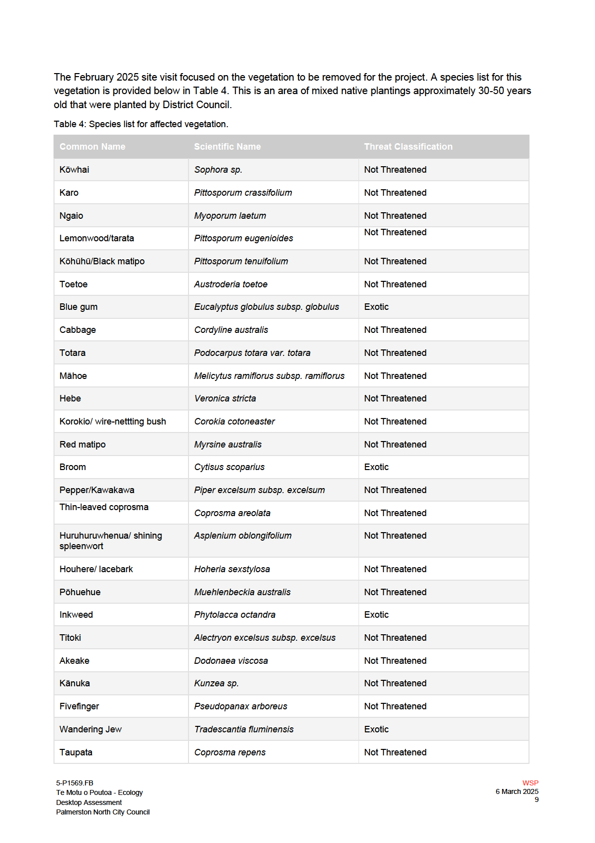
VB1 is an area of mixed native plantings approximately 30-50yrs old, planted by the district council.
This area is approximately 1.23ha. Dominated in a mix of common native and exotic species (Table 1,
Figure 4). SRC0280925
This vegetation block does not meet the criteria of being an At Risk or Threatened habitat under
the Horizons Regional Council One Plan Schedule 6, based on its species composition and planted
nature. This vegetated block likely provides suitable habitat for native fauna.
Table 1: Species found in VB1.
Common Name
Scientific Name
Threat Classification
LGOIMA
Kōwhai
Sophora sp.
Not Threatened
Karo
Pittosporum crassifolium
Not Threatened
5-P1569.FB
WSP
Te Motu o Poutoa - Ecology
21 October 2024
Schedule 6 Assessment
5
Palmerston North City Council
Ngaio
Myoporum laetum
Not Threatened
Not Threatened
Lemonwood/tarata
Pittosporum eugenioides
Kōhūhū/Black matipo
Pittosporum tenuifolium
Not Threatened
Broadleaf/ kāpuka
Griselinia littoralis
Not Threatened
Hen and chicken fern/
Asplenium bulbiferum
Not Threatened
pikopiko
Swamp kiokio
Parablechnum minus
Not Threatened
Banksia
Banksia sp.
Exotic
23/05/2025
Toetoe
Austroderia toetoe
Not Threatened
Blue gum
Eucalyptus globulus subsp.
Exotic
globulus
Cabbage
Cordyline australis
Not Threatened
S Dixon
Totara
Podocarpus totara var. totara
Not Threatened
M
Māhoe
Melicytus ramiflorus subsp.
Not Threatened
ramiflorus
to
Hebe
Veronica stricta
Not Threatened
Korokio/ wire-nettting bush
Corokia cotoneaster
Not Threatened
Red matipo
Myrsine australis
Not Threatened
Broom
Cytisus scoparius
Exotic
- released
Pepper/Kawakawa
Piper excelsum subsp. excelsum
Not Threatened
Thin-leaved coprosma
Coprosma areolata
Not Threatened
Huruhuruwhenua/ shining
Asplenium oblongifolium
Not Threatened
spleenwort
Houhere/ lacebark
Hoheria sexstylosa
Not Threatened
Pōhuehue
Muehlenbeckia australis
Not Threatened
SRC0280925
Inkweed
Phytolacca octandra
Exotic
Titoki
Alectryon excelsus subsp. excelsus
Not Threatened
Akeake
Dodonaea viscosa
Not Threatened
Silk tree
Albizia julibrissin
Exotic
LGOIMA
Manuka
Leptospermum sp.
Not Threatened
Kānuka
Kunzea sp.
Not Threatened
Flax
Phormium tenax
Not Threatened
5-P1569.FB
WSP
Te Motu o Poutoa - Ecology
21 October 2024
Schedule 6 Assessment
6
Palmerston North City Council
Fivefinger
Pseudopanax arboreus
Not Threatened
Wandering Jew
Tradescantia fluminensis
Exotic
23/05/2025
S Dixon
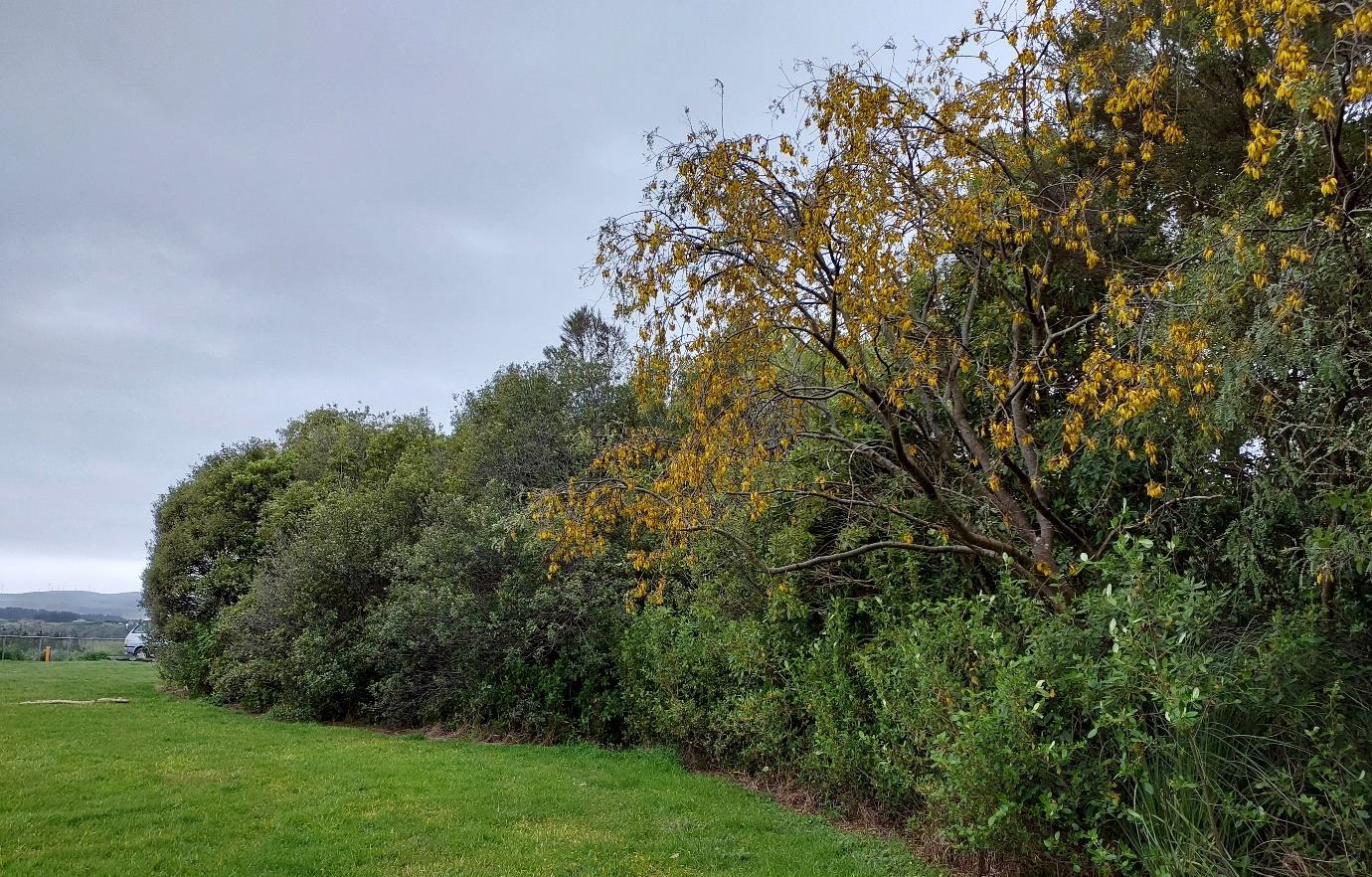
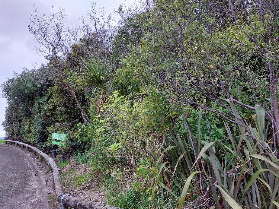
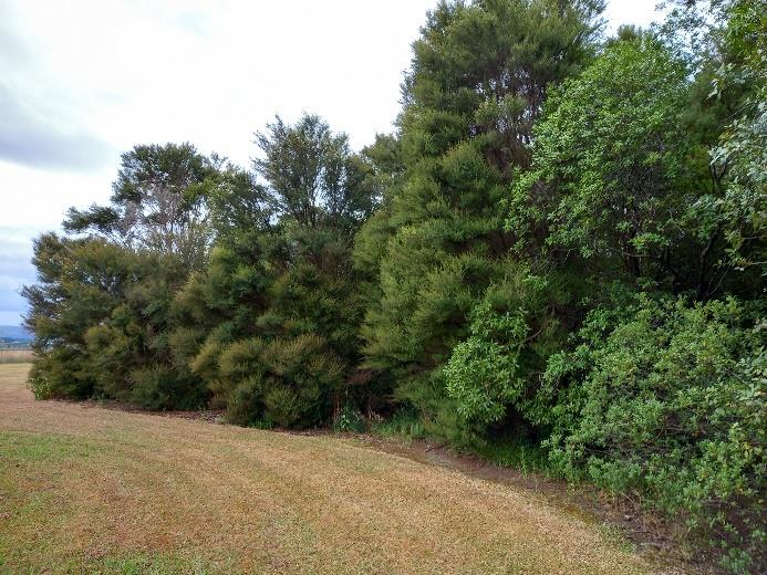
Figure 4: Photos of VB1.
M
3.2
VB2
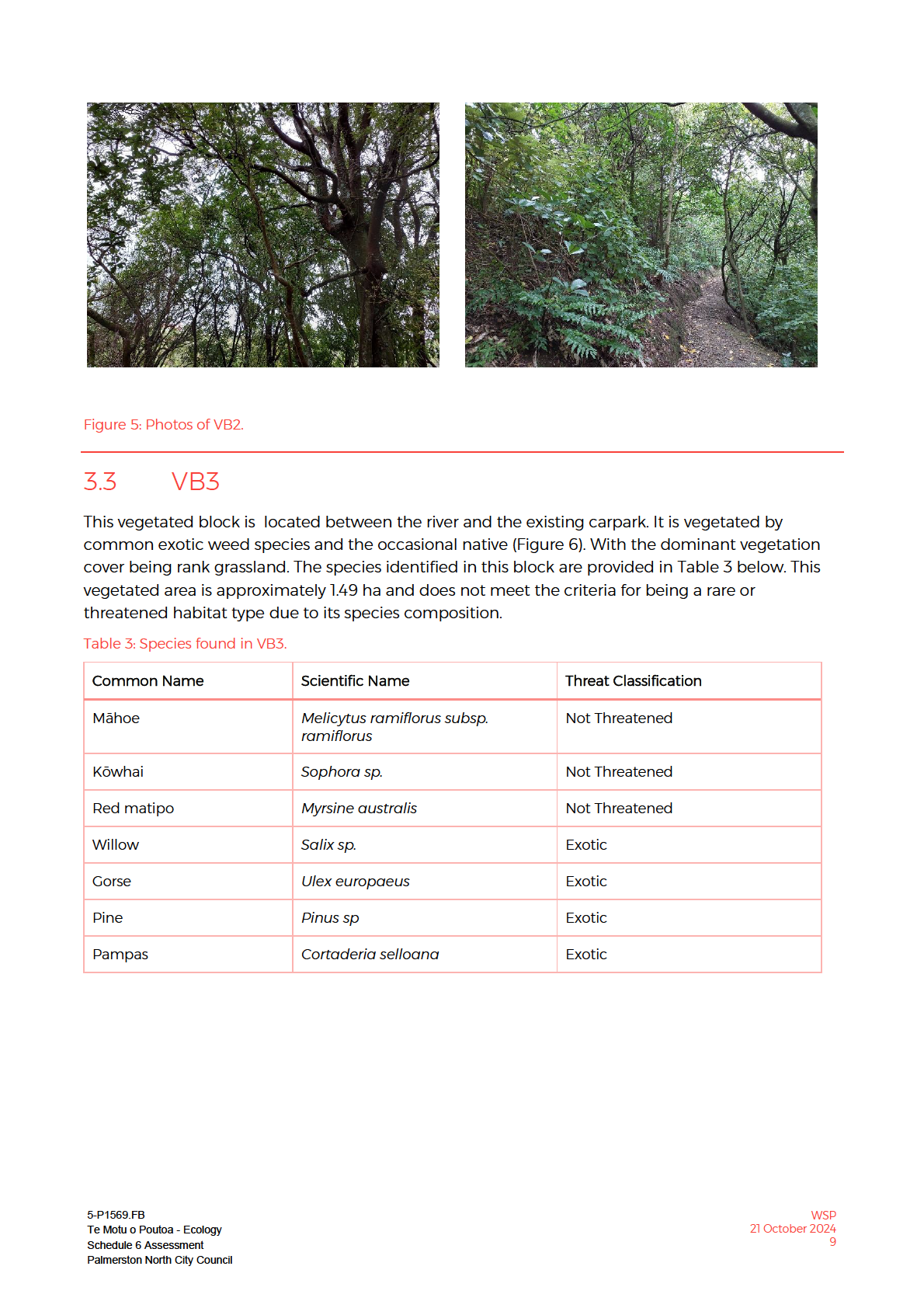
to
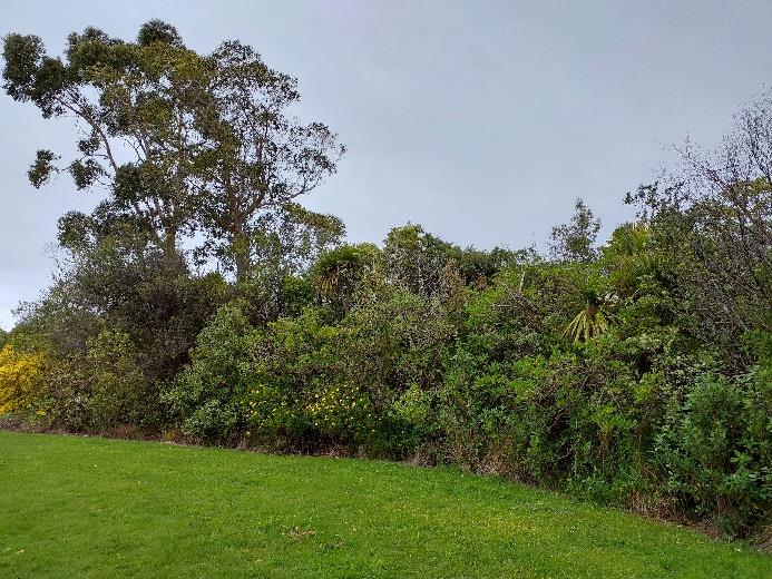
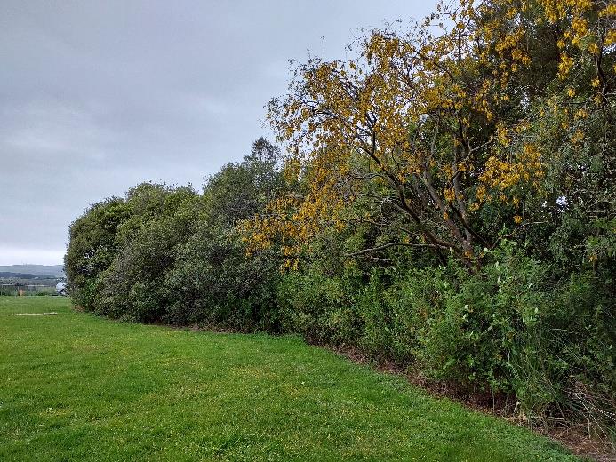
Is an area of podocarp forest, dominated by mahoe with emergent tawa trees, this area was noted
to have minimal understorey vegetation (Figure 5). This area is approximately 0.31 ha and meets the
criteria of being a podocarp/tawa-mahoe forest or treeland which is a threatened environment type
under Schedule 6 of the HRC One Plan and meets the required size criteria (Table 46 – Schedule 6)
of being an area greater than 0.25ha. The species identified in this vegetation block are provided in
Table 2 below.
- released
While VB2 meets the Schedule 6 criteria discussed above, it is important to note that Table 47 of
Schedule 6 states that an area of indigenous vegetation classified as Threatened or At Risk must
NOT be classified as a Schedule 6 habitat if it is an area of vegetation that was “
…planted for
landscaping, horticultural, shelter belts, gardening or amenity purposes”. As the vegetation in area
VB1 to VB3 was originally planted by PNCC, confirmation is required as to the reason for these
plantings and as such this could change the status of this vegetation. However, it is important to
note that VB2 contains emergent tawa which are likely to pre-date these plantings.
Table 2: Species present in VB2.
SRC0280925
Common Name
Scientific Name
Threat Classification
Kōwhai
Sophora sp.
Not Threatened
Not Threatened
Lemonwood/tarata
Pittosporum eugenioides
Kōhūhū/Black matipo
Pittosporum tenuifolium
Not Threatened
LGOIMA
Broadleaf/ kāpuka
Griselinia littoralis
Not Threatened
Totara
Podocarpus totara var. totara
Not Threatened
5-P1569.FB
WSP
Te Motu o Poutoa - Ecology
21 October 2024
Schedule 6 Assessment
7
Palmerston North City Council
Māhoe
Melicytus ramiflorus subsp.
Not Threatened
ramiflorus
Red matipo
Myrsine australis
Not Threatened
Pepper/Kawakawa
Piper excelsum subsp. excelsum
Not Threatened
Thin-leaved coprosma
Coprosma areolata
Not Threatened
Huruhuruwhenua/ shining
Asplenium oblongifolium
Not Threatened
spleenwort
Houhere/ lacebark
Hoheria sexstylosa
Not Threatened
Manuka
Leptospermum sp.
Not Threatened
23/05/2025
Kānuka
Kunzea sp.
Not Threatened
Flax
Phormium tenax
Not Threatened
Rangiora/ bushman’s toilet
Brachyglottis repanda
Not Threatened
paper
S Dixon
Leatherleaf fern
Pyrrosia elaeagnifolia
Not Threatened
M
Fivefinger
Pseudopanax arboreus
Not Threatened
to
Wandering Jew
Tradescantia fluminensis
Exotic
Supplejack
Ripogonum scandens
Not Threatened
Asparagus fern
Asparagus plumosus
Exotic
Rata
Metrosideros colensoi
Not Threatened
- released
Tawa
Beilschmiedia tawa
Not Threatened
SRC0280925
LGOIMA
5-P1569.FB
WSP
Te Motu o Poutoa - Ecology
21 October 2024
Schedule 6 Assessment
8
Palmerston North City Council
23/05/2025
S Dixon
M
to
- released
SRC0280925
LGOIMA
23/05/2025
Figure 6: Photo of VB3.
S Dixon
3.4
VB4
M
VB4 is an area of common native species with the occasional exotic (it is 0.127ha). Located adjacent
to
to the existing carpark and to the west of the observatory building (Figure 7). It is an area of relatively
undisturbed vegetation. It does not meet the criteria of being a rare or threatened habitat under
Schedule 6 of the HRC One Plan, due to its species composition. The species found in this
vegetation block are listed in Table 4 below. It is likely that this block provides suitable habitat for
native fauna.
Table 4: Species identified as present in VB4. - released
Common Name
Scientific Name
Threat Classification
Karo
Pittosporum crassifolium
Not Threatened
Cabbage
Cordyline australis
Not Threatened
Blackwood
Acacia melanoxylon
Exotic
Pepper/Kawakawa
Piper excelsum subsp. excelsum
Not Threatened
Not Threatened
Korokio/ wire-nettting bush
Corokia cotoneaster
SRC0280925
Karamū
Coprosma robusta
Not Threatened
Totara
Podocarpus totara var. totara
Not Threatened
Fivefinger
Pseudopanax arboreus
Not Threatened
Swamp kiokio
Parablechnum minus
Not Threatened
LGOIMA
Pine
Pinus sp
Exotic
Ngaio
Myoporum laetum
Not Threatened
5-P1569.FB
WSP
Te Motu o Poutoa - Ecology
21 October 2024
Schedule 6 Assessment
10
Palmerston North City Council
Red matipo
Myrsine australis
Not Threatened
Lemonwood/tarata
Pittosporum eugenioides
Not Threatened
Kōwhai
Sophora sp.
Not Threatened
Māhoe
Melicytus ramiflorus subsp.
Not Threatened
ramiflorus
Kōhūhū/Black matipo
Pittosporum tenuifolium
Not Threatened
Flax
Phormium tenax
Not Threatened
Gorse
Ulex europaeus
Exotic
23/05/2025
Inkweed
Phytolacca octandra
Exotic
S Dixon
M
to
- released
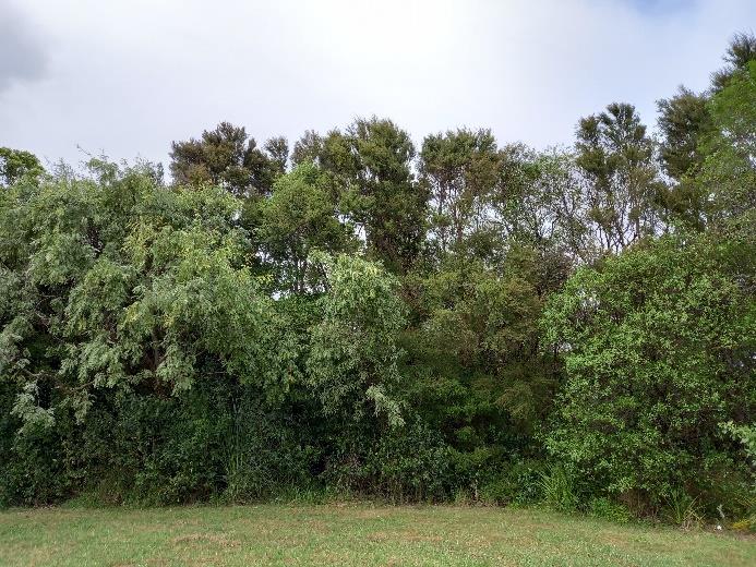
Figure 7: Photo of VB4.
SRC0280925
LGOIMA
5-P1569.FB
WSP
Te Motu o Poutoa - Ecology
21 October 2024
Schedule 6 Assessment
11
Palmerston North City Council
4
POTENTIAL WETLAND AREAS
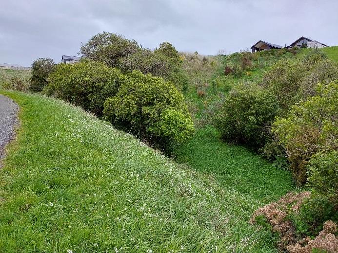
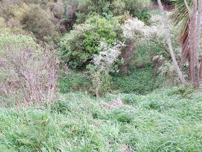
A potential wetland area was noted in the vicinity of the project area, this wetland area was located
running along the bottom of a gully adjacent to Cliff Road ( Figure 3). This wetland area was not
formally delineated. Further assessment of this area is required should the potential works impact
this site.
23/05/2025
S Dixon
M
to
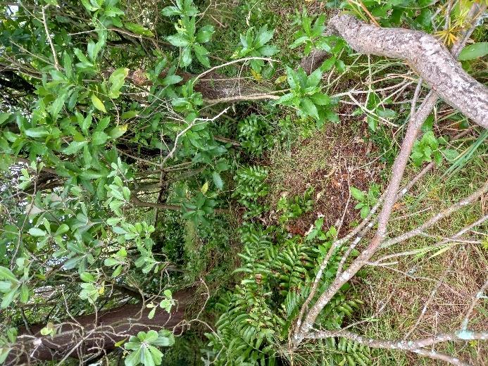
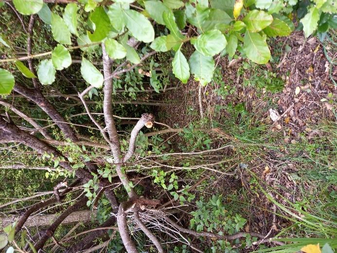
Figure 8: Photos showing potential wetland area.
- released
SRC0280925
LGOIMA
5-P1569.FB
WSP
Te Motu o Poutoa - Ecology
21 October 2024
Schedule 6 Assessment
12
Palmerston North City Council
5
CONCLUSION
The vegetation likely to be impacted by the proposal comprises common native and exotic species.
No threatened species were noted during the site visit. The majority of the vegetation does not
meet the criteria for being a rare or threatened species under Schedule 6 of the HRC One Plan,
other than potentially VB2.
Further information is required from Palmerston North City Council as to the purpose of the
plantings that were undertaken onsite. If they were undertaken for amenity or landscape purposes
then VB2 cannot be classed as a threatened environment type under Schedule 6, however it is
important to note that areas of VB2 are likely natural forest due to the presence of emergent tawa.
It is important to note the potential wetland area within 100m of the proposed works site. This will
23/05/2025
require further assessment once final design is complete to ensure that the proposed works do not
result in partial drainage of this wetland area and or adverse effects of this wetland area.
It is recommended that a full ecological impact assessment is undertaken to ensure that the full
suite of ecological effects are considered, particularly the effects of significant vegetation clearance
on native fauna (birds, bats and lizards) and consideration of the wider areas ecological values
S Dixon
including ecological context, local diversity and ecosystem values. M
to
- released
SRC0280925
LGOIMA
5-P1569.FB
WSP
Te Motu o Poutoa - Ecology
21 October 2024
Schedule 6 Assessment
13
Palmerston North City Council
6
REFERENCES
Clarkson B, R. (2013): A Vegetation Tool for Wetland Delineation in New Zealand. Prepared for
Meridian Energy Limited, December 2013. Maanaki Whenua Landcare Research,
10.7931/J2TD9V77.
Clarkson BR, Fitzgerald NB, Champion PD, Forester L, Rance BD. (2021): New Zealand wetland plant
list 2021. Manaaki Whenua - Landcare Research contract report LC3975 for Hawke's Bay
Regional Council.
Department of Conservation (DOC). Retrieved 2023. Ecological regions and districts of New Zealand.
New Zealand Topographical Map. NZMS 242 - sheet 2.
Found online at: ecological_regions_maps.pdf (doc.govt.nz)
23/05/2025
Department of Conservation (DOC). 1987. Ecological regions and districts of New Zealand.
New
Zealand Biological Resource Centre – third revised edition: sheet 3.
Horizons Regional Council (2024). One Plan as amended by Plan Amendment 4.
Ministry for the Environment (MfE). (2020): Wetland Delineation Protocols. Wellington: Ministry for
S Dixon
the Environment.
M
NES-F (2020): Resource Management (National Environmental Standards for Freshwater)
Regulations 2020.
New Zealand Government. to
NPS-FM (2020), National Policy Statement for Freshwater Management.
New Zealand Government.
- released
SRC0280925
LGOIMA
5-P1569.FB
WSP
Te Motu o Poutoa - Ecology
21 October 2024
Schedule 6 Assessment
14
Palmerston North City Council
23/05/2025
S Dixon
M
to
- released
SRC0280925
LGOIMA
23/05/2025
Te Motu o Poutoa - Ecology
S Dixon
Ecological Impact Assessment
M
Palmerston North City Council
to
WSP
Whangarei
Mansfield Terrace Service Lane
125A Bank Street
PO Box 553
Whangarei 0140, New Zealand
+64 9 430 1700
wsp.com/nz
- released
REV
DATE
DETAILS
A
27/02/2025
Ecological Impact Assessment Draft
NAME
ROLE
DATE
s7(2)(a) Privacy Senior Ecologist
Prepared by:
24-02-2025
Graduate Ecologist
SRC0280925
Reviewed by:
Technical Principal Ecology
28-02-2025
Approved by:
Principal Planner
LGOIMA
This report (‘Report’) has been prepared by WSP exclusively for Palmerston North City Council (‘Client’) in relation to this
ecological desktop assessment (‘Purpose’) and in accordance with the contract no. 04138 Transport and 3 Waters
Design Panel – WSP. The findings in this Report are based on and are subject to the assumptions specified in the
Report and the Offer of Services dated 19 August 2024. WSP accepts no liability whatsoever for any reliance on or use
of this Report, in whole or in part, for any use or purpose other than the Purpose or any use or reliance on the Report by
any third party.
5-P1569.FB
28 February
2025
 1
INTRODUCTION.................................................................................. 1
1
INTRODUCTION.................................................................................. 1
TABLE OF
1.1
BACKGROUND .................................................................................... 1
CONTENTS
1.2
SCOPE .................................................................................................. 1
1.3
SITE LOCATION & ECOLOGICAL DISTRICT ..................................... 1
1.4
PROPOSED WORKS ............................................................................ 2
23/05/2025
2
ECOLOGICAL ASSESSMENT METHODOLOGY .................................... 4
2.1
DESKTOP ASSESSMENT .................................................................... 4
2.2
FIELD SURVEY..................................................................................... 4
2.3
EIANZ GUIDELINES ............................................................................. 5
2.3.1
EIANZ GUIDELINES ....................................................................................... 5
S Dixon
2.3.2
ECOLOGICAL VALUES ASSESSMENT ..................................................... 5
2.3.3
MAGNITUDE OF EFFECTS ASSESSMENT .............................................. 6
M
2.3.4
LEVEL OF EFFECTS ASSESSMENT ......................................................... 7
to
3
ASSESSMENT OF ECOLOGICAL VALUE .............................................. 8
3.1
SITE OVERVIEW .................................................................................. 8
3.2
VEGETATION ....................................................................................... 8
3.3
BIRDS ..................................................................................................10
3.4
BATS ....................................................................................................12
- released
3.5
LIZARDS ..............................................................................................12
4
ASSESSMENT OF ECOLOGICAL EFFECT .......................................... 14
4.1
VEGETATION ......................................................................................14
4.2
BIRDS ..................................................................................................14
4.3
LIZARDS ..............................................................................................14
4.4
BATS ....................................................................................................15
5
RECOMMENDATIONS ....................................................................... 16
SRC0280925
5.1 BIRD MANAGEMENT ..........................................................................16
5.2
BAT MANAGEMENT ...........................................................................16
5.3
LIZARD MANAGEMENT .....................................................................16
6
CONCLUSIONS ................................................................................ 17
LGOIMA
REFERENCES ................................................................................................ 18
1
INTRODUCTION
1.1
BACKGROUND
Palmerston North City Council (PNCC) are proposing to develop an area of land located at Te Motu o Pouta.
This development includes a new urban marae, adjoining ablution block, commercial grade kitchen and dining
area, café and future retail space. The development also includes new landscaping, parking areas, and
passing bays to enable safe traffic movements up Cliff Road, which is a relatively narrow local road.
The current design proposes to clear approximately 1685m2 of existing vegetation from a wider vegetated
area of approximately 14,000m2 to facilitate the proposal. The purpose of this report is to determine the
potential ecological effects of undertaking this vegetation clearance. WSP (2024) confirms that the vegetation
23/05/2025
proposed for clearance is not a rare or threatened environment under Schedule 6 of the Horizons Regional
Council One Plan.
1.2
SCOPE
S Dixon
This report provides an ecological impact assessment (EcIA) of the Project covering the following:
M
• A description of ecological characteristics and values of species that may be affected by the Project;
•
to
An assessment of the nature and significance of construction and operation effects of the Project on
the ecological values identified; and
• Details of measures recommended to avoid, remedy, mitigate, offset or compensate adverse effects,
if required.
This assessment was informed by a desktop review of existing information, using publicly available
information, alongside relevant information gathered by WSP ecologists during a site visit.
- released
1.3
SITE LOCATION & ECOLOGICAL DISTRICT
The Project is located within the Manawatu-Whanganui Region under the jurisdiction of PNCC and the
Horizons Regional Council (HRC). The general location of the Project is shown in Figure 1 below. The Project
is on the south-eastern urban boundary of Palmerston North in the suburb of Fitzherbert, separated from
Palmerston North City by the Manawatu River.
The surrounding land is predominantly a mix of residential and recreation areas. There is an existing walking
path that can be accessed from Cliff Road and loops around Te Motu o Poutoa. The Te Arapiki a Tane
walking track can be accessed from the existing Te Motu o Poutoa carpark. Te Motu-o-Poutoa also connects
SRC0280925
several green corridors: Tararua-Gorge Corridor, North Manawatu-Gorge Corridor and Turitea Stream
Corridor.
The majority of the site at the top of the hill is currently unvegetated with a large asphalt carpark and managed
lawns. To the southeast of the site is the Palmerston North Astronomical Society observatory that was built in
1971.
LGOIMA
5-P1569.FB
WSP
Te Motu o Poutoa - Ecology
6 March 2025
Desktop Assessment
1
Palmerston North City Council
23/05/2025
S Dixon
M
to
Figure 1: Site Location
The site is within the Manawatu Ecological Region and Manawatu Plains Ecological District, which is
characterized by low, loess covered, windy plains and terraces. The soils range from the volcanic ash to
gleyed clay, with stony soils, and alluvial and peaty soils also occurring. The Manawatu Plains
vegetation/habitat originally consisted of forest and large wetlands. It is now largely an open farmed landscape
- released
with small, isolated areas of forest and flax swamps (DOC, 1981).
1.4
PROPOSED WORKS
The proposal is to create a Marae and Cultural centre at Te Motu o Poutoa (Figure 2). The project is a
partnership between PNCC and Rangitāne O Manawatū.
The proposed works are described as follows:
• Vegetation clearance of existing vegetation (approx. 1685m2).
SRC0280925
• Construction of 1000m2 building with the following:
o Wharenui with the capacity for seating 75-100 people & sleeping 30 for Noho Marae or
Educational/Tourism overnight experience.
o Café and Wharekai seating and kitchen – 200 people.
o Meeting and admin rooms, and small retail store, with additional sleeping capacity for 30.
LGOIMA
o Ablutions including showers.
o Retail area with gallery and information services/selling tour programmes.
o Lookout ramp overlooking Palmerston North and the Manawatū River.
5-P1569.FB
WSP
Te Motu o Poutoa - Ecology
6 March 2025
Desktop Assessment
2
Palmerston North City Council
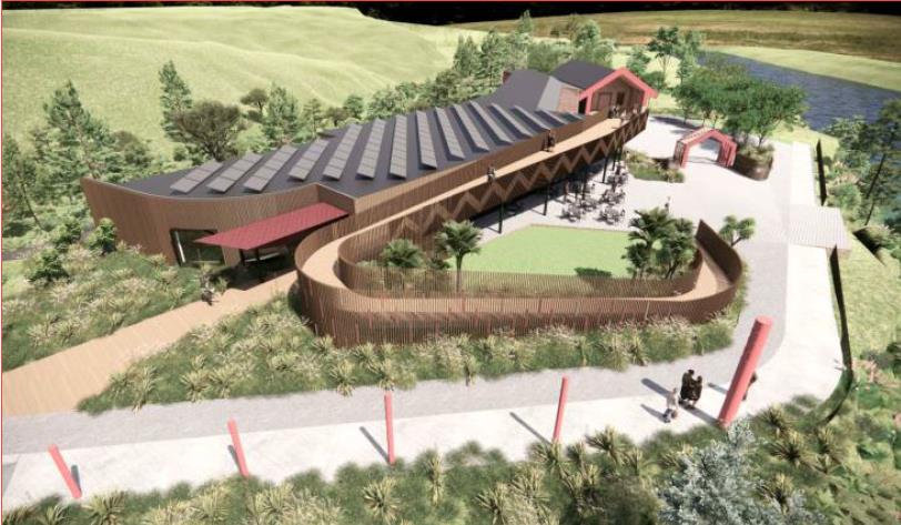
• Carparking and circulation area that allows for buses, motorhomes, cyclists and pedestrians – minimum 60
parking spaces.
• Services trenching from Vaucluse Heights for potable water, wastewater, electricity and fibre.
• 20,000 litre tank and pump for wastewater.
• 30,000 litre tank for potable water and fire hydrants.
• Three 30,000 litre tanks for stormwater. The stormwater is to be released into the existing natural water
course south of the site.
• Installation of fire hydrants.
• Installation of transformer.
• Clearance of existing vegetation at the site for the works to take place.
23/05/2025
• Landscaping at the site – including lawn areas, reinforced grass, garden beds, plantings and hangi pits.
S Dixon
M
to
- released
Figure 2: Design of the proposal (Concept Design Report).
SRC0280925
LGOIMA
5-P1569.FB
WSP
Te Motu o Poutoa - Ecology
6 March 2025
Desktop Assessment
3
Palmerston North City Council
2
ECOLOGICAL ASSESSMENT
METHODOLOGY
The overall approach used to undertake the ecological impact assessment involved application of the
“Guidelines for undertaking Ecological Impact Assessments (EcIA) published by the Environment Institute of
Australia and New Zealand (EIANZ, 2018)” using data and ecological information gathered by two primary
methods:
• A desktop review of existing data and ecological information.
• A site visit was undertaken by senior ecologist Melanya King on the 21st of February 2025.
23/05/2025
2.1
DESKTOP ASSESSMENT
The desktop assessment involved a review of relevant literature and databases. Information sources reviewed
as part of this assessment included:
• Aerial imagery and site photographs.
S Dixon
• Horizons Regional Council Planning Maps.
M
• The eBird NZ bird atlas.
to
• The DOC Bat Bioweb database.
• The Department of Conservation (DOC) Herpetofauna Bioweb database.
2.2
FIELD SURVEY
A field assessment was undertaken on 21 Feb 2025 to assess the ecological values of the vegetation for
- released
removal and the habitat it provides for fauna utilising the wider area. The following assessments were
undertaken:
• Identification of plant species, and an assessment of habitat suitability for threatened species.
• An incidental bird survey was undertaken, where all bird species observed and heard were recorded
for the duration of the site visit.
• Habitat assessments for lizards, including a brief manual search for lizards.
• Vegetation was assessed for bat roost features. Vegetation considered to be ‘high risk’ bat roosting
habitat are those >15 cm diameter at breast height (DBH) and have one or more of the following
SRC0280925
characteristics:
- Cracks, crevices, cavities, fractured limbs, or other deformities, large enough to support
roosting bats;
- Sections of loose flaking bark large enough to support roosting bats;
- A hollow trunk, stem or branches;
LGOIMA - Deadwood in the canopy or stem of sufficient size to support roost cavities or hollows.
5-P1569.FB
WSP
Te Motu o Poutoa - Ecology
6 March 2025
Desktop Assessment
4
Palmerston North City Council
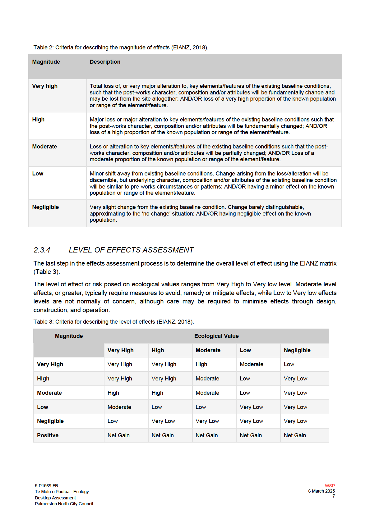
2.3
EIANZ GUIDELINES
2.3.1
EIANZ GUIDELINES
Guidelines for undertaking Ecological Impact Assessments (EcIA) published by the Environment Institute of
Australia and New Zealand (EIANZ, 2018) were used to assess the ecological impacts of the vegetation
clearance and habitat loss. These guidelines assist in assessing values and effects in a consistent and
transparent way. However, sound professional judgement is still required when applying this framework.
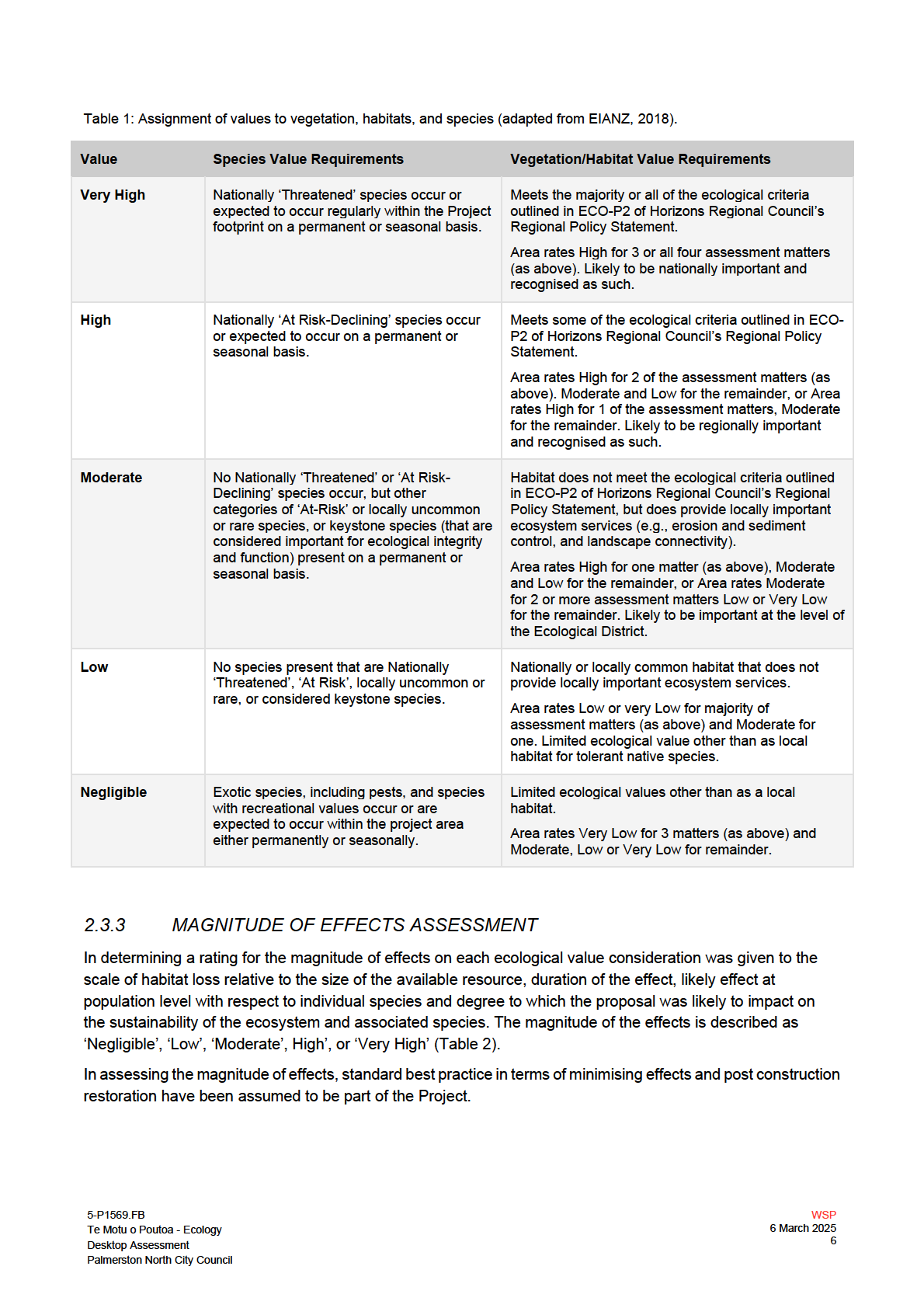
The approach involves assigning values for vegetation, habitats or species using the criteria in Table 1 and
then assigning a magnitude of effects rating using the criteria in Table 2. An overall level of effects is then
determined by combining the value of an ecological feature or attribute (Table 1) with the rating for the
magnitude of effect (Table 2) using the matrix in Table 3.
23/05/2025
2.3.2
ECOLOGICAL VALUES ASSESSMENT
The first step of the EcIA guidelines approach requires ecological values to be assigned on a scale of ‘Low’,
‘Moderate’, ‘High’, or ‘Very High’ to each ecological feature (Table 1).
Vegetation and habitat were valued using ECO-P2 of the Horizons Regional Council’s Regional Policy
S Dixon
Statement (Horizons Regional Council, 2001) in conjunction with the four key ‘matters’ to consider from the
EIANZ guidelines.
M
ECO-P2 covers the criteria outlined in Schedule 6, this provides criteria for determining the intrinsic
to
significance of an area of vegetation or habitat within the Horizons Region.
The EIANZ guidelines provide guidance on four key matters for consideration when assigning ecological value
or importance to a site or area of vegetation/habitat/community. These are:
• Representativeness.
• Rarity/distinctiveness.
•
- released
Diversity and pattern.
• Ecological context.
More information on these matters and how they are applied to assign value ecological features can be found
within Table 4 of the EIANZ guidelines. Scoring for sites or areas combining values for the four matters can be
found within Table 6 of the EIANZ guidelines (EIANZ, 2018). The key matters provide a basis for refining an
assessment of values for sites which meet the Schedule 6 criteria and for determining values in cases where
areas of vegetation or habitat does not meet the Schedule 6 criteria. The application of the four key matters to
consider is discussed in more detail in the relevant sections below.
The value of vegetation or habitat at the species level used conservation status as a starting point for
SRC0280925
determining value; the presence of those species classified as ‘At Risk’ or ‘Threatened’ conveying a higher
value than those classified as ‘Not Threatened’. Threat classifications have been sourced as follows: bats
(O’Donnell et. al., 2018); birds (Robertson et al., 2021); herpetofauna (Hitchmough et al., 2021); and plants
(de Lange et al., 2018).
In determining the value of vegetation/habitat (based on threat classification of species), the likelihood of
species being present and the importance of the habitat to the species based on habitat quality has also been
LGOIMA
considered. Note that in assigning value based on species, a site may support a high value species on
occasion but may have low value for a species based on habitat quality and the degree to which the species
relies on it in the context of the wider habitat resource it uses.
5-P1569.FB
WSP
Te Motu o Poutoa - Ecology
6 March 2025
Desktop Assessment
5
Palmerston North City Council
23/05/2025
S Dixon
M
to
- released
SRC0280925
LGOIMA
23/05/2025
S Dixon
M
to
- released
SRC0280925
LGOIMA
3
ASSESSMENT OF ECOLOGICAL
VALUE
3.1
SITE OVERVIEW
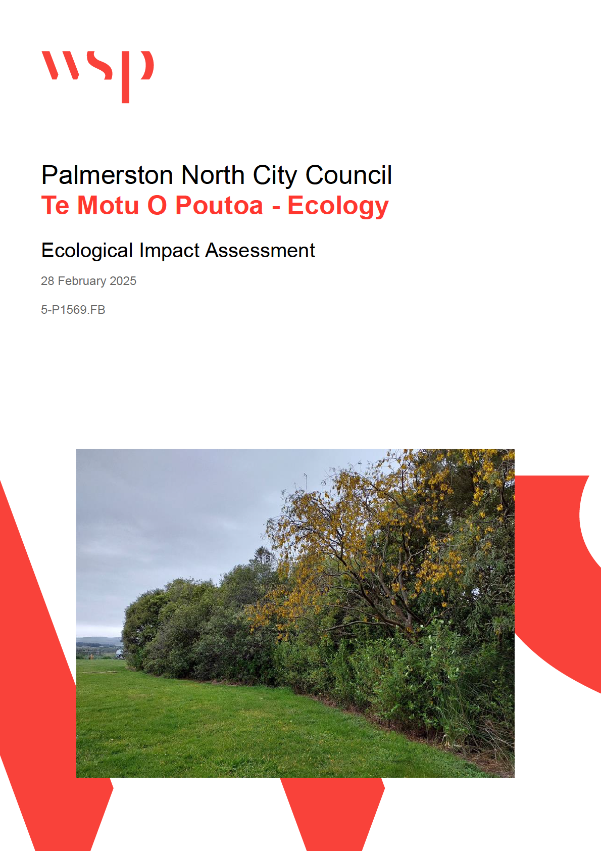
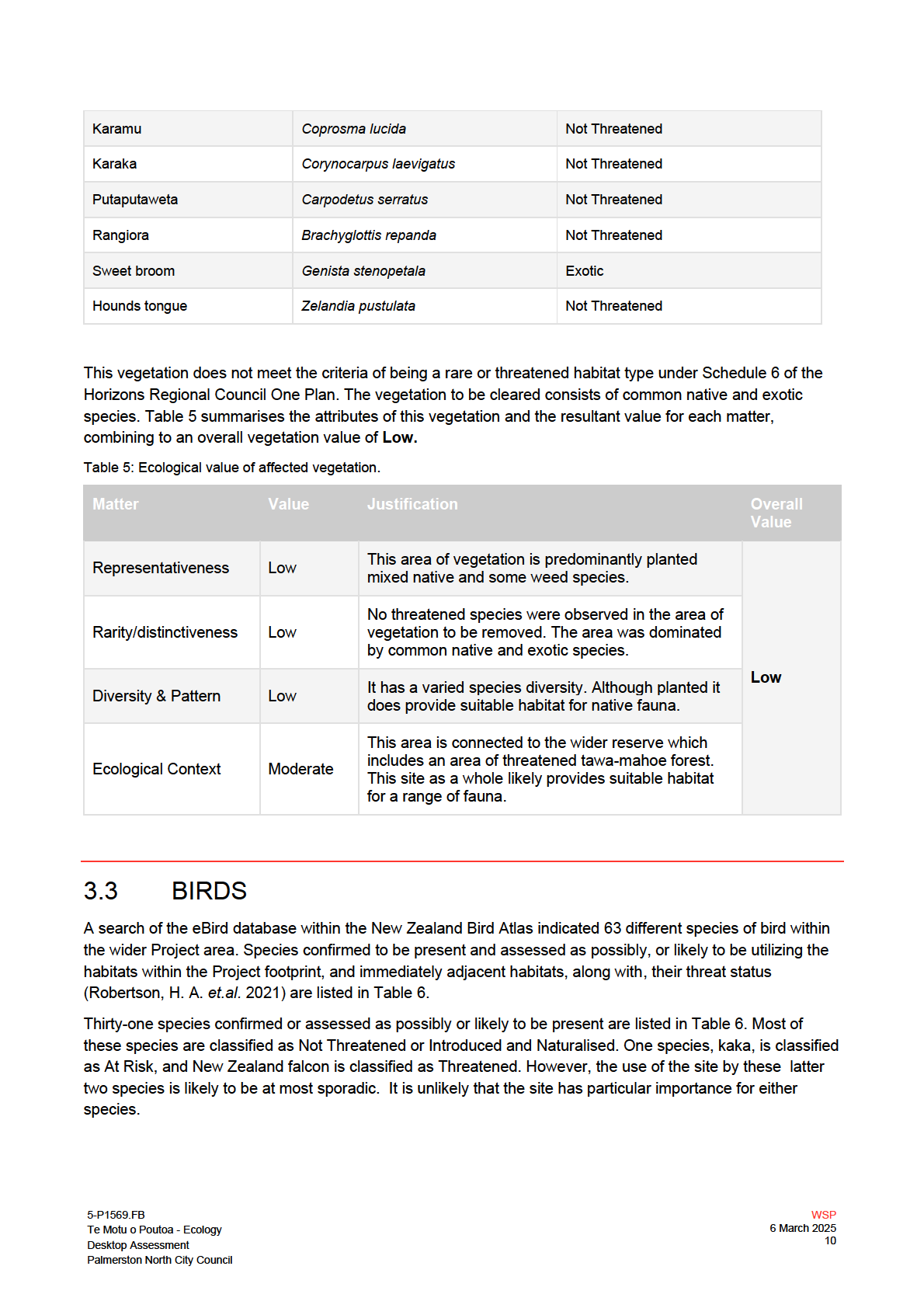
This assessment focuses on the 1685m2 of vegetation to be cleared for the project. The values of this habitat
are determined below as are its value as habitat for native fauna within the wider area. No wetlands or
watercourses were identified within the area of vegetation and as such are not discussed further. Photos of
the vegetation to be removed are provided below in Figure 3.
23/05/2025
S Dixon
M
to
- released
SRC0280925
Figure 3: Site photos of vegetation to be removed.
LGOIMA
3.2
VEGETATION
The vegetation surrounding the proposed development area was split into four separate vegetated blocks
(Figure 3). Each of these vegetated blocks are described in detail in the Schedule 6 Assessment Report
(WSP, 2024).
5-P1569.FB
WSP
Te Motu o Poutoa - Ecology
6 March 2025
Desktop Assessment
8
Palmerston North City Council
23/05/2025
S Dixon
M
to
- released
SRC0280925
LGOIMA
23/05/2025
S Dixon
M
to
- released
SRC0280925
LGOIMA
23/05/2025
S Dixon
M
to
- released
SRC0280925
LGOIMA
23/05/2025
S Dixon
M
to
- released
SRC0280925
LGOIMA
23/05/2025
S Dixon
M
to
- released
SRC0280925
LGOIMA
4
ASSESSMENT OF ECOLOGICAL
EFFECT
4.1
VEGETATION
The main impact on vegetation is the clearance of native amenity planting to accommodate the Project
footprint. The vegetation to be impacted by the proposal is of
Low ecological value, it comprises of common
native and exotic species. No threatened species were noted during either site visit in the area of vegetation to
be cleared.
23/05/2025
This vegetation is part of a wider block of vegetation of which a small proportion likely meets the criteria for
being a Schedule 6 habitat. However, the vegetation to be cleared (1685m2) is a small proportion of the wider
area (approximately 12%). Therefore, the magnitude of effect has been assessed as
Moderate. This results in
an overall ecological value of
Low.
It is not expected that there are going to be any residual adverse effects. Should the project wish to provide a
biodiversity net gain, pest plant control to be undertaken in the wider vegetated area.
S Dixon
M
4.2
BIRDS
to
The main effect on birds is the loss of native amenity planting for common native and introduced species. The
area of vegetation lost represents a very small proportion of the available habitat resource for these species in
the local landscape. Based on this the magnitude of effect has been assessed as
Negligible. This results in
an overall level of effect of Very Low.
While from an RMA perspective the overall level of effects on birds has been assessed as
Very Low, almost
all native bird species are protected from killing or disturbance under the Wildlife Act 1953 (Wildlife Act) (New
Zealand Government, 2022). In practice, for most bird species, most of the time, the risk of killing or
- released
significantly disturbing birds during site clearance is while nesting. It is therefore recommended that all
reasonable steps are taken to avoid or minimise the risk of killing or disturbing nesting birds during vegetation
and site clearance, thereby minimising the risk of committing an offence under the Wildlife Act.
4.3
LIZARDS
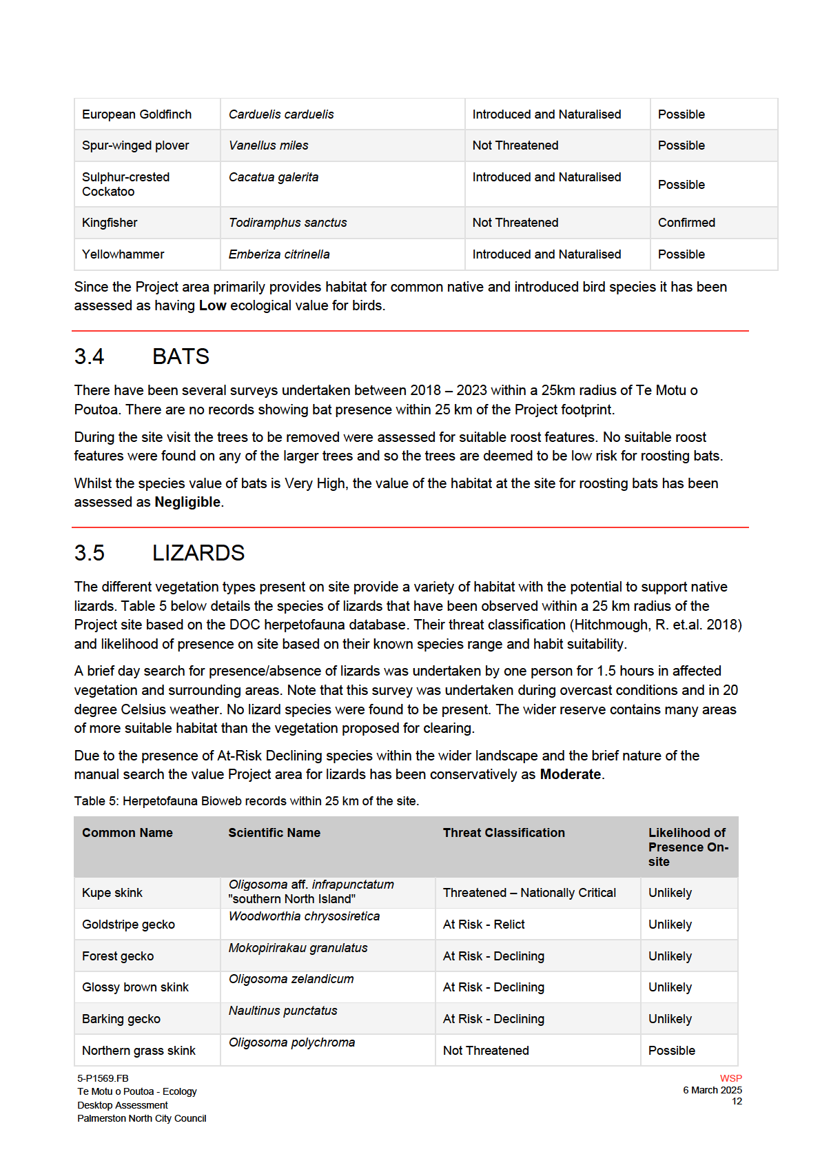
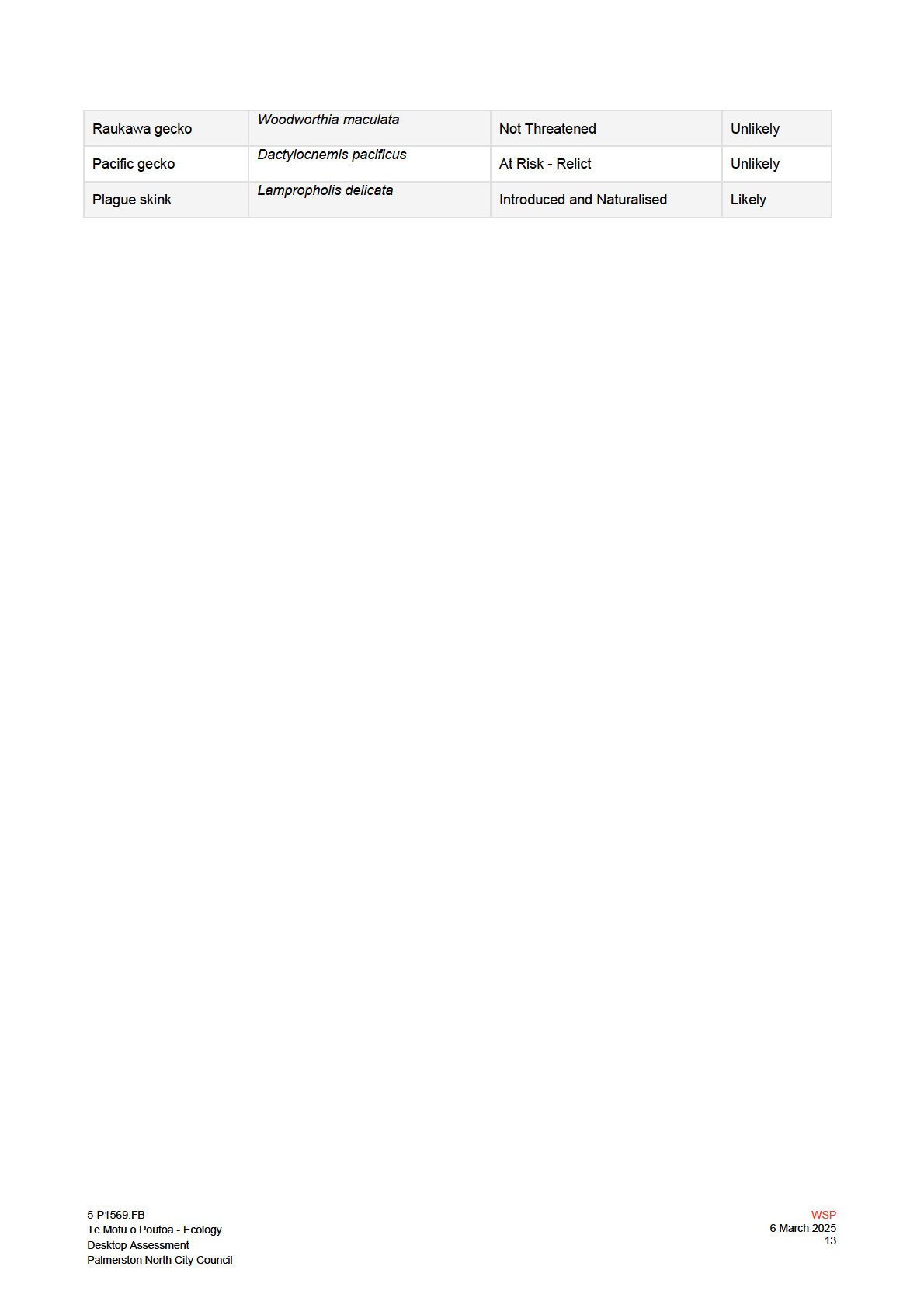
Records from the Bioweb Herpetofauna Database show historical records for native lizards and geckos within
25 km of the site. Due to the presence of At-Risk species within the wider landscape and the brief nature of
the manual search the value for lizards is conservatively considered to be
Moderate. The magnitude of effect
SRC0280925
for the vegetation loss is expected to be
Low, based on the likelihood of only common species being present,
the lack of suitable skink habitat (very little understorey vegetation and no areas of rank grass) and the very
small proportion of the total habitat resource in the locality. The overall level of effect is expected to be
Low.
While from an RMA perspective the overall level of effects on lizards has been assessed as
Low lizards are
protected from killing or disturbance under the Wildlife Act 1953 (Wildlife Act) (New Zealand Government,
2022). Robust passive management is recommended (to reduce the risk of harm/death to native lizards).
LGOIMA
5-P1569.FB
WSP
Te Motu o Poutoa - Ecology
6 March 2025
Desktop Assessment
14
Palmerston North City Council
4.4
BATS
Whilst the species value of bats is
Very High due to their threat status the value of the affected bat habitat
was assessed as
Negligible due to an absence of roost trees and the negative results from surveys within
25km indicating a likely absence of bats in the locality. Therefore, the magnitude of effects of the loss of this
habitat is
Very Low, resulting in an overall ecological effect of
Very Low.
23/05/2025
S Dixon
M
to
- released
SRC0280925
LGOIMA
5-P1569.FB
WSP
Te Motu o Poutoa - Ecology
6 March 2025
Desktop Assessment
15
Palmerston North City Council
5
RECOMMENDATIONS
A summary of the recommended measures proposed to minimise the effects of the Project are given below.
These measures address disturbance to wildlife during the construction period, likely effects of earthworks
activities and measures to reduce the mortality of birds and herpetofauna.
5.1
BIRD MANAGEMENT
• Native birds and their eggs are absolutely protected under the Wildlife Act 1953; therefore, vegetation
removal should occur outside of bird nesting season (August to February).
• If nesting season cannot be avoided, then a pre-removal nest inspection should be conducted by a
23/05/2025
suitably qualified ecologist. Occupied nest must be left in place until chick have fledged.
5.2
BAT MANAGEMENT
No potential bat roosts are present within the vegetation to be cleared on-site therefore no bat related vegetation
removal protocols apply.
S Dixon
M
5.3
LIZARD MANAGEMENT
to
Passive lizard management protocols are to be implemented prior to earthworks and vegetation clearance
within the Project footprint. Options include:
• Cutting rank grass (where applicable) within the Project site to a height of 100-150 mm at least 48
hours prior to earthworks. Rake the cut grass to areas outside the impact area. This will remove lizard
habitat within the area and encourage lizards to move outside of the impact area where cover objects
remain.
- released
• The project footprint shall be maintained as bare earth throughout the full duration of the construction
works to avoid any lizard species recolonising the area.
• Woody vegetation can be cut and left on-site for 24 - 48 hours to give native lizards the opportunity to
evacuate the area prior to removal from the site.
o If possible cut woody vegetation should remain on site and be relocated to within the wider
vegetated are.
• If lizards are observed during construction works should cease immediately and a qualified
herpetologist should be consulted.
SRC0280925
LGOIMA
5-P1569.FB
WSP
Te Motu o Poutoa - Ecology
6 March 2025
Desktop Assessment
16
Palmerston North City Council
6
CONCLUSIONS
This ecological impact assessment has determined that the Project site (and its receiving environments)
provides
Moderate to
Low value for fauna. The remaining ecological values for the site have been assessed
as
Low-Moderate. The mitigated level of effects of the proposed vegetation clearance have been assessed
and range from
Low to
Very Low.
Measures to mitigate any residual effects have been recommended, these include fauna management to
minimise the risk of harm to native species inhabiting the area. The proposed vegetation clearance is
expected to result in an overall ecological effect of
Low.
23/05/2025
S Dixon
M
to
- released
SRC0280925
LGOIMA
5-P1569.FB
WSP
Te Motu o Poutoa - Ecology
6 March 2025
Desktop Assessment
17
Palmerston North City Council
REFERENCES
Department of Conservation (DOC). Retrieved 2023. Ecological regions and districts of New Zealand.
New Zealand Topographical Map. NZMS 242 - sheet 2. Found online at:
ecological_regions_maps.pdf (doc.govt.nz)
Department of Conservation (DOC). (2021). Protocols for minimising the risk of felling bat roosts.
The New
Zealand Department of Conservation’s Bat Recovery Group. Version 2.
Environmental Institute of Australia and New Zealand Inc. (EIANZ) (2018). Environmental Impact Assessment
(EcIA): EIANZ guidelines for use in New Zealand: terrestrial and freshwater ecosystems 2nd Edition.
EIANZ, Melbourne, Australia.
Hitchmough, R. Barr, B. Knox, C. Lettink, M. Monks, J. Patterson, G. Reardon, J. van Winkel, D. Rolfe, J.
23/05/2025
Michel, P. (2021): Conservation status of New Zealand reptiles, 2021. New Zealand Threat
Classification Series 35.
Department of Conservation, Wellington. 15 p
Horizons Regional Council (2014). One Plan – The Consolidated Regional Policy Statement, Regional Plan
and Regional Coastal Plan for the Manawatu-Whanganui Region.
Horizons Regional council,
Palmerston North, New Zealand.
S Dixon
O’Donnell, C. Borkin, K. Christie, J. Lloyd, B. Parsons, S. Hitchmough, R. (2018). Conservation status of New
M
Zealand bats, 2017.
New Zealand Threat Classification Series 21, Department of Conservation,
Wellington, New Zealand.
to
WSP (2024)
Te Motu o Poutoa: Ecology Schedule 6 Assessment. Report prepared for Palmerston North City
Council.
- released
SRC0280925
LGOIMA
5-P1569.FB
WSP
Te Motu o Poutoa - Ecology
6 March 2025
Desktop Assessment
18
Palmerston North City Council