

Wider Surveillance for exotic
Caulerpa in Northland
C0036060
link to page 3 link to page 3 link to page 3 link to page 4 link to page 4 link to page 4 link to page 4 link to page 4 link to page 4 link to page 4 link to page 4 link to page 4 link to page 4 link to page 7 link to page 7 link to page 7 link to page 7 link to page 8 link to page 8 link to page 10 link to page 10 link to page 10 link to page 10 link to page 11 link to page 11 link to page 11 link to page 11 link to page 11 link to page 11 link to page 11 link to page 12
Contents
Introduction ........................................................................................................................................................... 3
Background ........................................................................................................................................................ 3
Contract objectives ............................................................................................................................................ 3
Figure 1. Potential anchoring events along the Northland coast of vessels that had departed locations
with known populations of exotic Caulerpa (blue circles) within the 10 previous days. Nodes where
potential anchoring events occurred (red circles) are sized according to their relative risk, i.e. the
proportion of the total number of Northland anchorage events that occurred at each location. Left
panel is for the Automatic Identification System (AIS) data network and the right panel for the Survey
data network. Source: Floerl O, Hilliam K, Faubel C, Stevenson S, Treml E. 2023. Prioritising surveillance
sites for exotic Caulerpa in Northland. Nelson: Cawthron Institute. Cawthron Report 3952. Prepared
for Northland Regional Council. ................................................................................................................ 4
Methods ................................................................................................................................................................. 4
Location selection .............................................................................................................................................. 4
Figure 2. Exotic Caulerpa diver-based transect surveillance from Whangaroa Harbour to the Bay of
Islands harbour, including various islands completed between 15th April to 28th April and 13th May to
16th May. Transects with exotic Caulerpa detected are in orange, transects without exotic Caulerpa
detected are in
blue……………………………………………………………………………………………………………………………………….5
Figure 3. Exotic Caulerpa diver-based transect surveillance from Tutukākā Harbour, Whangārei
Harbour and the Hen and Chicken Islands conducted between 1st May and the 12th of May 2024. No
exotic Caulerpa was detected in these
areas………………………………………………………………………………………………………………………………….….6
Surveillance methodology .................................................................................................................................. 7
Results .................................................................................................................................................................... 7
Table 1. Number and length of delimitation survey transects conducted per month between May and
April 2024, and the presence of exotic Caulerpa found during these surveys. ......................................... 7
Table 2. Number of transects completed each day at each location between 15th April and 16th May
2024 (n = 382). ........................................................................................................................................... 8
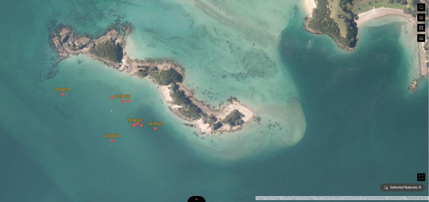
Figure 4. (A) Map of the locations where benthic mats were placed on exotic Caulerpa infestations
around Poroporo Island, Bay of Islands. Dates correspond to when the benthic mats were placed. Red
dots indicate where patches of exotic Caulerpa were found, and numbers indicate benthic mats were
placed (Table 3) (n = 6). (B - E) Exotic Caulerpa patches found at Poroporo Island. ............................... 10
Table 3. Summary of benthic treatments undertaken on April 24th 2024 for exotic Caulerpa
infestations near Poroporo Island, Te Rāwhiti, Bay of Islands (n = 6). Site labels correspond to Figure 4.
................................................................................................................................................................. 11
Figure 5. Images from Commercial Dive Specialists (CDS) of Ulva sp. from Whangārei Heads area on
6th May 2024. Photo on the left shows the algae in situ and photo on the right shows the algae out of
the water. ................................................................................................................................................ 11
Discussion ............................................................................................................................................................. 11
Contract objectives revisited ............................................................................................................................ 12
2
C0036060 Wider Surveillance in Northland
Introduction
Background
On 5th July 2021 Biosecurity New Zealand (BNZ) was notified about, and subsequently identified, the
invasive alga
Caulerpa brachypus at Aotea/Great Barrier Island. Delimiting surveys confirmed
populations in three locations on the southwestern side of the island (Blind Bay, Tryphena Harbour,
and Whangaparapara Harbour). On 15th March 2022 four populations of
Caulerpa brachypus and
Caulerpa parvifolia (hereon referred to as ‘exotic Caulerpa’) were discovered at two locations on the
western side of Ahuahu/Great Mercury Island, and the response was extended to include this island.
In May 2023 BNZ were notified about, and subsequently identified, exotic Caulerpa in several locations
surrounding Te Rāwhiti inlet, Omākiwi Cove, and into Albert Channel, Bay of Islands (Te Rāwhiti and
Northland response).
As exotic Caulerpa is most likely spread via entanglement in or attachment to anchors, it is possible
that populations of exotic Caulerpa are present in other locations which have not yet been surveyed.
The Northland Regional Council (NRC) and BNZ consequently recognized the need to conduct wider
surveillance for exotic Caulerpa across well-known anchorages throughout the Northland region.
Prior to the discovery of exotic Caulerpa in Northland, but after discovery of infestations at
Aotea/Great Barrier Island and Ahuahu/Great Mercury Island, NRC and the Cawthron Institute
obtained a medium Envirolink grant (reference 2343-NLRC238). This grant supported a project that
mapped a connectivity network between known infestation sites in Northland, and identified
potential anchoring hotspots that were accessible within 10 days of a vessel visiting a known
infestation site (10 days is the assumed survival period of exotic Caulerpa fragments; Fig. 1). This data
informed the locations of interest to be surveyed as part of this contract.
Contract objectives
-
Provide an Operational Specification and Health & Safety Management Plan and a Ministry
for Primary Industries (MPI) Health & Safety Questionnaire.
-
Complete dive surveillance for exotic Caulerpa at high-risk sites in Northland.
-
Provide access to ArcGIS platform for live data for BNZ contract manager.
-
Provide a written report of findings from dive surveillance, including:
o Achievement of each contract objective.
o Effectiveness of the surveillance programme logistics, costs, cultural considerations,
etc.
o Any other conclusions or results relevant to the project goal or objectives.
3
C0036060 Wider Surveillance in Northland
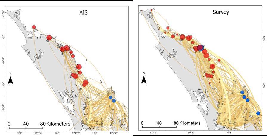 Figure 1. Potential anchoring events along the Northland coast of vessels that had departed locations with known
populations of exotic Caulerpa (blue circles) within the 10 previous days. Nodes where potential anchoring events occurred
(red circles) are sized according to their relative risk, i.e. the proportion of the total number of Northland anchorage events
that occurred at each location. Left panel is for the Automatic Identification System (AIS) data network and the right panel for
the Survey data network. Source: Floerl O, Hilliam K, Faubel C, Stevenson S, Treml E. 2023. Prioritising surveillance sites for
exotic Caulerpa in Northland. Nelson: Cawthron Institute. Cawthron Report 3952. Prepared for Northland Regional Council.
Methods
Location selection
Survey areas were identified as popular anchorages throughout the Northland region using the
following knowledge sources (in no particular order):
-
Floerl, O., Hilliam, K., Faubel, C., Stevenson, S. and Treml, E. (2023) Prioritising surveillance
sites for exotic Caulerpa in Northland.
Cawthron Institute Report 3952, prepared for Northland
Regional Council.
-
Local knowledge from skippers.
-
BNZ Marine High Risk Site Surveillance maps.
Areas were surveyed from the Hen and Chicken Islands near Whangārei harbour, up to the Cavalli
Islands and Whangaroa Harbour (Figs 2 and 3). The Hen and Chicken Islands were included in this
surveillance work following the discovery of exotic Caulerpa at Rākino Island and the Mokohinau
Islands in Auckland.
4
C0036060 Wider Surveillance in Northland
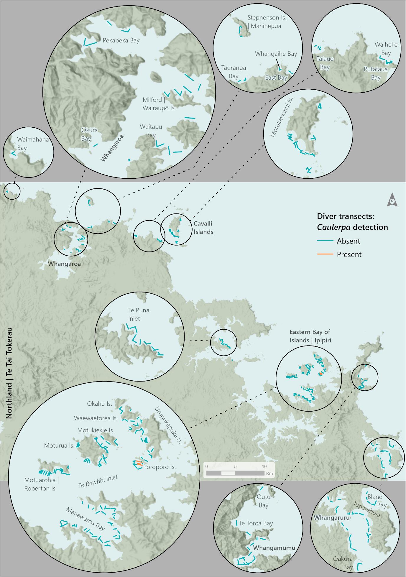 Figure 2. Exotic Caulerpa diver-based transect surveillance from Whangaroa Harbour to the Bay of Islands harbour, including
various islands completed between 15th April to 28th April and 13th May to 16th May. Transects with exotic Caulerpa detected
are in orange, transects without exotic Caulerpa detected are in blue.
5
C0036060 Wider Surveillance in Northland
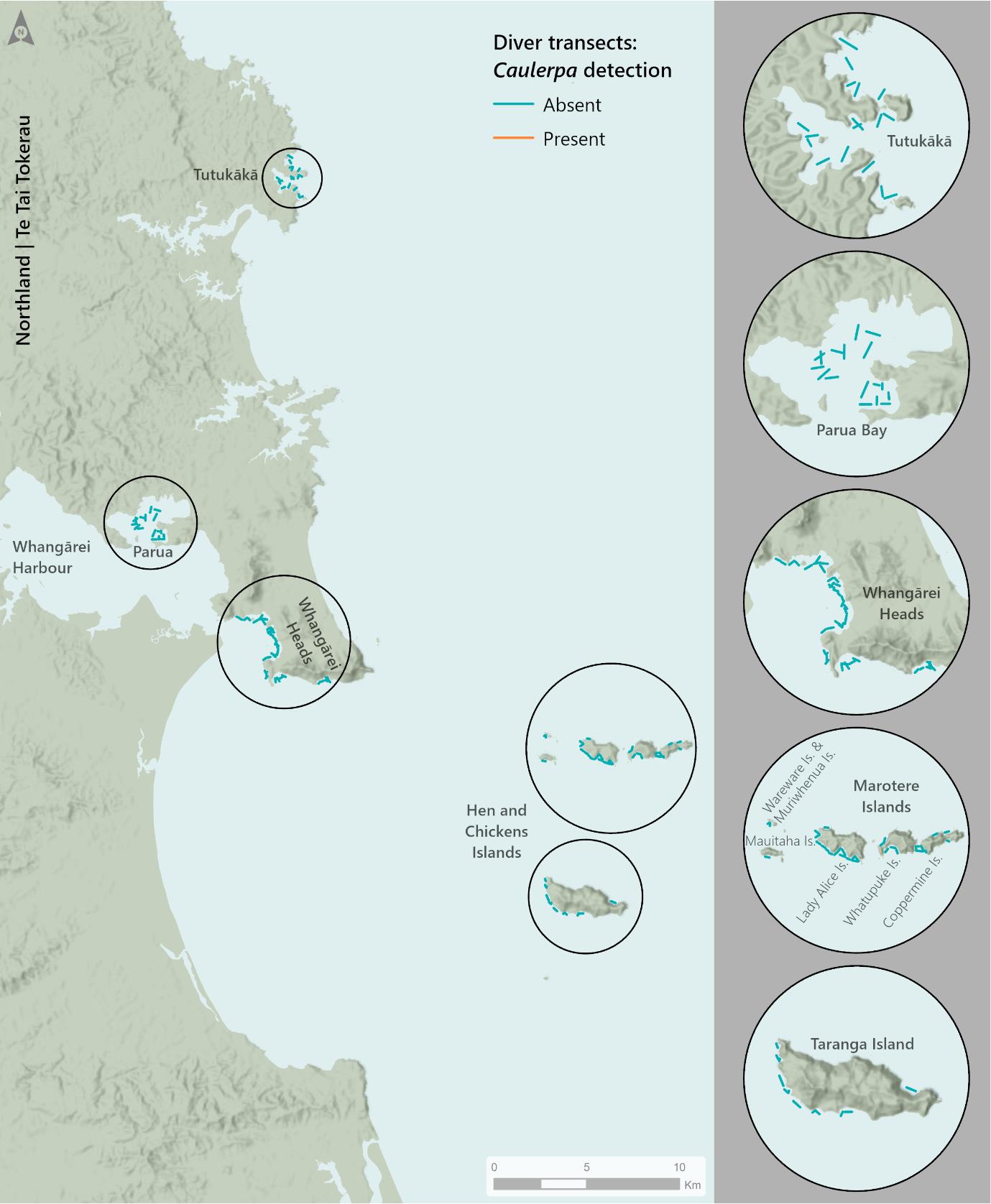 Figure 3. Exotic Caulerpa diver-based transect surveillance from Tutukākā Harbour, Whangārei Harbour and the Hen and
Chicken Islands conducted between 1st May and the 12th of May 2024. No exotic Caulerpa was detected in these areas.
6
C0036060 Wider Surveillance in Northland
Surveillance methodology
Surveillance was conducted between 15th April 2024 to 16th May 2024. All diving was completed by
Commercial Dive Specialists (CDS) Ltd who have experience conducting exotic Caulerpa surveillance
alongside NRC staff and have been involved in benthic matting operations at Waiheke Island,
Auckland.
Divers followed a predetermined bearing for 15 minutes and systematically scanned the seafloor for
exotic Caulerpa. The area searched was calculated using the length of the transect swum, and assumed
divers could effectively search to a width of 2m (1m either side). If exotic Caulerpa was found, the
diver informed the surface attendant either by surfacing or by using a surface float to signal presence.
The surface attendant recorded the GPS position on NRC’s ArcGIS FieldMaps platform, which is
accessible to BNZ staff. The relatively shallow depth of anchorages (<10m) allowed for multiple sites
to be searched daily without depth related restrictions or issues arising from bounce diving.
Dive operations were conducted in a manner that ensured minimum contamination between dive
sites to prevent the spread of exotic Caulerpa. Diving was not undertaken in areas where exotic
Caulerpa was not known to be present directly after diving in infested areas. After each dive day that
exotic Caulerpa was detected, NIWA’s decontamination protocols were followed for all dive and
survey gear (soaked in a detergent and freshwater solution).
Results
Divers spent 27 days conducting surveillance around 25 harbours and bays and 19 islands/island
groups within the Northland region, swimming 93.3 km and searching approximately 186,600 m2(Figs
2 and 3; Tables 1 and 2).
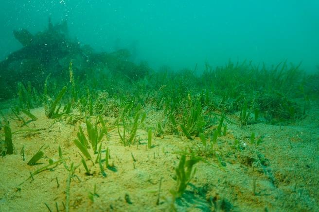
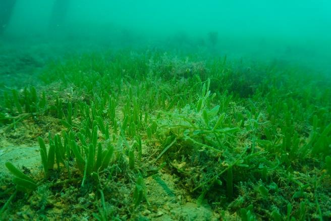
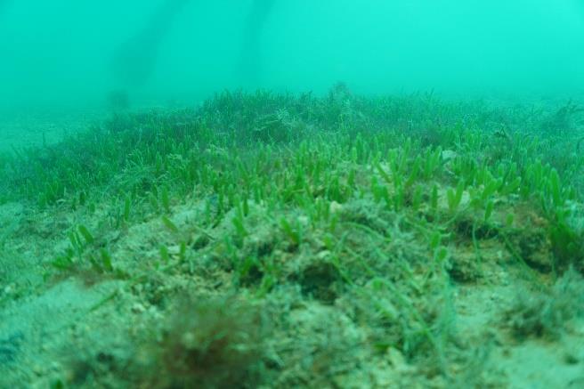
Exotic Caulerpa was identified at one of these locations; Poroporo Island, Te Rāwhiti Inlet, Bay of
Islands (Fig. 2; Table 2). This island is within the boundary of the Controlled Area Notice (CAN) zone.
Benthic mats with chlorine tablets were placed over six infestations at this site (Fig. 4; Table 3).
Table 1. Number and length of delimitation survey transects conducted per month between May and April 2024, and the
presence of exotic Caulerpa found during these surveys.
Transects with
Transects with
Approximate area
Month
Transect count
Total length (km)
exotic Caulerpa (#)
exotic Caulerpa (%)
searched (m2)
April 2024
226
55.2
4
1.76
110,400
May 2024
156
38.1
0
0
76,200
TOTAL
382
93.3
4
1.04
186,600
7
C0036060 Wider Surveillance in Northland
Table 2. Number of transects completed each day at each location between 15th April and 16th May 2024 (n = 382).
Date
Location
Specific location
Number of transects
Substrate
Notes
15/04/2024
Bay of Islands
Manawaora Bay
19
Mud, sand
16/04/2024
Cavalli Islands
Papatara Bay
2
Sand, gravel
16/04/2024
Cavalli Islands
Motukawanui Island
5
Reef, sand, shell, gravel
16/04/2024
Cavalli Islands
Kahangaro Island
6
Sand, shell, gravel
16/04/2024
Matauri Bay
Putataua Bay
8
Reef, sand
17/04/2024
Cavalli Islands
Motukawanui Island
17
Sand, shell, gravel, reef
17/04/2024
Whangamumu Harbour
Whangamumu Harbour
1
Sand
18/04/2024
Whangamumu Harbour
Whangamumu Harbour
14
Sand, reef
18/04/2024
Te Toroa Bay
Te Toroa Bay
2
Sand, reef
18/04/2024
Outu Bay
Outu Bay
1
Sand
18/04/2024
Bay of Islands
Manawaora Bay
1
Sand, mud, shelly gravel
19/04/2024
Bay of Islands
Manawaora Bay
15
Sand, mud, shell, gravel
19/04/2024
Bay of Islands
Motuarohia Island
2
Sand
20/04/2024
Bay of Islands
Motuarohia Island
18
Sand
21/04/2024
Bay of Islands
Moturua Island
19
Sand, shell, gravel
22/04/2024
Bay of Islands
Moturua Island
7
Sand, gravel, reef
22/04/2024
Bay of Islands
Motukiekie Island
4
Sand, gravel
22/04/2024
Bay of Islands
Okahu Passage
3
Sand, gravel
22/04/2024
Bay of Islands
Waewaetorea Island
3
Sand, shell, gravel, reef
22/04/2024
Bay of Islands
Urupukapuka Island
1
Sand
23/04/2024
Bay of Islands
Waewaetorea Island
3
Sand, shell, gravel, reef
23/04/2024
Bay of Islands
Urupukapuka Island
14
Sand
24/04/2024
Bay of Islands
Urupukapuka Island
2
sand
24/04/2024
Bay of Islands
Poroporo Island
12
Sand, shell, gravel
Exotic Caulerpa found.
25/04/2024
Bay of Islands
Poroporo Island
5
Sand, shell, gravel
Exotic Caulerpa patches marked, and 6 benthic mats
placed (Fig. 4).
25/04/2024
Bay of Islands
Urupukapuka Island
5
Sand
26/04/2024
Kerikeri Inlet
Te Puna Inlet
14
Mud, shell, gravel
27/04/2024
Whangaruru Harbour
Whangaruru Harbour
15
Sand, mud
27/04/2024
Whangaruru Harbour
Tuparehuia Bay
7
Sand, mud
28/04/2024
Whangaruru Harbour
Whangaruru Harbour
3
Sand, mud
28/04/2024
Whangaruru Harbour
Tuparehuia Bay
5
Sand, mud
28/04/2024
Whangaruru
Bland Bay
5
Sand
28/04/2024
Whangaruru South
Ōakura Bay
3
Sand
01/05/2024
Tutukākā Harbour
Tutukākā Beach
2
Shell, gravel, sand, reef
02/05/2024
Tutukākā Harbour
Tutukākā Harbour
15
Shell, gravel, sand, reef
03/05/2024
Whangārei Harbour
Parua Bay
9
Mud
Date
Location
Specific location
Number of transects
Substrate
Notes
03/04/2024
Whangārei Harbour
Whangārei Heads
7
Sand, mud, shell, gravel
04/05/2024
Hen and Chicken Islands
Whatupuke Island
5
Reef
04/05/2024
Hen and Chicken Islands
Coppermine Island
3
Reef
04/05/2024
Hen and Chicken Islands
Taranga Island
10
Sand, reef
05/05/2024
Hen and Chicken Islands
Mauitaha Island
1
Reef
05/05/2024
Hen and Chicken Islands
Lady Alice Island
15
Reef, sand
05/05/2024
Hen and Chicken Islands
Whatupuke Island
2
Reef
05/05/2024
Hen and Chicken Islands
Coppermine Island
2
Reef
05/05/2024
Hen and Chicken Islands
Wareware and Muriwhenua Islands
2
Reef
06/05/2024
Whangārei Harbour
Whangārei Heads
18
Reef, sand
Potential sighting of exotic Caulerpa, NRC identified this
to be Ulva sp. (Fig. 5).
07/05/2024
Whangārei Harbour
Whangārei Heads
17
Sand, shell, gravel
12/05/2024
Whangārei Harbour
Parua Bay
11
Sand, mud
13/05/2024
Whangaroa area
Mahinepua Bay
3
Sand, reef
NRC additional funding
13/05/2024
Whangaroa area
East Bay
2
Sand
NRC additional funding
13/05/2024
Whangaroa area
Whangaihe Bay
3
Sand, reef
NRC additional funding
13/05/2024
Whangaroa area
Taiaue Bay
4
Sand, reef
NRC additional funding
14/05/2024
Mahinepua Island
Mahinepua Island
4
Sand, reef
NRC additional funding
14/05/2024
Whangaroa Harbour
Pekapeka Bay
4
Sand, mud
NRC additional funding
14/05/2024
Whangaroa area
Tauranga Bay
3
Sand
NRC additional funding
14/05/2024
Whangaroa area
Waimahana Bay
2
Sand
NRC additional funding
14/05/2024
Whangaroa Harbour
Whangaroa Harbour
1
Sand, mud
NRC additional funding
16/05/2024
Whangaroa Harbour
Okura Bay
1
Sand, mud
NRC additional funding
16/05/2024
Whangaroa Harbour
Wairaupō Island
5
Sand. mud
NRC additional funding
16/05/2024
Whangaroa Harbour
Waitapu Bay
4
Sand, mud
NRC additional funding
16/05/2024
Whangaroa Harbour
Whangaroa Harbour
1
Sand, mud
NRC additional funding
TOTAL
382
9
C0036060 Wider Surveillance in Northland
(A)
Poroporo Island
1
2 3 4
5 6
(B)
(C)
(D)
(E)
Figure 4. (A) Map of the locations where benthic mats were placed on exotic Caulerpa infestations around Poroporo Island, Bay of Islands.
Dates correspond to when the benthic mats were placed. Red dots indicate where patches of exotic Caulerpa were found, and numbers
indicate benthic mats were placed (Table 3) (n = 6). (B - E) Exotic Caulerpa patches found at Poroporo Island.
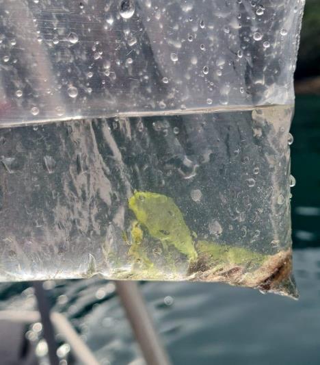
 Table 3. Summary of benthic treatments undertaken on April 25th 2024 for exotic Caulerpa infestations near Poroporo Island,
Te Rāwhiti, Bay of Islands (n = 6). Site labels correspond to Figure 4.
Mat
Mat Size (m)
Treatment
Mat depth (m)
Number
1
Benthic matting and chlorine
1 x 1
6.2
2
Benthic matting and chlorine
2 x 2
4.3
3
Benthic matting and chlorine
1 x 1
5.2
4
Benthic matting and chlorine
1 x 1
4.7
5
Benthic matting and chlorine
2 x 2
5.3
6
Benthic matting and chlorine
1 x 1
5.3
Figure 5. Images from Commercial Dive Specialists (CDS) of Ulva sp. from Whangārei Heads area on 6th May 2024. Photo on
the left shows the algae in situ and photo on the right shows the algae out of the water.
Discussion
No exotic Caulerpa was detected outside the Controlled Area Notice (CAN) in Te Rāwhiti, Bay of Islands
(Figs 2 and 3). However, there was a range extension within the boundaries of the CAN; divers found
small patches of exotic Caulerpa at a depth of 5 – 8 m along the western bay of Poroporo Island (Figs
2 and 4). This area had been searched 12 months earlier and no exotic Caulerpa was detected at that
time. Upon finding exotic Caulerpa in April 2024, divers placed six benthic mats with chlorine pucks
underneath the mats (within the guidelines of NRC’s resource consent AUT.036500.01.03 for using
chlorine to respond to marine pest incursions in Northland). Not all patches around Poroporo Island
were treated due to lack of weights used to secure the mats to the substrate.
Divers completed 93.3 kilometres of surveillance transects over 27 diving days, equating to
approximately $1,822 per kilometre swum, or $6,296 per day (using a combined budget of $170,000
11
C0036060 Wider Surveillance in Northland
all costs exclude GST). This contract provided an effective way to cover a lot of ground to search for
exotic Caulerpa – more so than what could be achieved by NRC divers or other government agencies.
It is highly recommended that this work is continued to ensure exotic Caulerpa does not spread
outside of the CAN. Further to survey effort, consistent presence of divers on the water also assisted
with compliance; divers were able to get in touch with hapū members to inform them of vessels
anchoring in the CAN.
A lot of diving effort was put into the surrounding Bay of Islands area and although this is still a popular
area for vessel movements and anchoring, and therefore a high-risk area, some of this effort should
have been distributed to conduct surveillance in Whangaroa harbour which is another popular
destination and anchoring area. Therefore, NRC provided additional budget to this surveillance
contract to ensure the Whangaroa area and surrounding bays were surveyed.
Contract objectives revisited
The completion of the contractual objectives are noted below in bold.
• Provide an Operational Specification and Health & Safety Management Plan and MPI H&S
Questionnaire.
COMPLETED PRIOR TO COMMENCING SURVEILLANCE.
• Complete dive surveillance of Northland high-risk sites for exotic Caulerpa.
COMPLETED
PRIOR TO THE WRITING OF THIS REPORT.
• Provide access to ArcGIS platform for live data for BNZ contract manager.
COMPLETED
PRIOR TO THIS CONTRACT AS PART OF NRC/BNZ PARTNERSHIP.
• Provide written report of findings from dive surveillance.
COMPLETE.
12
C0036060 Wider Surveillance in Northland

13
C0036060 Wider Surveillance in Northland