Rapid Transit in the Wellington regionDefinitions:
Commented [GF1]: I’ve elected to show both sources here
as it is the central government definitions that we have
The GPS and NPS-UD defines rapid transit as:
drawn here.
“A quick, frequent, reliable and high-capacity public transport service that operates on a permanent
Commented [AK2]: Sorry to be pedantic but this is not
route (road or rail) that is largely separated from other traffic.”
strictly true, as the NPS-UD definitions are aligned but
slightly different. I have suggested some alternative text.
The National Policy Statement for Urban Development (NPS-UD) shares the same definition for
Commented [an3R2]: Given the text below, it's worth
‘rapid transit service’, but extends it to “any existing or planned” service. “Planned” means planned
noting what that difference is.
in a regional land transport plan such as this pPlan.
Commented [an4]: Grant, I'm not sure what your
shorthand for this document is: "this plan", "the RLTP" etc -
The National Policy Statement on Urban DevelopmentNPS-UD introduces a new requirement for
feel free to standardise "this plan" to your preferred term.
Wellington’s regional policy statement, and the district plans of Wellington City, Hutt City, Upper
Commented [an5]: Amy and I had a good conversation
Hutt City, Porirua City and Kaāpiti Coast District, to enable building heights of at least 6 storeys
about how much detail we want to add here. For now, this is
within at least a walkable catchment of current and planned rapid transit stops. This means that
probably sufficient, and we may get a better picture through
consultation/submissions on the draft plan.
rapid transit identified in this pPlan has a connection to the land use controls in these Resource
Commented [GF6]: The basis for this is paragraph is the
Management Act (RMA) documents.
agreement in the draft Regional Growth Framework which
designates the rapid transit/core public transport network.
The NPS-UD also has directions to enable building heights and density commensurate to levels of
existing and planned public transport generally. This pPlan and the Wellington region’s RMA
Commented [AK7]: It would be good to see the
corresponding detail in the RPTP as I think this is the better
documents work together to enable more people, businesses and community services to be located
place to reference characteristics.
in areas well-serviced by existing and planned public transport.
Commented [GF8]: Check definition is here. Should it
s for intensification in areas close to current or planned rapid transit services and stops (as well as
read “Signgificatn Activities”
places where people can access many opportunities within walking distance), enabling good
Commented [GF9]: We’ll need to hyperlink to this section.
accessibility in areas that will be zoned for higher density.
Commented [AK10R9]: Could we indicate the relevant
activities somehow, eg, with asterix or an RT? It would also
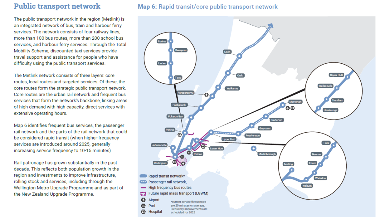
The rapid transit network and services for the Wellington region comprises the Kāpiti, Hutt, Melling
be helpful if the description of the activities noted any
and Johnsonville rail lines. and tThe proposed Mass Rapid Transit corridor network proposed in by
significant changes in service frequency.
the Let’s Get Wellington Moving (LGWM) programme (once the rapid transit network and stops are
Commented [an11]: I added this text to support the
confirmed) will also form part of this rapid transit network. will also form part of this rapid transit
eventual legal argument that, with the upgrades planned in
the RLTP, the rail lines meet the GPS and NPS-UD definitions
network. The LGWM rapid transit service will become “planned” for the purpose of the NPS-UD once
of rapid transit.
the Mass Rapid Transit corridor, and the location of the stops, are consented (under the RMA or
Commented [AK12]: is everyone comfortable with the
other legislation).
map below being used, or does it need any changes?
The rail lines are part of Metlink’s core public transport network. Plans to upgrade this network to
Commented [an13R12]: I think the Port icons at Petone
increase service frequency and capacity are contained in the GWWellington Regional Public
and LGWM could be removed or relocated. It won't be part
of the LGWM future mass rapid transit, at least not in the
Transport Plan and reflected in the Significant Activities section of this Plan’s programme of
timeframe of this RLTP. And Petone doesn't have a 'port'. It
activities. These upgrades will ensure that the rail services are “quick, frequent, reliable and high-
could be moved up to connect with the purple high
capacity" to enable greater intensification cater for housing and business growth around the rail
frequency bus route to reflect its location along Hutt Road ...
but this would still be more detail than needed.
stations. [could we include a summary statement about the change in service frequency that is
Unless you're meaning the inter-harbour ferry services? But
proposed eg, in a similar way to that in para 3 of the WRGF text below?] The Let’s Get Wellington
this isn't identified in the key either.
Moving Mass Rapid Transit corridor will be developed as part of that Let’s Get Wellington Moving
Commented [an14R12]: Also just checking ... is the RLTP's
programme.
plan to have a high frequency bus route to the airport, as
shown on the map? Or just a service every 20 minutes or so?
Urban intensification opportunities around public transport stops will be planned through the
Commented [AH15]: We have a map of the public
district plans of the Wellington region’s district and city councils.
transport network in the RLTP. Is the idea here that we also
link to the map of the public transport network in the
Insert map here:
WRGF?
Commented [AK16R15]: Yes, I think we need to have a
simple rapid transit map as the PT map very complex.