Assessment of geological heritage values and extent of
“volcanic remnants” within the Three Kings Precinct Plan
Bruce W. Hayward
Geomarine Research
Report BWH 183/17
October 2017
Summary
I have assessed the Environment Court evidence of two geologists Dr Lindsay and
Mr Hind, on the geoheritage values of features in the Three Kings precinct. I find that
they largely agree that all remnant features a-e are in man-made quarry faces containing
exposures of natural rock that are remnants of Three Kings Volcano. There are slight
differences in their respective assessments of the geoheritage values of these remnant
exposures but I suspect both would agree with my middle ground assessment of their
values. Both extensively discuss an additional feature, a remnant of the basalt lava lake
exposed in a cutting alongside Grahame Breed Drive (here named feature x) that has not
been listed as a feature to protect in the proposed listed features a-e.
I have compared the mapped extent of the features on Precinct Plan 1A with their
actual extent in the field. The western arm of feature b is a steep vegetated slope and not
an exposure and should be removed as having no geoheritage value. The mapped extent
of features a, c and d appear to be essentially correct. Feature e (lower lava lake) does not
underlie feature d in the southern wall of the quarry, but is in the lower part of the
southern end of the eastern wall. The mapped extent of this feature should be corrected or
the whole feature deleted altogether.
I assess the identified remnant volcanic features a and d, plus x, to have
significant local geoheritage value that warrant their long-term protection and periodic
vegetation clearance/spraying. Features a and x will pose no safety risks and will need no
management or structures related to this aspect. Feature d may pose a limited safety risk
in the future (> 5 years away) requiring a safety fence to keep people away from the base
of the exposure, if scoria erosion undercuts the solid lava lake basalt above.
I assess features b and c to be featureless faces of scoria that are being rapidly
covered in weedy vegetation. I assess their geoheritage value to be minimal except that
they provide evidence of some of the former extent (depth) of the South Cone. As such, I
do not believe that periodic vegetation clearance can be justified to keep them as
exposures of the underlying scoria, especially as it would increase instability and erosion
of the faces. Additionally I do not consider that they have sufficiently high geoheritage
values that can be used to justify their protection. I am not qualified to assess whether
they may have sufficient landscape, aesthetic or other values that might justify their long-
term protection as vegetated man-made bluffs, but they do need to be kept as exposures
of the rocks.
Feature e, lower lava lake, is now poorly exposed and its exact origins are
impossible to deduce and will be impossible to convincingly explain to the public. It
consists of a near-vertical exposure of solid basalt that will not readily weather, nor
1
become completely hidden by vegetation, nor pose a safety risk. As its location is
wrongly mapped, I suggest it be deleted completely from the list of remnant features and
be replaced by remnant feature x – remnant lava lake exposure in cutting beside widened
Grahame Breed Drive.
Features a, d and x will lend themselves to interpretative signage to explain their
importance as remnants of Three Kings Volcano.
Introduction
Auckland Council has received a proposal from Fletcher Residential Limited to
protect five features in the development of the former Three Kings Quarry.
I have been asked by Auckland Council to:
1. Review the two previous briefs of evidence regarding the remnant geological features
within the Three Kings precinct.
2. Visit the site, and assess the significance or value of these features, having regard to
the policies of the Auckland Unitary Plan.
3. Compare the actual location of these features with those indicated on precinct plan 1A
and modify if necessary.
4. Having completed the evaluation, assess whether the five remnant volcanic features
shown on precinct plan 1A should be afforded local recognition and protection in the
Three Kings precinct.
5. Prepare this report recording my evaluation and recommendations.
Auckland Volcanic Field
Auckland City is built over a young basalt volcanic field (200,000 to 600 yrs old)
that stretches from Pupuke in the north to McLaughlins Hill, Wiri, in the south. Fifty-three
volcanoes have erupted in the field,
Three Kings Volcano
Three Kings Volcano has been dated at about 30,000 years old, slightly older than its
neighbour Maungawhau/Mt Eden. The volcanic rocks seen around Three Kings and
especially in exposures in and around the explosion crater suggest the following sequence
of eruptive events:
1. Explosive (wet phreatomagmatic) eruptions were the initial phase of volcanism. These
eruptions occurred when rising magma encountered ground water, producing
superheated steam. Gases dissolved in the magma were released explosively with the
steam, and a mushroom-shaped cloud of shattered rock and ash would have been
thrown hundreds of metres into the air. Base surges of hot gas and ash sped outwards
just above the ground demolishing everything in their path. The ash accumulated in
layers on the ground surrounding the vent and built up into a raised circular ring of ash
beds (tuff) known as a tuff ring. Inside the tuff ring is a wide explosion crater, the
largest in the Auckland field. There are fairly steep slopes on the inside of the crater on
the southwest and northeast sides. The Landscape Rd-St Andrews Rd ridge is the highest
part of the tuff ring and may owe some of its height to strong southwest winds at the time
of eruption, but the tuff here may also have built up on top of an existing sandstone ridge.
No exposures of tuff or tuff ring are within the Three Kings precinct plan area.
2
2. After most of the groundwater was used up, the eruption style switched to dry
fountaining of frothy lava powered by the degassing of the magma. This cooled and
solidified as it flew through the air and landed back around the vents as loose frothy
scoria rock. Three large scoria cones (East, South and West/Big King) were built
around vents within the crater and there were numerous other smaller scoria
cones/mounds that may have been produced from separate small vents; may have been
deposited by unidirectional fountaining; or may have rafted away from their parent
scoria cone by flowing lava.
3. Some of the degassed magma pushed its way upwards through the base of one or more
scoria cones and flooded the moat between the central scoria cones and the inner wall
of the explosion crater on the south and east side. This became a lava lake that filled
up to ~80-82 m above MSL, the height of the crest of the tuff ring in the southeast, but
did not overflow it there. Instead lava breached the tuff ring crest in the north and
poured out from the crater as a lava flow that headed down valley towards the
Waitemata Harbour and reached as far as Western Springs. Meanwhile the lava lake
in the south and east had started to cool at the surface and around the edges to solid
basalt, but was still molten inside the centre of the lake. For some reason the molten
lava that was left in the middle of the lake suddenly drained away, either back down
the vent or, more likely, as the flow that breached the crater rim in the north. This
drained lava lake left evidence of its former existence as a patchy ring of solid basalt
around the inside of the moat (like scum left as a ring at the high-tide mark inside the
bath when the water is let out) and adjacent to the South Cone.
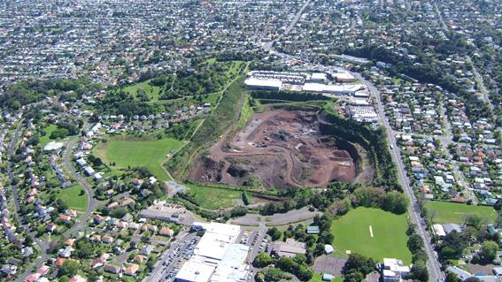
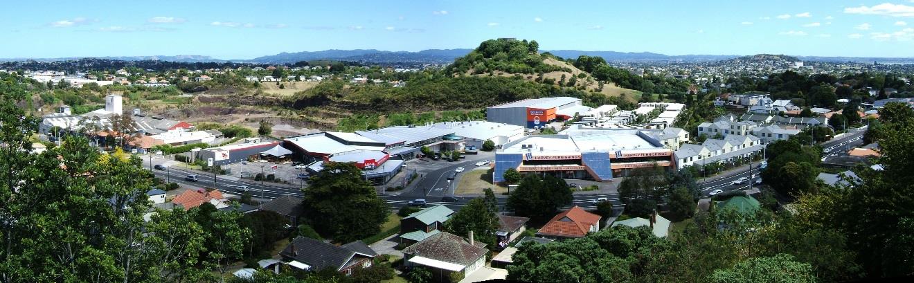
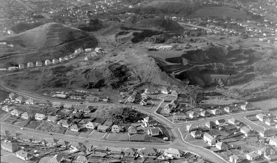
Aerial photograph looking north over Three Kings Volcano and Three Kings, 2009.
3
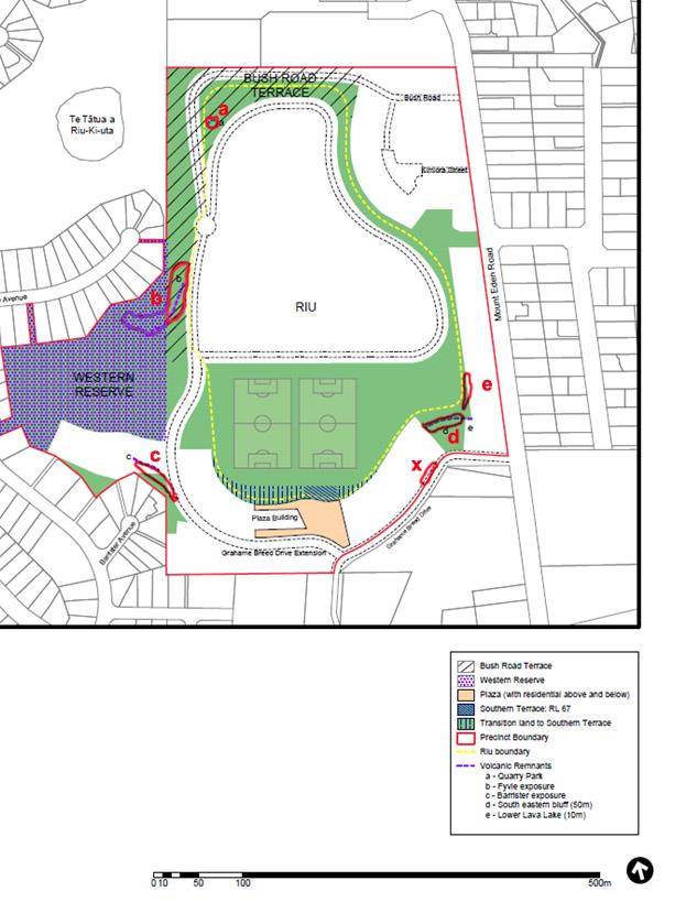 Precinct Plan 1A with modified mapped extent (in red) of remnant volcanic features a-e, plus x
4
 Google Earth vertical photo with extent of remnant volcanic features plotted on it.
5
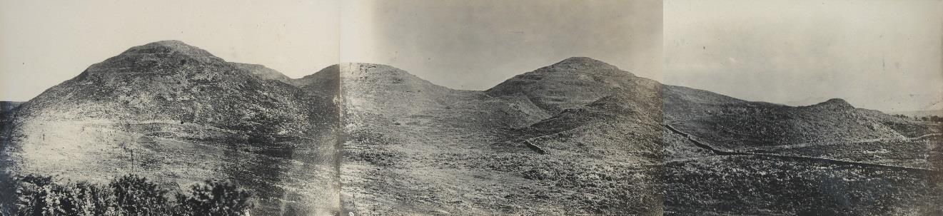
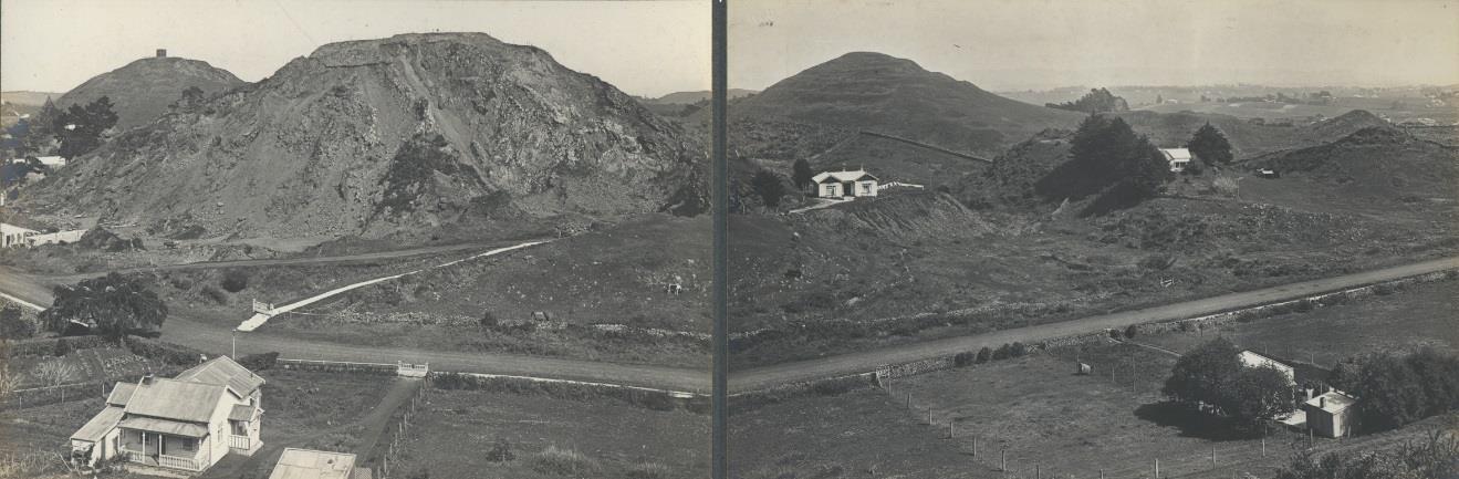
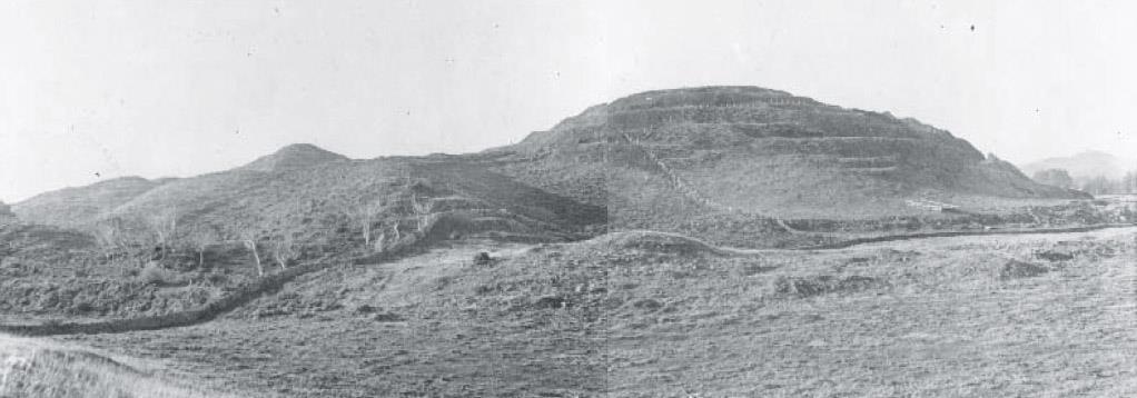
 View of Three Kings scoria cones from northeast rim of tuff ring in 1868, prior to quarrying. Photo
Richardson Album.
View of Three Kings scoria cones from northeast rim of tuff ring in 1920, when quarrying had started.
Photo Richardson Album.
View of Three Kings scoria cones from northeast rim of tuff ring in 2010, when quarrying had
essentially finished. Photo Bruce Hayward.
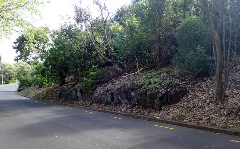
Volcanic remnants
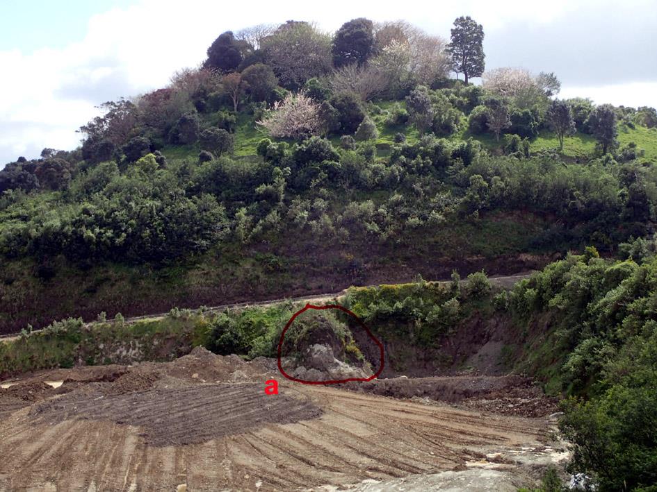
a. Quarry Park
This feature consists of a hard knob of solid basalt about 10 m in diameter and 6-8 m
high. The basalt is cut by irregularly-oriented joints that provide no hint at the origin of the
rock. It was not mentioned by either Dr Lindsay or Mr Hind in their Environment Court
evidence. In scoria quarries, such as Three Kings, patches of extra hard rock are sometimes
left and quarried around. Thus it would seem that this knob is probably some of the plumbing
within one of the scoria cone/mounds. It should be noted that there were other areas of hard
basalt in the central part of the pit and in the southwest corner that are now buried by fill.
6
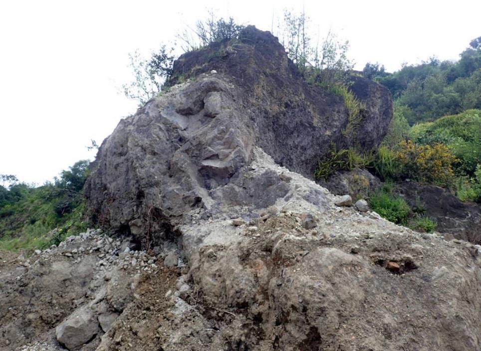
Examination of old photographs and maps suggest that Quarry Park remnant may be
a plug of solidified magma that cooled inside the vent of one of the smaller scoria
cones/mounds. As such this is the only physical remnant and reminder of one of these smaller
scoria cones that has been quarried away. I therefore assess that this feature has local
significance and has potential for interpretation within Quarry Park in this northwest corner
of the old quarry as an example of the plumbing that would have existed beneath each scoria
cone. The solid basalt knob shows no sign of instability or danger of face collapse or loose
rocks. Therefore it should require minimal management other than perhaps control of
vegetation that may grow up around and on it.
Location of remnant volcanic feature a, in northwest corner of former quarry, 2017.
Remnant volcanic feature a, from the northwest, 2017.
7
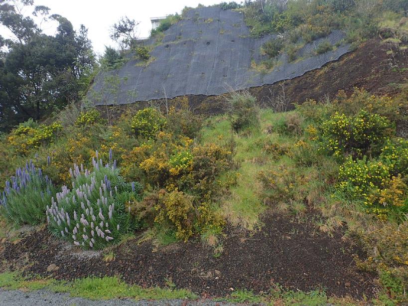
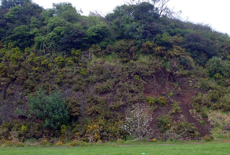
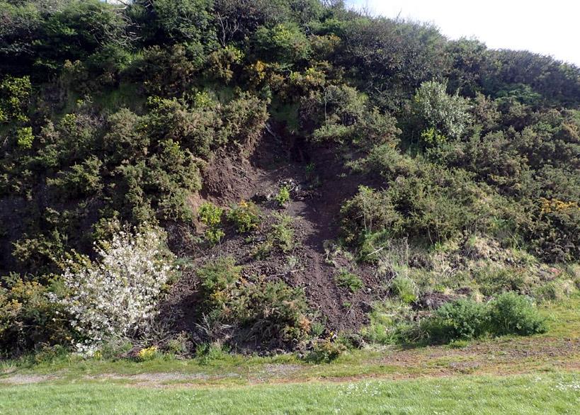
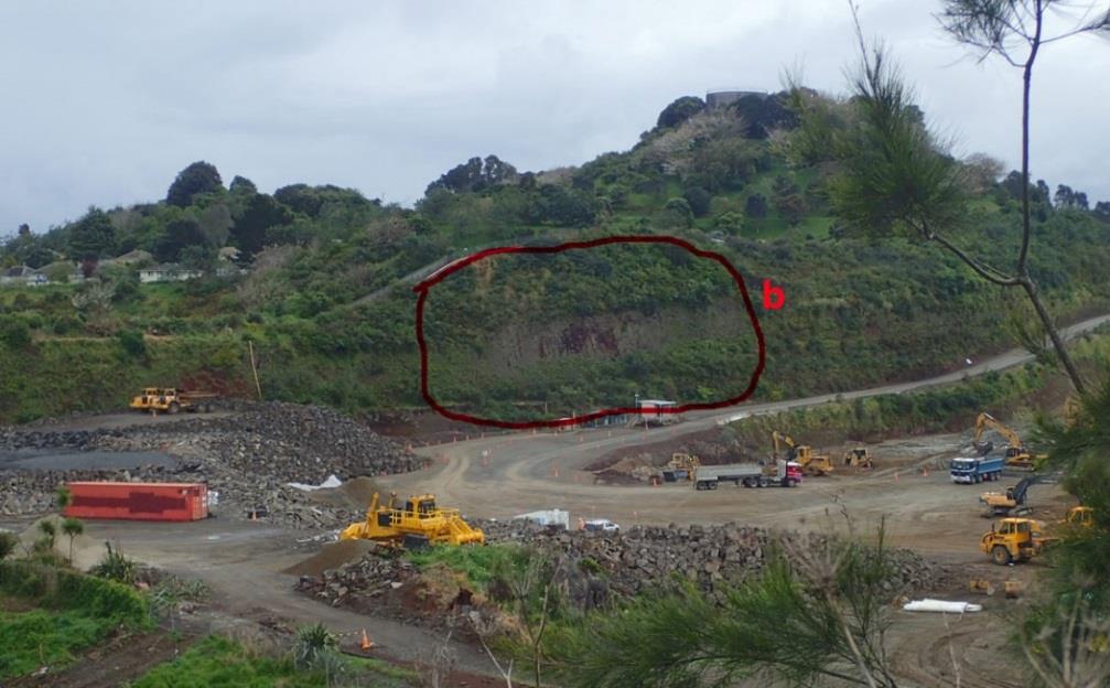 b. Fyvie exposure
On the supplied Precinct Plan 1A, this feature is shown as a dashed line that runs along
a section of the cliff face at the lower end of the access road into the old quarry and then
sweeping around to the west to encompass the former quarry slope on the north side of Three
Kings Reserve Football Field 2 (western reserve) at the back of 35-47 Fyvie Ave. This feature
can be considered in two halves. The steep slope in the reserve is covered in regenerating
vegetation and appears relatively stable. It has no exposures of rock and in my opinion has no
particular geoheritage value as a stabilised, vegetated former quarry wall. I recommend that it
not be included in the area identified as Fyvie exposure.
The remainder of the Fyvie exposure is a more recent former quarry cutting and varies
in slope from vertical to about 70 degrees with a narrow zone of scoria scree along the base.
Much of this scoria face has some low vegetation on it but the massive nature of the scoria
can still be seen in the face. I can see no layering in it, nor can I see any plumbing (dike
intrusions) cutting through it.
Scoria exposures can be found in many of the old quarries around Auckland and also
in road and track cuttings (e.g. within Big King Reserve, in Eden Gardens, Tahaki Reserve,
road to top of Maungakiekie, two former quarries on Maungakiekie, remnant features c and d
here). The main geological value of Fyvie exposure is to show that the original crater was at
least as deep as the base of the exposure and the scoria cones that were visible before quarrying
began were only the tops of much taller cones that had built up on the original floor of the
large explosion crater. As no layering can be seen in this exposure it is not completely clear
which vent or vents it was erupted from and therefore which scoria cone/s it is the base of. Dr
Lindsay suggests in her evidence that it is part of the base of the South Cone. I consider the
exposure has minimal geoheritage value and this is insufficient to justify protection of the
bluff. Assuming this man-made bluff is retained, I suggest that future management might
initially be to leave it as it is and let vegetation grow on the basal scree and face. Other
measures such as bolted matting over part of the face need only be considered if instability
develops on the face over time. There is unlikely to be a major collapse event, it is more likely
to be progressive slow frittering with loose scoria falling and rolling down the face and
collecting in the scree at the bottom.
Location of remnant volcanic feature b, Fyvie exposure, 2017.
8
 Close-up wide-angle photograph of remnant volcanic feature b, Fyvie exposure, 2017, taken from the
verandah of the small office building in previous photo.
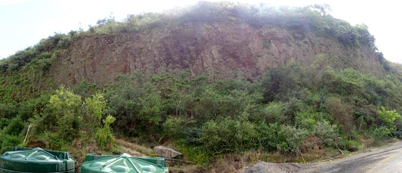
c. Barrister exposure
This exposure is exactly where it is shown on the supplied Precinct Plan 1A. It is the
former quarry face on the southeast corner of Three Kings Reserve Football Field 2 below the
back boundaries of 4-10 Barrister Ave. It consists of massive loose scoria with no clear
layering. It is intruded by a 20 cm-thick sheet-like dike (plumbing) of basalt at its western end.
Unfortunately this dike occurs in the most unstable part of the face and most of the exposed
dike has been undercut by frittering scoria and has broken into pieces and is sliding down the
scree below. The upper 60-70% of the face is partly vegetated scoria face with the lower
portion a 3-5 m wide belt of scoria scree that is developing soil and becoming vegetated.
Clearly the steep upper half of the face at the eastern end of the exposure was frittering away
quickly and threatening the stability of the private land above, as matting has been bolted
across the face to stabilise it.
The main/only geoheritage value of this exposure is that it and the slight rise it
underlies is the visible remnant of the large South Cone (as noted in the evidence of Dr
Lindsay) that has been otherwise completely quarried away. Like b, exposures of massive
scoria are not rare or unusual around Auckland or around the old quarry and there are no
structures within the exposure (except for the collapsing dike that cannot be saved). Thus I
consider this volcanic remnant to have minimal value as an exposure and some local value as
a reminder of the South Cone. I do not believe these geoheritage values are sufficiently high
to justify protection of the man-made bluff as a geological exposure of the rock. Assuming
this man-made bluff is kept, I envisage the long term management may need to be a
combination of face stabilisation measures (?matting) and vegetation growth for stabilisation.
The main drawback with vegetation growth is that most of the vegetation is likely to be weedy,
such as the gorse that is already taking hold in some parts, and this may be undesirable and a
fire hazard in dry summers.
9
 Location of remnant volcanic feature c, Barrister exposure, 2017.
Remnant volcanic feature c, Bannister exposure east end, showing matting over upper part and grass,
lupin and gorse on scree at bottom, 2017.
10
 Western half of remnant feature c, Bannister exposure, 2017.
Remnant volcanic feature c. Bannister exposure, showing western area of rapidly eroding scoria
where a thin dike has broken apart and is now sliding down the scree, 2017.
11
 View from the south over partly quarried South Cone, 1949. Note the slopes rising up beyond the end
of Bannister Ave (centre) – remnant feature c.
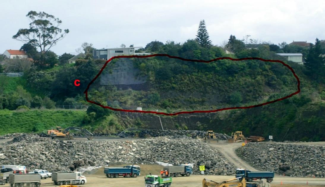
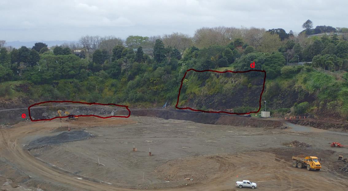
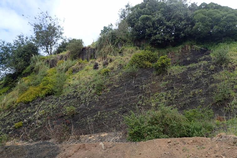
d. South eastern bluff (50 m)
This remnant feature appears to be correctly mapped on the Precinct Plan 1A. It
extends for about 50 m across the upper 50 m of the old quarry face in the southeast corner. I
am unsure why this feature has been called a bluff whereas it is of the same nature as b and c
above, which have been called exposures. The geoheritage value of this bluff is the exposure
of the lower southeast scoria slopes of South Cone with the solidified northern edge of the
lava lake lapping up to and over it, up to the original maximum elevation of the lava lake
surface (80 m ASL) at the very top of the cliff.
This is the only place where the relationship of the lava lake with the scoria cones can
be seen and clearly the lava flowed out after this main cone had been fully built. Indeed it is
the only place in the Auckland Field where this relationship can be seen in cross-section. Lava
lakes are known in four of Auckland’s volcanoes. In three they filled the moat between central
scoria cones and the explosion crater wall (Three Kings Volcano, The Domain Volcano and
Crater Hill). A crater lake without a central scoria cone is present in the hidden Grafton
Volcano.
Thus I agree that this feature has sufficient geoheritage value to warrant the exposure
being retained, especially the upper half, with limited (if any) artificial stabilisation works
across it. The solid basalt at the top of the face imparts a certain degree of stability to the face
as this will not fritter back like the loose scoria beneath. The scoria beneath the solid face will
slowly fritter back and roll down to the scree at the foot. This may eventually undercut the
base of the solid lava lake basalt and threaten potential collapse of one or more large blocks
of basalt breaking along their cooling joints and rolling down to the bottom of the slope.
When/if this stage is reached there could be a safety hazard that may need to be managed by
erection of a safety fence a distance back from the foot of the exposure. I note that a drainage
trench is being constructed along the base of this exposure and bench, which should provide
considerable separation between people and the base of the exposure. This situation may not
arise for many years and is not an immediate concern.
12
In the meantime, to retain the visual values of this exposure there may need to be
periodic spraying of the upper 20 m of this exposure to prevent too much vegetation growth
(e.g. gorse) hiding the rocks. Dr Lindsay, in her evidence, says “Where possible, preserve the
view of some of the upper walls of the quarry that display the geology and history of the
eruptions, particularly the southeastern face that clearly displays part of the solidified lava
lake of basalt abutting against and over the lower slopes of one of the quarried away scoria
cones”.
Location of remnant volcanic features d, southeastern bluff, and e, lower lava lake, in cliffs in the
southeast corner of the old quarry.
13
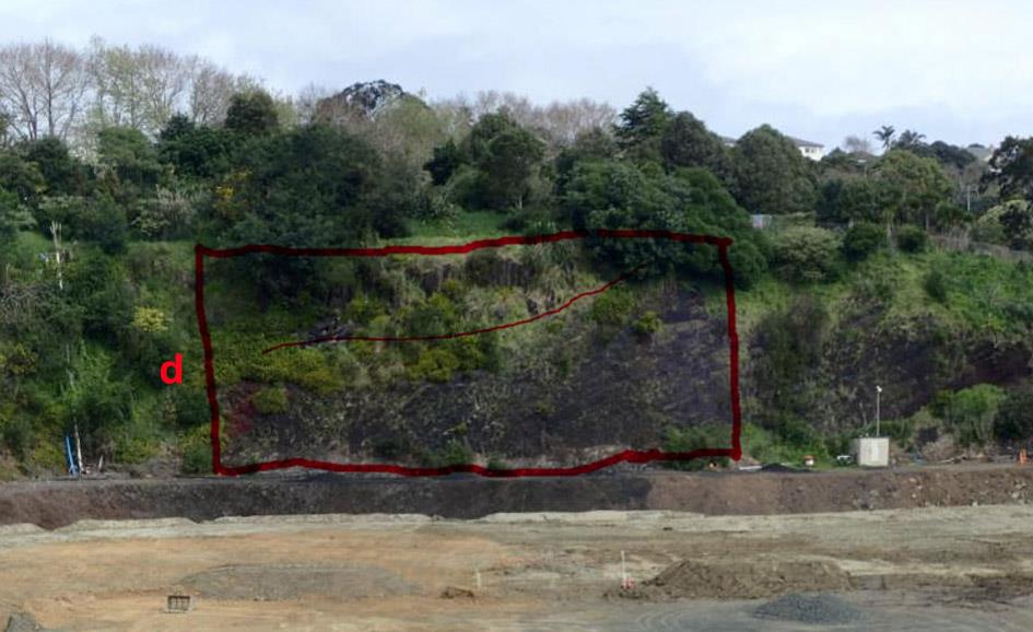
 Extent of remnant volcanic feature d with thin red line showing where solidified lava lake laps
onto the scoria cone, 2017. Retaining the western (right) end of this exposure, where the
scoria cone rises to the top of the exposure, is critical to understanding its significance.
Remnant volcanic feature d showing layering in scoria that documents the growing shape of the scoria
cone beneath its contact with the lava lake, 2017.
14
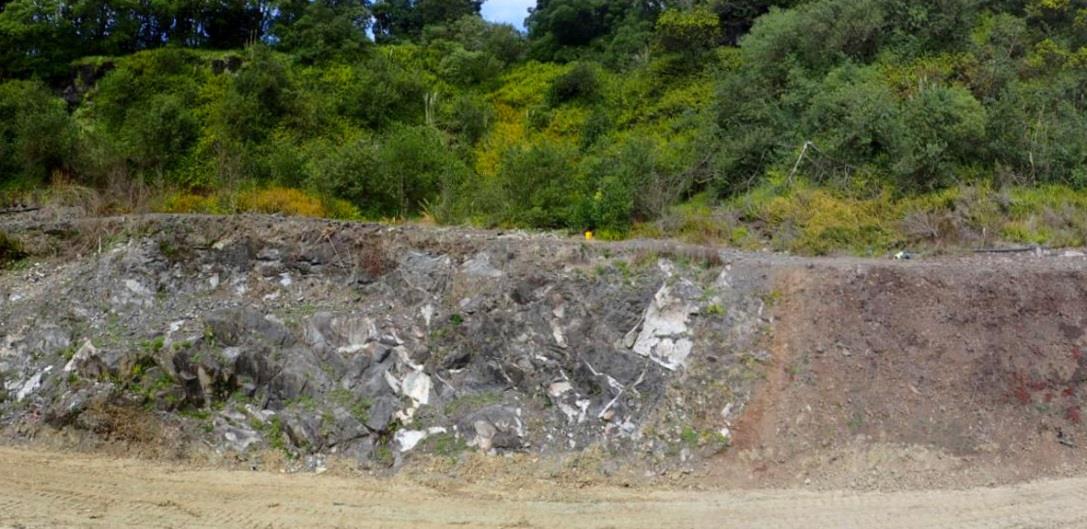 e. Lower lava lake (10 m)
This feature was not mentioned in the evidence of Dr Lindsay but was noted in the
evidence of Mr Hind, who had the advantage of being allowed access into the quarry. It
consists of solid basalt lava with irregular joints exposed in the lower part of the old quarry
cliffs in the south eastern corner of the quarry. Precinct Plan 1A shows it as occurring directly
beneath d (above) but my visit shows that it is incorrectly located and occurs mostly at the
base of the west-facing part of the eastern quarry face and not in the north-facing part. The
main part of the exposure is in the recently excavated wall of the drainage trench.
Exposures in the surrounding cliff above and to the side of this solid basalt are limited
and obscured by scree and vegetation. In places this solid basalt overlies scoria, underlies
scoria and has a vertical, slightly baked contact with scoria. From these exposures I cannot be
certain of whether this basalt was an earlier lava lake than the more obvious one above or
whether this basalt was magma that was intruded into the scoria cone as part of its shallow
plumbing. It appears unlikely that even with complete vegetation clearance that an easily seen
and interpretable understanding of how this basalt was emplaced will be possible.
Thus the main geoheritage value of this basalt is as a source of fresh basalt rock that
might be sampled for scientific study to help understand the eruption sequence and magma
sources of Three Kings volcano. The solid basalt walls of the drainage trench are likely to
remain unweathered and unvegetated for many decades or more and therefore available for
scientific sampling without special management. They are stable and will not require any
stabilisation work that might hide the rock. I therefore conclude that this feature has limited
geoheritage value and does not warrant any special protection nor management.
Remnant volcanic feature e, lower lava lake, is the solid grey basalt in the face below the bench in the
wall of the drainage trench.
x. Grahame Breed Drive lava lake remnant
This small exposure of columnar-jointed basalt is discussed extensively in the
Environment Court evidence of Dr Lindsay and Mr Hind. Both agree with the original
interpretation (Hayward and Kenny, 2009) that it is a solidified remnant of the top of the lava
lake close to where it abutted the slopes of the South Cone. Mr Hind disputes Dr Lindsay’s
contention that it has any significance because he says it is a man-made feature and not a
unique remnant of the lava lake. All the remnant features a-e are however man-made in that
the rock is exposed in man-made cuttings, but in all instances the rock is in-situ and natural. I
15
agree with Mr Hind that there are other remnants of the lava lake scattered around the inner
wall of the explosion crater, but this is the only surface exposure in the middle of the crater
adjacent to the base of the scoria cones that gives physical proof of the extent of the lake and
its consistent “high-water mark”.
The top of the exposure is at about 80-82 m ASL which is the maximum elevation of
the crater lake surface and the same elevation as other remnant parts around the inside of the
explosion crater wall. This and the exposure in feature d (above) are the only remnants of the
solidified lava lake adjacent to the scoria cones. As such I assess this basalt exposure on the
side of Grahame Breed Drive as being of greater local significance than features b, c or e
(above) and on a par with features a and d. The rock is solid and in-situ and if left alone with
no management would last indefinitely and be visible.
I understand that maybe this section of Grahame Breed Drive may need to be widened
to provide better access into the quarry precinct. If this is so, then it would still be highly
desirable to retain an exposure of the basalt in any new cuttings that are made, to provide
physical evidence of the location and elevation that the lava lake reached. A minimum
exposure width of 5 m and height up to the high-water mark of the lake would suffice and
would be suited to interpretation.
1899 picture of the southern side of Three Kings cones showing the remnant lava lake terrace at the
foot of the cone.
16
 Remnant feature x, Grahame Breed Drive lava lake exposure, that should be retained (further back
into the knoll) even if the road is widened.
Evidence by Dr Lindsay and Mr Hind
I have read the evidence presented at the Environment Court by volcanic geologist Dr
Jan Lindsay and the rebuttal evidence of engineering geologist Mr Kevin Hind. There is no
significant difference in opinion between them and I understand this was apparent in the court
hearings. The apparent difference is largely semantic and Mr Hind’s contention that a bluff
cannot be man-made.
Dr Lindsay identified four “key important geological features that still remain”. These
were:
1. Big King (not within the precinct plan);
2. Barrister Ave bluff (remnant of quarried away southern scoria cone). Remnant feature c.
3. Fyvie St bluff (remnant of quarried away southern scoria cone). Remnant feature b.
4. Bluff on Grahame Breed Drive (remnants of lava lake). Remnant features d and x.
Dr Lindsay concludes that “to maximise the scientific and geological value of the
Three Kings volcano, future development should:
a. Not remove further volcanic deposits;
b. Enable access, where possible, to the few remaining outcrops, to enable scientific and
public access, possible future signage and / or research;
c. Not obscure the current visibility of Big King scoria cone as the only remaining visual
reminder that this was the site of Auckland’s largest tuff ring with one of the most
complex mixes of scoria cones, lava lakes and flows within it;
d. Where possible, preserve the view of some of the upper walls of the quarry that display
the geology and history of the eruptions, particularly the southeastern face that clearly
displays part of the solidified lava lake of basalt abutting against and over the lower
slopes of one of the quarried away scoria cones;
e. Protect existing features, and enhance access to these features for scientific and
experiential reasons.”
17
It appears to me that in the present precinct plan, points a and c are largely met.
Points b, c and e are largely accepted by the precinct plan and identified features b, c, d
and e. I note however, that in the near two years since Dr Lindsay prepared her evidence,
there has been considerable vegetation growth across many of the quarry wall faces –
especially those made of loose scoria and that this will continue. While her request that
long-term visibility of the rocks in the exposures is a desirable goal, it is unfortunately
impractical in the long term, unless the authority managing this land is prepared to adopt
a management regime of semi-annual vegetation spraying/clearance and acceptance of
continual slow erosion back of the scoria faces with build-up of scree along the bottom. I
think this management regime is impractical and therefore I deem features b, c and e as
not having sufficient geoheritage value to warrant this kind of management regime to
maintain them long-term as “exposures” of the rock.
Mr Hind disputes Dr Lindsay’s claim that the Grahame Breed Drive “bluff” is an
important geological feature, as he claims it is a man-made road cutting, and that
exposures of lava lake basalt exist in at least four other places as well as in the quarry
itself. I agree with Mr Hind that the basalt exposure has probably been modified by road
widening and that there are other exposures of the lava lake basalt elsewhere.
I disagree with Mr Hind’s contention that this exposure is not important – I
concur with Dr Lindsay that it, along with complimentary feature d, are the most
important remnant volcanic features in the precinct. This feature x is the only surface
exposure of the solidified lava lake basalt at its high-tide level nearer the centre of the
crater where it lapped up onto the scoria cone slopes. All the other surface exposures are
around the inner slopes of the explosion crater wall.
Mr Hind contends that the associated knoll next to Grahame Breed Drive is not a
natural feature and was modified by quarrying and shows a series of historic photos to
support his interpretation. I disagree with some of Mr Hind’s interpretation of the historic
photos as shown in the 1899 pre-quarrying photo (which he did not show). This
disagreement is not significant as it is the basalt at this elevation that is most important,
and whether the knoll is natural or modified is insignificant. Mr Hind does not dispute
that the basalt here is indeed part of the lava lake at its high-tide level up against the base
of the scoria cone.
Mr Hind disputes that the former quarry faces called Fyvie Bluff and Bannister
Bluff by Dr Lindsay are bluffs at all and notes correctly that they are man-made. Dr
Lindsay clearly did not imply they were natural. The term bluff does not necessarily
imply the feature is natural, but the term exposure is probably preferable. I agree with Mr
Hind (and I am sure Dr Lindsay does too) when he states:
“The bedded scoria deposits exposed within the non-vegetated parts of the Barrister Ave
and Fyvie St cuttings are characteristic of the majority of deposits within the Three Kings
volcano. These exposures are not unique in that similar deposits are present throughout
the quarry, including the haul road and southern wall.” These are however the largest
faces remaining and hence Dr Lindsay’s selection of them as being important.
Mr Hind additionally notes that:
“Basalt can be seen within the lower face of the southern wall of the quarry (Remnant
feature e), separated from the lava lake basalt by scoria. Although the scoria is overlying
the lower basalt in a strict stratigraphic sense, it is likely that the lower basalt represents
18
lava that forced its way through the side or base of the pre-existing scoria to flow east or
south. This is typical of the Auckland volcanoes. The lower basalt may represent the initial
flows that formed the lava lake that were subsequently added to by the upper basalt or they
may represent an earlier event. Regardless of their relationship, the basalts are visually
distinct, with the upper basalt being columnar jointed and darker that the more blocky and
lighter grey lower basalt.”
This feature was not seen nor commented upon by Dr Lindsay in her evidence. In
my description of feature e (above) I do not disagree with Mr Hind’s attempts to interpret
this lower lava. He presumably saw this feature when there was more exposure. I do not
rate this feature highly in terms of its geoheritage value because its exact nature is not clear
and it will be difficult to present a convincing explanation of it for the public. Because it is
solid basalt in part of the wall of the drainage channel I expect fresh basalt will be available
for scientific sampling and study for many decades without any special management of the
face.
In summary, I do not consider there is much significant disagreement between the
two geologists’ evidence. Similarly I think in general their evidence and my assessments
coincide quite well, except that Mr Hind did not give the same level of significance to
remnant volcanic feature x. My compromise is to allow widening of Grahame Breed Drive
but still retain a surface exposure of the lava lake in the new road cutting, a few metres
north of the existing exposure.
Comments on new volcanic provisions in emended Precinct Plan
I am happy with all proposed additions/changes except where noted below:
Outcomes
“(8)
Key remnant features of the original volcanic landform shown on Three Kings:
Precinct Plan 1 are retained and in some cases enhanced (features a, d and e on
Precinct Plan 1).”
While I have no objection to retaining all remnant features a-e, I do not consider
that the geoheritage values of b, c and e are sufficient to be used to justify their
protection. I do believe however that remnant feature x has sufficiently high geoheritage
value to justify protection (perhaps in a modified location to allow road widening) and
should replace feature e. I agree that feature a should be enhanced by removal of fill
around it and minor periodic vegetation clearance and that feature d could be enhanced
by periodic vegetation spraying on selected parts. If e is retained I think it could be
removed from within the brackets as I cannot see how it could be enhanced to improve
visibility and understanding.
19
“I333.6.13. Remnant volcanic features
(a) Barrister Exposure, Fyvie Exposure and Quarry Park.
No earthworks shall occur on the remnant volcanic features shown in Precinct Plan 1
being features identified as Barrister Exposure, Fyvie Exposure and Quarry Park
except that this rule shall not preclude works:
(i) necessary only for the purpose of making safe any aspect of the exposed rock
faces;
(ii) including excavation of piles necessary to form an elevated boardwalk and
associated facilities connecting Grahame Breed Drive Extension and the Whare
Manaaki, to the pathway adjacent to Fyvie Avenue and accessing Te Tātua a
Riukiuta;
(iii) in the north-western corner of the site to implement the storm water management
wetland and associated boardwalk provided these works do not impact the
identified exposed remnant volcanic feature labelled (a) exposed by rock aspects
in these areas; and
(iv) associated with the removal of any weeds or other earth or vegetation to better
display the rock formation.
(v) Necessary to undertake rehabilitation due to contamination (if required).
(b) South-Eastern Bluff
No building shall be located on that part of the remnant volcanic features labelled (d)
on Precinct Plan 1. Works under the rehabilitation control shall be confined to those
necessary for:
(i) stability purposes;
(ii) to provide the final contour for the southern terrace and access to the southern
terrace;
(iii) public pathways to the face to enable people to appreciate the geological form of
this area;
(iv) works associated with the removal of any weeds or other earth or vegetation to
better display the rock formation.
The minimum length of the northern face of the feature shall be 50m.
(c) Lower Lava Lake
In addition to Rule I333.6.13(b) above, no building shall be erected below RL74
(excluding in-ground piling and foundations) on the remnant volcanic feature labelled
(e) on Precinct Plan 1. The effect of this is to extend the visible length of the volcanic
feature when viewed from the Riu. Works under the rehabilitation control below RL74
shall be confined to those necessary for:
(i) stability purposes;
(ii) to provide the final ground levels for the southern terrace and access to the
southern terrace;
(iii) public pathways to the face to enable people to appreciate the geological form of
this area;
20
(iv) works associated with the removal of any weeds or other earth or vegetation to
better display the rock formation.
The minimum length of the northern face of the feature below RL 74 shall be 60m.
This is inclusive of the 50m minimum length specified in I333.6.13(b) above.”
My comments on (a-c) above are:
(a) Could just apply to Quarry Park
(b) The form of the south eastern face is best seen from a distance. Providing a public
pathway to provide access to the feature is unnecessary and unwise for safety
reasons. This clause should be deleted. The extent of the remnant feature d protected
should be that outlined in red on my 2017 photograph.
(v) Most of the value of this exposure is in the uppermost part of the exposure and
thus this is the part requiring the greatest protection. I am concerned about (ii) that
would allow earthworks “to provide the final contour for the southern terrace and
access to the southern terrace”, if these involved lowering the ground level at the
top of the exposure. I suggest (ii) be deleted as I can only envisage that this would
involve lowering the ground level.
(c) I suggest replacing remnant feature e with remnant feature x with emended
conditions for it, which will depend on where x is located – in its present position or
further to the north in a new cutting at the same elevation.
References
Hayward, B.W., Kenny, J., 2009. Three Kings lava lake, Auckland. Geocene 4, 9-11.
Hayward, B.W., Murdoch, G., Maitland, G., 2011. Volcanoes of Auckland: The Essential
Guide. Auckland University Press, 234 p.
21