
ŌTAKI TO LEVIN ROAD OF NATIONAL SIGNIFICANCE
IMPLICATIONS OF ROUTE OPTIONS NC4 & NC5
ON LEVIN EASTERN GROWTH AREA
LANDSCAPE + URBAN DESIGN
ACT
INFORMATION
RELEASED UNDER THE OFFICIAL
2
Client:
MWH on behalf of NZTA
Project:
Ōtaki to Levin ‘Roads of National Significance’
Code:
2923
Report:
Implications of Route Options NC4 & NC5
on Levin Eastern Growth Area
Status:
Final
Date:
8 May 2017
Author:
Gavin Lister
ACT
Isthmus
PO Box 90 366
Auckland 1142
+64 9 309 7281
+64 27 435 7844
[email address]
INFORMATION
RELEASED UNDER THE OFFICIAL
No.
Date
Details
Author
QA
1
14/03/2017
Draft 1
Gavin Lister
GL
2
21/03/2017
Draft 2
Gavin Lister
GL
3
18/04/2017
Draft 3
Gavin Lister
GL
4
08/05/2017
Final
Gavin Lister
GL
170508_2923_GL_Implications of Route Options NC4 and NC5 on Levin Eastern Growth Area
link to page 4 link to page 6 link to page 6 link to page 6 link to page 7 link to page 7 link to page 7 link to page 8 link to page 9 link to page 9 link to page 9
3
1
INTRODUCTION ................................................................................................. 4
2
IMPLICATIONS OF ROUTE OPTIONS FOR THE EXISTING STRUCTURE PLAN ........... 6
NC4 ....................................................................................................................6
NC5 ....................................................................................................................6
MCA Scoring .......................................................................................................7
3
IMPLICATIONS OF ROUTE OPTIONS FOR PROJECTED URBAN DEVELOPMENT ....... 7
ACT
NC4 ....................................................................................................................7
NC5 ....................................................................................................................8
4
CONCLUSIONS ................................................................................................... 9
Existing Structure Plan ........................................................................................9
Projected Urban Development ............................................................................9
INFORMATION
RELEASED UNDER THE OFFICIAL
170508_2923_GL_Implications of Route Options NC4 and NC5 on Levin Eastern Growth Area
ACT
INFORMATION
RELEASED UNDER THE OFFICIAL
ACT
INFORMATION
RELEASED UNDER THE OFFICIAL
6
1.6
The RoNS standards require high-speed, dual-carriageway expressways with limited-
access. These standards lead to the following characteristics that are relevant when
considering future development:
The expressways have limited crossing points – and therefore potential impacts on
connectivity;
The expressway will potentially form a barrier between different landuses – which
can be an advantage if one is seeking a defensible boundary between, for instance,
urban and rural areas, but can also be a disadvantage if seeking to integrate areas
with the same landuse; and
ACT
Areas immediately adjacent to the expressway will be exposed to adverse noise and
visual amenity effects.
1.7
The following memo is a commentary on the implications of the NC4 and NC5 route
options for each of the development scenarios discussed above in light of these
characteristics.
2
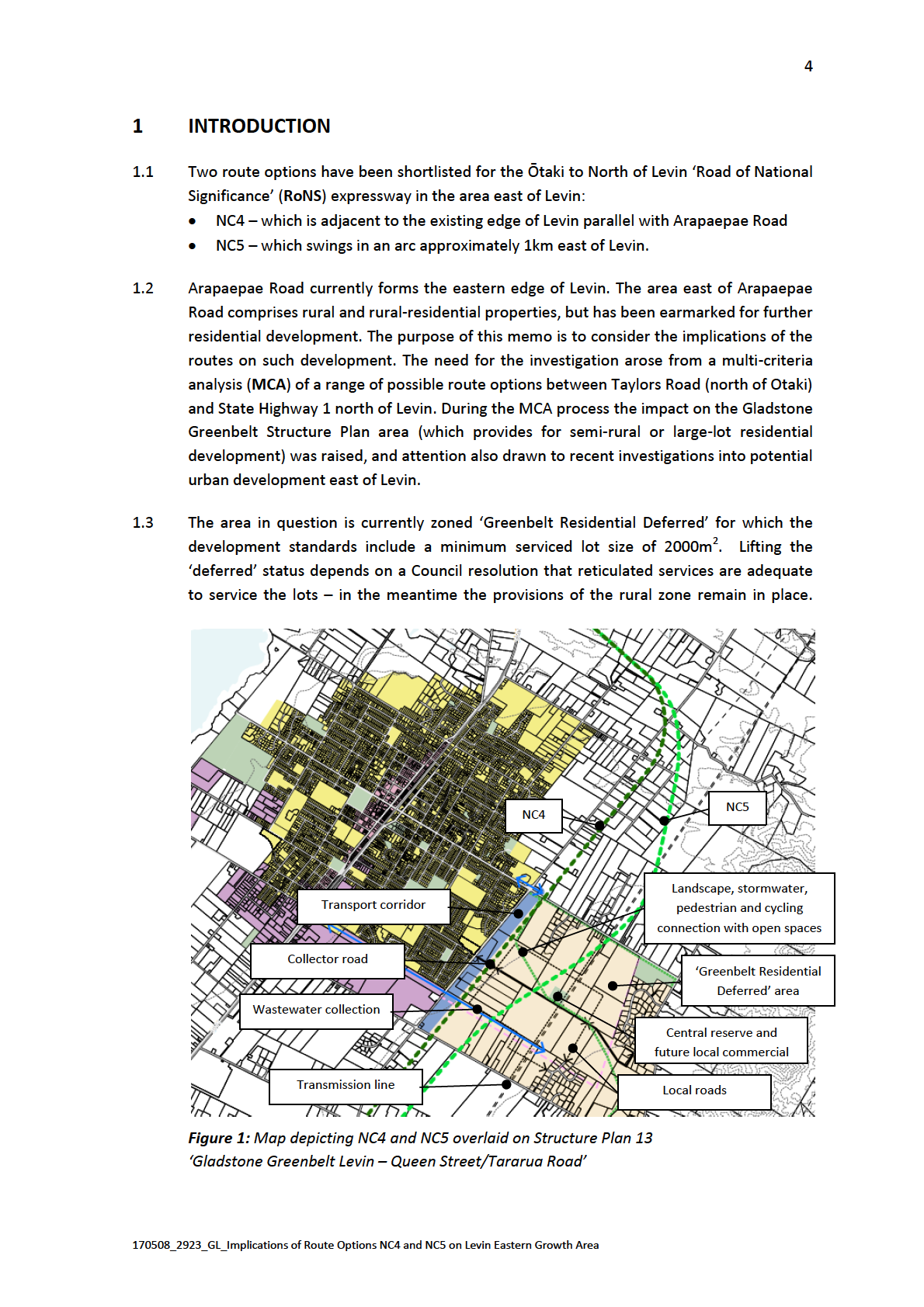
IMPLICATIONS OF ROUTE OPTIONS FOR THE EXISTING STRUCTURE
INFORMATION
PLAN
NC4
2.1
NC4 would be in keeping with the existing structure plan:
The expressway alignment follows the transportation corridor identified on the
structure plan, except that it is transposed approximately 100m to the east to avoid
the stand of bush adjacent to Arapaepae Road and some 300m south of Queen
Street;
The alignment is square to the cadastral and road pattern (both the existing and
proposed pattern), making for efficient subdivision;
The expressway would form a clear and defensible boundary between Levin’s urban
area and the type of semi-rural development envisaged by the structure plan;
There would be no impacts on features of the structure plan, such as the local road
network, the green network (‘landscape, stormwater, pedestrian and cycling
connection with open spaces’), central reserve, and ‘future local commercial’; and
The 100m wide strip of land that would be left between Arapaepae Road and the
expressway could be realistically developed for 2000m2 lots accessed from a re-
purposed Arapaepae Road.
NC5
RELEASED UNDER THE OFFICIAL
2.2
NC5 would disrupt the pattern of development provided for by the structure plan for the
following reasons:
The expressway would bi-sect the structure plan area. It would divide what would
otherwise be a coherent area, compromise some features of the structure plan (i.e.
170508_2923_GL_Implications of Route Options NC4 and NC5 on Levin Eastern Growth Area
7
the location of the central reserve and ‘future local commercial’), and require
reconfiguration of the proposed local road network and green network;
The alignment is diagonal to the cadastral pattern, making for less efficient
subdivision;
The alignment would result in some land sandwiched between the expressway and
transmission line corridor where they converge. It is likely, though, that the
expressway and transmission line design would be integrated so that they are parallel
with other where they come together, which would reduce the degree of impact on
land development.
ACT
MCA Scoring
2.3
NC4 (as part of ‘Route 2’) received a more favourable ranking (for landscape and visual
matters) in the MCA process for reasons that included:
Its alignment adjacent to the eastern edge of Levin, reinforcing the existing boundary
between urban Levin and the more rural or rural-residential character area; and
Its square alignment with the cadastral and street pattern.1
INFORMATION
2.4
NC5, on the other hand, received a less favourable ranking (as part of ‘Route 1’) for
reasons that included:
Its bisecting of a rural and rural-residential area; and
Its diagonal alignment to the cadastral and street pattern.2
3
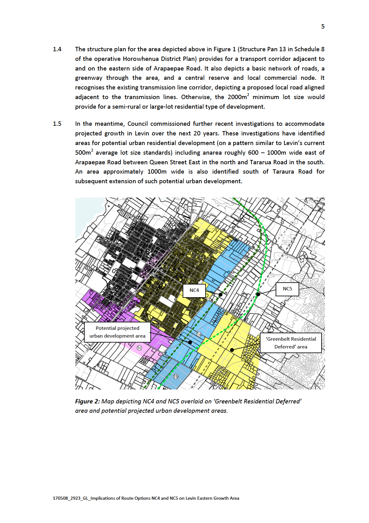
IMPLICATIONS OF ROUTE OPTIONS FOR PROJECTED URBAN
DEVELOPMENT
NC4
3.1
On the other hand, NC4 would be less preferable for the projected urban development
being investigated east of Arapaepae Road for the following reasons:
A new urban residential area in this location would be separated from Levin’s existing
urban area by the expressway: the urban development would be forced to leap-frog
the expresseway. Such effects would be compounded by the width of the existing
Arapaepae Road corridor and the 100m offset between Arapaepae Road and the
expressway;
The two points of access across the expressway at Queen Street and Tararua Road
would be less suitable for urban development than for a lower density semi-rural
type of development envisaged by the existing structure plan. The expressway would
RELEASED UNDER THE OFFICIAL
also hinder a possible new connection from Arapaepae Road to Liverpool Street;
1 Ōtaki to Levin Road of National Significance, MCA Combined Routes and Interchanges, Urban Design + Landscape + Visual, Isthmus,
16 November 2016, paragraph 4.18
2 Ibid, paragraph 4.2
170508_2923_GL_Implications of Route Options NC4 and NC5 on Levin Eastern Growth Area
8
The 100m offset of NC4 from Arapaepae Road is an inefficient dimension for urban
development because it is too deep for single urban lots and too shallow for three
rows of lots and a street. (It is noted though, that the actual alignment of the future
highway could be fine-tuned to fit development patterns given that the route is
nominally 150m wide at this point and the highway footprint may occupy in the order
of 60m or thereabouts). The relatively narrow width would also restrict choices as to
the future character of Arapaepae Road after it is divested as a State Highway (for
instance, opportunities to develop it as a wide boulevard entrance to Levin); and
The expressway would be exposed to urban residential lots on both sides – which ACT
may require such measures as set-backs (i.e. it would reduce efficient use of land
made available for urbanisation) or noise walls (with potential visual amenity effects).
NC5
3.2
NC5 could result in a more favourable outcome for projected urban development east of
Levin – potentially forming a logical boundary between urban development on one side
of the expressway and semi-rural type of development on the other side. However, such
an outcome would require the urban development area being adjusted to fit the
INFORMATION
expressway:
At Tararua Road route NC5 is approximately 450m from Arapaepae Road and the
projected area for urban development is approximately 1km wide; and
At Queen Street East NC5 is approximately 1km from Arapaepae Road and the area
projected for urban development is approximately 600m wide.
3.3
Such an adjustment would bias the urban development area towards Queen Street,
which is Levin’s central east-west axis.
3.4
Subject to such an adjustment, NC5 would have the following benefits:
It would enable the new urban development area to be contiguous and integrated
with Levin’s existing urban area. Arapaepae Road could be effectively re-purposed as
an urban collector road, connecting directly with a hierarchy of streets within the new
urban area, and providing for effective distribution between the new urban area and
Levin’s street network. Creating a connection to Liverpool Street would also be more
straightforward exercise than NC4;
The new highway would form a defensible boundary between Levin’s urban area on
the one hand, and large-lot semi-rural development on the other;3 and
Only one side of the highway would abut urban residential lots, reducing potential
requirements for measures such as noise walls or off-set buffers. Larger lots to the
east would provide more opportunities to address noise by way of setbacks.
RELEASED UNDER THE OFFICIAL
3.5
It is worth noting that urban development east of Levin would require new structure
plans regardless of the expressway option selected: The new urban area would require
3 For instance, the two points of access across the expressway at Queen Street and Tararua Road would be more suitable for the lower
density area east of the highway
170508_2923_GL_Implications of Route Options NC4 and NC5 on Levin Eastern Growth Area
9
master-planning, and the structure plan for the balance of the large-lot semi-rural area
would require reconfiguration.
4
CONCLUSIONS
Existing Structure Plan
4.1
Option NC4 would have a better fit with the pattern of development envisaged under the
ACT
‘Greenbelt Residential Deferred’ zone and the existing structure plan. The NC4 alignment
is consistent with the location of the transport corridor depicted on the structure plan –
except for its offsetting by 100m to avoid a stand of bush. The alignment reinforces the
existing boundary between urban Levin and the large-lot semi-rural development
envisaged to the east, and it is square with the cadastral and street pattern allowing for
efficient development.
4.2
Option NC5, in contrast, would bi-sect the semi-rural area east of Levin, disrupt key
features of the structure plan, and would be diagonal to the cadastral and street pattern.
INFORMATION
Projected Urban Development
4.3
On the other hand, Option NC5 would be better suited to the projected urban
development currently being investigated, subject to such an urban area being fine-tuned
to match the expressway alignment. NC 5 would enable the new urban area to be
contiguous and better integrated with Levin’s urban area. It would provide a logical
boundary between the urban area on one side of the expressway and the large-lot semi-
rural area on the other.
4.4
By comparison, Option NC4 would be less preferable for such projected urban
development. The alignment would force the urban development to leap-frog the
expressway. It would result in the new area being separated from and less strongly
integrated with Levin. It would also result in an inefficient strip of land between the
expressway and Arapaepae Road, and would expose both sides of the expressway to
urban residential lots.
Gavin Lister
Isthmus
8 May 2017
RELEASED UNDER THE OFFICIAL
170508_2923_GL_Implications of Route Options NC4 and NC5 on Levin Eastern Growth Area