 Aurecon New Zealand Limited
T
Aurecon New Zealand Limited
T +64 9 520 6019
Level 3, Te Tihi
E [email address]
110 Carlton Gore Road,
W aurecongroup.com
Newmarket, Auckland 1023
PO Box 9762, Newmarket, Auckland
1149, New Zealand
New Zealand
Memorandum
To
Auckland Transport
From
Aurecon, Steve Dudley
Copy
Reference
530992
Date
2026-06-22
Pages
(including this page)
24
Subject
Wellesley Street Cycle Connection Memo
1
Background
Wel esley Street has been identified in the City Centre Masterplan (CCMP) and al supporting transport
planning work as a major bus corridor and part of a critical east-west traffic route across the city centre.
It has also been identified in published planning documents as the preferred route for a “Major” (second
tier) east-west cycling connection between the Grafton Gul y Cycleway and Te Hā Noa. As a result,
there are a number of conflicts in the al ocation of space for various modes in this corridor.
A cycleway on Wellesley Street between the Grafton Gully Cycleway and the intersection with Princes
Street has been proposed as part of the Auckland Network Optimisation (ANO) programme. The
decision to proceed with this cycleway and the onward connection to Te Hā Noa needs to be considered
in the context of the role of Wel esley Street as a critical public transport and traffic route.
In this regard, there are related issues that will influence the cycle route choice and function of Wel esley
Street:
◼ There is a need to advise NZTA on whether to proceed with building a separated cycle facility on
the north side of Wellesley Street between the Grafton Gully Cycleway and the intersection with
Princes Street as part of the Auckland Network Optimisation (ANO) programme.
◼ There has been a concept developed to widen the eastbound ramp connecting Wellesley Street to
Symonds Street to provide an additional bus lane to enable buses to turn right into Symonds Street
and create efficiencies in bus operations.
The above two improvements would occupy the same, currently landscaped road space on the
northern edge of Wellesley Street and as a result, a decision is required.
◼ There is a need to define the function and form of Wel esley Street between Princes Street and
Queen Street to ensure that its traffic and public transport functions can operate effectively. This,
along with an assessment of viable cycleway options should inform the route choice for the proposed
cycle connection to connect with Te Hā Noa.
This memorandum considers the currently proposed Wel esley Street cycle route alongside alternative
routes to provide a safe east west cycle route between Grafton Gul y and Te Hā Noa and connect the
university precinct. In doing so, this memo is intended to:
◼ Identify a recommended route (or routes), outlining key trade-offs, dependencies, and residual
risks, including matters requiring resolution in future stages of work.
◼ Take a whole-of-network view including al transport and place outcomes.
Any recommendations from this investigation would have to be worked through with Learning Quarter
groups, precinct planning and any decisions ratified by Council as part of reviewing the transport
network in the city centre.
Project 530992
File 530992-W00001-MEM-TI-0001.docx
2026-06-22 Revision A
Page 1
link to page 2 link to page 3

 2
Decisions required
2
Decisions required
To guide the next stages of work, the following decisions will be required, informed by the analysis
presented in this memo and further work and engagement:
◼ Confirm available safe and effective cycle routes available to make the required connection.
◼ Decide the need to protect the future ability to widen the Wellesley Street eastbound ramp to
Symonds Street.
◼ Decide on a preferred cycle route – informing Future Connect and corridor planning/design – based
on a balance of al transport and place requirements and/or any further work required to confirm
this and/or any further work required to confirm this.
3
Methodology applied
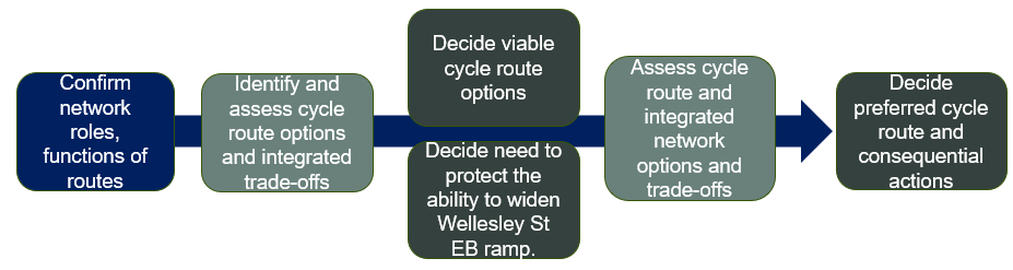
Figure 3-1 summarises the process adopted for this study. An important first step in the study has
been the confirmation of network roles and function. The criticality of this section of Wellesley to traffic
and buses means that there is a need to ensure that the preferred cycle route and any proposed
investment in cycle facilities considers the trade-offs with the performance of other network functions.
Figure 3-1: Methodology
The method also needs to consider the potential to widen the eastbound ramp connecting Wel esley
Street to Symonds Street. This link current only allows left turns only into Symonds Street and has
some resulting inefficiencies in the bus network. Any widening of this ramp, should it be proposed,
would occupy same space as the proposed NZTA/ANO cycle connection.
The work to deliver this assessment has included obtaining input from a number of subject matter
experts from across AT and Council, including:
◼ Council – AUDO
◼ Cycling design and planning
◼ Traffic/network operations
◼ Public transport operations
◼ Transport Strategy, including parking and servicing
4
Network assessment – confirm network roles and functions
4.1
Traffic,
goods and services
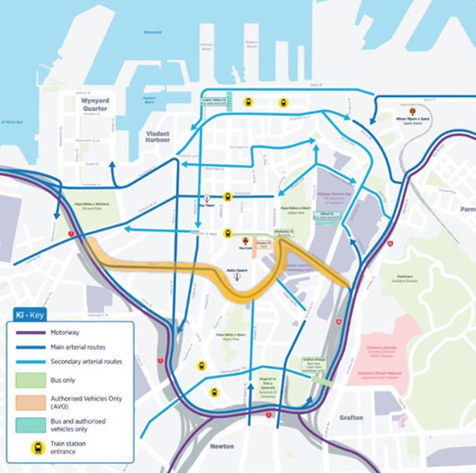
Under the CCMP, the Cook/Mayoral/Wellesley route
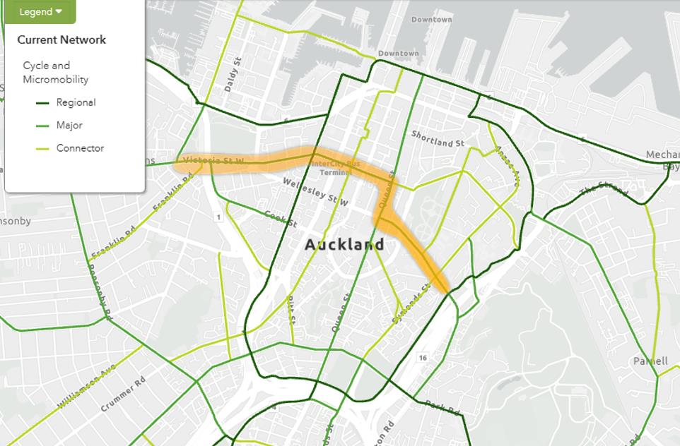
(Figure 4-1) is the only prioritised east–west traffic
corridor through the city centre which places a high reliance on the route for important functions, noting
other routes also retain a traffic function. Its role is critical for servicing, deliveries, access to parking and
mobility spaces, and pick-up drop-off due to its connection with State Highway 1 and State Highway 16
Project 530992 File 530992-W00001-MEM-TI-0001.docx
2026-04-29 Revision A
Page 2
link to page 3

ramps and its link with Grafton Road, Hobson Street and Nelson Street. The intention of this corridor is
to be designed and operated as a general traffic-oriented route, general y with four lanes in each
direction, plus turn lanes. The efficient operation of this route is essential to enable other east-west
routes to be prioritised as bus corridors and for places for people walking, cycling and local traffic access
to parking.
Figure 4-1: Main east-west traffic route
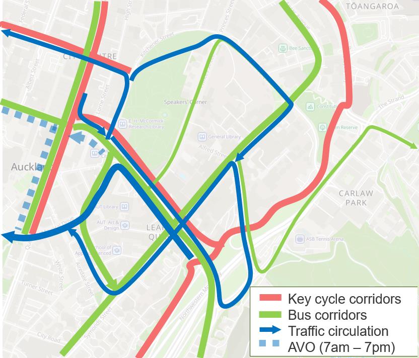
The section of Wellesley Street considered in this memorandum is also an important outlet for traffic
diverted from Queen Street as a result of the AVO on Queen Street and Wel esley Street West. With
the AVOs in place on Queen Street and Wel esley Street West, traffic southbound on Queen Street is
forced to turn left into Wel esley Street. Without a right turn into Mayoral Drive, the required routes for
people to make their journeys is complex
(Figure 4-2).
Figure 4-2: Traffic circulation with no right turn from Wellesley Street to Mayoral Drive
Project 530992 File 530992-W00001-MEM-TI-0001.docx
2026-04-29 Revision A
Page 3
link to page 4 link to page 4

However, there is also a high volume of buses using Mayoral Drive between Wel esley Street and
Wakefield Street, with a bus-only right turn from Wel esley Street into Mayoral Drive. This provision for
buses clashes with the identified traffic function. This conflict between bus and traffic networks results
in some general traffic travelling further and on lower-volume local streets, undermining the network
planning and reducing the ability to enhance those local streets.
4.2
Buses
Wel esley Street is a bus corridor of the highest order, being one of two east-west corridors provided for
in the City Centre Bus Plan (CCBP). In this regard, with the reliance that the city centre has on buses
as the largest public transport mode and limited additional capacity in the road network serving the city
centre, the efficient operation of Wel esley Street is critical to the city centre’s overall transport capacity
and ability to grow.
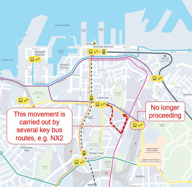
Wel esley Street provides direct access to the Te Waihorotiu Station, Universities as wel as bus and
rapid transit services on Albert Street
(Figure 4-3).
Due to the inability to turn right from Wellesley Street to Symonds Street, there are compromises in the
bus network shown in
Figure 4-3 which are relevant to this investigation.
However, the arrangement of the network in the area means not all routes are able to solely follow
Wel esley Street as set out in the CCBP. High volumes of buses currently need to use parts of the
network not previously envisaged – Mayoral Drive and Wakefield Street – for movement, stops and
layover. This is due to a Grafton Gully bus facility not proceeding, and a planned Quay Park bus facility
unable to accommodate Midtown buses. No other viable alternative arrangement has been found.
This is contrary to Mayoral Drive’s role as the key east-west traffic corridor under the CCMP, and the
CCBP network.
Figure 4-3: Bus corridors in the city centre
The width (and intersections) of the eastbound ramp connecting Wellesley Street and Symonds Street
means buses cannot use it to turn right onto Symonds Street. It only allows low bus volumes to turn left,
and if there was a need for buses to turn right from the ramp, it is likely to need to be widened, which
risks clashing with adjoining space a cycle facility may use.
Project 530992 File 530992-W00001-MEM-TI-0001.docx
2026-04-29 Revision A
Page 4
link to page 6

However, the ramp arrangement does not currently preclude bus operations, nor would introducing a
right turn help to re-route buses off Mayoral Drive. The benefit of a future widening of the ramp is unclear
at this stage.
4.3
Active modes
Pedestrians are considered a priority in all places in the city centre with major routes being identified in
the City Centre Master Plan on Te Hā Noa, Queen Street and the laneway network. Major public
transport routes and streets within the city centre are key pedestrian generators, bringing high volumes
of people into the city as bus passengers and creating strong pedestrian movement and access
demands along these corridors.
Cycle routes are proposed in a hierarchy from Regional (highest), Major and Connector (lowest) routes.
Regional cycling connections are available on the northern and southern edges of the city centre on
Quay Street and through Central Motorway Junction connecting north-south routes on Nelson Street
and Grafton Gul y. Queen Street provides a mid-town north-south Major connection and Te Hā Noa
provides a mid-town east-west Major connection between Nelson Street (and areas to the west) and
Grafton Gully. Due to the topography of the area and the location of Albert Park, the “Major” cycle link
between Te Hā Noa’s eastern extent and Grafton Gully is shown as a Queen Street-Wellesley Street
link, noting other routes are also proposed.
Figure 4-4: AT Future Connect Strategic cycle network showing “Major” east-west connection
In the context of the wider proposed cycle network, the “Major” link shown between Grafton Gul y and
Te Hā Noa is likely to serve:
◼ Key catchments to the east and west of the city centre for those travel ing to/from a midtown and
Learning Quarter zone
◼ People trying to access Victoria Quarter and destinations from Parnel
These are important movements, with most other trips would be met by other elements in the proposed
cycle network
(Figure 4-5). Note that from a journey (origin/destination) perspective, this link does not
have to be on Wel esley Street.
Project 530992 File 530992-W00001-MEM-TI-0001.docx
2026-04-29 Revision A
Page 5
link to page 2

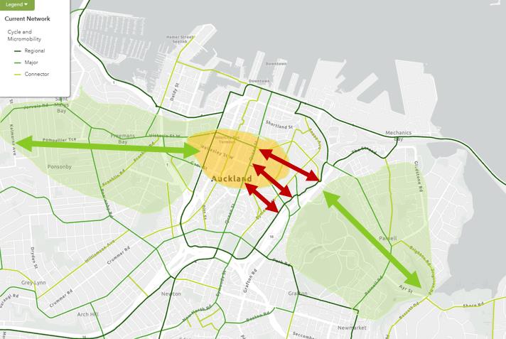 Figure 4-5: Cycle catchments and journey connections
In summary the Network Assessment concludes:
◼ There is a moderately important “Major” east-west cycle connection needed between the very
important “Regional” connections on the north and south edges of the city centre, linking Midtown
and the Learning Quarter with catchments east and west. This needs to link the Grafton Gully
“Regional” link with Victoria Street (Te Hā Noa)
◼ Wel esley is a very important bus corridor – one of only two east-west corridors in the city centre
and its function is compromised to an extent by the inability of buses to turn right from Wellesley
Street to Symonds Street.
◼ Wel esley is a very important traffic corridor – the only prioritised east-west corridor in the city
centre.
◼ Of note, there is no cycle route proposed on Wellesley Street, west of Queen Street, meaning
options other than Wel esley Street are possible to connect Grafton Gully with Te Hā Noa.
So, a cycle connection is important, but Wel esley Street’s importance as a bus and traffic corridor is
critical, and options other than Wellesley Street can be considered for the cycle link, in part or entirely,
as well as Wel esley Street.
5
Wellesley Street proposed improvements
5.1
Grafton Gully Cycleway Connection
NZTA has proposed building (but has not yet attained funding for) a separated shared path facility on
the north side of Wel esley Street between the Grafton Gully Cycleway and the intersection with Princes
Street as part of the Auckland Network Optimisation (ANO) programme which will give effect to the
planned cycle route. The proposed design is shown in Figure 5-1.
Given the conflicts outlined in section
4 and the possible future need to widen the eastbound ramp
connecting Wel esley Street with Symonds Street, this memorandum is intended to provide information
to a support a decision on whether or not to advise NZTA to proceed with this new section of
cycleway.
Project 530992 File 530992-W00001-MEM-TI-0001.docx
2026-04-29 Revision A
Page 6
link to page 7 link to page 2

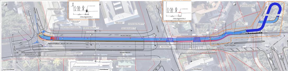
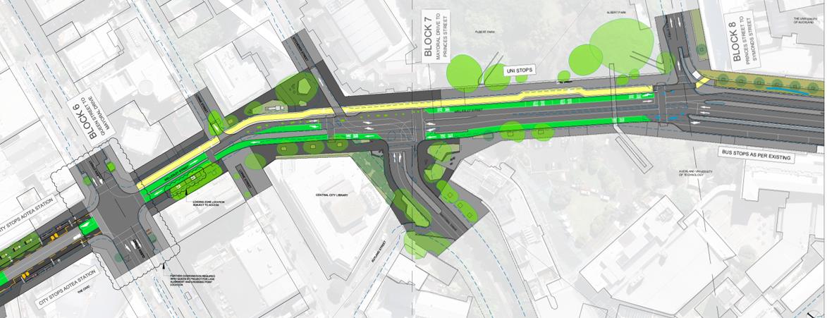 Figure 5-1: Proposed NZTA/ANO Grafton-Wellesley Cycleway Connection
5.2
Wellesley Street Bus Improvements Stage 3
Figure 5-1: Proposed NZTA/ANO Grafton-Wellesley Cycleway Connection
5.2
Wellesley Street Bus Improvements Stage 3
The continuation of the Wellesley Street Bus Improvements project east of Queen Street (Stage 3) is a
vital part of the city centre’s overall transport capacity and efficiency. An early concept is shown in
Figure 5-2, with design work expected to commence in 2027.
Figure 5-2: Wellesley Street Bus Improvements Stage 3 Concept (note - early concept only)
This plan, while very early and conceptual, il ustrates the conflicts and constraints in this section of
Wel esley Street. For example, considering the needs outlined in section
4, the plan includes:
◼ The strategy to provide a cycleway (shown in yel ow)
◼ The need to provide a bus right turn into Mayoral Drive from Wellesley Street to accommodate the
inability for buses to turn right at Symonds Street
◼ A westbound continuous bus lane
◼ Pedestrian and passenger waiting spaces
This arrangement also illustrates the challenges with providing for al required functions in the space
available, in that it does not provide:
◼ A continuous eastbound bus lane
◼ A traffic right turn into Mayoral Drive to provide for traffic diverted by the Queen Street AVO
◼ Two lanes of traffic in and out of Mayoral Drive to allow this important traffic route to be effective.
Resolving these issues and finding an optimal solution is complex with the need for design, operational
modelling and clear assessment of trade-offs.
Project 530992 File 530992-W00001-MEM-TI-0001.docx
2026-04-29 Revision A
Page 7
link to page 2 link to page 8 link to page 2 link to page 17

 6
Options assessment
6.1
Recognising traffic and bus network functions
6
Options assessment
6.1
Recognising traffic and bus network functions
This options assessment focuses on options for a safe cycle route. This is because the Network
Assessment in section
4 indicates that there are two critical functions of Wel esley Street that are of
high importance and that are supported by committed service and infrastructure delivery. The
assessment considers the following functions essential:
◼ The effective function of this section of Wellesley Street as a traffic route
◼ The effective function of Wellesley Street as a bus route
Options assessment, as a result has focused on the cycle route options to determine:
◼ If viable alternatives exist that deliver in the cycle network function; and
◼ whether, on balance considering all modes and functions, the alternative cycle routes are
preferable; or
◼ whether it is best to accommodate the cycle route on Wel esley Street.
6.2
Considering the route in two sections
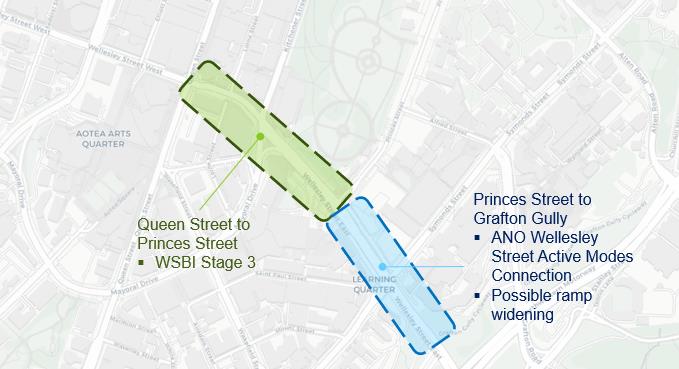
For the purposes of this assessment, Wel esley Street improvements can be broken into two sections
(Figure 6-1) as the decision on the east section enables different options for the west section.
◼ West (Queen Street to Princes Street); and
◼ East (Princes Street to Grafton Gul y) – the section where ANO propose to implement a new cycle
facility.
Figure 6-1: Wellesley Street proposed works
The two sections are related as there is a continuity of functional requirements described in section
4,
but can be considered distinctly because:
◼ There is greater urgency in the need to make a decision on the eastern section due to the potential
Grafton Gul y Cycleway and the intersection with Princes Street as part of the Auckland Network
Optimisation (ANO) programme.
◼ There are differing alternatives for a safe cycle route depending on decisions for each section,
described in sectio
n 7).
Project 530992 File 530992-W00001-MEM-TI-0001.docx
2026-04-29 Revision A
Page 8

The west section involves Wel esley Street Bus Improvements (WSBI) Stage 3. The design for this Stage
3 is unlikely to begin prior to 2027, currently envisaged to include a cycle path along the northern side
of Wellesley Street.
The east section of Wel esley Street has two main influences:
◼ A conceptual proposal to provide a bus link via the eastbound ramp from Wellesley Street to
Symonds Street in the future, to allow buses to turn right onto Symonds Street and improve
outcomes for bus operations in the area. A significant capital cost would be required to move the
retaining wal for the off-ramp expansion.
◼ The NZTA proposal, in detailed design phase for a Wellesley Street Active Modes Connection, a
shared path link from Princes Street to Grafton Gully. Space is available alongside the Symonds
Street underpass carriageway for this expansion.
The proposed Wellesley Street Active Modes Connection and the widened ramp noted above would
occupy the same road space. As a result, the decision regarding need to protect the ability to widen the
Wel esley Street ramp plays a crucial role in which cycle route is preferred.
6.3
Cycle route assessment
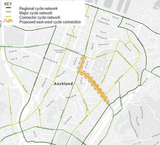
Five options were considered during the options assessment. Options 1,2 and 3 tie into the Wel esley
Street Active Modes Connection whilst options 4 and 5 provide alternative routes through the Learning
Quarter. Al options form part of the planned Future Connect cycle network, some as part of the Major
network and others as part of the lower order Connector network.
The cycle route options also sit within the Learning Quarter and consider streets that are important in
precinct plans being developed by Council and universities.
Currently proposed east-west cycle connection:
Figure 6-2: Option 1 (Wellesley Street)
Project 530992 File 530992-W00001-MEM-TI-0001.docx
2026-04-29 Revision A
Page 9

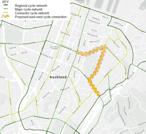
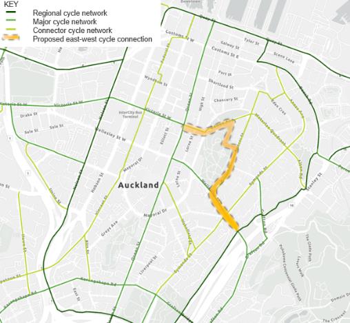
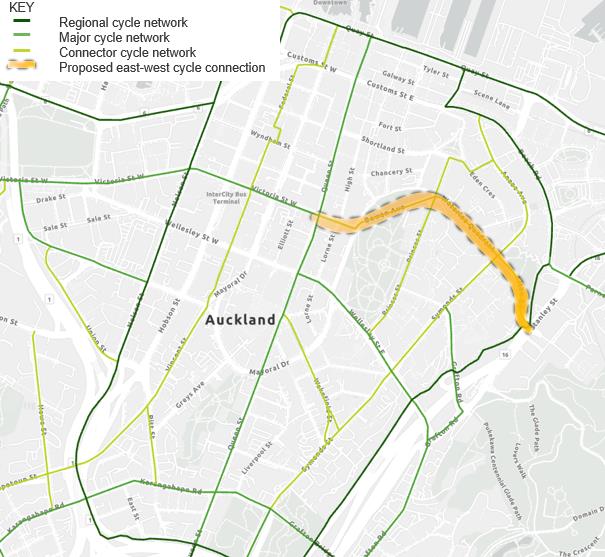
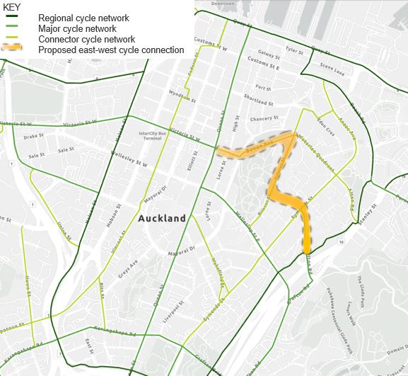 Cycle routes that utilise the Wellesley Street Active Modes Connection:
Figure 6-3: Option 2 (Wellesley, Princes, Bowen)
Figure 6-4: Option 3 (Wellesley, Princes, Albert
Park, Bowen)
Cycle routes that do not use the Wellesley Street Active Modes Connection:
Figure 6-5: Option 4 (Alten, Waterloo Quadrant,
Figure 6-6: Option 5 (Grafton, Alfred, Princes,
Bowen)
Bowen)
6.3.1 Multi-criteria assessment criteria
Cycle routes that utilise the Wellesley Street Active Modes Connection:
Figure 6-3: Option 2 (Wellesley, Princes, Bowen)
Figure 6-4: Option 3 (Wellesley, Princes, Albert
Park, Bowen)
Cycle routes that do not use the Wellesley Street Active Modes Connection:
Figure 6-5: Option 4 (Alten, Waterloo Quadrant,
Figure 6-6: Option 5 (Grafton, Alfred, Princes,
Bowen)
Bowen)
6.3.1 Multi-criteria assessment criteria
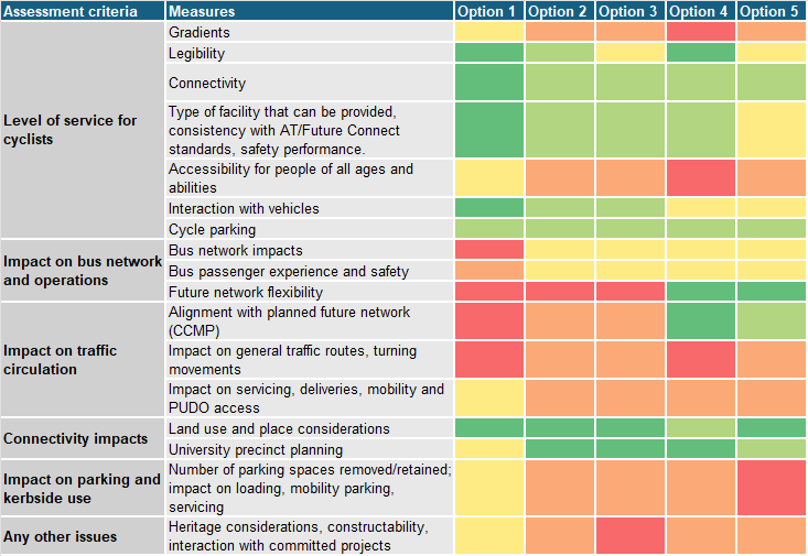
A Multi-criteria assessment (MCA) was carried out and assessed each option against the following
criteria:
•
Level of service for cyclists: gradients, length of climbs, legibility, conflicts, connectivity to
Strategic routes and destinations, facility type, and accessibility for a wide range of users.
•
Impact on bus network and operations: effects on reliability, layover locations, out-of-
service movements, passenger experience, and future network flexibility.
•
Impact on traffic circulation: consistency with CCMP intent, effects on key east–west
movements, and servicing access.
•
Connectivity and land-use integration: access to University precincts, Learning Quarter
destinations, and consistency with precinct plans.
•
Impact on parking and kerbside use: scale of parking removal, loading impacts, and
business effects.
Project 530992 File 530992-W00001-MEM-TI-0001.docx
2026-04-29 Revision A
Page 10
link to page 11

•
Other issues: heritage, constructability, staging and interaction with committed projects
(WSBI Stage 3, Te Hā Noa, ANO).
The outcomes of the MCA can be seen i
n Figure 6-7.
Figure 6-7: MCA summary
Large
Large
Scale
positive
negative
Project 530992 File 530992-W00001-MEM-TI-0001.docx
2026-04-29 Revision A
Page 11

 6.3.2 Option 1 – Grafton Gully to Queen Street via Wellesley Street
Option 1 connects Grafton
Gully to Queen Street/Te Hā
Noa via Wellesley Street and
Queen Street.
It utilises the proposed ANO
shared path connection up to
Princes Street and then joins
the proposed WSBI
bidirectional cycle path on
Wel esley Street before joining
Queen Street.
Advantages
Disadvantages
Notes
◼ Considered the best safe and
◼ Universal design/accessibility
◼ This is the current strategy
accessible cycle route (ANO
concerns regarding conflicts
◼ Leaves the eastern extent of
and WSBI designs)
with cyclists and bus
constructed Te Hā Noa
passengers – University bus
◼ Most direct and shortest route
disconnected from a protected
stops by Albert Park are an
for cycling
facility
important boarding/alighting
◼ Avoids the steepest sections in
location
◼ Does not allow for Wellesley
other options
Street ramp – impacting bus
◼ Reduces capacity for general
reliability and routing options
◼ Good connection to Grafton
traffic on Wel esley-Mayoral-
through Wellesley Street,
Road and the Auckland
Cook EW traffic route – poor
Mayoral Drive and Wakefield
Domain
CCMP alignment
Street
◼ Has the lowest delivery risk –
◼ Reduces capacity for bus
◼ There is already some level of
part of planned works
movements through Wellesley
cycle provision on Wellesley
– negative impacts on bus
◼ The WSBI design aligns with
Street (painted cycle lane)
reliability with current WSBI
the city centre approach for
design
slower cyclist speeds due to a
mix of activity through these
◼ Steep gradients limit access for
areas, as seen on Queen
all ages and abilities
Street
Project 530992 File 530992-W00001-MEM-TI-0001.docx
2026-04-29 Revision A
Page 12

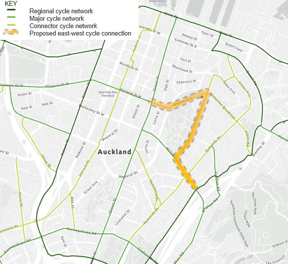 6.3.3 Option 2 - Grafton Gully to Victoria Street via Wellesley Street, Princes Street and Bowen
Avenue
6.3.3 Option 2 - Grafton Gully to Victoria Street via Wellesley Street, Princes Street and Bowen
Avenue
Option 2 connects Grafton
Gully to Queen Street/Te Hā
Noa via Wellesley Street,
Princes Street, and Bowen
Ave.
It utilises the proposed ANO
shared path connection up to
Princes Street and then joins a
proposed bidirectional cycle
path on Princes Street and
Bowen Ave (park side) before
connecting to Te Hā Noa.
Advantages
Disadvantages
Notes
◼ Adopts the best alternate cycle
◼ Steep connection to Victoria
◼ Uses the eastern extent of
alignment west of Princes
Street with existing/constructed
committed Te Hā Noa
Street (grades, quality)
Te Hā Noa connection
◼ Does not allow for Wellesley
(although this is already in
◼ Provides good access to key
Street ramp widening in near
place)
University areas/Albert Park
term
and good connection to
◼ Steep corner connection
◼ Princes Street is expected to
Grafton Road and the
Princes/Bowen
continue accommodating in-
Auckland Domain
◼ Steep gradients limit access for
service and out-of-service bus
◼ Aligns with future University
all ages and abilities
movements in the medium
Masterplan concept for Princes
term.
◼ Space constraints at the end of
Street (parking removal)
Bowen – rework of Kitchener
◼ Confident cyclists will Stil use
◼ Avoids Wellesley Street
Street intersection required
Wellesley Street to travel
between Princes and Queen to
to/from Queen Street
◼ Significant parking removal –
provide more capacity for key
Princes, Bowen (note this is
bus and general traffic
potential y a short-term issue
movements (in alignment with
as it is aligned with Strategy)
the CCMP)
Project 530992 File 530992-W00001-MEM-TI-0001.docx
2026-04-29 Revision A
Page 13

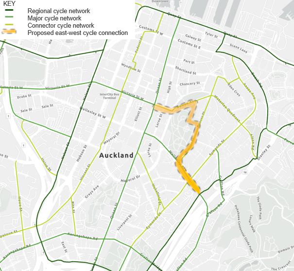 6.3.4 Option 3 - Grafton Gully to Victoria Street via Wellesley Street, Princes Street, Albert Park
and Bowen Avenue
6.3.4 Option 3 - Grafton Gully to Victoria Street via Wellesley Street, Princes Street, Albert Park
and Bowen Avenue
Option 3 connects Grafton
Gully to Queen Street/Te Hā
Noa via Wellesley Street,
Princes Street, and Bowen
Ave via Albert Park.
It utilises the proposed ANO
shared path connection up to
Princes Street and then joins a
proposed bidirectional cycle
path on Princes Street which
traverses through Albert Park
onto Bowen Ave before
connecting to Te Hā Noa.
Advantages
Disadvantages
Notes
◼ Provides good access to key
◼ Steep connection to Victoria
◼ Uses the eastern extent of
University areas/Albert Park
Street with existing/constructed
committed Te Hā Noa
and good connection to
Te Hā Noa connection
◼ Does not allow for Wellesley
Grafton Road and the
(although this is already in
Street ramp widening in near
Auckland Domain
place)
term
◼ Aligns with future University
◼ Steep gradients limit access for
◼ Princes Street is expected to
Masterplan concept for Princes
all ages and abilities
continue accommodating in-
Street (parking removal)
◼ Space constraints at the end of
service and out-of-service bus
◼ Avoids Wellesley Street
Bowen – rework of Kitchener
movements in the medium
between Princes and Queen to
Street intersection required
term
provide more capacity for key
◼ Significant parking removal –
bus and general traffic
Princes, Bowen (note this is
movements (in alignment with
potential y a short-term issue
the CCMP)
as it is aligned with Strategy)
◼ Uses a key Step‑free access
into Albert Park, reducing
availability for park users and
creating potential conflicts
◼ Lower route legibility in
park/shared spaces, requiring
greater reliance on wayfinding
and user behaviour
◼ Heritage impacts in Albert Park
from use of existing paths
Project 530992 File 530992-W00001-MEM-TI-0001.docx
2026-04-29 Revision A
Page 14

 6.3.5 Option 4 – Grafton Gully to Victoria Street via Alten Road, Waterloo Quadrant and Bowen
Avenue
6.3.5 Option 4 – Grafton Gully to Victoria Street via Alten Road, Waterloo Quadrant and Bowen
Avenue
Option 4 connects Grafton
Gully to Queen Street/Te Hā
Noa via Alten Road, Waterloo
Quadrant, and Bowen
Avenue.
The proposed protected
bidirectional cycle facility
begins at Alten Road,
continuing along Waterloo
Quadrant and Bowen Avenue
(park side) before connecting
to Te Hā Noa.
Advantages
Disadvantages
Notes
◼ Adopts the most direct route
◼ Alten Road connection is steep
◼ Uses the eastern extent of
(fewer turning moments)
but similar to the existing/in
committed Te Hā Noa
construction Te Hā Noa and
◼ Avoids Wellesley Street
◼ Allows for Wellesley Street
existing connection between
between Princes and Queen to
ramp widening in near term
Beach Road and Grafton Gully
provide more capacity for key
providing flexibility in bus
Cycleway
bus and general traffic
network operations and
movements (in alignment with
◼ Steep connection to Victoria
opportunities to take bus
the CCMP)
Street with existing/constructed
services off Mayoral Drive and
Te Hā Noa connection
Wellesley Street
◼ Aligned with future reduced
(although this is already in
traffic function of Alten Road
◼ Alternative Grafton Gully
place)
and Waterloo Quadrant in the
connection via Constitution Hill
CCMP
◼ Steep gradients limit access for
possible (some heritage
all ages and abilities
sensitivity to be further
reviewed)
◼ Less direct connection to
Grafton Road and the
◼ Alten currently plays a
Auckland Domain and further
significant role in connecting
away from AUT and UoA
car parks on High Street to the
facilities
motorway network
◼ Constraints at the end of
Bowen – rework of Kitchener
Street intersection required
◼ High delivery complexity,
requiring wider network and
circulation changes before
implementation due to
significant Street changes
required (parking and traffic
lane real ocation)
Project 530992 File 530992-W00001-MEM-TI-0001.docx
2026-04-29 Revision A
Page 15

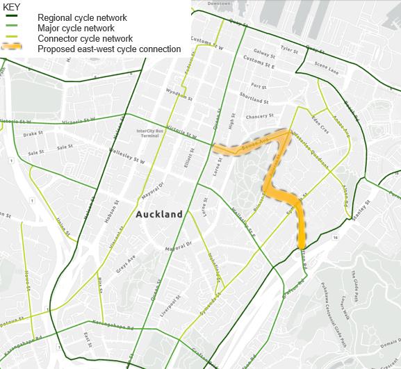 6.3.6 Option 5 - Grafton Gully to Victoria Street via Grafton Road, Alfred Street and Bowen
Avenue
6.3.6 Option 5 - Grafton Gully to Victoria Street via Grafton Road, Alfred Street and Bowen
Avenue
Option 5 connects Grafton
Gully to Queen Street/Te Hā
Noa via Grafton Road, Alfred
Street, and Bowen Ave.
The proposed protected
bidirectional cycle facility
begins at Grafton Road,
continues through the
Learning Quarter via Alfred
Street, Princes Street (park
side), and Bowen Avenue
before connecting to Te Hā
Noa.
Advantages
Disadvantages
Notes
◼ Good access to the Learning
◼ Steep connection to Victoria
◼ Uses the eastern extent of
Quarter, UoA City Campus.
Street with existing/constructed
committed Te Hā Noa
Limited access to AUT. Good
Te Hā Noa connection
◼ Allows for Wellesley Street
connection to Grafton Road
(although this is already in
ramp widening in near term
and the Auckland Domain,
place)
providing flexibility in bus
future cycle facilities on
◼ Steep gradients limit access for
network operations and
Symonds Street
all ages and abilities
opportunities to take bus
◼ Aligned with Strategy for Alfred
services off Mayoral Drive and
◼ Pedestrian–cyclist conflict risk
Street - expected to be
Wellesley Street
in shared and low‑legibility
pedestrianised under future
environments (e.g. Alfred
◼ Grafton Road is noted as a
University Masterplan
Street), with greater reliance on
Major cycle route, but our
◼ Avoids Wellesley Street
wayfinding and user behaviour
assessment indicates this
between Princes and Queen to
would be difficult to implement
◼ Constraints at the end of
provide more capacity for key
in alignment with the wider
Bowen – rework of Kitchener
bus and general traffic
CCMP Strategy
Street intersection required
movements (in alignment with
the CCMP)
◼ Significant parking removal –
Princes, Bowen (note this is
potential y a short-term issue
as it is aligned with Strategy)
◼ Difficult to accommodate
cycling within the constrained
road reserve, as lane removal
would conflict with Grafton
Road’s traffic role and require
significant tree removal
Project 530992 File 530992-W00001-MEM-TI-0001.docx
2026-04-29 Revision A
Page 16
 7
Findings and trade-offs
7.1
Preferred cycle route options
7
Findings and trade-offs
7.1
Preferred cycle route options
In a precinct like the university area, with numerous dispersed destinations for people on cycles across
the universities and midtown, it is likely that users wil , in practice take a range of the routes
considered, depending on where they are going and their level of confidence and ability. The focus of
this work is to identify a safe, al ages and abilities route that can be used as a spine for people to
make a range of journeys and importantly to connect the Te Hā Noa cycleway with the Grafton Gully
Cycleway.
Overall,
Option 1 (Wellesley Street) is the most direct, least steep and most legible for cyclists.
However, the route has the following risks and trade-offs:
◼ West of Princes Street the route has potential conflicts between cyclists and bus passengers and
pedestrians at busy bus stops and on pathways.
◼ West of Princes Street, this option introduces limitations to the space available in the street to
provide for important traffic and bus functions.
◼ East of Princes Street the option may reduce the potential performance of Wel esley Street,
affecting one of the city’s busiest bus corridors with potential wider network impacts on buses and
traffic.
◼ The option would not protect the future ability to widen the eastbound ramp from Wel esley Street
to Symonds Street with consequences for ongoing bus operations on Mayoral Drive and Wakefield
Street.
Option 2 (via Princes Street and Bowen Avenue) better aligns with future traffic and precinct plans
and improves access to the university, but involves steep gradients, parking removal, and stil does not
enable the future ramp widening and its ongoing consequences.
Option 4 (via Alten Road and Waterloo Quadrant) is a planned “Connector” cycle route and
provides a reasonably direction connection.
This would be the preferred route should the decision be made to retain the ability to widen the
eastbound ramp from Wel esley Street to Symonds Street. Option 4 has some potential risks:
◼ Steep gradients and legibility issues for users.
◼ It is longer than Option 1 and Option 2.
◼ Delivery, design and acceptance risks including loss of significant kerbside parking on Waterloo
Quadrant.
7.2
Non-preferred cycle routes
Routes assessed that are not considered preferred are:
Option 3 through Albert Park due to potential impacts on the park and park users. Option 2 achieves
most of the benefits of this option and does not impact the park and its users.
Options 5 using Grafton Road and Alfred Street due to the important traffic function and constrained
form of Grafton Road, steep grades and potential conflicts with people in Alfred Street which is
intended to function as a shared space.
7.3
Direction with regard to the Wellesley-Symonds eastbound ramp
The operational and physical outcomes of widening the ramp were investigated in 2025 (Wellesley
Street off-ramp (Long-Term layout), 526568-050DRP-NOT-MC-0003) as part of the City Centre Bus
Project 530992 File 530992-W00001-MEM-TI-0001.docx
2026-04-29 Revision A
Page 17
link to page 18 link to page 18

Plan (CCBP) business case. This paper identified the possible physical solution and operational
performance associated with buses turning right from and widening of the ramp.
This report confirmed that the ramp is suitable, with minor alterations at Princes Street for only a low
number of bus movements per hour, and only for services turning left into Symonds Street. If a higher
number of buses or right-turning was required, it is expected that the ramp would need to be widened,
which is expected to cost in the vicinity of $17
m1 and impact on the space available in the adjoining
underpass for other uses, including the proposed NZTA/ANO shared path project. There would also be
potential impacts on the layout and operation of the Symonds Street/Wellesley Street ramp
intersection which may impact efficient bus and traffic movements.
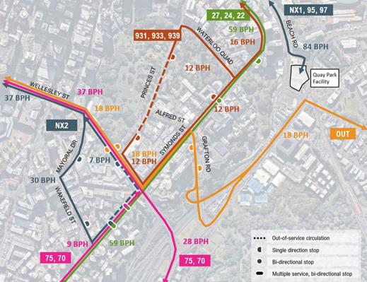
CCBP service pattern
Figure 7-1 shows the proposed service pattern for buses with the eastbound ramp from Wel esley
Street to Symonds Street remaining its current width. Of note, the key compromises are:
◼ The NX2 route using Mayoral Drive and Wakefield Street to complete its route and commencing
again on Wellesley Street; and
◼ The 70 and 75 routes having a different route to enter and exit the city centre.
Figure 7-1: CCBP Service pattern
NX2 Services
The NX2 service had previously been expected to utilise an off-street layover, either Quay Park which
is considered too far away and with insufficient capacity or a Grafton Gully facility no longer planned.
The interim arrangement is for NX2 buses, as wel as 82, 802, 923, 924 buses to use Mayoral Drive
and Wakefield Street to complete their route and access layovers and the westbound ramp to
Wel esley Street to commence their return route. This has some conflict with the strategic intent of
Mayoral Drive being the main east-west midtown traffic route. There appears to be no viable
alternative to this arrangement within the next 10-year horizon with no planned infrastructure solution
1 Wel esley Street off-ramp (Long-Term layout), 526568-050DRP-NOT-MC-0003, May 2025.
Project 530992 File 530992-W00001-MEM-TI-0001.docx
2026-04-29 Revision A
Page 18

and no economical y sustainable alternative termination location. Therefore, although not original y
part of the CCBP, AT is of the view that that the current NX2 route/layovers should be adopted as the
ongoing operational arrangement, acknowledging that this is not as legible for customers and
represents a compromise on the CCBP.
930 and OuterLink Services
It is expected that there wil be increasing pressure and desirability to move the 930-series services
and OuterLink away from their current routes within Auckland University’s precinct and instead use the
eastbound Wel esley Street slip lane ramp, with a left-turn into Symonds Street. As this is a low
number of buses per hour, and on the basis that other vehicle traffic on the ramp with be low or
manageable, AT intends to open discussions with the University of Auckland about when and how this
could occur, in support of campus improvements planning. This arrangement would also be adopted in
the CCBP.
70 and 75 services
There is the potential for the 70 and 75 services to use the eastbound slip lane ramp, which would
simplify the network, however, there does not currently appear to be sufficient patronage benefit to
justify the likely associated infrastructure costs as a widening of the eastbound ramp for the additional
bus volumes and right-turns would be required. It is recommended the current 70 and 75 routes
remain and be confirmed in the CCBP.
Future WX2 services
There is also the potential for a future WX2 (service to Westgate) service to similarly use the
eastbound ramp. As with the 70/75 routes, this additional volume of buses would likely trigger
infrastructure to widen the ramp, to create more space. Whilst a new WX2 service is expected in the
future, there is no confirmed date for this, as it relies on the implementation of significant enabling
infrastructure around Ian McKinnon Drive and State Highway 16. Even when this is in place, there are
several options for the WX2 routing within the city centre, so it is not considered that a future WX2
service can be relied upon as requiring the use of the ramp. It is recommended that the WX2 routing
be considered in more detail once a likely start date is known.
Summary
While there are some benefits in the widening of the eastbound ramp to al ow 70, 75 and possibly in
the future, WX2 buses to turn right, the direction is that the widening of the ramp is not currently
considered necessary, given the low level of benefits that have certainty, compared to the high cost
and high degree of certainty associated with the NZTA/ANO proposal to implement the Wellesley
Street Active Modes Connection. This is further supported by the assessed advantages for cyclists in
the Wel esley Street option (east of Princes Street) and risks with the Alten Road option (Option 4)
which would be required should the ramp be widened.
For clarity, there are trade-offs in this direction as the ramp widening would reduce reliance on Mayoral
Drive and Wakefield Street for bus circulation.
7.4
Preferred cycle route east of Princes Street and implications
Given the above assessment, the preferred cycle route between Grafton Gully Cycleway and Princes
Street is Wellesley Street.
Project 530992 File 530992-W00001-MEM-TI-0001.docx
2026-04-29 Revision A
Page 19
link to page 20 link to page 23

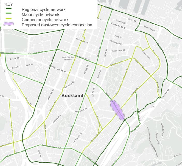 Figure 7-2: Recommended route for eastern section
The main reasons for this are:
◼ It is the intended route in published planning document and strategies.
◼ It is most direct for cyclists with most manageable gradients.
◼ There is a project to implement the cycle route with a high level of confidence which would improve
cycle access and safety in a part of the city centre that has a current gap in provision.
◼ The benefits resulting from a potential widening of the ramp for buses are not considered significant
in the foreseeable future and larger future benefits are uncertain.
This requires a compromise with the intended CCBP bus pattern – although as noted above, this is
considered acceptable and as a result the issue is less complex than the Princes Street to Queen
Street section. The decision on this section of the route is also more urgent with the potential for the
proposed NZTA/ANO cycleway connection and specific direction is required.
7.4.1 Remaining issues and risks resulting from this direction
While the compromise in the CCBP noted above is acceptable in principle from a bus operational
perspective, this direction creates greater pressure on:
◼ The eastbound right turn for buses from Wel esley Street to Mayoral Drive – also possibly required
for southbound traffic forced to turn left from Queen Street into Wel esley Street.
◼ The section of Mayoral Drive between Wellesley Street and Wakefield Street – part of a critical
traffic route and would need to retain some bus priority.
◼ Wakefield Street, as it would need to continue to function as an important bus connector with
layover for end of route buses.
These issues would need to be resolved and are discussed further in sectio
n 7.5 and 8.
7.5
Preferred cycle route west of Princes Street and implications
The direction above to implement a cycleway from Grafton Gul y as far as Princes Street on Wel esley
Street leaves two options open for consideration for the remainder of this cycle connection:
Project 530992 File 530992-W00001-MEM-TI-0001.docx
2026-04-29 Revision A
Page 20
link to page 2

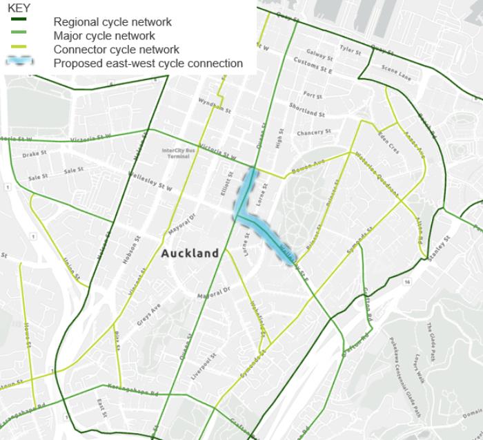
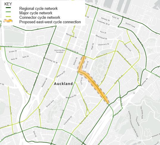
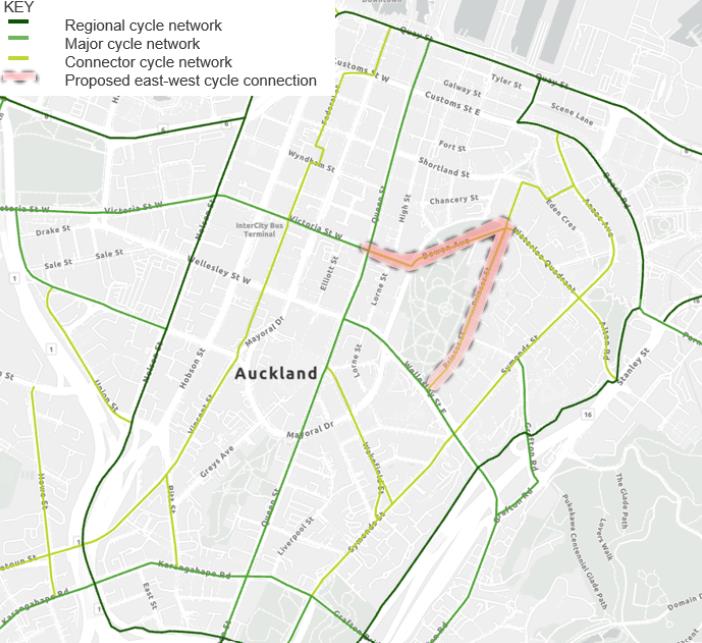 Option 1 – Wellesley Street to Queen Street, using Queen Street to connect with Te Hā Noa
Figure 7-3: Option 1 - Wellesley Street to Te Hā Noa via Queen Street
Option 2 – using Princes Street and Bowen Avenue to connect with Te Hā Noa
Figure 7-4: Option 2 - Wellesley Street to Te Hā Noa via Princes Street and Bowen Avenue
Option 1 – Wellesley Street to Queen Street, using Queen Street to connect with Te Hā Noa
Figure 7-3: Option 1 - Wellesley Street to Te Hā Noa via Queen Street
Option 2 – using Princes Street and Bowen Avenue to connect with Te Hā Noa
Figure 7-4: Option 2 - Wellesley Street to Te Hā Noa via Princes Street and Bowen Avenue
Key trade-offs in this decision are:
Option 1 is the preferred route from a cyclist’s perspective with lesser gradients, less distance and
more directness
. However, this route would require street space that places considerable pressure on
the core function of this section of Wel esley Street (refer section
4). While some of these issues could
be resolved through further design, there is at this time, considerable unresolved risk in relation to the
following functions:
◼ Space for a continuous bus lane eastbound between west of Lorne Street and east of Kitchener
Street.
Project 530992 File 530992-W00001-MEM-TI-0001.docx
2026-04-29 Revision A
Page 21
link to page 19

◼ Space for a possible traffic right turn from Wellesley Street eastbound into Mayoral Drive, noting
the diversion required by the northbound AVO on Queen Street north of Wel esley Street.
◼ Space for adequate traffic capacity and performance connecting Wellesley Street to Mayoral Drive
as part of the Mayoral Drive east-west traffic route.
◼ Conflicts between cyclists and bus passengers at the busy bus stop outside Albert Park on
Wel esley Street.
Option 2 is a good route for cyclists that avoids the issues noted above and provides better access to
key university destinations on Princes Street. A cycle route on Princes Street is well aligned with the
University of Auckland’s intended future function of Princes Street as a park-edge street for active
modes.
An advantage of this option is that it would use the eastern extent of the recently constructed Te Hā
Noa cycleway (east of Queen Street) improving legibility and avoiding the Te Hā Noa route terminating
abruptly at Kitchener Street.
This option leaves more space in Wellesley Street, west of Princes Street for accommodating
important traffic and bus functions.
This option has the following risks and issues:
◼ It is not completely aligned with the previously published planned cycle route.
◼ It is a longer route than Option 1 for cyclists accessing midtown and Te Hā Noa.
◼ There is a steep grade at the eastern extent of Te Hā Noa/Victoria Street – although it is noted that
this section of cycleway is already constructed.
◼ There is some parking removal required on Bowen Avenue with associated risks.
7.5.1 Remaining issues and risks in the section west of Princes Street and surrounding area
There are some significant trade-offs outlined above and unresolved risks inherent in any
recommended direction in this section. The issue is complex and any decision as to the preferred
outcome will need to include analysis and design to ensure that the risks and issues have properly
considered as well as stakeholder engagement, particularly with the universities.
The need to resolve this issue is less urgent than the section of Wel esley Street east of Princes Street
and there is time to carry out the required assessment and design to develop an optimal solution.
Resolution of these issues will need to include the effective function of this section of Wellesley Street
as a traffic route and bus route, specifical y:
◼ Space for a possible traffic right turn from Wellesley Street eastbound into Mayoral Drive, noting
the diversion required by the northbound AVO on Queen Street north of Wel esley Street.
◼ Space for adequate traffic capacity and performance connecting Wellesley Street to Mayoral Drive
as part of the Mayoral Drive east-west traffic route.
◼ Conflicts between cyclists and bus passengers at the busy bus stop outside Albert Park on
Wel esley Street.
◼ The effective function of Wellesley Street as a bus route, including space for a continuous bus lane
eastbound between west of Lorne Street and east of Kitchener Street and capacity for buses to
turn right from Wellesley Street to Mayoral Drive.
◼ The implications on Mayoral Drive of the ongoing need for buses to use Mayoral Drive and
Wakefield Street to accommodate the inability to turn right from Wel esley Street to Symonds Street
(a result of the proposed direction in the section east of Princes Street in sectio
n 7.4)
Project 530992 File 530992-W00001-MEM-TI-0001.docx
2026-04-29 Revision A
Page 22
 8
Draft recommendations and actions
8
Draft recommendations and actions
As a result of this work, there are a number of recommendations to be consulted on and advanced.
8.1
NZTA cycleway project proceeds on Wellesley Street, east of Princes Street
Reasons:
Between Grafton Gully and Princes Street, Wellesley Street remains the preferred and the most viable
option for cycling, because:
◼ This is the route identified in published planning documents.
◼ It is the most direct and legible for cyclists with the most manageable gradients.
◼ There is greater certainty that cycling facilities can be delivered (NZTA proposal exists).
Trade-offs:
◼ There is no futureproofing for ramp widening for potential future right turning bus movements.
Recommended action:
◼ NZTA to proceed with their project.
◼ NZTA project is scoped to ensure a practical and safe tie-in for buses, traffic, pedestrians and
cyclists at the Wel esley Street and Princes Street intersection.
8.2
Wellesley Street ramp widening for buses is not futureproofed for
Reasons:
Future proofing to widen the ramp is not required because:
◼ There is uncertainty about future bus operational requirements.
◼ Benefits for buses being able to make a right turn onto Symonds Street are unclear. This appears
useful but creates chal enges, and the operational movement has alternatives in the network.
◼ Left turns by buses onto Symonds continue to be enabled, allowing a potential shift of buses off
Alfred Street, aligning with University of Auckland proposals.
Trade-offs:
◼ Risks being unable to achieve future bus right turn, if needed.
◼ Buses on the ramp pass close to sensitive University of Auckland Science building.
Recommended action:
◼ Use of the ramp and left turn onto Symonds Street by buses to be enabled.
◼ Discussions commence with the University about buses using the ramp, with potential removal
from Alfred Street.
8.3
Continue bus movements on Mayoral Drive and Wakefield Street
Reasons:
◼ Buses need to use Mayoral Drive because there is a lack of alternative layover locations in
Learning Quarter/Grafton Gully.
◼ This is not due to the lack of a right turn on the Wellesley Street eastbound ramp.
Trade-offs:
◼ Conflicts and al ocation of space between traffic and bus movements on Mayoral Drive.
Project 530992 File 530992-W00001-MEM-TI-0001.docx
2026-04-29 Revision A
Page 23
 Recommended action:
◼ The CCBP and related workstreams are to be updated to recognise this requirement.
◼ Investigate and confirm ongoing bus layovers in the area, identify opportunities to remove buses
from Mayoral Drive.
8.4
Investigate remaining modal priority challenges on Wellesley Street between Princes
Street and Queen Street
Reasons:
◼ Significant unresolved network conflicts remain on Wellesley Street west of Princes Street, due to
multiple modes sharing the limited space and the need for movements not currently provided.
◼ Resolving this is a key enabler for upcoming work – e.g. WSBI Stage 3 and DDP.
Trade-offs:
◼ Current strategic plans may have to be amended for one or more modes, or a desired modal
outcome may be unable to be achieved.
Actions:
◼ Investigation to confirm how bus, traffic, and cycling provision can be viably made in the section of
Wel esley Street between Queen Street and Princes Street.
◼ For cycling, this includes identifying a preferred cycle route between Princes Street and Te Hā Noa.
This investigation should result in an updated concept for Wel esley Street Bus Improvements Stage 3
and inform relevant strategies and operational plans.
This investigation should consider:
◼ Traffic circulation from Queen Street southbound, including into Mayoral Drive.
◼ The performance of the Wel esley Street-Mayoral Drive connection for traffic.
◼ The performance of Wel esley Street and the Wellesley Street-Mayoral Drive-Wakefield Street
circuit for buses.
◼ The operation, safety and customer experience for users of the eastbound bus stops on Wel esley
Street.
◼ The safety and experience for pedestrians in this area.
◼ The experience, safety and effectiveness of the route as a cycleway.
Project 530992 File 530992-W00001-MEM-TI-0001.docx
2026-04-29 Revision A
Page 24
