 Wellesley
Street East
Wellesley
Street East
Functionality assessment – emerging findings

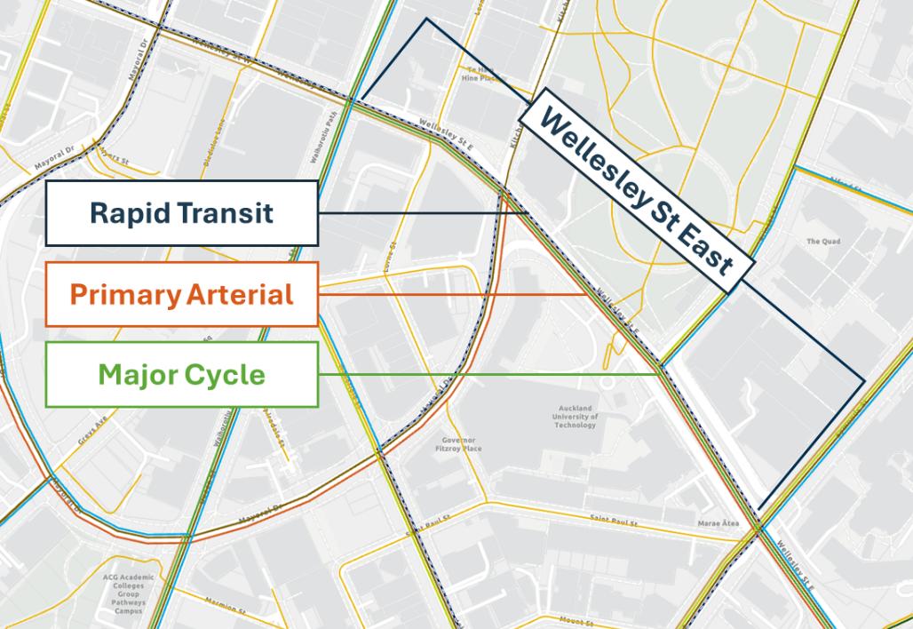 Context
• Wellesley Street is a key route for multiple modes, with
limited space and potentially overlapping projects
• Identified in both Future Connect and the CC Integrated
Transport Network (A4E)
Primary Bus
• NZTA have a project in design for cycling facilities along
Wellesley St and are awaiting a decision from AT as to
whether to proceed
• But to do this, AT needs to provide clarity on the
intended network function of Wellesley Street
• An investigation into this looked at:
1. Space constraints along the corridor impacting on
the ability to cater for proposed transport functions
2. The potential conflict between future bus and cycling
infrastructure, particularly on the eastbound access
ramp from Wellesley Street to Symonds Street
Investigations have been undertaken (with more detailed investigations still required for the Queen Street to Princes
Street section) to understand trade-offs, and to inform wider city centre transport network planning


 Cycling
Cycle Network Context
Cycling
Cycle Network Context
•
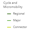
Wellesley Street is identified in Future Connect as a ‘Major’
cycle network connection
•
There is a need for a cycle connection of this magnitude to
connect between Te Hā Noa on Victoria St and Grafton Gully
cycleway.
•
There is a notable gap in the provision of this east-west
connection
•
However there are several possible alignments that could
address this gap
•
Wellesley Street/Queen Street is currently identified in Future
Connect.
•
The section between Princes Street and Queen Street will
need to be investigated further (given multiple constraints
and modal challenges in the area) before it can be
confirmed
•
NZTA have proposed a possible cycleway project along
Wellsley St from Grafton Gully to Princes St


 Bus routes and
movements
Bus Network Context
Bus routes and
movements
Bus Network Context
• Wellesley St is the highest order bus corridor in the city centre, and one of
only two east-west corridors provided for in the City Centre Bus Plan
(CCBP)
• However, the arrangement of the network in the area means
not all routes
are able to solely follow Wellesley St as set out in the CCBP
• High volumes of buses currently need to use parts of the network not
previously envisaged –
Mayoral Drive and Wakefield Street – for
movement, stops and layover
• This is due to a Grafton Gully bus facility not proceeding, and a planned
Quay Park bus facility unable to accommodate Midtown buses. No other
No longer
viable alternative arrangement has been found.
This movement is
proceeding
• This is contrary to Mayoral Drive’s role as the
key east-west traffic
carried out by
corridor under the CCMP, and the
CCBP network
several key bus
Use of Eastbound Sliplane Ramp
routes, e.g. NX2
• The width (and intersections) of the eastbound ramp means buses cannot
use it to turn right onto Symonds Street.
• It only allows low bus volumes to turn left, and if there was a need for buses
to turn right from the ramp, it is likely to need to be widened, which risks
clashing with adjoining space a cycle facility may use
• However, the ramp arrangement does not currently preclude bus operations,
nor would a introducing right turn help to re-route buses off Mayoral Drive
•
The benefit of a future widening of the ramp is unclear at this stage

 General traffic
and business access
General Traffic Network Context
General traffic
and business access
General Traffic Network Context
• Cook/Mayoral/Wellesley Street route is the key east–west traffic
corridor through the city centre, and should offer an effective and
legible route for drivers.
• Connects city centre arterials with State Highway 1 (from Cook Street,
Hobson Street, Nelson Street) and State Highway 16 (from Wellesley
Street) motorway ramps
• This allows traffic from other city centre arterial routes to circulate away
from streets focused on bus, cycle, or pedestrian movements
• However, there is also high volumes of buses using Mayoral Dr
between Wellesley St and Wakefield St, with a bus-only right turn from
Wellesley St into Mayoral Dr
• This provision for buses clashes with the identified traffic function
• Additionally, eastbound
traffic diverted from the Queen St AVO onto
Wellesley Street cannot access Mayoral Drive due to bus priority and
turn restrictions.
• This conflict between bus and traffic networks results in some general
traffic travelling further and on lower-volume local streets, undermining
the network planning and reducing the ability to enhance those local
streets.
 Recommendations
Recommendation
Reason
Trade-off
Recommended Action
Recommendations
Recommendation
Reason
Trade-off
Recommended Action
Between Grafton Gully and Princes Street, Wellesley
Street remains the preferred and the most viable
option for cycling:
• NZTA to proceed with their project
•
No futureproof for ramp
NZTA cycleway project
• Route in published planning documents
• NZTA project needs to ensure a practical
widening for future right
proceeds on Wellesley St,
and safe tie-in for buses, traffic,
• Most direct and legible for cyclists with the most
turning bus volumes
east of Princes St
pedestrians and cyclists at the Wellesley
manageable gradients.
Street and Princes Street intersection
• There is greater certainty that cycling facilities can
be delivered (NZTA proposal exists)
• Uncertainty in future bus operational requirements
•
Risks being unable to
• Unclear benefit for a right turn onto Symonds
• Use of ramp and left turn onto Symonds
achieve future bus right
Street – useful but creates challenges, and that
St by buses to be enabled
turn, if needed
Wellesley Street ramp
movement has alternatives in the network
• Discussions commence with University
widening for buses is not
•
Buses on ramp pass
• Left turns by buses onto Symonds to be enabled -
about buses using the ramp, with
futureproofed for
close to sensitive UOA
allows a potential shift of buses off Alfred St,
Science building
potential removal from Alfred St
aligning with Auckland University proposals
• Buses need to use Mayoral Drive because a lack
• The CCBP and related workstreams to be
of alternative layover in Learning Quarter/Grafton
•
Network conflict between
updated to recognise this requirement
traffic and bus
Continue bus movements
Gully
movements on Mayoral
• Investigate and confirm ongoing bus
on Mayoral Drive and
• This is not due to a lack of a right turn on the
Drive
layovers in the area, identify opportunities
Wakefield Street
Wellesley Street eastbound ramp
to remove buses from Mayoral Drive
• Significant unresolved network conflicts remain on
• Investigation to confirm how bus, traffic,
•
Current strategic plans
Wellesley St west of Princes St, due to multiple
and cycling provision can be viably made
may have to be amended
modes sharing the limited space and the need for
in the section of Wellesley St between
for one or more modes, or
Investigate remaining
movements not currently provided
Queen St and Princes St.
a desired modal outcome
modal challenges on
may be unable to be
• For cycling, this includes identifying a
Wellesley Street (Princes
• Resolving this is a key enabler for upcoming work
achieved
preferred cycle route between Princes
St to Queen St)
– e.g. WSBI Stage 3 and DDP
Street and Te Hā Noa
 PgCG decision – Wellesley St
Topic
Wellesley St sliplane
Discussion /
PgCG decision – Wellesley St
Topic
Wellesley St sliplane
Discussion /
• NZTA cycleway project proceeds on Wellesley St, east of Princes St
Update
• Wellesley Street ramp widening for buses is not futureproofed for
• Continue bus movements on Mayoral Drive and Wakefield Street
• Investigate remaining modal challenges on Wellesley Street (Princes St to Queen St)
Decision
PgCG to endorse the recommendations

Document Outline
