 RESOURCE CONSENT DECISION
Te Pirangi Developments Limited
RESOURCE CONSENT DECISION
Te Pirangi Developments Limited
Decision on an application for a resource consent to
undertake large-scale land disturbance
and the associated discharge of sediment at 4 Te Pirangi Way, Fitzherbert, Palmerston North.
Application Reference:
APP-2026205685.00
Decision Date:
27 March 2026
Expiry Date:
27 March 2031
 Application Summary
Proposal
Application Summary
Proposal
Te Pirangi Developments Limited (hereafter referred to as the Applicant) has applied for a resource consent
to undertake large-scale land disturbance for the purpose of residential development at 4 Te Pirangi Way,
Fitzherbert, Palmerston North. The proposed activity will take place on land legally described as Lot 2 DP
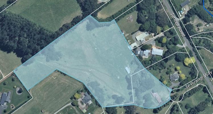
592670 and Lot 16 DP 599694 (hereafter referred to as the site), which has a total land area of 3.2069
hectares (3.2069ha), as shown in Figure 1 below.
The site has previously been used for a small farming holding. It is mostly grassed and has a general slope
away from Te Pirangi Way to the west of the site. The Applicant has obtained a subdivision consent to
segment the site into six (6) new rural residential lots from the Palmerston North City Council (PNCC).
Figure 1 – Site for the Residential Development Site at 4 Te Pirangi Way, Fitzherbert, Palmerston North.
Approximately 3,400 square metres (3,400m2) of land disturbance, with 300 cubic metres (300m3) of cut
and fill proposed. The purpose of the proposed work is to fill the site with suitable compacted fill material
to enable development within Lots 16, 17 & 18, remove the trees within Lots 2 & 14, and provide a right of
way (ROW) access.
The works are proposed to be undertaken in one stage, consisting of the construction of silt fencing removal
of trees, stripping and stockpiling of topsoil excavating and stabilising areas with metal, cut and fill
earthworks, and stabilising with topsoil and hydroseed.
The application includes an Erosion Sediment Control Plan (ESCP) for the proposed activity. Following a
request for additional information under Section 92 of the Resource Management Act (RMA) 1991, an
updated ESCP was provided on 6 March 2026.
The ESCP has been developed based on the following sequence of work, noting that some work has already
been completed:
Page
2 of
19
• Construct and stabilise construction entrance (already completed);
• Excavate Area B & stabilize with metal (already completed);
• Remove trees within Area A, topsoil & hydroseed (already completed);
• Strip Area C of topsoil & place in a stockpile (already completed);
• Place silt fence around Area A (underway);
• Place silt fences around Areas C & D;
• Strip Area D of topsoil & place in stockpile;
• Cut Area D and fill in Area C;
• Stabilise ROW in Area D with metal. Place silt fence on the lower side of Area B;
• Place power duct and stormwater pipes within Areas B & D and backfill trenches with metal.
Excavated material to be placed in Area C; and
• Stabilise earthworks in Area C with topsoil & hydroseed.
The Applicant has specified that the proposed works will begin in the summer construction season and are
expected to finish before the winter months. The works will take approximately six (6) weeks to be
completed. Prior to any further earthworks being undertaken, erosion and sediment control (ESC) measures
will be constructed and installed.
The site is located within the Manawatū Groundwater Management Area (GMA). The site is located within
the Lower Manawatū (Mana_11) Surface Water Management Area (WMA), and the Turitea (Mana_11b)
sub-area. The nearest waterway is the Turitea Stream, which is located approximately 185m north-east of
the site. The Turitea Stream has the One Plan (2026) Schedule 2 values of Trout Fishery, Trout Spawning,
and Life Supporting Capacity.
The Applicant has sought a consent duration of five (5) years.
Rule Assessment
Under section 88A of the Resource Management Act 1991, an application must be processed, considered
and decided as an application for the type of activity that it was for at the time the application was first
lodged.
As this proposal was accepted as complete in January 2026, when the operative planning instrument was
the One Plan (2025), its activity status and rule framework are fixed to that version. When making the
substantive decision under section 104, the Consent Authority must still have regard to any later planning
documents that exist; therefore, the Objectives and Policies of the amended One Plan (2026) inform the
policy assessment and weighting, even though they do not change the activity classification at the time of
lodgement.
The application notes that no imported material will be required to complete the proposal. Therefore, an
assessment of the proposal against the discharge of cleanfill rules of the One Plan (2025) is not considered
Page
3 of
19
necessary. It was clarified by in the request for additional information that the site is not considered to have
a slope of more than twenty (20) degrees. Therefore, it does not meet the definition of a Hill Country
Erosion Management Site and does not need to be assessed under Rule LF-LAND-R7 of the One Plan (2025).
Land Disturbance
The One Plan (2025) regulates small-scale land disturbance under Rule LF-LAND-R1 as a Permitted Activity.
This rule allows for the land disturbance of a total area up to 2,500m2 per property per twelve (12) month
period. As this proposal is for the disturbance of approximately 3,400m2, this proposal is unable to comply
with this rule. Therefore, this proposal is assessed under Rule LF-LAND-R6 as a
Controlled Activity.
It should be noted that for large-scale land disturbance under Rule LF-LAND-R6, the matters of control are
limited to:
1. The location, nature, scale, timing and duration of the activity;
2. Additional content of and the standard to which the
Erosion and Sediment Control Plan must be
prepared, the implementation of the plan, and the timing of when it must be prepared and
submitted;
3. The effects of the activity and associated sediment run-off on soil conservation, surface water
quality and aquatic ecology and the methods to be taken to avoid, remedy or mitigate them;
4. The provision of greater setback distances from waterbodies than those specified under Conditions
(4) and (5) to provide greater protection to a waterbody if required;
5. Duration of consent;
6. Review of consent conditions;
7. Compliance monitoring;
8. The matters in RP-LF-LW-P12.
Rule LF-LAND-R6 also contains the following non-notification clause
“Resource consent applications under
this rule will not be notified and written approval of affected persons is not required” and, therefore, this
application will be processed on a non-notified basis.
Activity Summary
The following activity is associated with this resource consent application:
Activity Description
Status
Authorisation Number
Land Use Consent, Land, Large-Scale One Plan (2025), Rule LF-LAND-R6, ATH-2026208888.00
Land Disturbance
Controlled Activity
Page
4 of
19
Assessment Summary
The application has been assessed against the following:
1.1
Environmental Effects – Section 104(1)(a) – Resource Management Act (1991)
The Resource Management Act (1991), under section 104(1)(a), states that when considering an application
for a resource consent, the Consent Authority shall have regard to any actual or potential adverse effects
on the environment prior to authorising the activity.
The application has been reviewed by
Mr Kerry Pearce, of Bryant Environmental Solutions Limited, on
behalf of the Manawatū-Whanganui Regional Council. Mr Pearce has assessed the application, and the
effectiveness of the erosion and sediment controls proposed for the site. Based on his considerations, the
actual and potential adverse effects on the environment of allowing the proposed activities have been
identified and are assessed below.
Actual and Potential Environmental Effects
Effectiveness of the Erosion and Sediment Controls
The proposal includes earthworks over an approximately 3,400 square metres (3,400m2) site, with 300
cubic metres (300m3) of cut and fill proposed. An Erosion and Sediment Control Plan (ESCP) was provided
as part of the application. Following a request for additional information under Section 92 of the
Resource Management Act (RMA) 1991, an updated ESCP was provided. Mr Pearce has assessed the
application documents and updated ESCP against current best practice, particularly the
“Erosion and
Sediment Control Guide for Land Disturbing Activities in the Wellington Region” dated February 2021
(hereafter referred to as the Guidelines).
The site is divided into Areas A, B, C and D, with the stabilised site entrance located in Area B. There is a
‘topsoil area’ indicated on the Plan in Appendix B of the ESCP, and it is located just outside of Section C,
but within an area controlled by a silt fence.
Clarification was sought through the additional information request regarding any controls being put in
place for earthworks to construct the right of way (ROW) and the services that would need to be installed
as there was no mentioned of this in the initial application documents. The Applicant clarified that there
would only be electricity provided as a service, along with trenching for stormwater. The trenching
material will be either disposed of offsite or in the fill area and these works will be controlled by the
proposed silt fencing.
Clarification was also sought regarding how Area C had already been stripped and topsoil stockpiled,
while the silt fencing (ESC for that area) has not yet been installed. The request also asked for a location
on where the topsoil has been stockpiled for Area C and where it will be stockpiled for Area D. The
Applicant stated in response that only a small part of Area C has been stripped, and an updated ESCP
was provided to show that area and the proposed topsoil stockpile.
There was also further clarification required regarding the placement of material that is proposed to be
excavated from Area D, which the Applicant clarified will be placed in Area C.
Page
5 of
19
Erosion and Sediment Controls
Mr Pearce notes that the primary erosion and sediment control (ESC) measures for the proposed
earthworks are minimising the disturbed area, utilising silt fencing for exposed areas, and rapid
stabilisation of disturbed areas.
Mr Pearce notes in Section 4.2 of the ESCP that all ESC measures will remain in place until earthworked
areas have been topsoiled and an eighty percent (80%) grass coverage has been achieved.
Silt fences will be placed around the periphery of the site. The ESCP identifies that these silt fences will
be required on the downhill site of all disturbed land. All the silt fences are to be constructed in
accordance with the sediment controls shown in Appendix C of the ESCP.
Winter Works
The Applicant has specified that the proposed works will begin in the summer construction season and
are expected to finish before the winter months. Mr Pearce notes that works outside of the summer
construction season are more susceptible to sediment discharge, therefore, he considers a seasonal
restriction is appropriate and has recommended conditions of consent to cover this.
Monitoring
The application states that the ESC measures will be inspected on the first working day of each week and
on the day following a rainfall event. A rainfall event has been defined as ten millimetres per hour
(10mm/hour) or twenty millimetres per twenty-four hours (20mm/24 hours). If an ESC measure is
identified as not operating correctly, then work will be ceased in the area, the catchment area will be
reduced, and then additional measures will be constructed.
Dust
Mr Pearce notes that there is a brief mention of dust control in the application, this being wetting down
exposed areas and stockpiles ‘as appropriate’. There are potential sensitive receivers with surrounding
housing and roading, however, there is no mention of specific dust control measures in the ESCP. Mr
Pearce has recommended the standard dust control conditions should be included.
Conclusion
Given the nature and type of earthworks to be undertaken, and taking into account any additional
recommendations noted above, Mr Pearce considers that the proposed controls will generally represent
industry best practice for ESC and Guidelines standard. Mr Pearce considers that any runoff from the site
will be of an appropriate standard prior to being discharged off site.
Provided all ESC measures are constructed and maintained in general accordance with the documents
provided to Council and the Guidelines, and the recommended conditions of consent are implemented,
Mr Pearce considers the resulting effects on the environment from the works will be appropriately
managed. Therefore, the potential adverse effects of the proposed activity on the environment are less
than minor.
Page
6 of
19
Conclusion
Based on the assessment by Mr Pearce, I am satisfied that the potential adverse effects on the environment
of the proposed large-scale land disturbance can be appropriate managed, and the effects are considered
to be less than minor.
1.2
Relevant Provisions – Section 104(1)(b) – Resource Management Act (1991)
The Resource Management Act (1991), section 104(1)(b), states that when considering an application for a
resource consent, the Consent Authority shall have regard to any relevant provisions before authorising the
activity.
Relevant Provisions
National Environmental Standard for Sources of Human Drinking Water (2007)
Regulation 11
Resource Consents with the Potential to Affect Certain Drinking-Water Supplies
Regulation 12
Condition on Resource Consent if Activity may Significantly Adversely Affect
Registered Drinking-Water Supply
National Environmental Standard Considerations
The National Environmental Standard for Sources of Human Drinking Water (NES-HDW) 2007 is a
regulation under the Resource Management Act (1991) that sets requirements for protecting sources of
human drinking water from being contaminated.
Regulations 11 and 12 of the NES-HDW (2007) outline that an activity that has the potential to affect a
registered drinking water supply source that provides no fewer than 25 people with drinking water for
not less than 60 days each calendar year is required to be considered by decision makers.
The nearest registered drinking water source that supplies a population of 25 or more people is the
Massey University Sheep and Beef Farm supply, which lies approximately 660 metres (660m) west of the
site. The supply type is unknown and supplies a population of 70.
Conclusion
Provided the land disturbance is undertaken in accordance with the consent application and
recommended condition schedule and given the distance to the closest registered drinking source and
small supply population, it is considered that this activity will not affect this drinking water supply.
Overall, I consider this proposal is consistent with Regulations 11 and 12 of the NES-HDW (2007).
National Policy Statement for Freshwater Management (NPS-FM) 2020 – Amended 2025
Policy 1
Freshwater Management gives effect to Te Mana o te Wai
Policy 3
Land Use, Catchment & Receiving Environment Effects
Policy 15
Social, Economic & Cultural Well-being
National Policy Statement Considerations
The National Policy Statement for Freshwater Management (NPS-FM) 2020 was introduced in 2020 and
replaces the previous NPS-FM 2017. The revised NPS-FM came into effect in September 2020 and was
last amended in December 2025.
Page
7 of
19
The NPS-FM (2020) directs Resource Managers, in this case Manawatū-Whanganui Regional Council, to
safeguard the life supporting capacity and the health of the people and communities, by sustainably
managing the use and development of land and of the discharge of contaminants. Policies 1, 3, and 15
are considered relevant to this application.
Policy 1 seeks to ensure freshwater is managed in a manner that gives effect to Te Mana o te Wai. Te
Mana o te Wai is a concept that recognises the value of protecting the health and wellbeing of freshwater
and the wider environment. Provided the activity is undertaken in accordance with the consent
application and the recommended conditions of consent, I am of the opinion that the proposed activity
will not adversely affect the health and wellbeing of freshwater. Therefore, I consider the proposal to be
consistent with Policy 1.
Policy 3 seeks to manage freshwater in a manner that considers the effects of the use and development
of land on a whole-of-catchment basis. The proposed activity is located within the Manawatū Catchment.
Based on the advice provided by Mr Pearce in the above Section 1.1 titled
‘Environmental Effects’, I am
of the opinion that the effects of the proposed activity will be less than minor and therefore, I consider
the proposal to be consistent with Policy 3.
Policy 15 seeks to ensure that communities are enabled to provide from their social, economic, and
cultural wellbeing in a manner that is consistent with the NPS-FM (2020). The proposal relates to the
development of new residential lots at the property. This provides for the social and economic wellbeing
of the Applicant, and the future homeowners. On this basis, I consider the proposal to be consistent with
Policy 15.
Conclusion
Overall, I am of the opinion that, provided the activity is undertaken in accordance with the consent
application and recommended conditions of consent, the proposal is in accordance with the relevant
Policies of the NPS-FM (2020).
One Plan (2026) Regional Policy Statement
LF-LAND-O1
Managing Accelerated Erosion
LF-LAND-O2
Regulating Potential Causes of Accelerated Erosion
LF-LAND-P2
Regulation of Land Use Activities
LF-LAND-P3
Supporting Codes of Practice, Standards, Guidelines, Environmental Management
Plans and Providing Information on Best Management Practices
LF-FW-O3
Water Management Values
LF-FW-P4
Water Management Areas and Values
Regional Policy Statement Considerations
LF – LAND – Land
The Objectives and Policies in the Land chapter of the Regional Policy Statement seeks to ensure that
human activities on land are managed in a manner that reduce the potential for adverse environmental
effects on land specific to accelerated erosion.
Page
8 of
19
Objective’s LF-LAND-O1 and LF-LAND-O2 and Policy LF-LAND-P2 seek to manage potential causes of
accelerated erosion from land disturbance, minimise the risk of accelerate erosion, and minimise the
discharge of sediment to water. The proposal has been assessed in combination with the ESC measures.
Based on the assessment by Mr Pearce, and the recommended consent conditions, the proposal is
considered to be consistent with this Objective and Policy.
Policy LF-LAND-P3 seeks to support codes of practice, standards, guidelines, environmental management
plans and providing information on best management practices. The proposed activity must be
established and maintained in accordance with best practice and the ESCP. Based on Mr Pearce’s
assessment, and provided the proposed activity is undertaken in accordance with the information
provided in the application, I consider the proposed activity to be consistent with this Policy.
Therefore, I consider the proposal to be consistent with the relevant provisions of the Land chapter of
the One Plan (2026).
LF – FW – Freshwater
The Objectives and Policies in the Freshwater chapter of the Regional Policy Statement seek to ensure
that surface waterbodies are managed in a manner which safeguards their life supporting capacity and
recognises and provides for the values in Schedule 2 of the One Plan (2026).
Objective LF-FW-O3 seeks to manage surface water bodies and their beds in a manner which safeguards
their life supporting capacity and recognises and provides for the values listed in Schedule 2 of the One
Plan (2026). Policy LF-FW-P4 outlines that the different catchments in the Region have been divided into
Water Management Areas (WMA) to help manage the life supporting capacity and recognise the values
associated with each sub-area.
The nearest waterway is the Turitea Stream, which is located approximately 185m north-east of the site.
The Turitea Stream has the One Plan (2026) Schedule 2 values of Trout Fishery, Trout Spawning, and Life
Supporting Capacity. Given the environmental effects of the proposal are less than minor, these Schedule
2 values will remain protected. On this basis, I consider the proposal to be consistent with this Objective
and Policy.
Therefore, I consider the proposed activity to be consistent with the relevant provisions of the
Freshwater chapter of the One Plan (2026).
Conclusion
Overall, I am of the opinion that the proposal is consistent with the relevant Objectives and Policies of
the One Plan’s (2026) Regional Policy Statement.
One Plan (2026) Regional Plan
IO-O2
Consent Duration, Review & Enforcement
IP-P5
Consent Durations
LF-LAND-O1
Regulation of Vegetation Clearance, Land Disturbance, Forestry & Cultivation
LF-LAND-P1
Regional Rules for Vegetation Clearance, Land Disturbance, Forestry and Cultivation
LF-LAND-P2
Consent Decision-Making for Vegetation Clearance, Land Disturbance, Forestry and
Cultivation
Page
9 of
19
Regional Plan Considerations
IO & IP – Integrated Objectives and Policies
Objective IO-O2 and Policy IP-P5 relate to consent durations, which are discussed further below in
Section 1.3 titled
‘Duration’.
LF – LAND – Land Use Activities
Objective LF-LAND-O1 seeks to ensure that the regulation of vegetation clearance and land disturbance
is managed in a manner that ensures accelerated erosion, and the increased sedimentation of water
bodies is avoided or mitigated as far as practicable. Furthermore, Policies LF-LAND-P1 and LF-LAND-P2
outline considerations for managing the effects of land disturbance by requiring an ESCP that minimises
adverse effects and allows activities that result in improved land stability or enhanced surface water
quality. Based on the assessment by Mr Pearce in Section 1.1 titled
‘Environmental Effects’, I am of the
opinion that the proposed activity is consistent with this Objective and Policies.
Therefore, I consider the proposal to be consistent with the relevant provisions of the Land Use Activities
chapter of the One Plan (2026).
Conclusion
Overall, I am of the opinion that the proposed large-scale land disturbance is consistent with the relevant
Objectives and Policies of the One Plan’s (2026) Regional Plan.
Conclusion
Based on the assessment above, the proposal is consistent with the relevant provisions of the NES-HDW
(2007), NPS-FM (2020), and the One Plan (2026).
1.3
Duration
Relevant Matters
Policy IP-P5(1) states that consent durations will generally be granted for the term sought by the
Applicant, unless reasons are identified during the consent process that make this inappropriate. Giving
regard to the nature of the works, I consider this term to be appropriate, and I have recommended a
consent duration of
five (5) years with an expiry date of
27 March 2031.
1.4
Purpose and Principles (Resource Management Act Part 2)
Principles
Part 2 of the Resource Management Act (1991) outlines the purpose and principles of the Act. Following
the Davidson Decision
(RJ Davidson Family Trust v Marlborough District Council [2018] NZCA 316), the
Court identified there is the ability to recourse to Part 2 when it is appropriate to do so. In this case,
recourse to Part 2 is not required as it would not provide any further guidance to the decision-maker for
this consent. Furthermore, no issues have been identified and as such no further assessment against Part
2 of the Resource Management Act (1991) is considered necessary for this consent.
Page
10 of
19
 Recommendation
It is recommended that the resource consent application by
Te Pirangi Developments Limited to undertake
large-scale land disturbance and the associated discharge of sediment at 4 Te Pirangi Way, Fitzherbert,
Palmerston North, be granted, subject to the conditions outlined in the attached condition schedule for the
following reasons:
a. the activity has been assessed by
Mr Kerry Pearce, of Bryant Environmental Solutions Limited, on
behalf of the Manawatū-Whanganui Regional Council. Based on his assessment, I am satisfied the
proposal will have less than minor actual or potential adverse effects on the environment;
b. the activity is consistent with the relevant Regulations, Objectives and Policies of the NES-HDW
(2007), NPS-FM (2020), and the One Plan (2026); and
c. the activity is a Controlled Activity, and therefore, must be granted.
Eden Lawrence
CONSENTS PLANNER
Decision
The Manawatū-Whanganui Regional Council’s Team Leader Consents grants resource consent for the
reasons stated in the recommendation above to
Te Pirangi Developments Limited under sections 104,
104A, and 108 of the Resource Management Act (1991) to undertake large-scale land disturbance and the
associated land disturbance and discharge of sediment at 4 Te Pirangi Way, Fitzherbert, Palmerston North,
subject to the conditions outlined in the attached condition schedule for a term expiring on
27 March 2031.
Jasmine Mitchell
TEAM LEADER CONSENTS
Made Under Authority Delegated to the Team Leader Consents
27 MONTH 2026
Page
11 of
19
1. Land Use Consent, Land, Large-Scale Land Disturbance
The following details the location, classifications and conditions associated with the activity.
Authorisation Number
ATH-2026208888.00
Activity Type
Land Use, Land
Activity Class
Controlled Activity
Activity Primary Industry
Land Development, Subdivision or Urban Expansion
Activity Primary Purpose
Land Development, Recontouring, Reclamation or Conversion
Location
The following summarises the authorised location for the consented activity.
Activity Location Description
4 Te Pirangi Way, Fitzherbert, Palmerston North
Valuation Number
14440/041.01
Legal Description
Lot 2 DP 592670 and Lot 16 DP 599694
Map References
LOC-2026100059 (Centroid: BM34:244-243)
Classifications
The following summarises the classifications associated with the application activity.
Groundwater Management Area
Manawatū
Water Management Area
Manawatū Catchment, Lower Manawatū, Turitea (Mana_11b)
Associated River
Manawatū River, Turitea Stream (325120)
Page
12 of
19
Activity Specific Conditions
Descriptive Specification
1.
This consent authorises large-scale land disturbance and the associated discharge of sediment on the
property legally described as
Lot 2 DP 592670 and Lot 16 DP 599694 (hereafter referred to as the
property) at approximate map reference
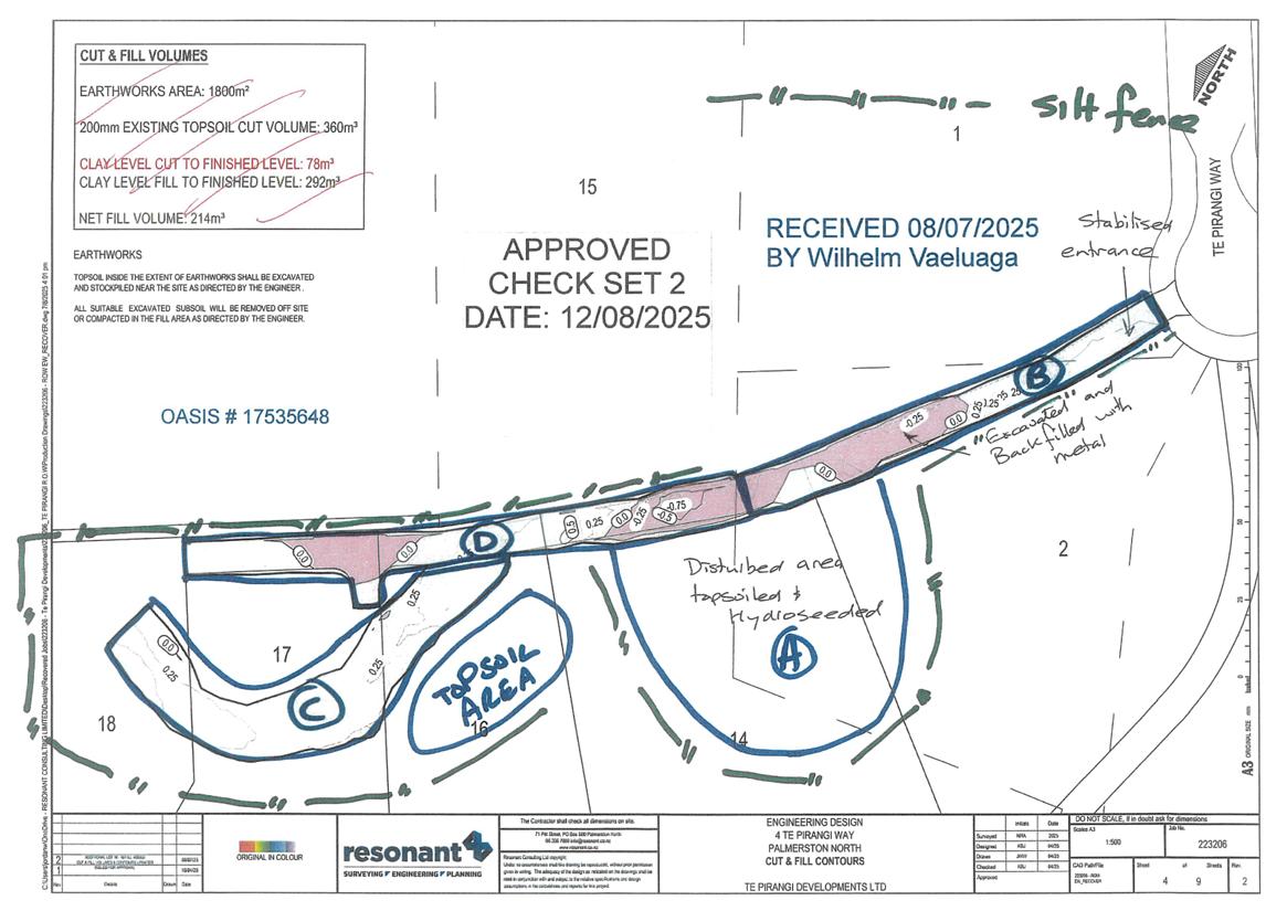
NZTopo50 Centroid BM34:244-243, which is shown in
Site
Plan LOC-2026100059 attached to and forming part of this resource consent.
2.
The Consent Holder must undertake the activity in general accordance with the consent application
including all accompanying plans and documents first lodged with the Manawatū-Whanganui
Regional Council on
26 January 2026; and
a.
25 February 2026, via email, an updated Erosion and Sediment Control Plan dated February
2026 and clarification regarding the rule assessment; and
b.
6 March 2026, via email, being an updated Erosion and Sediment Control Plan dated March
2026.
Where there may be inconsistencies between information provided by the Applicant and conditions
of the resource consent, the conditions of the resource consent will apply.
ADVICE NOTE: Any variance from the location, design concepts and parameters, implementation
and/or operation may require a new resource consent or a change of consent conditions pursuant
to section 127 of the Resource Management Act 1991.
Pre-Development Assurance
3.
A copy of this resource consent and the Erosion and Sediment Control Plan (ESCP), as referred to in
Condition 5, must be kept onsite at all times that this resource consent is exercised. These copies
must be produced on request by a Manawatū-Whanganui Regional Council officer.
ADVICE NOTE: A digital copy of this resource consent is acceptable.
4.
The Consent Holder must be responsible for all contracted operations related to the exercise of this
resource consent. They must ensure contractors are made aware of the conditions of this resource
consent, and ensure compliance with those conditions.
5.
The Consent Holder must undertake all works authorised by this resource consent in accordance with
the certified ESCP titled
“Erosion and Sediment Control Plan Te Pirangi Developments Ltd Te Pirangi
Way Palmerston North Rev 3” dated March 2026, prepared by Resonant Consulting Limited, and any
changes certified under
Condition 15.
6.
The Consent Holder must,
at least five (5) prior to commencing any activities authorised by this
resource consent, appoint a representative(s) who must be the Manawatū-Whanganui Regional
Council’s principal contact person(s) in regard to matters relating to this resource consent. The
Page
13 of
19
Consent Holder must inform the Manawatū-Whanganui Regional Council of the representative’s
name and how they can be contacted, prior to this resource consent being exercised. Should that
person(s) change during the term of this resource consent, the Consent Holder must immediately
inform the Manawatū-Whanganui Regional Council and must also give written notice
within one (1)
working day to the Manawatū-Whanganui Region Council of the new representative’s name and
how they can be contacted.
ADVICE NOTE: The Consents Monitoring Team can be contacted on Freephone 0508 800 800 or via
email
at [email address].
7.
The Consent Holder must notify the Manawatū-Whanganui Regional Council’s Consents Monitoring
Team of the commencement and completion of works. Notice must be provided no less than
five (5)
working days prior to the commencement of activities authorised by this resource consent, and
within
twenty four (24) hours of completing works.
ADVICE NOTE: The Consents Monitoring Team can be contacted on Freephone 0508 800 800 or via
email
at [email address].
8.
Prior to exercising this resource consent, the Consent Holder must arrange and conduct a pre-
construction site meeting and invite, with a minimum of
five (5) working days’ notice, the Manawatū-
Whanganui Regional Council Consents Monitoring Team, the contractor, the site representative as
required by
Condition 6, and any other party representing the Consent Holder.
ADVICE NOTE: In the case that any of the invited parties do not attend this meeting, the Consent
Holder will have complied with this condition, provided the invitation requirement is met.
ADVICE NOTE: The Consents Monitoring Team can be contacted on Freephone 0508 800 800 or via
email
at [email address].
9.
Prior to exercising this resource consent, the Consent Holder must provide the Manawatū-
Whanganui Regional Council Consents Monitoring Team with an ‘as-built’ form for the silt fence(s).
ADVICE NOTE: As-built forms for erosion and sediment control structures can be found on the
Horizons
website
https://www.horizons.govt.nz/managing-natural-resources/consents-
monitoring/earthworks.
Environmental Standard
10.
The Consent Holder must ensure any discharge of sediment arising from the exercise of this resource
consent is minimised. In this regard, erosion and sediment control measures established, operated,
and maintained in accordance with the ESCP and the document titled “
Erosion and Sediment Control
Guide for Land Disturbing Activities in the Wellington Region”, dated February 2021.
11.
The Consent Holder must ensure that clean water run-off, including run-off from catchment areas
above the site, is diverted away from land disturbed during the exercise of this consent.
Page
14 of
19
12.
Any discharge of sediment from outlet structures arising from the exercise of this resource consent
must have at least
100 millimetres (100mm) of visual clarity, measured by Secchi disk or clarity tube,
or alternative certified in writing by the Manawatū-Whanganui Regional Council.
13.
The Consent Holder must ensure the exercise of this resource consent (including the operation of
earthmoving machinery, flocculation, pumps, generators and ancillary equipment) prevents
discharges of contaminants that are toxic to aquatic ecosystems (including fuel, oil, and other
contaminants from machinery) from entering surface water.
14.
The Consent Holder must ensure there is no discharge of airborne dust that is objectionable to the
extent that it causes an adverse effect at or beyond the site boundary.
ADVICE NOTE: The Frequency, Intensity, Duration, Offensiveness, and Location of Exposure (FIDOL)
of any discharge to air may be assessed to determine whether the discharge is objectionable.
Definitions of these aspects are provided in Chapter RP-AIR of the One Plan (2024) Regional Plan, or
any superseding Regional Plan.
Operational Restrictions
15.
Any changes proposed to the ESCP referenced in
Condition 5 must be confirmed in writing by the
Consent Holder and certified in writing by the Manawatū-Whanganui Regional Council’s Consents
Monitoring Team acting in a technical certification capacity, prior to implementing any changes. The
ESCP must be updated
within one (1) working day of any amendments being certified.
16.
When exercising this resource consent, the Consent Holder must at all times comply with the erosion
and sediment control methodologies outlined in the ESCP, and subsequent amendments certified
under
Condition 15.
17.
For all trenching works or underground service installations, any open trench or otherwise disturbed
area must be stabilised prior to any rainfall.
18.
In the event of an archaeological site, waahi tapu or koiwi being discovered or disturbed during the
exercise of this resource consent, the Consent Holder must immediately cease further work and
inform:
a.
The local Iwi and Hapū,
b.
Heritage NZ National Office;
c.
The Police; and
d.
The Manawatū-Whanganui Regional Council’s Consents Monitoring Team.
Further work at the site must be suspended while iwi carry out their procedures for removal of
taonga. The Manawatū-Whanganui Regional Council’s Consent Monitoring Team will advise the
Consent Holder when work at the site may recommence.
Page
15 of
19
ADVICE NOTE: In the event that human remains (koiwi) are found the Police should be contacted
immediately and all works must cease until advice is given that works can recommence.
ADVICE NOTE: Heritage NZ, National Office, can be contacted on (04) 472 4341.
ADVICE NOTE: Manawatū-Whanganui Regional Council’s Consent Monitoring Team can be contacted
on 0508 800 800.
19.
The Consent Holder must stabilise the site by
30 June 2026 in accordance with the ESCP and the
measures detailed in the document titled “
Erosion and Sediment Control Guide for Land Disturbing
Activities in the Wellington Region” dated February 2021, otherwise certified in writing by the
Manawatū-Whanganui Regional Council.
ADVICE NOTE: Stabilisation, under the “
Erosion and Sediment Control Guide for Land Disturbing
Activities in the Wellington Region”, dated February 2021, means inherently resistant to erosion, or
rendered resistant to erosion through the application of proven stabilisation methods (mulching,
grass seeding with top soil, hydroseeding, turfing, geo-textiles, and erosion control blankets)
specified in Section E3 of these guidelines. For seeding, grassing, or hydroseeding, a surface is
considered stabilised once a minimum of 80% vegetative cover has been established over the entire
surface.
20.
The Consent Holder must stabilise the site by
30 April of any year that this resource consent is
current, excluding 2026 as per
Condition 19, in accordance with the ESCP and the measures detailed
in the document titled “
Erosion and Sediment Control Guide for Land Disturbing Activities in the
Wellington Region” dated February 2021, otherwise certified in writing by the Manawatū-Whanganui
Regional Council.
21.
Excluding necessary stabilisation works, land disturbance and cleanfill discharges must not occur
during the winter period
1 July to 30 September 2026, and
1 May to 30 September (inclusive) for
any year that this resource consent is current, unless otherwise certified in writing by the Manawatū-
Whanganui Regional Council.
22.
Requests to undertake earthworks during the period
1 July to 30 September 2026 must be submitted
to the Manawatū-Whanganui Regional Council Consents Monitoring Team prior to 1 June, unless
otherwise agreed to in writing. These requests must be in the form of amendments to the ESCP under
Condition 15.
23.
Requests to undertake earthworks during the period
1 May to 30 September (inclusive) for any year
that this resource consent is current must be submitted to the Manawatū-Whanganui Regional
Council Consents Monitoring Team prior to
1 April, unless otherwise agreed to in writing. These
requests must be in the form of amendments to the ESCP under
Condition 15.
24.
If required by the Manawatū-Whanganui Regional Council’s Consents Monitoring Team, the Consent
Holder must carry out immediate sealing of any problematic dust generating surface within the site
using hydro-seed/hydro-mulch, polymer soil stabilisers or a similar dust control product to provide
instant remediation of dust effects to the satisfaction of the Manawatū-Whanganui Regional
Council’s Consents Monitoring Team.
Page
16 of
19
25.
The Consent Holder must ensure that an adequate supply of water for dust control and an effective
means for applying that quantity of water is available at all times this resource consent is in
operation, and until such a time as the site is fully established, unless otherwise agreed to in writing
by the Manawatū-Whanganui Regional Council Consents Monitoring Team.
Post-Development Assurance
26.
The Consent Holder must consult and obtain written approval from the Manawatū-Whanganui
Regional Council’s Consents Monitoring Team before decommissioning erosion and sediment control
structures. In this respect, the main issues that will be considered by the Manawatū-Whanganui
Regional Council include:
a.
The adequacy of the soil stabilisation and/or covering vegetation;
b.
The quality of the water discharged from the rehabilitated land; and
c.
The quality of the receiving water.
27.
The Consent Holder must stabilise the site as soon as practicable and
within fourteen (14) days of
the completion of land disturbance in accordance with ESCP and the document titled “
Erosion and
Sediment Control Guide for Land Disturbing Activities in the Wellington Region” dated February 2021.
The stabilisation must be undertaken by providing adequate measures (vegetative and/or structural)
that will minimise sediment runoff and erosion to the satisfaction of the Manawatū-Whanganui
Regional Council acting in a technical certification capacity. The Consent Holder must monitor and
maintain the site until vegetation is established to such an extent that it prevents erosion and
sediment from entering any water body.
Monitoring Provisions
28.
The Consent Holder must inspect all erosion and sediment control structures on a
weekly basis and
within twenty-four (24) hours of a rainfall event that is likely to generate runoff from the site or
impair the function or performance of the controls.
29.
The Consent Holder must record the dates, times, and results of the inspections (including what
maintenance was required, on which erosion and sediment control, and when the maintenance was
completed) undertaken under
Condition 28. These records must be provided to the Manawatū-
Whanganui Regional Council
within three (3) working days of a written request to do so.
30.
The Councils must be notified of any complaint received that relates to the exercise of this resource
consent as soon as reasonably practicable and no longer than
two (2) working days after receiving
the complaint.
Page
17 of
19
31.
The Consent Holder must respond to any complaint as soon as reasonably practicable and
within five
(5) working days by advising the Councils and complainant of the outcome of the Consent Holder’s
investigation and all measures taken, or proposed to be taken, to respond to the complaint.
Consent Duration
32.
The resource consent will expire on
27 March 2031.
Page
18 of
19
 Site Plan LOC-2026100059
