

2026 Matuku Link - BRIEFING SHEET - UNMANNED AIRCRAFT OPERATOR MANUAL
BRIEFING SHEET DRAFT COPY 2026
Client Brief Job#
Willows
Client Name:
Matuku Link
or type new:
in representation of Bethells Wetland
Te whakahaere ana i ngā rohe kōreporepo māori ki uta
The Client has undertaken the following conditions with Phylogeny on
01/12/2024
Adjoining Landowners:
YES
YES
Are any adjoining
Have they been
Land owners
NO
notified?
affected?
NO
Land owner
Client
Matuku Link
Notified by who?
Pilot
How have they
In person
Via Email
been notified?
Via Telephone
Mailbox drop
Community meeting, emails, phone calls and personal visits
Names and Issues of affected neighbours:
Bethells Wetland Community see file for list of parties and permissions granted attached.
Name:
Issue:
LAND OWNER OCCUPIER BRIEFING
YES
Danger to Neighbours?
NO
Any drift issues on target property, sensitive vegetation, stock, beehives or
YES
waterways to be aware of?
NO
YES
Other hazardous operations?
NO
Details:
Military operational airspace. Low level flying, unannounced flights occuring.
Drone spraying has risks of: Spray drift to non target area, drone could lose contact and fly away, drone could
crash. Drone could contact wildlife birds. expected to be in the vicinity.
Birds, reptiles,frogs and invertebrates will be in the area, some close proximity of the drone and some contact of
spray will be possible.
Wasps, large amounts of wasps are noted and human contact will be possible.
Possible human incursion into the spray zone.
A Safety Risk Assessment Form is attached for details of mitigation.
UAOM Job Sheet - MATUKU LINK
Page 1
2026 Matuku Link - BRIEFING SHEET - UNMANNED AIRCRAFT OPERATOR MANUAL
ANY OVERHEAD WIRES?
YES
NO
THEIR LOCATION:
TBA
Sensitive Areas
Sensitive Areas – Mark on map below
Factors to consider before spraying and Measures
(description and location of neighbouring crops /schools /
to be used to avoid contamination of sensitive
houses / roads – especially those used by children such as
areas.
school bus routes)
(eg: low drift/Controlled Droplet Application nozzles,
no-spray buffer zones, favourable wind direction,
school holidays)
Activity and process
Controls
1/ To, Drone spray where safe to do so for the control of the 1/a: Spray will
not be applied Onto or Into Water in
invasive Crack Willow ( Salix x fragilis) to protect the
accordance with the HSNO act 1996. Spray will be
wetland of Bethells Matuku Link as per attached maps,
applied to the willow foliage and spraying will cease
secondary information attached.
over water.
/b: All flight activity will be in accordance with the
Civil Aviation Act 1990.
/c: All activities will be in accordance with the
NZS
8409: 2021 Management of Agrichemicals.
/d: Application in accordance with Council
requirements.
/e: Application in accordance with EPA active
component list of acceptable herbicides that can be
applied over water when under control of a qualified
person.
2/ Drone spraying of Glyphosate over crack willow in the
2/a: Certificate of compliance under section 139 of
wetlands for control of population. Factors
the RMA 1991 has been issued for the activity.
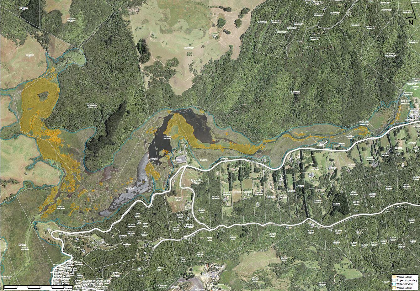
for application: Extent of wetland described as 129-175 Bethells
Road Waitakere as shown on aerial attached.
Drone application is accurate, low level and follows previous /b: Phylogeny’s Chief Pilot is Part 102 Certified.
detailed mapping of the willow population, extent and
Phylogeny’s Chief Pilot Has current Pilots Chemical
instance of willow, other areas of non willow, namely
rating, and is a qualified person to apply herbicides
partially or wholly obscured native pockets and vestiges of
over or near waterways.
indigenous flora. Very little drift will occur due to
management procedures.
Bird counts and nest will be checked to ensure all fledgling /c: Herbicide selection ensure labels are in
has finished and resident populations are able to move
accordance with activity, see below.
away from the drone spraying.
Dilution rates are per Label recommendations, at no
time will concentrate chemical be over, in or
immediately beside waterways.
UAOM Job Sheet - MATUKU LINK
Page 2
2026 Matuku Link - BRIEFING SHEET - UNMANNED AIRCRAFT OPERATOR MANUAL
/d: Small batches of herbicide will be mixed in
separate tank to reduce any left over chemical and
for small volume >200L amounts for safety. Seasonal
application is chosen to be applied from December
to April when the wetland water level is at its
lowest, therefore reducing water exposure from any
potential drift.
/e: Equipment is fully certified and has current
compliance certificates and complies with all
CAA
regulations and rules.
/f: Wind will be measured by an Anemometer during
all spraying activities. Data is recorded via an app
and included in Daily Spray Diary. Anemometer is set
up at LZ before spraying commences and a reading is
taken approx. hourly. In accordance with Pilots CAA
certification. DJI Agras T50 has maximum
operational wind speed 21.6 km/h
/g: CDA nozzles (Controlled Droplet Application.
ultra-low volume spray, drastically reduce drift,
water usage & chemical runoff) , or a droplet that is
Medium 32 drops per cm to Coarse 35 drops per cm.
or 200 - 300Mu.with maximum drift of 1 m with air
velocity of 5kph. and height at application of
between 1m to 3m.
Aquakynde after discussion with EPA and Auckland City
/h: Addition of adjuvant Aquakynde will both assist
Council representative.
D-Glucopyranose, oligomeric, decyl with target accuracy through droplet coagulation,
octyl glycosides (CAS 68515-73-1) (Aquakynde) is a non-
droplet spread and reduced surface tension in
ionic Wetter Spreader surfactant to enhance spreading and addition to positive charge molecular difference,
retention of pesticide sprays. For use in situations where
Droplets will spread and dry quickly and become
low aquatic toxicity is required. Made from naturally
rainfast within 30 minutes.
derived raw materials. Avoid contaminating waterways with
concentrate and empty containers. At typical use
concentrations, toxic dose effects will be low and will drop
below toxic threshold. Product is readily biodegradable.
(ref: NZ NOVACHEM AGRICHEMCAL MANUAL)
/i: Drone nozzles can be turned off or paused to
accurately apply herbicide to
target areas.
/j: Landing Zones are on private land, will be marked
on map and will be GPS positioned for accurate
position and identification if anything were to go
wrong ie: spills "Warning Spraying in Progress"
signs are placed during set up of LZ.
At Vehicle and ANY Access point to the spray site.
Orange Road cones & Retractable belt barrier / tape
to stop any unauthorised person entering into LZ.
Spotter to confirm no unauthorised people accessing
area: if they do spraying must STOP
All signage is removed AFTER the spray day has been
completed.
UAOM Job Sheet - MATUKU LINK
Page 3
2026 Matuku Link - BRIEFING SHEET - UNMANNED AIRCRAFT OPERATOR MANUAL
/k: A Spill tray will be used to both protect the
ground from contamination and to collect any minor
drips that may occur when re supplying the drone
with herbicide.
/l: Bunding system is on board as is a spill kit in case
of emergency. LZ are selected to ensure that if a spill
did occur the chemical can be intercepted before
entering a waterway.
/m: Spotter persons will be positioned around the
spray site to ensure and confirm spray accuracy,
spray delivery to target, to ensure no unauthorised
persons can enter the application zone, and to be
recovery persons if in the unlikely case the drone
has failure and lands.
3/ Craft possible contact with water/ emergency landing.
3/a: A floating pontoon has been provided to assist
with viewpoints for a spotter and also to be an
emergency landing platform for the drone.
/b: The drone has built in redundancy to allow for
emergency landing if a motor should fail.
/c: Flotation devices have been affixed to the drone
should an emergency landing be required in water,
the unit is completely contained and will not spill
contents unless a catastrophic accident were to
occur.
/d: With strict maintenance regime and annual
certification process this possibility has been
reduced to an almost negligible level. However
recovery and reduction of harm strategy is in place
to retrieve with kayaks asap.
4/ Communication
4/a: Starlink will provide real time mapping services,
mobile phone VOIP service, comms to outside
people.
/b: Radio Telephones will be issued to all key staff to
maintain comms and feedback on progress and
confirmation of position, also onsite minor weather
variances.
5/ Signal strength (Dual band ensures strong coverage)
5/a: A Relay system will be used to maintain a high
signal strength to the drone and navigation systems.
RTK (real time kinematic) a GPS correction method
that uses a base station to provide real time
corrections to a moving receiver.
6/ Other drones intruding into NOTAM area, possible
6/a: Spotters will maintain constant visual scan for
malicious intent.
other UAS or manned flights, protocols will be
followed.
In case of malicious disruption all craft will land,
Police and CAA notified.
UAOM Job Sheet - MATUKU LINK
Page 4

2026 Matuku Link - BRIEFING SHEET - UNMANNED AIRCRAFT OPERATOR MANUAL
Chemical
PHYLOGENY
Who is supplying the chemical to be used?
CLIENT
You confirm that you understand and are
Please note if we use Client chemical and seals are broken responsible for withholding periods and
or it has expired or is incorrectly labelled, Phylogeny has
understand the toxic nature to stock and sprayed
no liability in regards to these things.
plants.
CHEMICAL
APPLICATION RATE PER HECTARE
Polaris 450 Glyphosate
9 - 12 Litres per Ha.
AntiFoam 1410
20ml/100L
Blue FIL done that marker dye.
300ml/100L
Aquakynde
.6L/100L
Water rate per hectare
150/200L per
100 L per ha. up to 230 L / ha.
Diluted suitable rate for application.
Have Target Area(s) been identified?
YES
Describe target(s) and their proximity etc:
Willow trees as per aerial plans, supplied by Phylogeny and modified by Auckland City Council with consented
activity.
Land Owner and Pilot completed a recce of the target area on :
Land Owner and Pilot completed an assessment of the target area on multiple and on going occasions.
I, Matuku Link, as Kaitiaki of Bethells Wetland representing multiple landowner / occupier or their legal agent. I
certify that the above is correct and that I am satisfied that I have detailed all extraordinary hazards and other
details as specified above to Phylogeny. I give permission for Phylogeny and its personnel to have access and work
on the property.
Designation
Owner:
Signature:
Date:
UAOM Job Sheet - MATUKU LINK
Page 5
2026 Matuku Link - BRIEFING SHEET - UNMANNED AIRCRAFT OPERATOR MANUAL
MAP OF TARGET AREA
UAOM Job Sheet - MATUKU LINK
Page 6