


Item 01
Crown Pastoral Land
Tenure Review
Lease name :
EARNSLAW
Lease number : PO 047
Conservation Resources Report
As part of the process of Tenure Review, advice on significant inherent
values within the pastoral lease is provided by Department of
Conservation officials in the form of a Conservation Resources Report.
This report is the result of outdoor survey and inspection. It is a key
piece of information for the development of a preliminary consultation
document.
The report attached is released under the Official Information Act 1982.
Released under the Offical Information Act
May 12
RELEASED UNDER THE OFFICIAL INFORMATION ACT
DOC CONSERVATION RESOURCES
REPORT ON TENURE REVIEW OF
EARNSLAW PASTORAL LEASE
Released under the Offical Information Act
link to page 7 link to page 9 link to page 9 link to page 9 link to page 16 link to page 17 link to page 17 link to page 19 link to page 19 link to page 26 link to page 36 link to page 38 link to page 42 link to page 42 link to page 44 link to page 45 link to page 46 link to page 47 link to page 47 link to page 49 link to page 49 link to page 50 link to page 52 link to page 52
RELEASED UNDER THE OFFICIAL INFORMATION ACT
PART 1: INTRODUCTION ..............................................................................3
PART 2: INHERENT VALUES: DESCRIPTION OF CONSERVATION
RESOURCES AND ASSESSMENT OF SIGNIFICANCE ...............................5
2.1
Landscape.................................................................................................................................... 5
2.2
Landforms, Geology & soils..................................................................................................... 12
2.3
Land Environments of New zealand.......................................................................................13
2.4
Climate ...................................................................................................................................... 15
2.5
Vegetation.................................................................................................................................. 15
2.6
Fauna ......................................................................................................................................... 22
2.7
Historic ...................................................................................................................................... 32
2.8
Public Recreation...................................................................................................................... 34
PART 3: OTHER RELEVANT MATTERS & PLANS ....................................38
3.1
Consultation .............................................................................................................................. 38
3.2
Regional Policy Statements & Plans ....................................................................................... 40
3.3
District Plans ............................................................................................................................. 41
3.4
Conservation Management Strategies & Plans...................................................................... 42
3.5
Freshwater Fisheries Plans ...................................................................................................... 43
3.6
Ngai Tahu Claims Settlement 1998, No. 97 ............................................................................ 43
3.7
New Zealand Biodiversity Strategy......................................................................................... 45
3.8
Protecting Our Places............................................................................................................... 45
3.9
Ecological Sustainability and Carbon Storage....................................................................... 46
Released under the Offical Information Act
PART 4: MAPS ETC. ....................................................................................48
4.1
Additional information............................................................................................................. 48
RELEASED UNDER THE OFFICIAL INFORMATION ACT
PART 1: INTRODUCTION
1.1
The lessees of Earnslaw pastoral lease (PL) have reapplied to the Commissioner of
Crown Lands (CCL) for a review of the property’s pastoral lease tenure. The property
originally entered the tenure review programme in 2002 but was withdrawn by LINZ
in 2004.
The PL was originally inspected by DOC specialists for tenure review purposes
between 11-15th February 2002. In December 2010, two days were spent on the
property to assist with the updating of the conservation resources report. Information
attained during the recent inspection has been incorporated into this revised report.
Significance of the values has been assessed against revised DOC guidelines.
Earnslaw Station is leased by Geoffrey Lewis Thomson. The 5253 hectare property is
located at the head of Lake Wakatipu, approximately 18 kilometres from Glenorchy.
The property lies immediately south of Mt Earnslaw/Pikirakatahi (2830 m.a.s.l). It is
bound by the Rees River to the east, and the Dart River to the west.
When the Thomson family first leased Earnslaw Station in 1952, it comprised 14900
ha, and included Mt Earnslaw/Pikirakatahi and some of the Forbes Mountains. A
Special Condition was included in the lease whereby the lessee agreed that “... the
lessor shall resume any portion or portions of the land included in the lease for the
purpose of the creation of a National Park, the Lessee shall not be entitled to any
compensation or reduction in rental for any loss of grazing or other inconvenience
arising from such resumption, but not including any loss of substantial
improvements”.
In 1971, 364 ha of beech forest in the Dart valley were resumed and added to Mt
Aspiring National Park, followed in 1973 by 9250 ha, which saw Mt. Earnslaw and
the southern Forbes Mountains become part of the National Park.
The significance of Ngai Tahu’s traditional association to Mt Earnslaw/ Pikirakatahi
is specifically acknowledged in the Ngai Tahu Claims Settlement 1998.
Released under the Offical Information Act
Today, the PL is divided into two geographically separated blocks. The first is the Mt
Alfred area, which includes approximately 1300 ha, extending from valley floor (380
m) to the summit of Mt Alfred (1375m). It adjoins the Diamond Creek flats and the
Dart River. The second area near Mt Earnslaw/Pikirakatahi covers approximately
3900ha. It includes the western side of Rees River, from near Lennox Falls
downstream to Lovers Leap and Cockburns Bush, and the Earnslaw Burn catchment
(excluding the forested Lower Dart Conservation Area). This area extends from valley
floor (380m) to mountaintops, and includes Turret Head (2315m), Black Peak
(2240m) and Lennox Pass (1697m). The northern boundary of this part of the PL
skirts along the base of the Earnslaw Glacier.
RELEASED UNDER THE OFFICIAL INFORMATION ACT
The homestead is situated off the Glenorchy-Paradise Road between the two parcels
which make up the PL, on adjoining freehold land.
The PL lies mainly within the Aspiring Ecological Region and Dart Ecological
District. The eastern side of the property is in the Lakes Ecological Region and
Richardson Ecological District. No Protected Natural Areas Survey Programme
(PNAP) of these districts has been carried out.
No parts of the lease are currently subject to formal protection; however, the property
is surrounded by land protected for conservation purposes: -
• Mt Aspiring National Park to the north
• Lower Dart Conservation Area (ex State Forest Earnslaw Burn)
• Mt Alfred Conservation Area (ex State Forest at northern and southern end of Mt
Alfred)
• Diamond Lake Wildlife Management Reserve
• Diamond Lake Recreation Reserve, eastern side of Mt Alfred above Diamond
Lake
• Recreation Reserve (southern end of Mt Alfred, between State Forest and
Glenorchy-Routeburn Road)
Released under the Offical Information Act
RELEASED UNDER THE OFFICIAL INFORMATION ACT
PART 2: INHERENT VALUES: DESCRIPTION OF CONSERVATION
RESOURCES AND ASSESSMENT OF SIGNIFICANCE
2.1 LANDSCAPE
Methodology
Earnslaw Station is broken into four landscape units (refer Map 4.2.2). These include:
•
Mt Alfred (LU1)
•
Valley Floor (LU2)
•
Earnslaw Burn (LU3)
•
Rees Valley (LU4)
For each unit a landscape character description is provided along with a description of
the key visual and scenic attributes present. An evaluation summary has been
undertaken for each unit using a range of criteria to determine inherent values present.
The criteria include:
1.
Intactness: - refers to the condition of the natural vegetation, patterns and
processes and the degree of modification present.
2.
Legibility: - refers to its expressiveness - how obviously the landscape
demonstrates the formative processes leading to it.
3.
Aesthetic Factors: - include criteria such as
distinctiveness - the quality that
makes a particular landscape visually striking. Frequently this occurs when
contrasting natural elements combine to form a distinctive and memorable visual
pattern. A further criteria assessed under aesthetic factors is
coherence. This is based
on characteristics including intactness, unity, continuity, and compatibility.
Intrusions, alterations, disruptions tend to detract from coherence.
4.
Historic Factors: - refers to historically valued attributes in the context of a high
country landscape.
5.
Visibility: - refers to the visibility from public places such as highways,
Released under the Offical Information Act
waterways or local vantage points.
6.
Significance: - is the significance of the characteristics and features, or
combination of characteristics and features within individual units and whether they
are locally, regionally or nationally significant.
7.
Vulnerability: - is a measure of each landscape unit’s susceptibility to further
ecological deterioration, which would impact on landscape values.
RELEASED UNDER THE OFFICIAL INFORMATION ACT
Landscape Unit 1 (LU1) – Mt Alfred
Character Description
Mt Alfred is a steep to very steep ice-scoured isolated mountain block rising abruptly
within the fluvio-glacial valley floor of the Rees and Dart Rivers. Its glacial origins
are highly legible. The rivers of ice although not over topping Mt Alfred but have
resulted in extensive scraping and scouring of the sides as the ice parted and moved
around its flank.
This ice-sculptured landform has steep rocky slopes and ice-shorn features.
Vegetation is a diverse mix of beech forest (much of it conservation land), snow
tussock, subalpine scrub, modified fescue /snow tussock grassland, shrubland,
bracken and matagouri.
The east side is a patchwork of beech forest, bracken and regenerating shrubland and
tussock. Tussock includes both fescue and tall tussock with a significant indigenous
inter-tussock component. Exotic grasses and legumes are also part of the mix.
Tussock is dominant above the bushline, and appears robust and in good condition.
Farm access tracks cut across the bracken covered open slopes above Diamond Lake
and Lake Reid are assuming less dominance as bracken and regenerating shrubland
slowly mask their visual impact. A large natural slump occurs above Diamond Lake.
A small fan with scattered matagouri, exotic grasses and thistle has formed at the
southern end of Diamond Lake.
The Dart side (west) of Mt Alfred retains similar characteristics to the east side.
Watercourses cut vertically into ice worn bedrock. A large mid section of the
mountain slope is clothed in bracken with regenerating shrubland and grassy areas
grading into tussock further up. Similar bracken fern country occurs on the northwest
flank but also includes a large chunk of beech forest adjacent to land owned by
Paradise Trust Ltd.
Key Visual & Scenic Values
Mt Alfred is a dominant and important landscape feature between the two rivers at the
‘Head of the Lake’. It is separate from the main ranges and visible over a wide area.
Released under the Offical Information Act
Most views at the Head of the Lake include Mt Alfred, including views from the
Glenorchy Routeburn Road and the Glenorchy Paradise Road. The steep, ice shorn,
rocky and distinctive landform and the patchwork of beech, tussock, shrubland,
bracken and emerging shrubland is a Glenorchy icon and highly memorable in the
context of the Head of the Lake.
Mt Alfred’s eastern face forms the visual backdrop to Diamond Lake, Diamond
Creek, and Lake Reid. This is an area widely recognised as having high scenic values.
For some people the access tracks and the periodic burning of bracken and scrub
detract from visual values. This aside, Mt Alfred has a high level of landscape
RELEASED UNDER THE OFFICIAL INFORMATION ACT
coherence. Natural patterns, though modified are intact. Modified areas can be
returned to a more natural state with different management.
Evaluation Summary
Criteria Value
Comment
Intactness Medium
to
Varies. Beech and tussock intact. Bracken
High
and shrubland more modified
Legibility High
Glacial
processes highly legible
Aesthetic Factors
High
Highly distinctive and visually impressive
glacial landform. Cloak of indigenous
vegetation very distinctive. High level of
landscape coherence
Historic Factors
-
Culturally important to Maori and
European
Visibility
High
Very visible from most areas at the Head
of the Lake. Important local landmark.
Significance High
Vulnerability
Medium
Landscape values vulnerable to scarring by
access tracks and bracken and shrubland
burning
Landscape Unit 2 (LU2) – Valley Floor
Character Description
This unit includes the small areas of fluvio-glacial outwash plains and fans within the
PL (but excluding Rees Valley flats). The unit includes the narrow strip adjacent to
the Dart and Mt Alfred, the small areas adjacent to Diamond Creek and toe slopes
below Lovers Leap.
A narrow strip of valley floor, which is part of the Darts meander floodplain, is
present from the base of Mt Alfred to the edge of the river bed. Vegetation is
primarily pasture grasses in the strip from Humes Road to a prominent point where
Mt Alfred intersects with the river (approximately three kilometres).
The Diamond Creek flats include the small parcels of land adjacent to the Diamond
Released under the Offical Information Act
Creek wetland system at the base of the east side of Mt Alfred. It is a remnant of a
much larger wetland that extended over the valley floor. Diamond Creek meanders
along the floodplain below Mt Alfred within a fenced corridor. Vegetation is a mix of
exotic grasses and native sedge and rush. Matagouri woodland is also a distinctive
feature.
The third area of valley floor is below Lovers Leap. The narrow fan below Lovers
Leap consists of pasture grasses and scattered matagouri, but also includes a
significant stand of red beech. Stock graze into the bush edge. A small pond occupies
low-lying topography within open farmland. Waterfowl are abundant.
RELEASED UNDER THE OFFICIAL INFORMATION ACT
Key Visual & Scenic Values
All three areas described form a small segment of the fluvio-outwash plain. The
outwash plain inturn is part of a larger montane landscape widely recognised as
having outstanding visual and scenic values.
The Dart River strip, while entirely modified in terms of vegetation is part of an
important braided river system with high scenic values.
The Diamond Creek flats contain high visual values derived from the natural
character of the meander floodplain and wetlands, the quality of the water, and its
superb setting at the base of Mt Alfred.
The toe of Lovers Leap is notable for the stand of red beech at the base of the steep
and precipitous scarp behind it which forms part of the view of this landscape feature.
Evaluation Summary
Criteria Value
Comment
Intactness Medium
Vegetation
modified for all three locations
Legibility
High
Natural processes very legible
Aesthetic Factors
High
All locations visually very coherent
Historic Factors
-
Not significant
Visibility High
Reasonably
visible from public places
Significance High
Diamond
Creek
is a very important local
waterway with high water quality
Dart River strip is part of a nationally
significant braided river
Red Beech are a significant local stand at
the Head of the Lake
Vulnerability Medium
to
Diamond Creek wetland vulnerable to
High
landuse changes
Landscape Unit 3 (LU3) – Earnslaw Burn
Character description
Released under the Offical Information Act
This unit includes all of the lease area within the Earnslaw Burn. The Earnslaw Burn
is an impressive alpine valley and integral part of the Mt Earnslaw/Pikirakatahi
massif. It is a classic U-shaped valley, heavily glaciated and upper regions steep to
precipitous. Eroded bedrock, cirque basins, permanent ice and snow, scree and talus
slopes, ice-shorn rock, and moraine are all features of the upper basin. The Gilkison
Falls are within the PL. Alpine vegetation, snow tussock and subalpine scrub,
herbfield and pockets of beech forest are the main vegetation types. A subalpine
basin extends from the bushline at about 900 metres to the head of the valley. The
Earnslaw Burn meanders across the narrow valley floor with extensive boulder fields,
snow tussock, and subalpine scrub. Grazing has introduced an exotic component
RELEASED UNDER THE OFFICIAL INFORMATION ACT
particularly on sites favoured by stock. Natural characteristics are dominant and
intact.
The open tussock-covered mountain slopes on the true left of the Earnslaw Burn
(between Lovers Leap and the Earnslaw Burn bushline) are the most modified area of
the unit. The lower parts are predominantly browntop and scrub, grading into
scattered snow tussock. A slip area is located between the Lovers Leap scarp and the
beech forest.
Key Visual & Scenic Values
This mountainous unit has inherently high visual and scenic values that are
synonymous with Mt Earnslaw/Pikirakatahi and the ranges west of the main divide.
These values are derived from the following features:
Visually impressive, heavily glaciated alpine landscape including ice scraped rock,
talus and scree slopes, cirque basins, waterfalls
A subalpine glaciated basin with intact snow tussock and shrubland
The Earnslaw Burn forms an integral and important part of the landscape of one of
Otago’s tallest and well known mountains
The unit is part of a mountainous area that represents sheer alpine splendour and
grandeur.
Evaluation Summary
Criteria Value
Comment
Intactness
High
Natural characteristics intact apart from
localised areas. In a landscape sense
retains appearance of a natural landscape
Legibility
High
Underlying landform processes very
legible
Aesthetic Factors
High
Very distinctive and memorable. High
degree of landscape coherence
Historic Factors
-
Visibility
Low
Most of basin out of public view
Significance High
Significant
in the context of Mt
Earnslaw/Pikirakatahi and Mt Aspiring
Released under the Offical Information Act
National Park
Vulnerability
High
Fragile alpine area
Landscape Unit 4 (LU4) - Rees Valley
Character description
This unit is typical of high rainfall, western mountain/glaciated valleys east of the
main divide, with predominantly beech covered valley sides, grassy valley floor and
braided river.
RELEASED UNDER THE OFFICIAL INFORMATION ACT
The upper mountain area of the unit has similar characteristics to LU3 (Earnslaw
Burn) with the same very rugged ice plucked landform and steep to precipitous
slopes. However the lower slopes and valley floor have different characteristics and
justifies a separate unit. The unit includes the whole of the east faces of the Rees
Valley (within Earnslaw Station) from the Lovers Leap ridge to the northern end of
the lease and including the valley floor.
The east facing mountain slopes are very steep, heavily glaciated with much bare
rock, gnarled landforms, high basins and predominantly snow tussock and sub alpine
scrub. Deeply incised slot gorges cut into bedrock and waterfalls are significant
features. Beech forest is extensive and dominant on lower colluvial side slopes below
approximately 1200 metres but extends higher within dark gorges and watercourses.
Some pockets of red beech occur away from the bush edge.
Generally the faces at the southern end of the Rees Valley are more modified by
grazing and burning than further up the valley. Lower slopes in between large areas
of bush have been converted to bracken and grass for grazing. These areas also
include matagouri with shrubland associated with bluffs and more rugged areas.
North of Cockburns Bush is also modified. A stock track through the bush provides
access to open tussock, bracken and introduced grasses above the bushline. These
pockets of modified areas are relatively small and natural character remains dominant.
The Lovers Leap scarp is sheer and bush clad apart from a small cleared toe slope of
bracken fern and grass.
The Rees Valley flats (Top Flats, Middle Flats, and Bottom Flats) are similar to each
other in character. The wide braided and active Rees River meanders across the
valley floor. The scale of the main valley is large. Terraces, fans, dry watercourses
and backswamps are typical characteristics of the flats. The grass covered valley floor
consists of introduced grasses and a substantial native component of short tussock and
other low native species.
In 2002 the lessees were granted consent by the CCL to cultivate an area of flats at the
northern extremity of the PL in the Rees Valley. This area in part adjoins Mt Aspiring
National Park. This work has been undertaken. While the flats still retain their open
landscape characteristics, their degree of naturalness has been degraded. In addition to
the area consented for within the PL, an area comprising Crown land river bed and
marginal strip have also been cultivated.
Taken together, the rugged upper slopes, bush covered valley sides, and valley floor
reads as a highly natural landscape.
Released under the Offical Information Act
Key Visual and Scenic Values
This unit (as with much of the PL) has inherently high visual values derived from the:
• Steep, rugged heavily glaciated mountain slopes from one end of the unit to
the other.
• Pattern of vegetation i.e. grass covered valley floor contrasting with beech
forest, shrubland, tussock and sub-alpine scrub.
• Impressive water forms i.e. waterfalls, gorges and the braided Rees River and
associated watercourses and wetlands.
RELEASED UNDER THE OFFICIAL INFORMATION ACT
• Scale and grandeur of the valley as a whole and impressive views up and
down valley.
Evaluation Summary
Criteria Value
Comment
Intactness Moderate-
Mostly high. Localised areas on lower
High
mountain slopes and valley floor modified
(in particular the recently cultivated upper
Rees Flats). Natural patterns and
processes largely intact.
Legibility
High
Formative processes highly legible
Aesthetic Factors
Moderate -
Visually coherent. Few disruptive
High
features. Visually impressive
Historic Factors
Not significant
Visibility Low
to
Viewed from Rees and Dart Walking track
medium
Significance High
Important
backcountry valley on the edge
of Mt Aspiring National Park
Vulnerability
High
Vulnerable to farm development e.g.
cultivation, fencing, structures drainage on
valley floor. Burning on valley sides
2.1.2 Significance of Landscape Values
Earnslaw Station has inherently high landscape values (see Map 4.2.2). The PL is on
the edge of Mt Aspiring National Park within an area recognized as having
outstanding landscape values. Much of it is mountainous with spectacular glacial
features and largely intact and highly natural vegetation patterns.
Mt Alfred is a major local landmark and, an outstanding example of an ice scoured
isolated mountain block within a fluvio-glacial valley floor. It retains highly natural
and distinctive vegetation patterns of beech, tussock, and shrublands. It also is an
important landscape feature forming the backdrop for many dramatic views at the
Head of the Lake, including the Diamond Lake/Paradise area and the lower Dart
River.
Released under the Offical Information Act
The Earnslaw Burn is a spectacular alpine valley and part of the Mt
Earnslaw/Pikirakatahi massif. The upper Earnslaw Burn represents an area of alpine
splendour and very high landscape values. The lower slopes from the bush line to the
east ridge are more modified but still appear as a tussock grassland and integral to Mt
Earnslaw/Pikirakatahi as an entity.
The small parcels of land adjacent to Diamond Creek provide a protective buffer and
context for this important waterway.
RELEASED UNDER THE OFFICIAL INFORMATION ACT
The red beech below Lovers Leap is a significant stand in a landscape sense, and
contributes to the special natural quality and integrity of this high country landscape.
Its long-term viability is being threatened by grazing.
The Dart River strip is significant as part of the Dart River floodplain.
The Rees Valley Unit as a whole contains very high landscape values derived from
the steep, rugged and glaciated mountain slopes and fluvial/glacial floor, the contrast
and diversity of vegetation patterns, (beech, shrubland, tussock and sub alpine scrub
and valley floor plant associations). It appears as a predominantly natural and
indigenous landscape with similar and complementary values to the adjoining Mount
Aspiring National Park.
2.2 LANDFORMS, GEOLOGY & SOILS
Landforms and Geology
The underlying geology of the PL is predominantly schist and schist/greywacke
intergrades. The geomorphology of the lower slopes is heavily influenced by past
glacial activity, characterized by glacial till and schist gravels of fluvio-glacial origin.
The river flats comprise greywacke/schist gravels and loess.
The lower Dart and Rees Valleys as they emerge from the mountains were filled by
vast quantities of glacial moraine created by the coalescing of several valley glaciers.
Reworking of glacial moraine gravels by the rivers has formed an extensive area of
flat land from below Sandy Bluff on the Dart and below the Twenty-Five Mile Creek
on the Rees. Small areas of river flats along the lower Rees River, base of Lover’s
Leap, and base of Mt Alfred are included in the PL.
Landforms on the up valley side of glacial flow tend to be smooth and rounded from
abrasion whilst cliff features on the downside of the ice flow such as Lovers Leap,
were formed by a plucking action. Mt Alfred located between the Rees and Dart
Rivers is an example of a dome-shaped roche moutonnee.
The alpine parts of the property exhibit more recent signs of glaciation. The lower part
of Earnslaw Glacier is located within the property in the upper valley of the Earnslaw
Released under the Offical Information Act
Burn, while surrounding vertical to overhanging faces are swept by ice and snow
avalanches.
Soils
The river flats are characterised by Matukituki sand loams, silt loams and stony
loams, of medium natural nutrient status. The montane hillslopes are characterised by
Moonlight Steepland sand loams while subalpine hillslopes have McKerrow
Steepland sandy loams, both of which are of very low natural nutrient status. Cass
soils also occupy hillslopes of low to very low natural fertility. The alpine zone which
mostly features bare ground, comprises Alpine Steepland soils.
RELEASED UNDER THE OFFICIAL INFORMATION ACT
2.2.1 Significance of Landform, Geology and Soils
The lower Earnslaw glacier lies within the PL, together with a range of other
landforms resulting from glaciation. These include alpine cirque basin, U shaped
valley, roche moutonnee (Mt Alfred), and braided riverbeds. These landforms are
rarely found together within pastoral leases, and are all highly significant.
2.3
LAND ENVIRONMENTS NEW ZEALAND
There are two databases that have been used to assess biodiversity protection (Walker
et al. 2003).
1.
Environmental distinctiveness has been assessed through the Land
Environments of New Zealand (LENZ). This is a classification of New
Zealand landscapes using a comprehensive set of climate, landform and soil
variables chosen for their roles in driving geographic variation in biological
patterns (Leathwick
et al. 2002 & 2003). It is presented at four levels of detail
containing 20, 100, 200 or 500 environments nationally. The most detailed is
called LENZ Level IV.
2.
The area of unprotected indigenous cover in threatened land environments has
been identified in the national land cover database (LCDB).
From the above databases, spatial data depicting indigenous cover and legal protection
were overlaid on LENZ Level IV environments to identify biodiversity that is most
vulnerable (most likely to be lost). This provides a measure for:
a.
percentages legally protected and;
b.
percentages
of
remaining indigenous cover
Based on these two criteria, five categories of threatened environments have been used
to identify environments containing indigenous biodiversity at most risk of loss. They
are classified as follows:
1.
Acutely threatened: <10% indigenous cover remaining
Released under the Offical Information Act
2.
Chronically threatened: 10-20% indigenous cover remaining
3.
At risk: 20-30% indigenous cover remaining
4.
Critically underprotected: >30% indigenous cover remaining and
<10% protected
5
Underprotected: >30% indigenous cover remaining and 10-20%
protected
6.
No Threat: >30% indigenous cover remaining and >20% protected
RELEASED UNDER THE OFFICIAL INFORMATION ACT
Table 1:
Land Environments of New Zealand (LENZ) Units on Earnslaw
PL
Threat Category
Level 4 %
%Protected
Indigenous Approximate
LENZ
Indigenous nationally for
Vegetation Area on Lease
Unit
vegetation conservation
Cover
(ha)
cover
purposes
Change
remaining
1997-2002
At Risk
M2.2b 22
13
No change 185
Q4.3a 23
8
Decrease 12
Critically
Q2.1a 38
9
Decrease 9
Underprotected
Underprotected
Q3.3c 90
17
No
.2
Change
Q4.1c 52
20
Decrease 125
Q1.1c 91
18
No
change 640
No Threat
M2.3a 62
70
No
change 124
Category
O1.4a 67
54
Decrease 5
O2.3b 100
98
No
change 210
P5.1d 97
92
Decrease 309
P5.1e 86
34
No
change 43
P5.2a 73
54
Decrease 4
Q1.1a 98
25
No
change 3
Q1.1d 85
35
No
change 37
Q1.2a 99
37
No
change 1482
Q4.2a 34
25
Decrease 3
R1.1a 99
76
No
change 52
R1.1b 100
60
No
change 1183
R1.1e 100
99
Decrease 335
R1.2b 100
99
Decrease 475
T1.1a
100
97
No change 17
Total
5253
2.3.1 Significance of Land Environments of New Zealand
Released under the Offical Information Act
Attributing significance to LENZ units, while a useful exercise must be treated with
caution. Work is currently underway to improve the accuracy of underlying spatial
data. For example, soils data is being upgraded, as median patch size for polygons
sourced from the Land Resource Inventory is currently between 10,000 and 100,000
hectares, while at Level IV resolution, LENZ units cover areas as small as 10
hectares. Also underway, albeit as lesser priority, is ongoing work relating to
continuous improvements of the underlying classification process which generates
LENZ units.
Earnslaw PL has a tiny area comprising less than one percent of the PL area made up
of land environments that are significant because the indigenous vegetation cover has
RELEASED UNDER THE OFFICIAL INFORMATION ACT
largely been removed and/or little of the environment is represented in lands protected
for conservation purposes. These areas as follows:
• ~4% of the PL has Level IV LENZ Units that have 20-30% of their land area
under indigenous cover. These comprise the two ‘At Risk’ units Q4.3a and
M2.2b which comprise river flats in the Dart and Rees Valleys and flat land
adjacent to Diamond Creek.
• ~ 2% of the PL comprises the ‘Critically Under Protected’ Level IV LENZ
Unit Q2.1 which retains 30% or more of the land area in indigenous cover but
of which and less than 10% is protected. This unit makes up small toe slope
areas under Mt Alfred and Lovers Leap.
• ~ 15% of the PL comprises the ‘Under Protected” Level IV Units Q3.3c,
Q4.1c, Q1.1c and Q3.3c of which less than 20% of the land area is protected
but more than 30% indigenous vegetation cover remains. These units are
largely clothed in red beech forest and are located on the lower flanks of
mountain slopes on Mt Alfred and the lower Rees Valley.
Where these units retain their indigenous vegetation cover, this adds to the area’s
significance.
A map depicting LENZ Units for the PL is attached as Map 4.2.3.
2.4 CLIMATE
Climate is typical of the West Otago/Lakes region with warm but variable summers
and cold winters. Frosts can occur throughout the year. Winters bring intermittent
snow to lower parts of the property, whilst within the alpine zone it is present for
much of the year. Rainfall at the homestead is about 1420 mm, and increases to 2000
mm+ in the alpine zone. The PL experiences frequent high winds, especially at higher
altitudes.
2.5 VEGETATION
Three land units are identified for the purpose of describing the vegetation. These are:
Released under the Offical Information Act
• Mt Alfred
• Earnslaw Burn
• True right Rees Valley
Mt Alfred
Eastern faces
This glacial sheared mountain is a mosaic of beech forest and non-forest communities
with the larger beech forest remnants already protected as conservation area. It spans
from 340 m at its southern tip on the river flats between the Dart and Rees valleys, to
1375 m on the Mt Alfred summit. Eastern faces above Diamond Lake and Lake Reid
RELEASED UNDER THE OFFICIAL INFORMATION ACT
to about 800 m have a mostly dense cover of bracken (
Pteridium esculentum) with
abundant and conspicuous cabbage trees (
Cordyline australis). Other occasional
native tree and shrub species include broadleaf (
Griselinia littoralis), marbleleaf
(
Carpodetus serratus), mountain wineberry (
Aristotelia fruticosa), mingimingi
(
Coprosma propinqua),
C. rugosa, tutu (
Coriaria sarmentosa), koromiko (
Hebe
salicifolia), fuchsia (
Fuchsia excorticata) and kohuhu (
Pittosporum tenuifolium).
Manuka (
Leptospermum scoparium) forms a dense shrubland in the southern half of
the face. A small number of weeds are present including blackberry (
Rubus
fruticosus) and Chilean flame creeper (
Tropaeolum speciosum). These slopes would
previously have supported beech forest, of which tongues and other remnants still
exist.
Small rock outcrops have a distinctive community dominated by
Olearia
avicenniifolia,
Gaultheria antipoda, G. crassa, Coprosma tayloriae and tutu with an
understorey including blue tussock (
Poa colensoi), prickly shield fern (
Polystichum
vestitum),
Asplenium appendiculatum subsp.
appendiculatum and
Parahebe
catarractae.
Between about 800 - 900 m in the north is a predominantly native community
dominated by blue tussock, patotara (
Leucopogon fraseri),
Helichrysum filicaule, and
alpine hard fern (
Blechnum penna-marina) and, less commonly,
Celmisia gracilenta,
Leptinella squalida, Raoulia subsericea, Pimelea oreophila, manuka and harebell
(
Wahlenbergia albomarginata). In the south, similar species also occur but significant
swards of browntop (
Agrostis capillaris) are also present along with wet seepages that
support
Hebe pauciramosa and bog-rush (
Schoenus pauciflorus).
Narrow-leaved snow tussock (
Chionochloa rigida) becomes dominant above about
900 m with shrubs of
Ozothamnus vauvilliersi, manuka, and snowberry (
Gaultheria
depressa). A line of bluffs at about 900 m at the northern end (beech forest fire
margin) support
Olearia arborescens, Gingidia montana, Epilobium pubens,
Aciphylla “lomond” and blue tussock.
Mountain beech (
Nothofagus solandri var.
cliffortioides) forest at this altitude has a
very sparse understorey with evidence of stock and deer browsing. Occasional
understorey species include Hall’s totara (
Podocarpus cunninghamii), celery pine
(
Phyllocladus alpinus) and
Coprosma pseudocuneata. The upper extent of the natural
tree-line is about 1150 m.
Released under the Offical Information Act
Snow tussock grasslands above the natural tree-line are mostly tall and dense with
isolated patches of browntop. Hawkweeds (
Hieracium spp) are conspicuously absent.
Ridge crests and other areas without tussock have a dense cover of herbs and sub-
shrubs including
Celmisia sessiliflora, C. densiflora, Phyllachne colensoi, Anisotome
aromatica, snowberry,
Euphrasia zelandica, Leucogenes grandiceps, Brachyglottis
bellidioides, Kelleria dieffenbachii and
Dracophyllum muscoides. Many of these
species are also present in the inter-tussock flora.
Reid Lake Wetlands
A narrow strip of land between Diamond Creek and the toeslopes of the Mt Alfred
massif, lying immediately northwest of Lake Reid, is comprised of swamp vegetation.
Common indigenous species include
Carex secta, C. sinclairii, and
Juncus spp.
RELEASED UNDER THE OFFICIAL INFORMATION ACT
Small wet hollows have sharp spike-sedge (
Eleocharis acuta) and red pondweed
(
Potamogeton cheesemanii).
Watercourses have abundant
Myriophyllum triphyllum. At least 50 plants of the ‘At
Risk’ grass
Deschampsia cespitosa are present near Lake Reid. Introduced plants are
also common and include a few small willows (
Salix sp.), briar (
Rosa rubiginosa),
bittersweet (
Solanum dulcamara), musk (
Mimulus moschatus), water forget-me-not
(
Myosotis laxa subsp.
caespitosa) and timothy (
Phleum pratense).
The western side of the swamp grades into
Coprosma propinqua shrubland then into
the mountain beech forest margin which also includes kowhai (
Sophora microphylla)
and
Corokia cotoneaster.
Western faces
The vegetation of the western faces is very similar to that described for the east. They
are dominated by bracken with an even greater component of cabbage trees. Pockets
of mountain beech are present as well as larger forest areas contiguous with existing
public conservation lands. Where the hill slopes rise abruptly from the Dart River
terraces, the forest margin contains several species uncommon or not observed on the
eastern side. These are lowland totara (
Podocapus totara), kowhai,
Raukaua
anomalus and pepperwood (
Pseudowintera colorata).
Dart River Terraces
A narrow strip of flat land between the hillslopes of Mt Alfred and the gravel bed of
the Dart River is mostly pasture which grades into silver tussock (
Poa cita) and
Carex
buchananii near the braided river bed. Unconsolidated gravels in the riverbed have
the typical colonisers of this ecosystem including species in the genera
Raoulia and
Epilobium.
Earnslaw Burn
This mountainous valley head rises to 2350 m at Turret Head within the pastoral
lease, and 2830 m at the summit of Mt Earnslaw/Pikirakatahi outside the lease. It
supports mostly alpine plant communities on very steep terrain above the natural tree-
line.
On the highest and most exposed rocky ridges are fellfields comprised of prostrate
herbs and sub-shrubs dominated by
Chionohebe thomsonii and
Haastia sinclairii.
Released under the Offical Information Act
Other common species include
Hectorella caespitosa, Colobanthus buchananii,
Pachycladon novae-zelandiae, Leptinella pectinata subsp.
wilcoxii, Myosotis elderi,
Anisotome capillifolia, and
Agrostis muelleriana.
Loose debris slopes with small rock ledges below the ridge are very sparsely
vegetated with
Ranunculus buchananii, Anisotome pilifera, Poa novae-zelandiae,
Luzula rufa, and
Epilobium pycnostachyum. Slightly less exposed areas with greater
soil accumulation have additional species including mid-ribbed snow tussock
(
Chionochloa pallens), false Spaniard (
Celmisia lyallii),
C. hectorii, C. angustifolia,
Raoulia grandiflora, Marsippospermum gracile, Dracophyllum muscoides, Hebe
petriei, snowberry and
Gentiana sp.
RELEASED UNDER THE OFFICIAL INFORMATION ACT
By 1500 m the slopes are well covered in midribbed snow tussock along with
abundant
Celmisia hectorii and
Marsippospermum gracile. Other common species
include
Celmisia sessiliflora, C. angustifolium, Aciphylla crenulata, false Spaniard,
Ourisia caespitosa and
Myosotis pulvinaris. Large bluff systems 1100 – 1300 m have
dense sub-alpine shrubland dominated by turpentine shrub
(Dracophyllum
rosmarinifolium) and
Olearia moschata. Further south along the range on the true left
of the valley, mid-ribbed snow tussock merges into slim snow tussock (
Chionochloa
macra) and then into narrow-leaved snow tussock, along a declining rainfall gradient.
Active shingle slides along this portion of the range are sparsely vegetated with
Craspedia uniflora, Stellaria gracilenta, Anaphalioides bellidioides, Gingidia
dicipiens, Wahlenbergia albomarginata, Parahebe decora, Acaena saccaticupula,
Anisotome pilifera, Raoulia spp and blue tussock.
The lower slopes and valley bottom are comprised of coalesced colluvial fans with
many exposed boulders. The eastern side of the valley has good mixed shrublands
dominated by
Hebe subalpina. Other shrub species include
Olearia moschata,
Brachyglottis cassinioides, Podocarpus nivalis and
Coprosma dumosa. Prickly shield
fern and
Aciphylla “lomond” are common associates. On the western side of the
valley dense shrublands are dominated by turpentine shrub with
Hebe subalpina restricted to near watercourses. Grasslands on these slopes are a mix comprising mid-
ribbed snow tussock, blue tussock and hard tussock (
Festuca novae-zelandiae) with
considerable sweet vernal (
Anthoxanthum odoratum) and Scotch thistle (
Cirsium
vulgare). Short tussocklands with a significant component of exotic grasses appear to
be largely confined to where beech forest has been burnt in early pastoral times. These
areas are being gradually re colonised by native shrub species, with a slow ingress of
mountain beech along forest margins and around solitary mature trees.
Lower in the valley, alongside the main watercourse, are shrublands with a different
mix to those above. Common species include
Olearia bullata, O. nummulariifolia,
Ozothamnus vauvilliersii, mountain wineberry,
Coprosma serrulata, C. fowerakeri,
and inaka (
Dracophyllum longifolium). Occasional species include celery pine and
mountain ribbonwood (
Hoheria lyallii). These contrast with shrublands of spherical
Hebe cockayneana and
Hebe anomala, and tall armoured heads of
Aciphylla that
grow amongst short tussock on some well drained river terraces.
On other valley terraces with impeded drainage, small
Sphagnum moss dominated
bogs are present. Other common species include sundews (
Drosera spp.), comb sedge
(
Oreobolus pectinatus),
Hebe pauciramosa, bog-rush, eyebrights (
Euphrasia spp.),
Released under the Offical Information Act
Forstera tenella and
Celmisia glandulosa.
A line of mostly dry, bare schist bluffs near the tree line (true left) have
Myosotis
macrantha and
Anaphalioides bellidioides. Wet cracks support the distinctive
creeping herb
Celmisia bellidioides. The base of cliffs has thousand-leaved fern
(
Hypolepis millefolium),
Myosotis forsteri, Californian thistle (
Cirsium arvense) and
various rank introduced grasses.
The tree-line (boundary of pastoral lease) on the true left shows signs of retreat with
evidence of fire in the form of standing dead/burnt beech trees. Previous beech areas
have been invaded by sub-alpine shrublands, particularly
Brachyglottis cassinioides near the valley floor and turpentine shrub higher up the valley slopes.
RELEASED UNDER THE OFFICIAL INFORMATION ACT
An area of cleared beech forest west of Lovers Leap is now dominated by exotic
pasture.
True Right Rees Valley
This unit comprises the eastern faces of the long ridge that runs south from the East
Peak of Mt Earnslaw/Pikirakatahi, from the ridge crest to the margins of the Rees
River.
Alpine and subalpine vegetation communities are similar to those described for the
Earnslaw Burn. The upper tree line is depressed in places presumably as a result of
both human induced fires and natural disturbance. The resulting non-forest vegetation
reflects the downward migration of snow tussock communities and shrubland
communities. An area of disturbance on steep hillslope at low altitude has a diverse
shrubland amongst bracken of
Coprosma rugosa, koromiko,
Olearia arborescens,
manuka, mingimingi and mountain wineberry with emerging tree species of mountain
beech, broadleaf and kohuhu. Also at low altitude, an alluvial fan opposite Muddy
Creek supports matagouri (
Discaria toumatou) shrubland.
Forest extends in a more-or-less continuous belt down valley from the most northern
limits of the lease. Mountain beech forms the upper half of the forest zone, a narrow
fringe near the valley bottom, and on the sides of gullies. Warmer and more fertile
lower slopes support mostly red beech (
Nothofagus fusca) with some silver beech (
N.
menziesii). A sparse understorey includes juveniles of the canopy species,
Coprosma
linariifolia, C. rhamnoides, C. pseudocuneata, with mountain ribbonwood and fuchsia
along creeks. Ground cover species include green bird orchid (
Simpliglottis cornuta),
Lagenifera petiolata, hook grass (
Uncinia uncinata),
Viola cunninghamii, Nertera
villosa, Polystichum neozelandicum subsp
. zerophyllum, Blechnum novae-zelandiae,
B. fluviatile and thousand-leaved fern.
River terraces above Lennox Creek
Two distinct terraces exist; one large and close to the river and a second 20 m higher
near the hillslope. The lower terrace is dominated by blue tussock with a range of
other native grasses including hard tussock (
Festuca novae-zelandiae), silver tussock,
Elymus spp,
Deyeuxia spp, and
Rytidosperma spp. A surprising indigenous herb and
sub-shrub component also remains. Common species include
Pimelea prostrata,
Carmichaelia petriei, patotara,
Muehlenbeckia axillaris, Anisotome aromatica, and
Released under the Offical Information Act
Wahlenbergia albomarginata. A narrow deep channel running along the western
edge has high herbaceous diversity including
Plantago triandra, Hydrocotyle novae-
zelandiae, Potentilla anserinoides and
Myosotis sp.
The southern end of the higher terrace has a blocky colluvium overlay with areas of
impeded drainage. These ephemeral tarns (almost dry at time of both inspections)
have a silty bottom with red pondweed, and a fringe of
Carex secta and the rare grass
Deschampsia cespitosa. Further north along the terrace, amongst swards of
introduced grasses, are small sphagnum moss dominated bogs, some with
Carex
secta, and
Celmisia glandulosa with introduced
Juncus effusus and
J. articulatus.
RELEASED UNDER THE OFFICIAL INFORMATION ACT
River terraces and lower slopes below Lennox Creek
These areas are dominated by exotic grassland, especially chewings fescue (
Festuca
rubra subsp.
commutata) interspersed with numerous bogs and wet channels. Some
channels are man-made. As with the terraces above, high indigenous species diversity
remains amongst the grassland. Common species include
Acaena saccaticupula, A.
caesiiglauca, Helichrysum filicaule, Coprosma perpusilla, Pimelea prostrata, leek
orchid (
Prasophyllum colensoi), small onion orchid (
Microtis oligantha),
Geranium
brevicaule, native dock (
Rumex flexuosus),
Lycopodium fastigiatum, Ranunculus
multiscapus and
Gonocarpus micranthus.
Typical bogs are dominated by
Sphagnum spp., sundews,
Viola cunninghamii,
Carpha alpina, Gentianella grisebachii, comb sedge,
Coprosma perpusilla, Celmisia
glandulosa, Argyrotegium mackayi, and
Carex flaviformis. Some bogs have
Carex
coriacea and occasional red tussock (
Chionochloa rubra). Lotus (
Lotus
pedunculatus) and musk dominate artificial drains which cut through this community.
A small tarn about 2 km south of Lennox Falls has a fringe of
Carex secta and the
rare
Deschampsia cespitosa (150 – 200 plants), with red pond weed and sharp spike-
sedge in the standing water. Surrounding damp grassland has
Epilobium
pallidiflorum, alpine hard fern and
Juncus spp. Another larger ephemeral tarn
opposite Arthurs Creek also has
Deschampsia cespitosa (about 25 plants), sharp
spike-sedge,
Carex sinclairii, red pond weed,
Myriophyllum sp and
Juncus sp.
Recent terraces, alongside the braided channels of the Rees River, have dry stony
pavements dominated by
Raoulia tenuicaulis, R. subsericea, R. hookeri,
Muehlenbeckia axillaris, patotara,
Pimelea prostrata, Gaultheria parvula, Coprosma
atropurpurea, Stellaria gracilenta and
Lobelia angulata. Silver tussock replaces
exotic grasses in the most disturbed areas.
2.5.1 Significance of Vegetation
Map 4.2.3 outlines the significant inherent ecological values on Earnslaw Pastoral
Lease.
Mt Alfred
Released under the Offical Information Act
The Mt Alfred massif is a distinctive landform with a mosaic of vegetation
communities reflecting its large altitudinal range and history of disturbance
(especially fire and grazing). It was clearly once entirely covered in beech forest, up
to the natural treeline at approximately 1100 m. Areas below the natural treeline
where forest has been removed now exhibit various successional states back towards
forest. Most extensive are the conspicuous bracken fern/cabbage tree land with
emergent broad-leaved species, and manuka shrubland. These areas have important
linkages to existing protected areas (mostly forested) which surround them. These
linkages will strengthen as succession to forest advances. In particular the protection
of the low alpine zone communities would complement existing protected areas by
allowing the down slope component of ecosystem processes to operate in an
unconstrained manner.
RELEASED UNDER THE OFFICIAL INFORMATION ACT
Wetlands at the eastern base of the massif are remnants of a previous large wetland
complex between Diamond Lake and the Rees River. They are the last unprotected
areas of a wetland of ecological and representative importance included in the
‘Wetlands of Ecological and Representative Importance’ (WERI) inventory. They are
in excellent ungrazed condition and support a population of the rare grass
Deschampsia cespitosa, which has a ranking of ‘At Risk – Declining’ (de Lange
et al.
2009).
Earnslaw Burn
The Earnslaw Burn has good examples of subalpine and low alpine vegetation
communities and associated patterning which reflect the range in altitude, aspect and
landform present in this mountainous valley head. In this respect it is representative
of the Dart Ecological District.
It is a large unprotected enclave surrounded at its head by the high alpine zone of Mt
Aspiring National Park and, in the lower valley by the beech forest communities of
the Lower Dart Conservation Area. In an ecosystem strongly driven by down slope
processes it plays a major role in the natural functioning and ecological integrity of
the entire valley. While the quality of the valley floor vegetation above the tree-line
has been compromised by pastoralism, restoration to its former shrubby potential will
occur if the area is not burnt or grazed by domestic stock or wild animals.
Peat bog wetlands on the streamside terraces are a rare ecosystem which has
undergone significant decline. These bogs support highly specialised plants
dependent on that habitat.
The tops and valley headwaters have not been grazed for many years which is
reflected in the largely pristine condition of vegetation.
True Right Rees Valley
The work of Walker
et al. (2002) on post-pastoral succession in valleys of the eastern
South Island points to the desirability of protecting and managing a full range of
valley environments and of increasing the areal extent of the protected environment
across all types. They recommend that conservation strategies be formulated for
whole catchments, recognising the need to protect the downslope component of the
Released under the Offical Information Act
key driving ecosystem processes. Catchments with the greatest potential for the
recovery of a variety of native vegetation types should have precedence, with
restoration directed towards recreating the original patterns of inverted tree line and
shrubland communities that were determined by cold air drainage, edaphic factors,
and flooding regimes.
That part of the Rees valley within Earnslaw Station is a prime candidate for such
protection given its location in a mountain environment with highly natural vegetation
communities and sequences, and where the catchment slopes are already protected or
proposed for protection. Such a context reduces the risk of unpredictable outcomes of
protection. Despite the ingress of exotic grasses into the natural short tussock
RELEASED UNDER THE OFFICIAL INFORMATION ACT
grasslands of the valley floor, considerable indigenous plant diversity remains
including species now uncommon in these ecosystems in Otago.
The narrow strip of grasslands in the valley floor has integral functional links with
both the adjoining braided riverbed, for which it acts as a buffer in times of high flow,
and with the adjoining beech forest with which it forms an abrupt transition zone.
These valley grasslands are the lowest altitude component of a vegetation sequence
which extends over 2300 m to the summit of Mt Earnslaw/Pikirakatahi.
Valley floor wetlands, especially ephemeral tarns and peat bogs within the grassland
matrix, are a rare ecosystem supporting highly specialised plants dependant on that
habitat. The presence of a wetland grass
Deschampsia cespitosa, a rare species with
the status of ‘‘At Risk – Declining’ (de Lange
et al. 2009) is highly significant. The
population discovered in the Rees Valley is the largest recorded for Otago.
2.5.2 PROBLEM PLANTS
Few plants with serious potential to disrupt species or ecosystems are present. The PL
is particularly notable for the absence of hawkweeds (
Hieracium spp). By far the
most widespread alien species are pasture grasses which have infiltrated most non-
forest communities below about 1100 m. On Mt Alfred the occurrence of Chilean
flame creeper is of concern. DOC has an active programme for the control of this
weed on the northern end of Mount Alfred. This is a serious weed of shrub and forest
communities that is difficult to contain once well established. It is a very uncommon
weed in the Wakatipu Basin and its control is a priority. A few small willows and
other exotic deciduous trees are present in and adjacent to wetlands at the eastern base
of Mt Alfred and these should be controlled at this early stage of establishment.
Broom is also present along the margins of lower Diamond Creek and should be
controlled as a matter of priority.
2.6 FAUNA
2.6.1 Invertebrates
A range of trapping techniques were used including sweep netting and ground
searching throughout, the setting of malaise traps and light trapping in the Earnslaw
Released under the Offical Information Act
Burn and light trapping in the Upper Rees Valley. A wide range of species were
collected.
Mt Alfred and Diamond Creek
Seven species of moths and butterflies were recorded here. The undescribed tussock
ringlet butterfly
Argyophenga sp., the common grass moths
Orocrambus vittellus and
O. vulgaris, the geometrid
Asaphodes clarata, the Southern Blue Butterflies Z
izina
oxleyi and
Z. labradus were present throughout the grasslands on Mt Alfred at various
altitudes. The range of Lepidoptera collected is indicative of good quality habitat.
RELEASED UNDER THE OFFICIAL INFORMATION ACT
Five species of beetles were present in the forest edges and upper grasslands on Mt
Alfred. These included the predatory tiger beetle
Cicindela parryi, the predatory
ground beetles
Mecodema sculturatum,
M. costipenne and
Agonum otagoensis. Also
present was the herbivorous tenebrionid
Philoneis sp., which has a restricted
distribution.
Also present was the Syrphid hover fly
Melangyna novaezealandiae. These flies are
usually found around flowers. Their larvae vary in habitat, with some living in
decaying vegetation, some scavengers and others predatory.
Both the red damselfly (
Xanthocnemes zealandica) and the blue damselfly
(
Austrolestes colensoi) were recorded from the wetlands adjacent to the true left of
Diamond Creek. Larvae of the order Odonata are key predators in wetland systems.
Three species of crickets were recorded form the Mt Alfred, Diamond Creek Area.
These are the cicadas
Kikihia angusta,
K. rosea and the shorthorned grasshopper
Phaulacridium marginale. These species are widespread species in lowland and
montane grasslands of good quality in Otago. The native bee
Leioproctus fulvescens was also present in grasslands.
Earnslaw Burn
The highest part of the PL inspected was around 1700 metres in the vicinity of
Lennox Pass. The alpine cockroach
Celatoblatta quinquemaculata was widely
distributed under rocks in this area as well as lower down in the Earnslaw Burn. Also
present under rocks in this locality were the peripatus
Peripatoides novaezealandiae.
Four species of Lepidoptera were recorded in the alpine herbfields around Lennox
Pass. These included a local undescribed species of
Percnodaimon sp., a localised
scree species
Scoparia sideraspis, and the high alpine geometrid
Asaphodes omichlas,
which is localised in western areas. Also present was the short horned grasshopper
(
Sigaus obelisci) which is restricted in its distribution.
In the middle slopes and lower parts of the Earnslaw Burn (900-1300 m) a wide range
of insects was collected from a variety of habitats.
The predatory ground beetles
Mecodema costipenne, M. sculpturatum, and
Released under the Offical Information Act
Megadromus fultoni, and herbivorous beetles
Odontria striata and
Philoneis sp. were
present. A number of flies from different families were also recorded including the
horse fly
Odontomyia chloris and parasitic wasp
Ophion perigrinus.
Nineteen species of moth and butterfly from seven families were collected in this
Valley. A number of findings are of note:
• the uncommon plume moth
Stenoptilia lithoxesta whose larvae are found on hebe
buds
• the noctuid
Dasyuris catadees and geometrid
Notoreas blax which is a day flying
moth, both species found only locally in the Western Mountains
RELEASED UNDER THE OFFICIAL INFORMATION ACT
• the grass moth
Orocrambus crenaeus which has very limited dispersal as the
females are flightless.
Also present were a number of more common grassland moth species such as
Argrophenga sp.,Graphania mollis, Persectania aversa, and
Tmetlolphota propria
which are indicative of intact indigenous grassland. There was also a suite of species
such as
Eudonia octophora, Asaphodes clarata, Graphania agorastis, Scoparia
crypsinoa and
Tmetolophota atristriga which are indicative of intact wetter areas of
either sedge or moss areas.
Six species of cricket were recorded from the mid to lower Earnslaw Burn.
Grasshoppers were common in the grassland communities sampled. The species are
inhabitants of mid altitude grasslands. Some such as
Sigaus australis and the cicada
Kikihia subalpinai are widespread in Otago grasslands. Others have more specific
habitat requirements. For example
Maoricicada campbelli inhabits shingle banks on
open riverbeds while
Alpinacris tumidicauda is an alpine species which is found only
locally.
Rees Valley
The grasslands of the middle Rees Valley were surveyed. Two species of predatory
carabid beetles,
Agonum otagoensis and
Mecodema sculpturatum were recorded from
along the forest edge.
Stiletto flies (
Anabarhynchus sp.), hover flies (
Melangyna novaezealandiae) and the
native bee (
Leioproctus fulvescens) were present throughout the Valley. Hover fly
larvae vary in habitat, with some living in decaying vegetation, some scavengers and
others predatory.
Six species of moths were present. Some species such as
Eudonia octophora are
indicative of wetter areas. Others such as
Argyrophenga sp.,
Lycaena salustrius (the
common copper butterfly),
Orocrambus vittellus Graphnia rubescens are widespread
species indicative of intact indigenous grasslands.
The presence of wetland areas and edges in the Rees Valley was indicated by the
number of damselflies both red (
Xanthocnemes zealandica) and blue (
Austrolestes
colensonis) and dragon flies
(Procordulia grayi) that were seen in amongst sedges
Released under the Offical Information Act
and carex’s.
The widespread shorthorned grasshoppers
Sigaus australis,
Phaulacridium marginale were present throughout the Valley.
RELEASED UNDER THE OFFICIAL INFORMATION ACT
2.6.2 Significance of Invertebrates
The short horned grasshopper (
Sigaus obelisci) is a rare species ranked as “At Risk -
Range Restricted”
Hitchmough, R. (2007)
. Previous records for this species are
located in the Old Man Range and Mid Dome area of Northern Southland.
The alpine cockroach,
Celatoblatta quinquemaculata have specialized habitat
requirements by virtue of living in the alpine zone.
The weta
Hemiandrus focalis found on the PL
, has very disjunct populations within
Otago.
The species collected and seen during this inspection covered a large number of
functional groups. Herbivores were represented by grasshoppers, cicadas, beetles,
wetas and moths. Predators were well represented by carabid beetles and dragonfly
larvae. Carabids are the top predators in the invertebrate food chain. Their presence
is a good indicator of an intact ecosystem that can provide sufficient prey and shelter
for beetles. As a system degrades, the top predators are often the first to disappear.
Pollinators were represented by moths and flies. Parasoitids were represented by
wasps. Detritivores were represented by Syrphid flies and Tenebrioid beetles.
2.6.3 Herpetofauna
Previous Surveys
There are no known previous systematic lizard surveys of the PL. Whitaker (1986)
reports on a survey for grand and Otago skinks (
Oligosoma grande and
O. otagense)
in the Wakatipu region. The survey area extended as far west and north as the Ben
Lomond Station. Lizards reported found in this survey are McCann’s skink
Oligosoma maccanni, O. nigriplantare polychroma, and geckos
Hoplodactylus
maculatus ‘maxi’ and ‘mini’ (probably
H. ‘Otago’ and
H. ‘southern mini’
(Hitchmough 1997)). Whitaker (1986) also reports past records of large dark skinks
at the Nokomai River, green skink (
O. chloronoton) at Gorge Burn, Eyre Mountains,
and possibly on Ben Lomond, and a green gecko (possibly
Naultinus gemmeus-
Jewelled Gecko) at Bobs Cove.
The Amphibian Reptile Distribution Survey (ARDS) database contains records for
green gecko near Diamond Lake, Glenorchy (1970), cryptic skink (
Oligosoma
inconspicuum) at Tree Island, Lake Wakatipu (1997) and at Diamond Lake near
Released under the Offical Information Act
Glenorchy (2001). Three members of the
Hoplodactylus maculatus complex are
known from the Wakatipu area – Cromwell gecko, Otago gecko and southern mini
(Whitaker
et al. 2002).
There have been no assessments of shrubland or forest lizard faunas anywhere in the
Wakatipu area (Whitaker
et al. 2002).
Hoplodactylus granulatus complex occur in
subalpine habitat in the Wanaka Area, Fiordland and Southland (Whitaker
et al. 2002)
and a gecko most likely to be a member of this group was found on Mt Creighton P.L.
in March 2002, only 35 km away from Earnslaw Station.
RELEASED UNDER THE OFFICIAL INFORMATION ACT
2002 Survey
A lizard survey was conducted on Earnslaw Station between 11th-15th February 2002.
Samples of habitat were surveyed on Mt Alfred, Earnslaw Burn and Rees valley.
Mt Alfred
Eastern Faces
The lower part (altitude 360 – 700m asl) of the northeast-facing slope of Mt Alfred
was searched from the access road upwards. Vegetation has been formerly burnt over
and is now comprised of bracken with some woody weeds and
Coprosma spp. Two
cryptic skinks (
O. inconspicuum) were found amongst loose rock near to a track. Five
geckos (
Hoplodactylus sp. ‘Otago’) were found on bluffs. Further sign (droppings) of
this species was found in rock crevices nearby.
At the base of Mt Alfred where dense mixed shrubland occupies the base of the hills,
and borders rough pasture and wetland, a single cryptic skink was found under a rock
at the track edge.
Western Faces - North of Paradise
Geckos were spotlighted for at the bush edge north of Paradise. No lizards were seen,
and few invertebrates observed. A possible reason for not finding lizards is that the
invertebrate community upon which they are dependent, has been depleted following
mouse and rat plagues induced by the beech mast. In addition the forest lacks
understorey due to deer and cattle browsing over a long period.
Earnslaw Burn
The valley floor of the Earnslaw Burn was surveyed between 820 -910m. Rock
outcrops were searched but no lizards or sign were found.
A steep east-facing hillslope (820 -1320m asl) with extensive screes was also
searched. Vegetation comprised of unmodified tussockland. Lizards and sign found
are detailed in the Table 2 below.
Rees Valley
Released under the Offical Information Act
The beech forest bordering exotic pasture river flats was spotlighted after dark for
geckos. None were seen.
Additional species of lizards (rare or common) could have been overlooked during the
survey as a relatively small area was covered in often marginal or poor weather. The
known lizard fauna of Earnslaw Station is not typical of the Central Otago / Otago
Lakes area. Absence of commonly seen and often abundant
O. nigriplantare polychroma and
O. maccanni may be due to higher rainfall in the area.
RELEASED UNDER THE OFFICIAL INFORMATION ACT
2.6.4 Significance of Herpetofauna
A number of notable endemic lizards were observed on the PL whilst others have
been recorded from nearby locations.
• Cryptic skink (
Oligosoma inconspicuum)
The cryptic skinks found in the Earnslaw Burn are considerably larger, more robust
and more drably-coloured than those commonly seen (A. Jewell pers. comm.). Cryptic
skink are likely to be at, or near the north-western limit of their range on the PL.
Habitat destruction and modification through agricultural practices (especially
burning of vegetation and grazing) and predation by introduced mammals (cats,
mustelids, rodents) are likely to be the major causes of decline of these species.
Areas of highly significant habitat for cryptic skinks include all parts of the east/north
eastern side of Mt Alfred, between 900 m and 1500 m asl in Earnslaw Burn valley;
and between 900m and 1500m asl in the Rees valley.
• Jewelled gecko (
Naultinus gemmeus)
While not found during the survey of the PL , Jewelled gecko has been found nearby
at Paradise (E40 2142700 5599200) during 1970s (ARDS database).
This species is ranked as “At Risk –Declining”Hitchmough, R. (2009). This implies
that a species is chronically threatened and facing extinction, but buffered slightly by
either a total large population or slow decline. Jewelled gecko are likely to be at, or
near the western limit of their range on the PL. Habitat destruction and modification
through agricultural practices (especially burning of vegetation and grazing) and
predation by introduced mammals (cats, mustelids, rodents) are likely to be the major
causes of decline of these species.
Areas of significant habitat for Jewelled geckos include the eastern face of Mt Alfred
to 700m asl, and beech forested areas where aspect and vegetation would provide
good habitat for this species.
•
Hoplodactylus geckos (H. “Otago”)
The
Hoplodactylus geckos found on Mt Alfred during this survey are likely to be
H.
‘Otago’ and are near the north-western limit of the species known range in Otago
(Whitaker
et al. 2002). There is also the potential for an undescribed gecko species to
be present in beech forest near Paradise (M. Tocher, pers. comm.). Specimens at the
Museum of New Zealand collected from Paradise or Diamond Lake are reported to be
Released under the Offical Information Act
of bold and bright coloration, which is in stark contrast to the very dark and drab
individuals seen in this survey on Mt Alfred (A. Jewell pers. comm.) This suggests
that in the vicinity of the lowland part of the PL the species is highly variable, or more
than one species is present.
•
Hoplodactylus granulatus complex or H
. nebulosus geckos
Although poor weather prevented the survey for H
oplodactylus granulatus complex
or H
. nebulosus geckos at high altitude sites (above 1000m) in the Earnslaw Burn and
Rees, these areas are considered highly significant habitat for these species.
Members of the
Hoplodactylus granulatus complex (e.g.
H. ‘Roys Peak’ or a close
relative) or
H. nebulosus Takitimu form are likely to be present on parts of the PL (A.
RELEASED UNDER THE OFFICIAL INFORMATION ACT
Jewell pers. comm.) as they occur in subalpine habitat in the Wanaka Area, Fiordland
and Southland (Whitaker
et al. 2002). Earnslaw PL is situated approximately halfway
between Roy’s Peak (near Wanaka) to the east, and the Esperance Valley (near
Milford Sound) to the West, and a similar distance to the north is Cascade Plateau.
Each of these localities support a distinct species of gecko belonging to the
H.
granulatus species complex. The Takitimu Mountains are twice this distance to the
south-west and
H. nebulosus Takitimu form occurs here. A gecko found on Mt
Creighton PL in March 2002, only 35 km away is likely to be a member of this group
(M. Tocher pers. comm.). This does not have a threat classification because it is a data
deficient recent discovery.
All of these geckos are known from only one individual up to about a dozen
specimens, and all have been found at relatively high altitude sites (montane
shrublands to alpine scree). ‘Roys Peak Gecko’ (
Hoplodactylus aff.
granulatus ‘Roys
Peak’) has a threat status of ‘Threatened - Nationally Vulnerable’ which implies a
very small population or a very high predicted decline Hitchmough, R. (2009).
2.6.5 Avifauna
2.6.5.1 Birds
Previous Survey
Survey results for the area can be found in the Atlas of Bird Distribution in New
Zealand (Bull
et al. 1985). The survey indicated that a wide range of species were
present on this property. For forest birds the range of species present was almost as
complete as for the more contiguous forest areas in the Lower Dart Forests. Of
particular note was the presence of kea (At Risk – Naturally Uncommon), rock wren
(Threatened - Nationally Vulnerable) Eastern falcon, (Threatened - Nationally
Vulnerable), long tailed cuckoo (At Risk – Naturally Uncommon). The criteria are
defined in Miskelly
et al. 2008.
Current Survey
The survey confirmed that key species present during the Atlas project (Bull
et al.
1985) are still present.
Mt Alfred
Eastern falcon utilize the matrix of forest shrublands and rough pasture for foraging.
Released under the Offical Information Act
They can also be expected to have nests in the bluff systems on Mt Alfred. The forest
areas on the crest of Mt Alfred all had tomtit, rifleman, brown creeper and bellbird
present. In the tussock grassland areas on the crest the New Zealand pipit and harrier
were present.
Black-fronted tern and black-billed gull were recorded on the flats adjacent to the Dart
River. Black-fronted terns were also observed over the flats adjacent to Diamond
Lake. New Zealand scaup were recorded on the Diamond Lake and Creek area and
could be expected to use the dense swamp vegetation found on the true left of
Diamond Creek for breeding. Black-fronted terns, banded dotterel and black- billed
gull all breed on the adjacent river flats and would use areas of the property for
foraging.
RELEASED UNDER THE OFFICIAL INFORMATION ACT
Earnslaw Burn and Hillslopes in Rees valley (true right)
A wide variety of habitats exist here, ranging from pen alpine through to river flats
with multiple terraces. The Earnslaw Burn is headed by a cirque basin with large areas
of debris mantled bedrock, interspersed with tussockland, pen alpine shrubland and
forest.
Some notable bird species were recorded throughout this part of the PL. Rock wren
are present in the blockfields near Lennox Pass and in the main Earnslaw Burn valley,
where shelter from the winter climate is also present. At least two groups of kea were
observed in the Earnslaw Burn, with young birds present. Eastern falcon were
observed in the middle Earnslaw Burn Valley. There was at least one chick among
the birds seen.
Rees Valley Flats
The Rees Valley flats and adjacent forest areas support relatively high numbers of
South Island robin. Eastern falcon, including young, were also present in the forest
edges and adjacent grasslands. They appear to be utilize the forest edge for food.
Yellow-crowned parakeet were also observed. The forest areas had good numbers of
bellbird, brown creeper tomtit and fantail. Pipit and paradise shelduck were present on
the grasslands.
2.6.5.2 Significance of Birds
A number of threatened endemic birds were observed at Earnslaw PL. Threat rankings
are derived from Miskelly et al. 2008.
•
Black Fronted Tern
This species has a ranking of “Threatened-Nationally Endangered”.
•
Eastern Falcon and Rock Wren.
These species are ranked as “Threatened Nationally Vulnerable”. The presence of
breeding groups of falcon in the Earnslaw Burn and the Rees Valley is significant. A
sizable population of Rock Wren is present in the Earnslaw Burn. This species is
truly restricted to the alpine zone throughout the year.
Released under the Offical Information Act
• The New Zealand Pipit which is present within the proposal is ranked as “At Risk
– Declining” due to extensive and continuing loss of habitat.
• Long tailed Cuckoo and Kea.
These species are ranked as “At Risk – Naturally Uncommon”. Long tailed cuckoo
can be expected to be breeding in the forest areas along the Rees Valley flats.
The presence of at least two groups of kea in the Earnslaw Burn here is significant.
RELEASED UNDER THE OFFICIAL INFORMATION ACT
2.6.5.3 Bats
Mt Alfred
Based on road transects long-tailed bats are present throughout Mt Alfred, Diamond
Creek and in the vicinity of the Earnslaw Homestead. They have communal roost
areas in red beech forest opposite Diamond Lake, Jordan Creek area and the NE
corner of Mt Alfred at Paradise. They are present on the PL in moderate numbers in
the Lower Diamond Creek area. They are also occasionally present along the forest
edge on the western side of Mt Alfred. They can be expected to also be present on
forest edges on the eastern side and crest of Mt Alfred.
Earnslaw Block
Long-tailed bats are known to have communal roosts in the forest on the PL opposite
the Invincible confluence. Bats can be expected to roost on the PL along the rest of
forest edges of Cockburns Bush and the Rees Valley at least as far as the Hunter
confluence, and certainly forage these edges.
2.6.5.4 Significance of Bats
Long tailed bats are an endemic species (King 1990). They have been ascribed the
highest threat ranking – “Threatened – Nationally Critical” (O’Donnell
et al. 2009).
The population in the Upper Lake Wakatipu is at the eastern edge of the distribution
of the species in Otago (O'Donnell 2001).
A particular cause of concern is the loss of large old beech trees which bats use as
roost sites. It appears from existing research that the loss of such trees which bats use
for a specialized purpose is having a disproportionate effect on this species
(O'Donnell 2001).
2.6.5.5 Aquatic Fauna
The National Institute of Water and Atmospheric Research Ltd Freshwater Fish
Database has no freshwater fish records for the Rees River, Lennox Creek, Earnslaw
Burn or Hunter River.
Released under the Offical Information Act
On 12-13 November 2001, short sections (up to 70m) of stream on the PL were
sampled by staff of the Otago Fish and Game Council using a backpack electric
fishing machine. Access was by helicopter or 4WD vehicle. Fishing was conducted
at the Earnslaw Burn and Lennox Creek.
Water quality at all sites was of high quality, with pool-run-riffle habitats dominating.
Bottom fauna was abundant in mayflies which also indicate good water quality.
RELEASED UNDER THE OFFICIAL INFORMATION ACT
Earnslaw Burn
No fish were detected in the headwaters of the Earnslaw Burn or its tributary.
Lennox Creek The top site fished at Lennox Creek has galaxiids and brown trout co-existing. One
galaxiid, (Koaro (
Galaxias brevipinnis)) was caught. This species can be found long
distances inland in submontane lakes and alpine streams at high elevation. It favours
clear, swiftly flowing, boulder-cobble streams of small to moderate size, and often
occurs in tussock streams draining alpine areas. The species is widespread and does
show some ability to co-exist with trout, although usually at reduced densities.
No fishing was done above a 20+m waterfall present in Lennox Creek. While it is
unlikely that fish occur there, it cannot be ruled out as Koaro are known for their
amazing climbing abilities. Brown trout occur occasionally at lower sites on Lennox
Creek and are abundant further downstream.
2.6.5.6 Significance of Aquatic Fauna
Galaxias brevipinnis are listed as having a threat status of “At Risk – Declining”
(Alibone
et al. (2010). This galaxiid was previously considered ‘not threatened’,
however long term monitoring has shown the population to be in decline, largely due
to widespread predation by introduced trout. Furthermore the New Zealand population
has been found to be genetically divergent from that of Australia and is now
considered to be an endemic species.
The upper Earnslaw Burn is also of significant value in that it is an area that currently
contains no fish and may never have had any. Such areas can be valuable because
they can contain aquatic invertebrate communities that have evolved in the absence of
fish predation. Unfortunately, detailed sampling of the aquatic invertebrates was not
done during the inspection.
2.6.5.7 Problem Animals
The following pest animals are present on the PL. Rabbits are a problem on sandy
Released under the Offical Information Act
soils at low altitudes, while hare are present on river flats and in sub-alpine areas.
Deer, possums, mice, stoats, ferrets, cat and rats are widespread.
Mt Alfred
Mt Alfred supports moderate to high numbers of red deer. Moderate to high numbers
of white tail deer have built up in the ex State Forest areas on Mt Alfred, following
the White Tail Deer Hunting Moratorium.
RELEASED UNDER THE OFFICIAL INFORMATION ACT
Earnslaw Burn
Chamois, white tail deer and hare are present above bushline, while red deer and goats
are common in the forest. In the Lovers Leap area, white tail deer and a few fallow
deer are a problem.
2.7 H
ISTORIC
2.7.1 Maori cultural values
Ngai Tahu have important cultural, spiritual, historic and traditional values relating to
Pikirakatahi (Mount Earnslaw) as set out in Schedule 87 of the Ngai Tahu Claims
Settlement, 1998, No. 97 (see section 3.6).
Ngai Tahu have visited the property and reported on significant cultural values
directly to the Commissioner of Crown Lands.
Under section 206
, Ngai Tahu Claims Settlement 1998, the Crown acknowledges Te
Runanga o Ngai Tahu’s statement of Ngai tahu’s cultural, spiritual, historic, and
traditional association to Pikirakatahi as set out below (more detail is presented under
section 3.6)
Ngai Tahu Association with Pikirakatahi
The creation of Pikirakatahi (Mt Earnslaw) relates in time to Te Waka o Airaki and
the efforts of Tu Te Rakiwhanoa. It is said that during its formation a wedge of
pounamu was inserted into this mountain, which is the highest and most prominent
peak in this block of mountains. The mountain is also linked to travels of Rakaihautu,
who dug out the great lakes of the interior with his ko (~spade), known as Tu
Whakaroria and later renamed Tuhiraki at the conclusion of the expedition.
For Ngai Tahu, traditions such as this represent the links between the cosmological
world of gods and present generations, these histories reinforce tribal identity and
solidarity, and continuity between generations and document the events which shaped
the environment of Te Wai Pounamu and Ngai Tahu as an iwi.
Pikirakatahi stands as guardian over the pounamu resource and marks the end of a
Released under the Offical Information Act
trail, with the tohu (marker) to the pounamu resource sitting opposite on Koroka
(Cosmos Peak). The tupuna (ancestors) had considerable knowledge of whakapapa,
traditional trails, places for gathering kai (food) and other taonga, ways in which to
use the resources of the land, the relationship of people with the land and their
dependence on it, and tikanga for the proper and sustainable utilisation of resources.
All these remain important to Ngai Tahu today.
The origins of the name “pikirakatahi’ have been lost, but it is known that many
places and physical features have more than one name, reflecting the traditions of the
successive iwi who peopled the land. It is however, likely that the name relates to
RELEASED UNDER THE OFFICIAL INFORMATION ACT
Rakaihautu or subsequent people, as most of the prominent lakes, rivers, mountains of
the interior take their name from the journey of Rakaihautu.
The retrieval of large amounts of pounamu from this source, so far inland and over a
range of physical barriers, attests to the importance of this resource to the economy
and customs of the iwi over many generations. The people would also gather native
birds for kai and firewood with which to cook and provide warmth, from the forests
covering the lower flanks of Pikirakatahi. Strategic marriages between hapu
strengthened the kupenga (net) of whakapapa and the rights to use the resources of the
mountain. It is because of these patterns of activity that Pikirakatahi continues to be
important to runanga located in Otago, Murihiku and beyond. These runanga carry
responsibilities of kaitiaki in relation to the area, and are represented by the tribal
structure, Te Runanga o Ngai Tahu.
The mauri of Pikirakatahi represents the essence that binds the physical and spiritual
elements of all things together, generating and upholding all life. All elements of the
natural environment possess a life force, and all forms of life are related. Mauri is a
critical element of the spiritual relationship of Ngai Tahu Whanui with Pikirakatahi.
Significant cultural values have been identified on Earnslaw PL and are summarized
below:
• Mahika kai, Awa, Roto, Repo Rapuo, Wai Maori
• Wahi Pounamu
• Ara Tawhito, Huarahi
• Ikoa Wahi. Wahi Rakau
Mahika Kai
Areas important for Mahika kai, or “customary gathering of food and natural
materials and places where those resources are gathered”, are predominantly within
freshwater wetland habitats. These include Diamond Lake, Lake Reid, Dart River and
Rees River and their associated tributaries.
Wahi Pounamu
Under the Ngai Tahu Pounamu Vesting Act 1997, all pounamu (i.e. bowenite,
nephrite, semi-nephrite or serpentine) occurring in its natural condition in the takiwa
of Ngai Tahu Whanui is owned by Ngai Tahu. Although the property is not a known
source of pounamu, its presence cannot be discounted. Isolated boulders of pounamu
have been found in the Wakatipu region with an uncertain origin (Beck, 1970). Also,
Released under the Offical Information Act
it is very likely that pounamu from the primary gathering sites have been transported
down the Dart River through flooding or past glacial activity.
Ara Tawhito, Huarahi
Ara tawhito, or pounamu trails followed mahika kai resources from settlements on the
east coast leading to sources of pounamu on the north-western head of Lake
Wakatipu. On Earnslaw PL, the Dart River and Rees River pounamu trails are of
significance. The main trail west went from Lake Wakatipu to Lake McKerrow over
Harris Saddle. Important mahika kai seasonal settlements in the vicinity of the trail
include Paradise, Dart Bridge and Camp Hill. Access to sections of the ancient trails
from the head of Lake Wakatipu to the west is fragmented by the Earnslaw PL.
RELEASED UNDER THE OFFICIAL INFORMATION ACT
Ikoa Wahi, Wahi Rakau
This is the application of both traditional and modern interpretative Maori place
names to landscape features.
2.7.2 Heritage values
No known historic sites post dating early European settlement are known to occur on
the PL. This can be attributed to the PL predominantly comprising the less habitable
parts of Earnslaw Station. Local Branch Committees of the New Zealand Historic
Places Trust have identified the old climbing and mustering huts on this property to be
of local interest; however these huts lie outside of the PL.
2.7.3 Significance of Historic Values.
The significance of Ngai tahu’s cultural, spiritual, historic, and traditional association
to Mt Earnslaw/ Pikirakatahi is specifically acknowledged in the Ngai Tahu Claims
Settlement 1998.
No known significant values relating to post European settlement activity are present
on the PL.
2.8 PUBLIC RECREATION
2.8.1 Physical
Characteristics
In 1992 DOC compiled a Recreation Opportunity Spectrum (Harper, 1992) for the
entire Conservancy whereby all areas regardless of land tenure were classified and
mapped according to setting, activity and recreational experience characteristics.
Recreation opportunities on Mt Alfred are zoned “Rural Natural Remnant”, where
there are remnants of natural habitat, including beech forest and subalpine grasslands
present. There are also patches of modified vegetation, such as regenerating bracken
fernland, shrubland and grazed pasture.
Released under the Offical Information Act
The head of the Earnslaw Burn basin, with its high alpine basins, screes, bluffs and ice
faces is zoned “Remote Experience”. This recreation opportunity is characterized by a
sense of complete isolation from human interaction and activity. The naturalness of
the setting is an important part of the experience. Outdoor survival skills and
experience are essential.
The Rees Valley faces, and ridges at the southern end of the Earnslaw Burn,
comprised of tussock grasslands, beech forest, and screes are zoned “Backcountry
Walk-in” which “although relatively close to visitor facility developments, access to
these areas is only possible on foot and is often associated with tramping tracks or
routes”.
RELEASED UNDER THE OFFICIAL INFORMATION ACT
The Rees Valley river flats are zoned “Backcountry 4x4 drive-in which is
“characterised by a feeling of relative remoteness from populated areas”. The highly
natural setting is a valued part of the experience and may be associated with
motivations of “escape from town”, education and nature appreciation.
In 1989, Federated Mountain Clubs compiled an outdoor recreation plan for Otago’s
Alps (Mason, 1989). The document notes that areas of beech forest and subalpine
grassland on Mt Alfred are zoned “Natural (Experience) Environment”, while the
more modified slopes are zoned “Open Space”.
All but the open grazed grasslands in the south of the Earnslaw Block are zoned
“Natural (Experience) Environment. Within this zone “natural landscapes should be
free of obvious developments or sophisticated facilities. … no vehicle track
construction permitted, although air access for recreational purposes should be
permitted”.
2.8.2 Legal
Access
Map 4.2.1 shows where marginal strips and legal roads exist on the PL.
The majority of adjoining land to Earnslaw PL is managed as national park,
conservation land or reserves. These public lands allow legal public foot access to
much of the PL’s boundary.
Mt Alfred/Diamond Lake
Legal access to the western side of Mt Alfred Block is provided by a combination of
legal road, Dart River marginal strip and riverbed. Humes Road, which comes off the
Glenorchy- Routeburn Road, is formed as far as the Dart Valley Station but continues
northwards through the PL as an unformed legal road on the true left of Dart River.
Marginal strips, unformed legal road and wildlife management reserve provide legal
access to Diamond Creek, Diamond Lake, and the eastern side of Mt Alfred. An
unformed legal road almost links Priory Road to a track at the southern end of
Diamond Lake. Public access to Diamond Lake is available on an informal basis
along a rough vehicle track located on the southern margin of the lower reaches of the
Earnslaw Burn.
Released under the Offical Information Act
Public foot access up Mt Alfred is legal only within the Mt Alfred Reserve and
Conservation Area i.e. from the Glenorchy-Routeburn Road to bushline. There is no
legal access to the summit of Mt Alfred.
Earnslaw Burn
Legal access to the start of the Earnslaw Burn track, which is in the Lower Dart
Conservation Area is available via the Earnslaw Burn river bed and marginal strip.
Alternative legal access to the start of the track, is possible via two unformed legal
roads. Camphill Road, crosses the cultivated paddocks from the existing Glenorchy-
RELEASED UNDER THE OFFICIAL INFORMATION ACT
Paradise Road to the southern boundary of the Earnslaw Block, near Lovers Leap.
There, it links with another unformed legal road which starts at the property boundary
with the Lower Dart Conservation Area near the track starting point, and follows the
PL’s southern boundary, before going up the Rees Valley. Part of this road has
recently been formed.
Rees Valley
Public access up the true right of the Rees valley is provided by a combination of
legal road, marginal strip and river bed. Several additional creeks (e.g. Lennox Creek)
which flow into the Rees River, also qualify for marginal strips.
2.8.3 Activities
Significant recreational routes are shown on Map 4.2.4.
Mt Alfred
Mt Alfred, being an isolated massif away from the surrounding mountains, provides
an excellent viewpoint of the area, including the Dart and Routeburn Valleys, Mt
Earnslaw/Pikirakatahi, and south the Lake Wakatipu. A walking track is provided
through the Mt Alfred Conservation Area forest to bushline. With landholder
permission, a marked route can then be followed to the top of Mt Alfred. Mt Alfred is
also periodically ascended via various routes on its eastern flanks.
Diamond Lake
Diamond Lake Wildlife Management Reserve, which is adjacent to the PL, is popular
with anglers and picnickers. A private hut on the fan above Diamond Lake (on the
PL) is a popular spot for lake users and picnickers.
Earnslaw Burn and Adjacent Mountain Slopes
A marked route through the Lower Dart Conservation Area (Earnslaw Burn
Catchment) to a rock biv at bushline is a popular route for trampers. In addition it
provides access through the PL lease for climbing the south face of Mt
Earnslaw/Pikirakatahi. Other tramping routes include going from the Rees River (Kea
Released under the Offical Information Act
Basin) to Lennox Pass and down the Earnslaw Burn, or alternatively to Paradise via
Turret Head or River of Jordan. It is also possible to do a round trip up the Earnslaw
Burn to Lennox Pass, then back down the main ridge on the true left of Earnslaw
Burn.
Rees Valley
The Rees Valley is popular with trampers doing the Rees-Dart track, accessing the
Upper Rees valley and it’s tributaries. Trampers and climbers wanting to go to Kea
Basin or climb Mt Earnslaw/Pikirakatahi itself have to cross the Rees River, and walk
along the Rees Flats on the PL.
RELEASED UNDER THE OFFICIAL INFORMATION ACT
The Rees Valley also attracts considerable vehicle use, which occurs with or without
permission from Earnslaw Station.
Commercial Recreation
The PL is also a popular location for a range of commercial activities.
As of 2011 the following recreation permits were in place:
High Country Horses – horse trekking
Heliworks – scenic flights
Guided Walks NZ Ltd – Guided walks, 4WD and camping
Sportbase Ltd – Guided walks and mountain biking
2.8.3 Significance of Recreation
Routes on the PL provide strategic access to a variety of locations including adjoining
public lands. Sections of several relatively popular tramping routes lie on the property
including classical routes such as Earnslaw Burn to the Rees Valley via Lennox Pass
and onto Mt Alfred. Multiple access routes provide access to lands of significant
inherent natural values.
The Rees Valley flats provide practical access to the western margins of the Rees
River and must be crossed to access strategic routes including access to Mt Earnslaw,
Kea Basin Bivvy and Lennox Pass.
Much of the PL provides a spectacular scenic backdrop to activities occurring within
and outside of the PL.
Released under the Offical Information Act
RELEASED UNDER THE OFFICIAL INFORMATION ACT
PART 3: OTHER RELEVANT MATTERS & PLANS
3.1 CONSULTATION
The property was discussed at an NGO early warning meeting held in Alexandra on
October 8th 2001. NGO representatives have inspected the property.
The main points raised during the meeting were:
• Public access to Mt Alfred is important (all NGOs agree).
• Conservation covenant may be adequate for Mt Alfred (not all NGOs agree).
• Removal of cattle grazing on top Rees Valley flats must take place (most NGOs
agree).
• Diamond Creek has fish spawning values.
• Diamond Lake faces deserve conservation status.
• Include several small parcels of freehold land e.g. in Rees Valley, as part of tenure
review (some NGOs agree).
The Upper Clutha Branch of Royal Forest and Bird Protection Society of NZ provided
the following submission on Earnslaw tenure review:
(a) There are considerable landscape values to be protected here, especially Mt Alfred
and on the spur south of Lovers leap. These would preclude aerial top dressing
from any development programme.
(b) Freehold land in the Rees Valley opposite Arthurs Creek should be included in the
review.
(c) Perhaps cattle should be excluded from the Rees Valley and sheep grazed instead
to prevent damage to river and stream banks. First terrace in Rees highly
modified.
(d) Maori interests in Topuni- Mt Earnslaw/Pikirakatahi.
(e) Secure continual walking access up Mt Alfred.
(f) The north end of Mt Alfred boundary to be straightened up, there is some ex
Forest Service land jutting into the leasehold land.
(g) Marginal strip west side Diamond Lake.
(h) The wetlands around Diamond Lake, and the stream out of the lake should be
Released under the Offical Information Act
protected.
Further consultation was undertaken at an NGO meeting held at Clyde on April 19th
2011 following the PL’s readmission to the tenure review programme.
Focus of discussion was on the recently developed area in the Upper Rees Valley and
Mount Alfred.
• Consensus was that if freeholded, the entire Rees Flats should be subject to a
landscape covenant which precludes further fencing, further intensification of
farming or erection of buildings.
RELEASED UNDER THE OFFICIAL INFORMATION ACT
• Grazing of flats should be confined to sheep only (John Turnbull suggested
perhaps to cattle only as this would not require upgrading of current two wire
fences). Cattle OK if confined behind subdivision fences on recently cultivated
land in the Upper Valley in the vicinity of Lennox Falls.
• Public foot access should be secured across the flats to provide access up the
valley and to likely points of interest on the western side of the flats including
Lennox Falls, Earnslaw Hut and Hunter Creek. Consensus was that if wander
at will access is not secured, multiple easement corridors would be required.
• Option of creating a linkage from the Earnlsaw Burn Car Parking area to the
lower Rees Valley supported (on further checking this is currently available
via an unformed legal road and marginal strip).
• There is a need to rationalize land status on Mount Alfred which currently
comprises pastoral lease, conservation land, recreation reserve and some
freehold (RANZ).
• Current landscape of Mount Alfred is fragmented – a tenure review outcome
should facilitate vegetation recovery on cleared areas.
• Suggestion that pastoral lease land on Mount Alfred should be designated
conservation land – perhaps with a phase out grazing license for the period
while it takes for forest and shrublands to exclude lower altitude grassy areas.
• Acceptance that the same could be achieved through use of a covenant which
excludes burning and spraying although it was acknowledged that such a
covenant may be of little value to the owner.
• Access needs to be formalized for track on west side of Mount Alfred – also
need create a through route to the eastern side of the massif.
• Adamant that all forested, steepland and high altitude areas in the Earnslaw
Burn and Rees Valley Faces should be designated as conservation land.
• If any land is freeholded at the base of the Earnslaw Burn above Lovers Leap
year round foot access must be secure to the Earnslaw Burn-Rees Valley ridge
crest.
Subsequent to the April 2011 meeting written reports have been received from Forest
and Bird (Central Otago-Lakes Branch), Forest and Bird Dunedin Branch, Federated
Mountain Clubs and the Otago Conservation Board. A full copy of these reports are
attached as Appendices 6-9.
A summary of recommendations contained in these reports is presented in Table 3
below.
Released under the Offical Information Act
RELEASED UNDER THE OFFICIAL INFORMATION ACT
Table 3
Recommendations
NGO
Forest &
Otago
Forest & Bird
FMC
Bird
Conservation
Central Otago
Dunedin
Board
Lakes
Area
Mount Alfred Forest
PCL*
PCL PCL
?
Mount Alfred Tops
PCL –
? PCL
Freehold
limited
grazing
Diamond Creek
PCL Protect
– PCL ?
wetlands
covenant
Earnslaw Burn
PCL –
PCL – add to
PCL PCL
monitored
MANP
grazing?
Clear Hills slopes
PCL –
Freehold PCL
Freehold
adjacent to Lovers
monitored
Leap
grazing?
Rees Valley hill slopes
PCL ?
PCL
PCL
including beech forest
Lower Rees Valley
PCL – finite Protect
PCL – 10 year
Freehold –
Flats
grazing
important
grazing phase
strategic access
phase out
biodiversity
out
easements
areas
Upper Rees Valley
PCL – finite Protect
PCL – no phase
Freehold –
Flats
grazing
important
out above 25
strategic access
phase out
biodiversity
Mile Ck
easements
areas
* PCL – Public conservation land.
3.2 REGIONAL POLICY STATEMENTS & PLANS
(a) Regional Policy Statement. The Regional Policy Statement for Otago provides a
policy framework for all of Otago’s significant regional resource management issues.
Released under the Offical Information Act
It does not contain rules. District Plans shall not be inconsistent with the Regional
Policy Statement.
In respect of natural values the Regional Policy Statement includes the following
policy and method:
Policy: “To maintain and where practicable enhance the diversity of Otago’s
significant vegetation and significant habitats of Indigenous fauna, trout and
salmon…”
RELEASED UNDER THE OFFICIAL INFORMATION ACT
Method: “Identify and protect Otago’s significant indigenous vegetation and
significant indigenous habitat of indigenous fauna, trout and salmon, in consultation
with relevant agencies and with Otago’s communities.”
In respect of landscapes and natural features it includes the following policy and
method:
Policy: “To recognize and provide for the protection of Otago’s outstanding natural
features and landscapes.”
Method: “Prepare in conjunction with relevant agencies and in consultation with the
community and affected landowners, and inventory of outstanding features and
landscapes that are regionally significant.”
3.3 DISTRICT PLANS
The property is located within the General Rural zone of the operative Queenstown
Lakes District Plan (the Plan).
The Plan (amended to incorporate Council decisions) requires that a resource consent
be gained for the clearance of areas of indigenous vegetation greater that 0.5 hectares
or where threatened plants (as listed in an appendix) are present or in areas over
1070m asl.
Resource consent is also required for earthworks over and above specified thresholds,
subdivision and subsequent development, buildings, forestry and also ski area
activities. Forestry is prohibited in areas above 1070 m asl.
A small part of the southeast of the Mt Alfred block and larger areas of the eastern
side of the Mt Earmslaw block are within the scheduled "Area of Significant
Vegetation" 114A, described in the Plan as "SSWI: A healthy area of bush with red
beech, totara, mountain beech,
Grisilinea, fuchsia, wineberry,
Coprosma sp., hard
fern. Good numbers of bush bird present, including yellow breasted tit, rifleman,
bellbird, grey warbler and silvereye". In this area resource consent is required for
earthworks of greater thatn 1000m3 and/or 50m3 in any one hectare in any continous
period of 5 yrs and the clearance of indigenous vegetation of more than 100m2 on any
one hectare in any continuous period of 5 years.
There are no registered historic sites or protected features as set out in the appendices
of the Plan.
Pursuant to the relevant Otago Regional Plan: Water rule a resource consent is
Released under the Offical Information Act
required for any suction dredging within any waterway on the lease.
Protection is limited to the controls set our above.
RELEASED UNDER THE OFFICIAL INFORMATION ACT
3.4 CONSERVATION MANAGEMENT STRATEGIES & PLANS
The Otago Conservancy of DOC has prepared a Conservation management Strategy
(CMS) which was approved by the Minister of Conservation in August 1998.
The CMS identifies 41 special places of conservation interest in Otago Conservancy.
Earnslaw lies within the Dart-Rees Special Place.
The CMS objective for the Dart-Rees Special Place relevant to Earnslaw is:
“To protect the high landscape and indigenous biological values of the area and to
improve access to values recreational opportunities through integrated management of
the braided riverbeds, the beech forests and the high mountains, and the adjoining
park.”
The key implementation methods relevant to Earnslaw are:
(a) Opportunities arising out of pastoral lease tenure reviews of other processes
involving leasehold land will be taken to achieve negotiated protection of areas for
their landscape or biological significance, or to achieve more efficient or
integrated conservation management, or to secure access to recreational
opportunities.
(b) Protection of braided river bird habitats will be sought. The preferred mechanism
is allocation of the habitat to the department as conservation area. Requests by
regional and local authorities to locate flood protection works on areas so
allocated will be considered on their merits.
(c) Grazing of areas of low conservation value may be allowed under strict conditions
and subject to monitoring to ensure that conservation values and public enjoyment
are sustained and not adversely affected.
(d) The Earnslaw Burn route will be retained as a route to preserve the remote quality
of the area
(e) When informed of the nature and location of waahi taoka and waahi tapu on land
administered by the Department, consult with Kai Tahu about the appropriate
management of that site.
Released under the Offical Information Act
Priorities for the Dart-Rees Special Place are:
“The provision or negotiation of protection for the braided river beds and privately
owned red beech forests will be priorities in this Special Place”.
RELEASED UNDER THE OFFICIAL INFORMATION ACT
3.5 FRESHWATER FISHERIES PLANS
None.
3.6 NGAI TAHU CLAIMS SETTLEMENT 1998, NO. 97
The following extracts are relevant:
221. Pikirakatahi (Mount Earnslaw) – (1) If any part of the area included on
pastoral lease CL 338/105 (Otago Land District) on 21 November 1997 is ever
surrendered to the Crown, then such part of that area as-
(a)
Is held under the Conservation Act 1987 or under a statute listed in the First
Schedule of the Conservation Act 1987; and
(b)
Is identified using similar processes to those used before the date of the deed
of settlement by the Te Runanga o Ngai Tahu and the Crown for the
identification of statutory areas which are mountains; and
(c)
Is agreed by Te Runanga o Ngai Tahu and the Crown- becomes part of the
statutory area known as Pikirakatahi (Mount Earnslaw) for the purposes of
sections 205 to 220, on the date on which the agreement of Te Runanga o Ngai
Tahu and the Crown, pursuant to this subsection, is notified in the Gazette
pursuant to subsection (2).
(2) As soon as reasonably practicable after Te Runanga o Nga Tahu and the
Crown agree pursuant to subsection (1) (c), the Minister of Conservation must
notify that agreement, and the inclusion of the agreed area as part of the
statutory area known as Pikirakatahi (Mount Earnslaw) pursuant to subsection
(1) in the Gazette.
235. Pikirakatahi (Mount Earnslaw)-(1) If any part of the area presently included in
pastoral lease CL 338/105 (Otago Land District) on 21 November is ever surrendered
to the Crown and becomes a conservation area and managed by the Department of
Conservation, then such part of that area as-
(a) Is held under the Conservation Act 1987 or under a statute listed in the
First Schedule of the Conservation Act 1987; and
(b) Is identified using similar processes to those used before the date of the
deed of settlement by Te Runanga o Ngai Tahu and the Crown for the
Released under the Offical Information Act
identification of sites which are mountains; and
(c) Is agreed by Te Runanga o Ngai Tahu and the Crown-becomes part of the
site known as Pikirakatahi (Mount Earnslaw) for the purposes of sections
230 to 233, on the date3 on which the agreement of Te Runanga o Ngai
Tahu and the Crown, pursuant to this subsection, is notified in the Gazette
pursuant to subsection (2).
(2) As soon as reasonably practicable after Te Runanga o Ngai Tahu and the Crown
agree pursuant to subsection (1) (c), the Minister of Conservation must notify that
agreement, and the inclusion of the agreed area as part of the statutory area known as
Pikirakatahi (Mount Earnslaw) pursuant to subsection (1) in the Gazette.
RELEASED UNDER THE OFFICIAL INFORMATION ACT
Schedule 51: Statutory Acknowledgement for Pikirakatahi (Mount Earnslaw)
Statutory Area
The statutory area to which this statutory acknowledgement applies is the area known
as Pikirakatahi (Mount Earnslaw), as shown on Allocation Plan MS 4 (S.). 24666).
Preamble
Under section 206, the Crown acknowledges Te Runanga o Ngai Tahu’s statement of
Ngai tahu’s cultural, spiritual, historic, and traditional association to Pikirakatahi as
set out below.
Ngai Tahu Association with Pikirakatahi
The creation of Pikirakatahi (Mt Earnslaw) relates in time to Te Waka o Airaki and
the efforts of Tu Te Rakiwhanoa. It is said that during its formation a wedge of
pounamu was inserted into this mountain, which is the highest and most prominent
peak in this block of mountains. The mountain is also linked to travels of Rakaihautu,
who dug out the great lakes of the interior with his ko (~spade), known as Tu
Whakaroria and later renamed Tuhiraki at the conclusion of the expedition.
For Ngai Tahu, traditions such as this represent the links between the cosmological
world of gods and present generations, these histories reinforce tribal identity and
solidarity, and continuity between generations and document the events which shaped
the environment of Te Wai Pounamu and Ngai Tahu as an iwi.
Pikirakatahi stands as guardian over the pounamu resource and marks the end of a
trail, with the tohu (marker) to the pounamu resource sitting opposite on Koroka
(Cosmos Peak). The tupuna (ancestors) had considerable knowledge of whakapapa,
traditional trails, places for gathering kai (food) and other taonga, ways in which to
use the resources of the land, the relationship of people with the land and their
dependence on it, and tikanga for the proper and sustainable utilisation of resources.
All these remain important to Ngai Tahu today.
The origins of the name “pikirakatahi’ have been lost, but it is known that many
places and physical features have more than one name, ref;lecting the traditions of the
successive iwi who peopled the land. It is however, likely that the name relates to
Rakaihautu or subsequent people, as most of the prominent lakes, rivers, mountains of
the interior take their name from the journey of Rakaihautu.
The retrieval of large amounts of pounamu from this source, so far inland and over a
Released under the Offical Information Act
range of physical barriers, attests to the importance of this resource to the economy
and customs of the iwi over many generations. The people would also gather native
birds for kai and firewood with which to cook and provide warmth, from the forests
covering the lower flanks of Pikirakatahi. Strategic marriages between hapu
strengthened the kupenga (net) of whakapapa and this rights to use the resources of
the mountain. It is because of these patterns of activity that Pikirakatahi continues to
be important to runanga located in Otago, Murihiku and beyond. These runanga carry
responsibilities of kaitiaki in relation to the area, and are represented by the tribal
structure, Te Runanga o Ngai Tahu.
The mauri of Pikirakatahi represents the essence that binds the physical and spiritual
elements of all things together, generating and upholding all life. All elements of the
RELEASED UNDER THE OFFICIAL INFORMATION ACT
natural environment possess a life force, and all forms of life are related. Mauri is a
critical element of the spiritual relationship of Ngai Tahu Whanui with Pikirakatahi.
3.7 NEW ZEALAND BIODIVERSITY STRATEGY
The New Zealand Government is a signatory to the Convention on Biological
Diversity. In February 2000, Government released the New Zealand Biodiversity
Strategy which is a blueprint for managing the country’s diversity of species and
habitats and sets a number of goals to achieve this aim. Of particular relevance to
tenure review, is goal three which states:
-Maintain and restore a full range of remaining natural habitats and ecosystems to a
healthy functioning state, enhance critically scarce habitats, and sustain the more
modified ecosystems in production and urban environments, and do what is necessary
to:-
-Maintain and restore viable populations of all indigenous species across their natural
range and maintain their genetic diversity.
The strategy outlines action plans to achieve this goal covering terrestrial and
freshwater habitat and ecosystem protection, sympathetic management, pest
management, terrestrial and freshwater habitat restoration, threatened terrestrial and
freshwater species management, etc.
3.8 PROTECTING OUR PLACES
In April 2007 the Ministry for the Environment produced a new policy document titled
‘Protecting Our Places’ which was jointly launched by the Minister of Conservation
and the Minister for the Environment. This publication introduces four national
priorities for protecting rare and threatened native biodiversity on private land. The
national priorities identify the types of ecosystems and habitats most in need of
protection.
The policy statement supports the government’s pledge to maintain and preserve New
Zealand’s natural heritage. This began in 1992 when New Zealand signed the United
Released under the Offical Information Act
Nations Convention on Biodiversity; followed in 2000 with the release of the New
Zealand Biodiversity Strategy.
The four national priorities for biodiversity protection are listed below. They are
based on the most up to date scientific research available.
National Priority 1: To protect indigenous vegetation associated with land environments, (defined by Land
Environments of New Zealand at Level IV), that have 20 percent or less remaining in
indigenous cover.
RELEASED UNDER THE OFFICIAL INFORMATION ACT
National Priority 2: To protect indigenous vegetation associated with sand dunes and wetlands; ecosystem
types that have become uncommon due to human activity.
National Priority 3: To protect indigenous vegetation associated with ‘originally rare’ terrestrial ecosystem
types not already covered by priorities 1 and 2.
National Priority 4: To protect habitats of acutely and chronically threatened indigenous species.
These national priorities have relevance beyond conservation initiatives on private
land. For example they are used to help assess applications for grants under the
government funded Community Conservation Fund which funds conservation
projects on public land by community groups.
The national priorities also provide a useful measure for assessing tenure review
recommendations and outcomes.
3.9 ECOLOGICAL SUSTAINABILITY AND CARBON STORAGE
Sustainability
The PL contributes to a number of “ecosystem services.” Constanza
et al. (1997)
define ecosystem services as flows of materials, energy, and information from natural
capital stocks which combine with manufactured and human capital services to
produce human welfare.” They identify 17 “services”. This PL clearly makes a
significant contribution to nine of these services excluding those of a recreation and
cultural nature which are described elsewhere.
1. Gas
Regulation:
Table 4 below summarizes estimated carbon storage for various vegetation types
present on the PL. Sourced from Carswell
et al. 2008.
Table 4
Vegetation Class
Carbon Storage
Soil Carbon (t ha-1)
(t ha-1)
Released under the Offical Information Act
Improved Pasture
3
148
Unimproved Pasture
2
151
Snow Tussock Grassland
27
134
Grassland & mixed indigenous 42 164
scrub
Tussock grassland & subalpine 22 138
scrub
Mixed Indigenous scrub
99
166
Sub alpine scrub
80
144
Beech Forest
339
145
Beech- broad leaved forest
289
138
RELEASED UNDER THE OFFICIAL INFORMATION ACT
Note that one hectare of mixed indigenous scrub stores about 265 tonnes of carbon
(above and below ground) versus approximately 151 for unimproved grassland.
2. Climate
Regulation:
Carbon storage in expanding shrublands, forest and tall tussock grasslands and
wetlands contributes to ameliorating the current anthropogenic induced rise in
atmospheric carbon dioxide levels.
3. Disturbance
Regulation:
Wetlands and upland bogs have an important role in flood runoff. These same
wetland areas also store water which helps to maintain summer flows, as does storage
of water in the shallow unconfined ground water on the colluvium mantled slopes.
These values contribute to “disturbance regulation” by damping out environmental
fluctuation such as floods and droughts.
4.
Erosion Control and Sediment Retention:
Snow tussock catchments monitored for sediment yield elsewhere in Otago have been
shown to have very low sediment yields by New Zealand standards.(Waugh 2005).
5.
Nutrient cycling Storage, Internal Cycling, Processing and Acquisition of
Nutrients (nitrogen fixation, N, P and other elemental or nutrient cycles):
Monitoring elsewhere in Otago has shown that of tussock covered catchments yield
very good water quality.
Released under the Offical Information Act
RELEASED UNDER THE OFFICIAL INFORMATION ACT
PART 4: MAPS ETC.
4.1 ADDITIONAL INFORMATION
4.1.1 References
Allibone, R, David; B; Hitchmough, R; Jellyman, D; Ling, N; Ravenscroft, P;
and Waters, J. 2010. Conservation status of New Zealand freshwater fish, 2009.
New Zealand Journal of Marine and Freshwater Research, 44:4 271-287
Bull, P. C; P. D. Gaze, et al. (1985). The atlas of bird distribution in New Zealand.
Wellington, The Ornithological Society of New Zealand.
Costanza, R., d'Arge, R; de Groot, S; Farber, M; Grasso, B; Hannon, K;
Limburg, S; Naeem, R,V; O'Neill, J; Paruelo, R,G; Raskin, P; Sutton, M; & Van
den Belt. 1997. The value of the world's ecosystem services and natural capital.
Nature, 387(6230):255.
Carswell, F.E; Mason, NWH, Davis, M.R, Briggs, C.M, Clinton, P.W, green, W,
Standish,R.B, Allen,L.E & Burrows, L.E. 2008. Synthesis of Carbons stock
Information Regarding Conservation Land. Landcare Research Contract Report
LCO708/701. Prepared for Department of Conservation Policy Group Wellington,
New Zealand.
Department of Conservation, New Zealand. Amphibian and Reptile Distribution
Survey, Bioweb Database.
De Lange, P.J; Norton, D.A; Courtney, S.P; Heenan, P.B; Barkla, J.W;
Cameron, E.K; Hitchmough, R; Townsend, A.J. 2009: Threatened and uncommon
plants of New Zealand (2008 revision). New Zealand Journal of Botany 47: 61-96.
Harper, R.K. 1992. Otago Recreational Opportunity Spectrum,. Otago Conservancy,
Department of Conservation. Miscellaneous Series No. 10. ISBN: 0-478-01435-X
Released under the Offical Information Act
Heather, B & Robertson, H. 1996. The Field Guide to the birds of New Zealand.
Auckland, Viking.
Hitchmough, R,A. 1997. A systematic revision of the New Zealand Gekkonidae. Ph.
D. thesis, Victoria University of Wellington, New Zealand.
Hitchmough, R.A. 2007. New Zealand Classification System lists 2007.
Threatened
Species Occasional Publication. Department of Conservation, Wellington, New
Zealand.
RELEASED UNDER THE OFFICIAL INFORMATION ACT
Hitchmough, R.A.; Hoare, J.M; Jamieson, H; Newman, D; Tocher, M.D;
Anderson, P.J; Lettink, M. & Whitaker, A,H; 2010. Conservation Status of New
Zealand Reptiles, 2009. New Zealand Journal of Zoology, 37: 3, 203-224.
King, C; Ed. 1990. The Handbook of New Zealand Mammals. Auckland, Oxford
University Press.
McGuinness, C.A. 2001. The conservation requirements of New Zealand's nationally
threatened invertebrates. Department of Conservation, Wellington. Threatened
Species Occasional Publication. No. 20. 657pp.
Mason, B. 1989. Outdoor Recreation in Otago- A recreation Plan. Volume Two:
Silverpeaks & Otago’s Alps.
Miskelly, C.M; Dowding, J.E; Elliott, G.P; Hitchmough, R.A; Sagar, P.M;
Scofield, P.R and Taylor, A.G 2008: Conservation Status of New Zealand Birds.
Notornis, 2008, Vol. 55: 117-135 0029-4470 © The Ornithological Society of New
Zealand, Inc.
Molloy, J. and Davis, A. 1994: Setting priorities for the conservation of New
Zealand’s threatened plants and animals. Dept of Conservation.
Molloy, J. Bell, B.; Clout, M.; de Lange, P.; Gibbs, G.; Given, D.; Norton, D.;
Smith, N. and Stephens, T. 2001. Classifying species according to threat of
extinction. A system for New Zealand. Department of Conservation, Wellington, New
Zealand. ISBN 0-478-22077-4.
O'Donnell, C.; 2001. Advances in New Zealand mammalogy 1990-2000: Long-tailed
bat. Journal of the Royal society of New Zealand 31(1):
43-57.
O'Donnell, C.F.J; Christie, J.E ; Hitchmough, RA , Lloyd, B and Parsons, S.
2010. 'The conservation status of New Zealand bats, 2009, New Zealand Journal of
Zoology, 37:4, 297 - 311
Waugh, J.R 2005. Water Resources of Tussock Grasslands in the Upper Taieri
Catchment. Report prepared for Department of Conservation by OPUS International
Released under the Offical Information Act
Consultants Ltd.
Whitaker, A. 1986. A survey of the lizards of the Queenstown area, Otago. 3-12th
March 1986.Unpublished report New Zealand Wildlife Service, Wellington.
Whitaker, A., Tocher, M and Blair, T. 2002. Conservation of Lizards in Otago
Conservancy 2002 - 2007. Department of Conservation, Wellington, New Zealand.


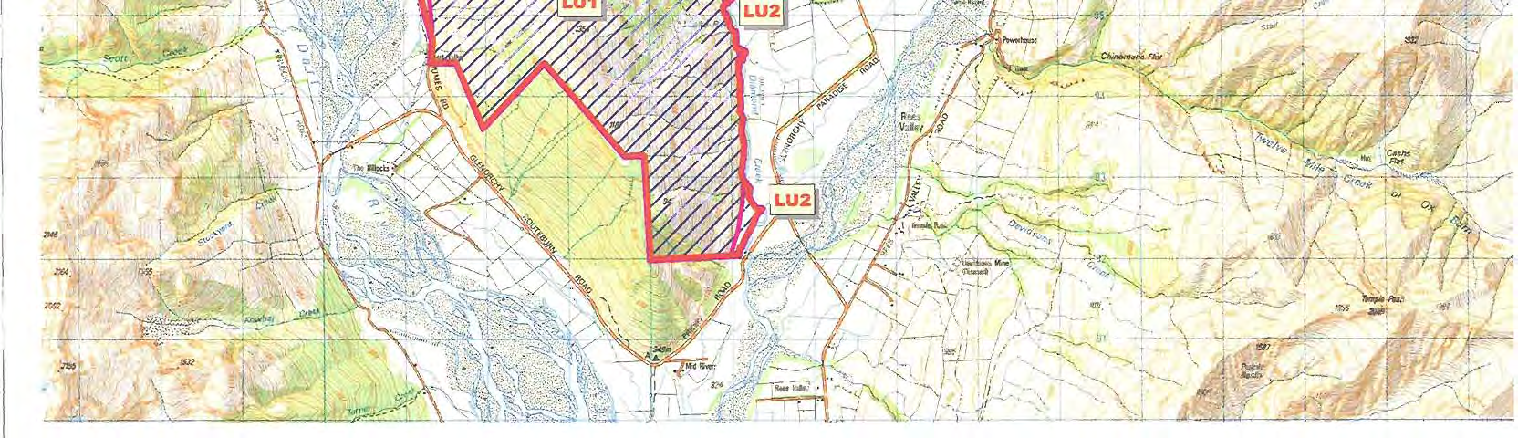

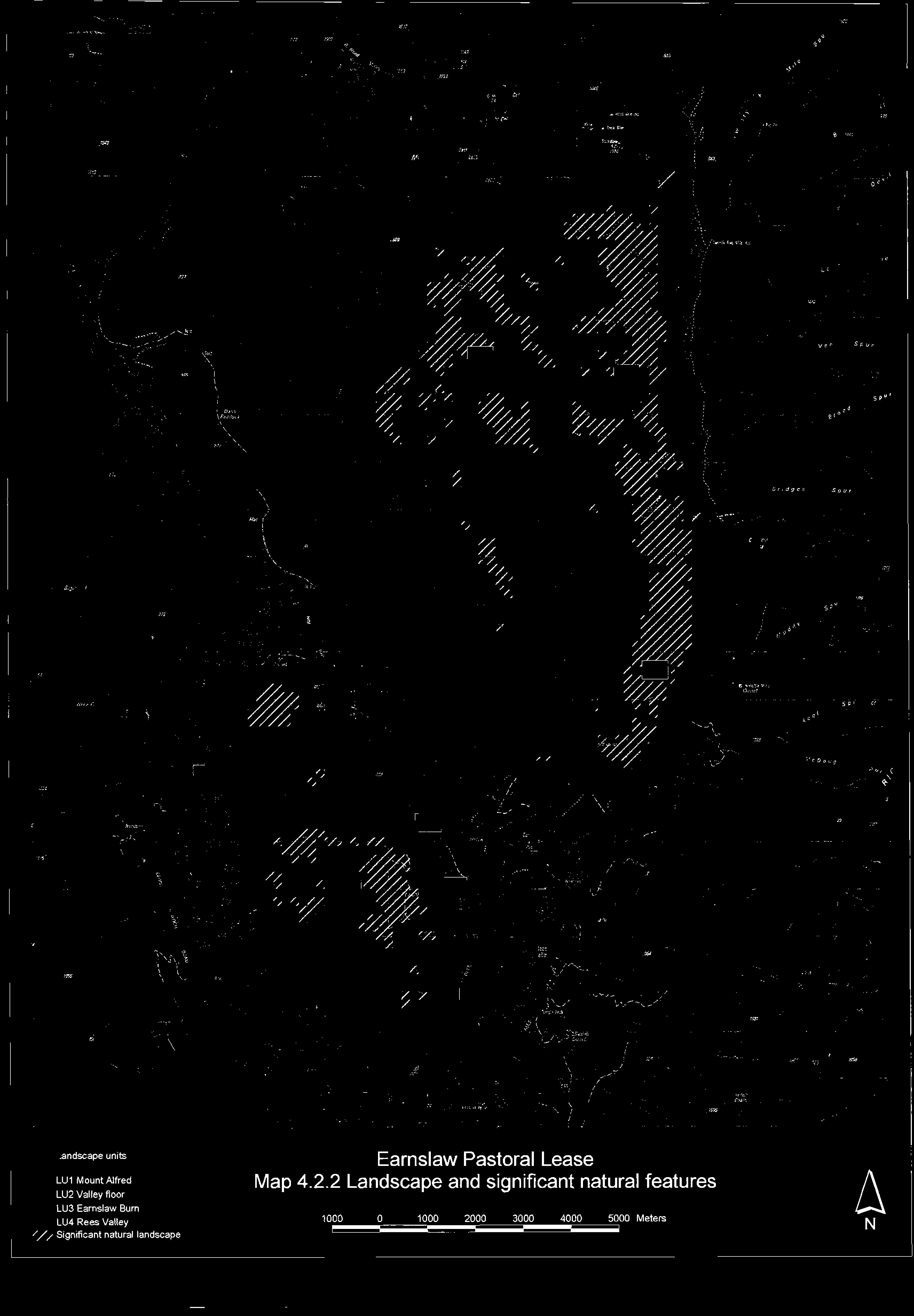
Item 02
Released under the Offical Information Act


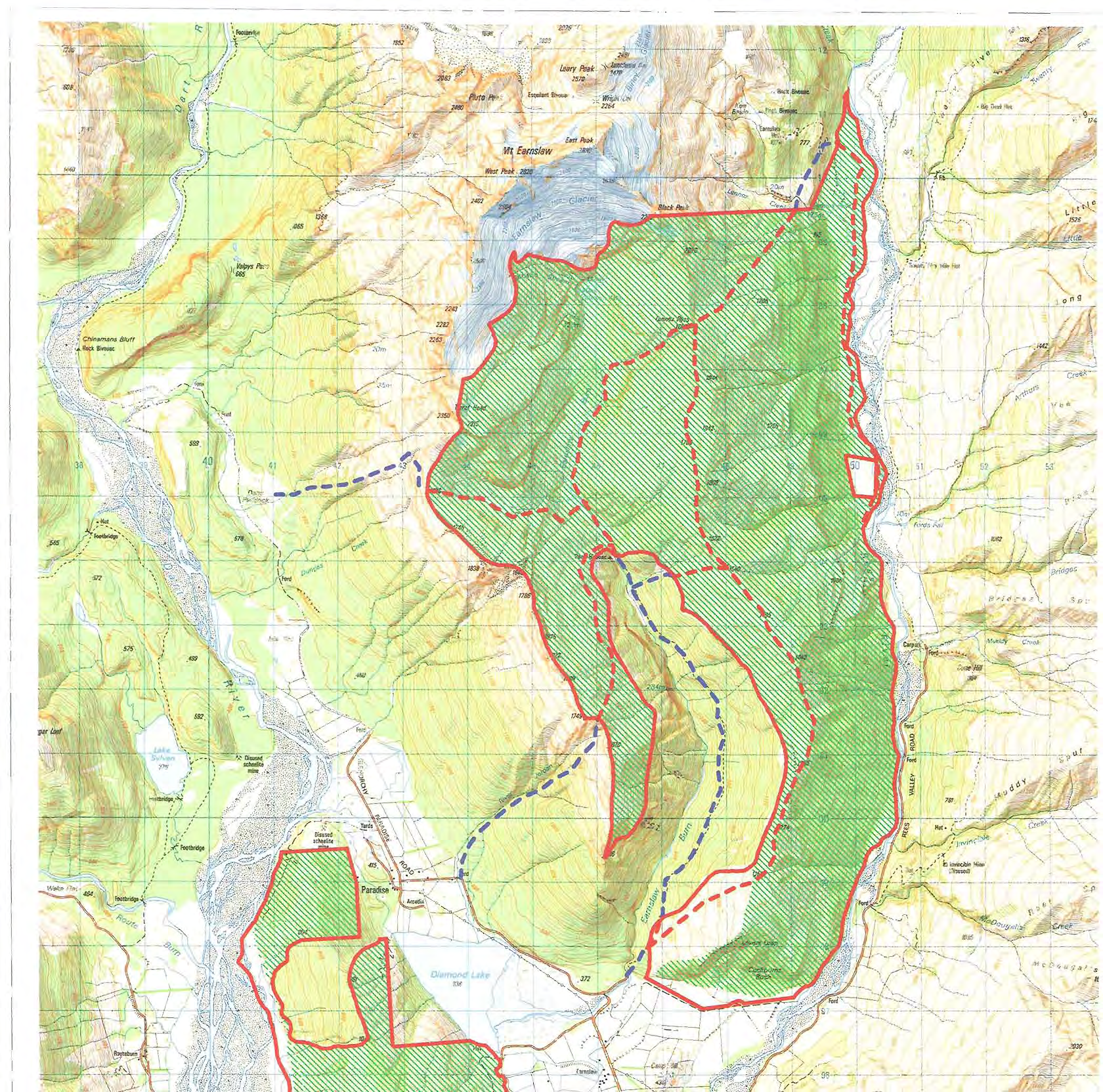


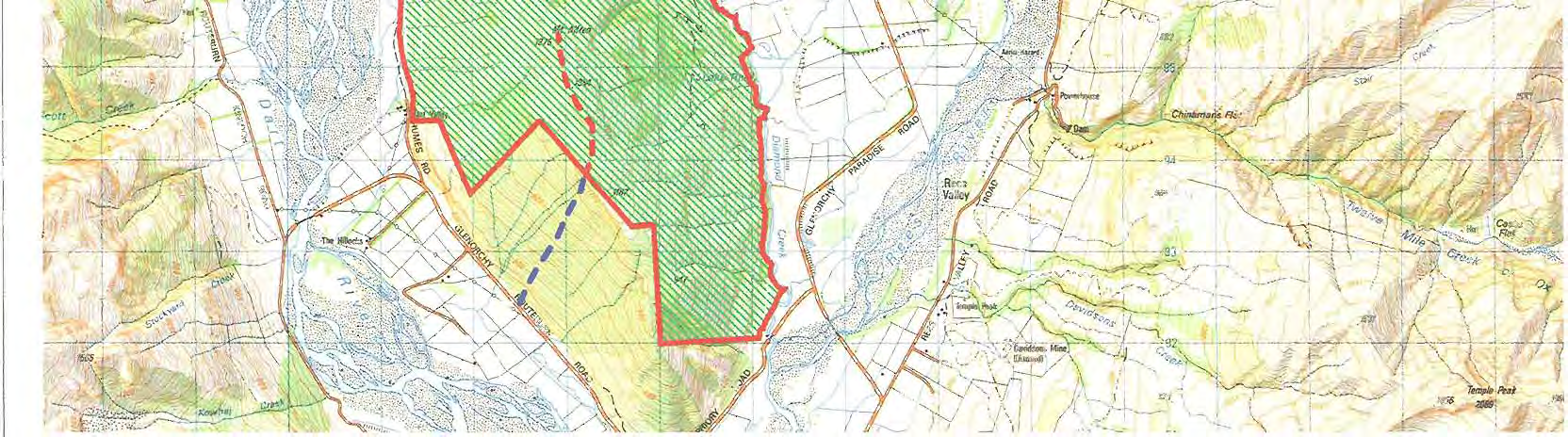

Item 03
Released under the Offical Information Act


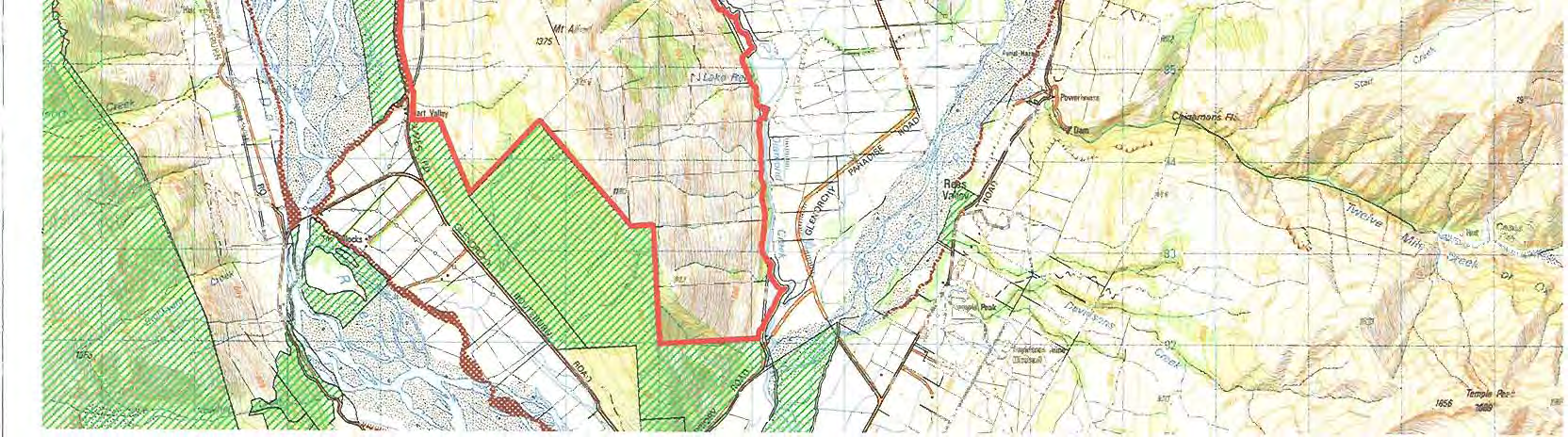
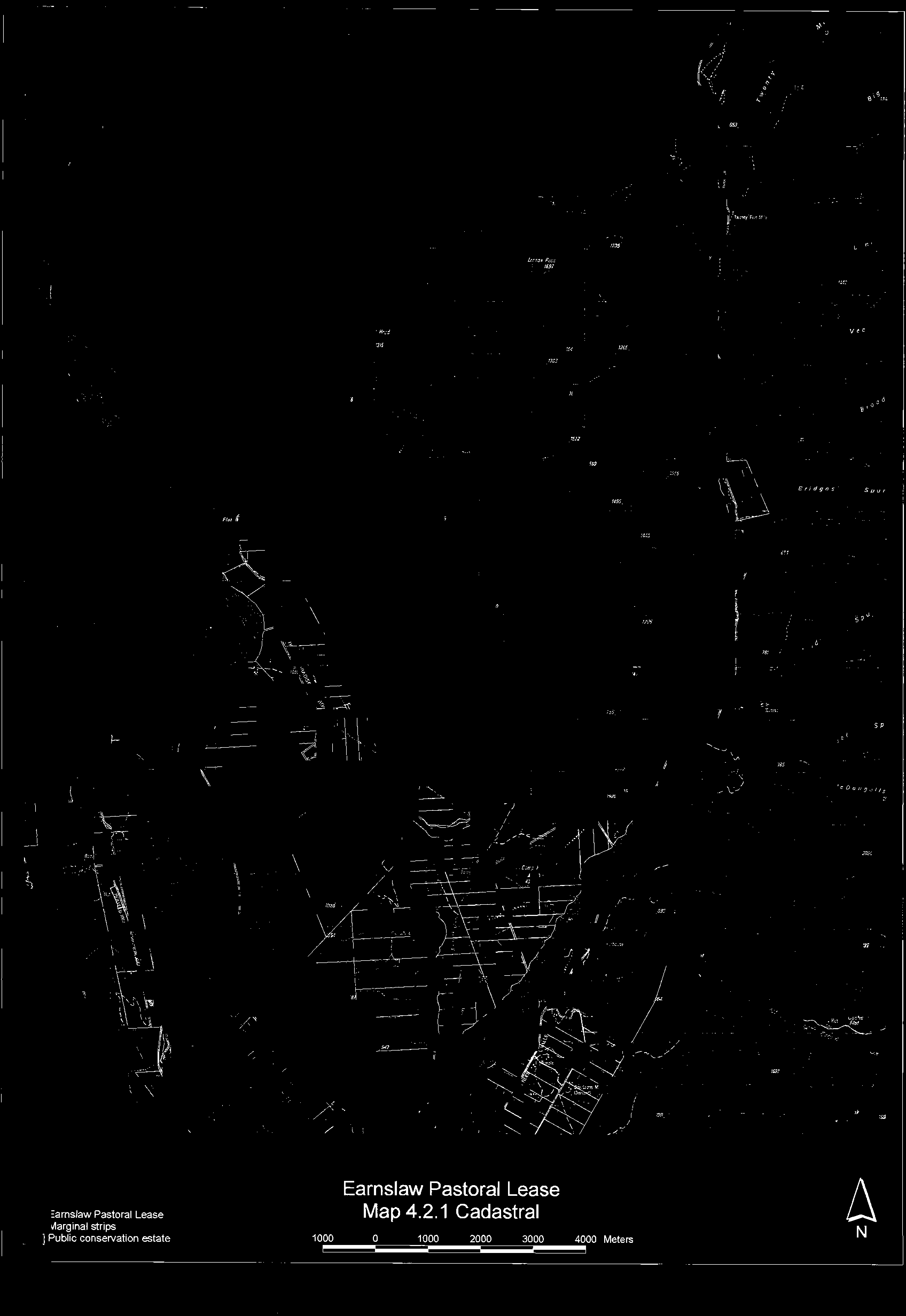
Item 04
Released under the Offical Information Act
Document Outline