
Crash data in Arrowtown 2020-2025
Cover sheet
Page 1 of 6
as at 22 Sept 2025
OIA-19476 - Crashes in Arrowtown 2020-2025
Report Date:
22/09/2025
Data extract date:
22/09/2025
Requester:
Natalia Galin
Request:
"…Could you please provide me with the address, and date information for all traffic
incidents around the Arrowtown area (postcodes: 9302, 9351 and 9371) for the years:
2020, 2021, 2022, 2023, 2024 and 2025?
Please provide the following information:
- address,
- date,
- severity..."
Source database:
CAS
Report produced by:
Statistical Services
Peer reviewed by:
Statistical Services
Please note the fol owing concerning the data contained in this spreadsheet:
• This data is provided from the road traffic crash database; Crash Analysis System (CAS) version 2.13.2.
• NZ Transport Agency Waka Kotahi (NZTA) maintains CAS which is updated once a Traffic Crash Report
(TCR) is received from New Zealand Police sometime after the crash.
• Data is for all crashes for the years 2020 to 2025 as recorded in CAS to date - as at 22 September 2025.
• 2025 data is not yet complete in CAS but these are the current figures from CAS as at 22 September 2025.
• Data is limited to crashes on roads in Arrowtown.
• A crash, to be recorded in CAS must have occurred on a road. The CAS definition of a road is any street,
motorway or beach, or a place to which the public have access with a motor vehicle, whether as of right or
not - for example, a public car park.
• Due to the police reporting time frame and subsequent data processing, there is a lag from the time of a
crash to full and correct crash records within CAS.
• Due to the nature of non-fatal crashes, it is believed that these are under-reported, with the level of under-
reporting decreasing with the increasing severity of the crash.
• Crash severity is the severity of the worst injury in the crash. There may be more than one injury in a crash,
under the Official Information Act 1982
so the crash and injury tables may have different numbers.
• The cause of a crash cannot necessarily be attributed to any one factor (for example, fatigue) as a crash
may have multiple factors.
• Due to the COVID-19 pandemic, New Zealand had a 4-level Alert system in place from 21 March 2020
until this changed to a Traffic Light system from 3 December 2021 to 12 September 2022. The amount of
traffic on the roads during Level 4 lockdowns was greatly reduced, which consequently reduced the
number of road crashes. Road movements under the Orange and Red levels of the Traffic Light system
would also be reduced due to the restrictions in place, so data from these periods wil not align with
previous trends.
Released
• CAS is continually updated as new information is provided, therefore data regarding injuries, and factors
attributed to crashes, may change from previous releases.
For further information, please contact [email address]
Crash data in Arrowtown 2020-2025
Data1
Page 2 of 6
as at 22 Sept 2025
This information must be read in conjunction with the Caveats on the first page of this spreadsheet.
Crashes on roads in Arrowtown, 2020-2025*
Year
Fatal crashes
Serious injury
Minor injury
Non-injury
crashes
crashes
crashes
Total crashes
2020
1
1
3
11
16
2021
3
8
11
2022
4
7
11
2023
5
6
11
2024
4
8
12
2025*
5
3
8
Total
1
1
24
43
69
Injuries from crashes on roads in Arrowtown, 2020-2025*
Year
Deaths
Serious injuries
Minor injuries
Total injuries
2020
1
2
4
7
2021
5
5
2022
4
4
2023
5
5
2024
4
4
2025*
8
8
Total
1
2
30
33
* 2025 data is not yet complete in CAS, but these are the current figures from CAS as at 17 September 2025.
under the Official Information Act 1982
Released
Crash data in Arrowtown 2020-2025 as at 22 Sept 2025
Maps
Page 3 of 6
This information must be read in conjunction with the Caveats on the first page of this spreadsheet.
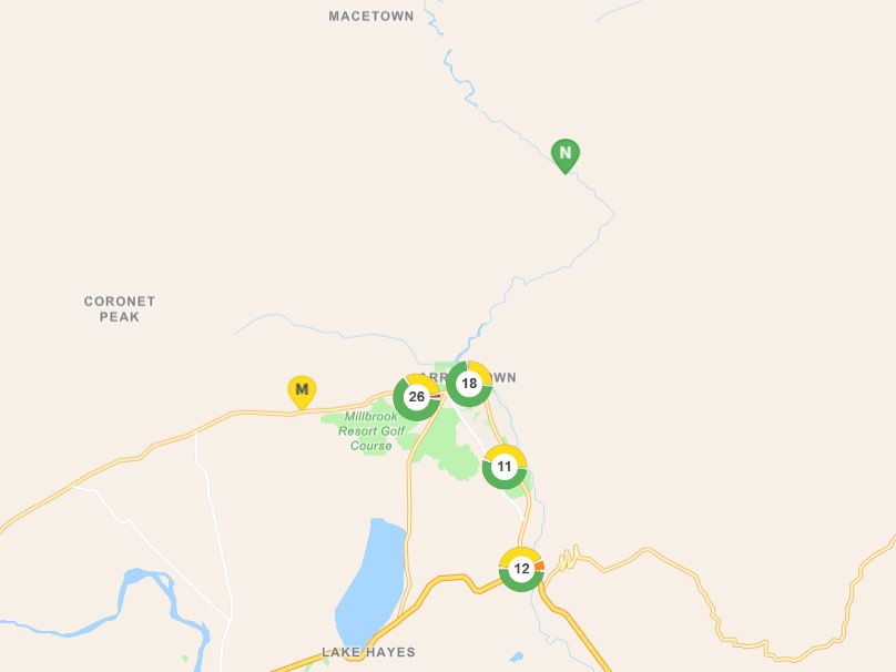
Map of 2020-2025* crashes on roads in Arrowtown
CAS wil group crashes that are near each other depending on the zoom level of the map.
This should not be interpreted as where crash hotspots are.
The number in the circle is the number of crashes on that section of road.
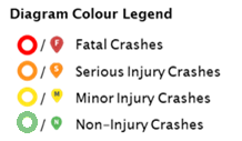
The colours around the circle show the proportion of crashes of different severities - see legend to the right of this diagram.
Where there are individual crashes that are not grouped, they show as single pin - see legend to the right of this diagram.
* 2025 data is not yet complete in CAS, but these are the current figures from CAS as at 22 September 2025.
under the Official Information Act 1982
Released
Crash data in Arrowtown 2020-2025
Crash location
Page 4 of 6
as at 22 Sept 2025
Crash date Crash road
Longitude
Latitude
Crash severity
31/01/2020 ORCHARD HILL
168.81999206542969
-44.94877243 Minor Crash
16/02/2020 CENTENNIAL AVENUE
168.85114999999999
-44.965854 Minor Crash
15/01/2020 CENTENNIAL AVENUE
168.851257
-44.962812 Non-Injury Crash
4/02/2020 ARROWTOWN-LAKE HAYES ROAD 168.82804999999999
-44.942547 Non-Injury Crash
28/05/2020 MCDONNELL ROAD
168.849164
-44.977435 Serious Crash
21/03/2020 DEVON STREET
168.84311199999999
-44.948231 Non-Injury Crash
31/03/2020 LAKE HAYES-ARROW JUNCTION
168.84399099999999
-44.979844 Non-Injury Crash
HIGHWAY
20/06/2020 NAIRN STREET
168.837346
-44.939037 Non-Injury Crash
1982
22/08/2020 MALAGHANS ROAD
168.80724900000001
-44.943674 Fatal Crash
13/09/2020 BEDFORD STREET
168.83666299999999
-44.939562 Minor Crash
22/01/2021 MALAGHANS ROAD
168.802886
-44.945137 Minor Crash
25/08/2020 WILTSHIRE STREET
168.83363499999999
-44.938738 Non-Injury Crash
Act
2/09/2020 ESSEX AVENUE
168.81747200000001
-44.93826 Non-Injury Crash
15/03/2021 BERKSHIRE STREET
168.829712
-44.940147 Minor Crash
18/09/2020 ARROWTOWN-LAKE HAYES ROAD 168.82776999999999
-44.943011 Non-Injury Crash
29/11/2020 ARROWTOWN-LAKE HAYES ROAD 168.82492999999999
-44.946728 Non-Injury Crash
7/12/2020 BERKSHIRE STREET
168.82972899999999
-44.940137 Non-Injury Crash
18/12/2020 ESSEX AVENUE
168.82027400000001
-44.938982 Non-Injury Crash
27/02/2021 MALAGHANS ROAD
168.81935200000001
-44.942491 Non-Injury Crash
23/03/2021 ARROWTOWN-LAKE HAYES ROAD 168.81966399999999
-44.952933 Non-Injury Crash
Information
12/02/2021 CRITERION STREET
168.83981199999999
-44.941852 Non-Injury Crash
27/04/2021 BUCKINGHAM STREET
168.834993
-44.939156 Non-Injury Crash
22/12/2021 CENTENNIAL AVENUE
168.84316100000001
-44.951945 Minor Crash
25/06/2021 HOOD CRESCENT
168.836061
-44.948387 Non-Injury Crash
27/03/2022 LAKE HAYES-ARROW JUNCTION
168.84920099999999
-44.977539 Minor Crash
Official
HIGHWAY
19/07/2021 MANSE ROAD
168.82155
-44.938905 Non-Injury Crash
12/12/2021 CENTENNIAL AVENUE
168.851358
-44.963686 Non-Injury Crash
the
7/01/2022 BERKSHIRE STREET
168.828215
-44.942321 Non-Injury Crash
7/11/2021 BUCKINGHAM STREET
168.833294
-44.938725 Non-Injury Crash
28/01/2022 BEDFORD STREET
168.838234
-44.941603 Non-Injury Crash
26/06/2022 ARROWTOWN-LAKE HAYES ROAD 168.81929700000001
-44.953431 Minor Crash
25/06/2022 GIBBSTON HIGHWAY
168.85067100000001
-44.977199 Minor Crash
under
12/01/2022 BUCKINGHAM STREET
168.83375899999999
-44.938869 Non-Injury Crash
6/02/2022 BRACKEN STREET
168.83566300000001
-44.947174 Non-Injury Crash
1/11/2022 MCDONNELL ROAD
168.833157
-44.948223 Minor Crash
2/09/2022 BUCKINGHAM STREET
168.831884
-44.938486 Non-Injury Crash
19/09/2022 BARLEY COURT
168.79369199999999
-44.949756 Non-Injury Crash
22/04/2023 BEDFORD STREET
168.836769
-44.939621 Minor Crash
24/04/2023 MALAGHANS ROAD
168.78739899999999
-44.946304 Minor Crash
11/06/2023 GIBBSTON HIGHWAY
168.85051000000001
-44.977193 Minor Crash
Released
20/06/2023 MCDONNELL ROAD
168.849098
-44.971182 Minor Crash
28/12/2022 MACETOWN ROAD
168.86174700000001
-44.899113 Non-Injury Crash
19/10/2023 LAKE HAYES-ARROW JUNCTION
168.84919400000001
-44.977551 Minor Crash
HIGHWAY
9/06/2023 CAERNARVON STREET
168.82959
-44.940095 Non-Injury Crash
27/06/2023 BERKSHIRE STREET
168.82820799999999
-44.942334 Non-Injury Crash
15/08/2023 GIBBSTON HIGHWAY
168.85108600000001
-44.977258 Non-Injury Crash
Crash data in Arrowtown 2020-2025
Crash location
Page 5 of 6
as at 22 Sept 2025
Crash date Crash road
Longitude
Latitude
Crash severity
15/08/2023 GIBBSTON HIGHWAY
168.85086799999999
-44.977221 Non-Injury Crash
11/03/2024 CAERNARVON STREET
168.82964799999999
-44.940151 Minor Crash
24/11/2023 CORNWALL STREET
168.84247199999999
-44.9472 Non-Injury Crash
30/12/2023 BERKSHIRE STREET
168.82976199999999
-44.940119 Non-Injury Crash
1/01/2024 BERKSHIRE STREET
168.82959700000001
-44.940214 Non-Injury Crash
20/02/2024 GIBBSTON HIGHWAY
168.84937400000001
-44.977439 Non-Injury Crash
27/02/2024 MALAGHANS ROAD
168.79395099999999
-44.945951 Non-Injury Crash
5/09/2024 BERKSHIRE STREET
168.829722
-44.940146 Minor Crash
28/08/2024 CENTENNIAL AVENUE
168.84277900000001
-44.951406 Minor Crash
27/04/2024 HERTFORD STREET
168.833313
-44.939966 Non-Injury Crash
1982
1/05/2024 LAKE HAYES-ARROW JUNCTION
168.84911399999999
-44.977591 Non-Injury Crash
HIGHWAY
12/05/2024 SURREY STREET
168.82786999999999
-44.938356 Non-Injury Crash
Act
12/11/2024 MALAGHANS ROAD
168.80430999999999
-44.94497 Minor Crash
10/01/2025 MALAGHANS ROAD
168.81475699999999
-44.94249 Minor Crash
1/11/2024 CAERNARVON STREET
168.82797099999999
-44.939163 Non-Injury Crash
20/11/2024 COTTER AVENUE
168.83662000000001
-44.949154 Non-Injury Crash
8/06/2025 MALAGHANS ROAD
168.819435
-44.942471 Minor Crash
16/05/2025 BERKSHIRE STREET
168.828169
-44.9418 Minor Crash
1/01/2025 LAKE HAYES-ARROW JUNCTION
168.84916999999999
-44.977552 Non-Injury Crash
HIGHWAY
23/02/2025 MCDONNELL ROAD
168.850176
-44.968532 Non-Injury Crash
31/08/2025 LAKE HAYES-ARROW JUNCTION
168.849154
-44.977572 Minor Crash
Information
HIGHWAY
11/09/2025 KENT STREET
168.83065199999999
-44.942377 Minor Crash
9/04/2025 ARROWTOWN-LAKE HAYES ROAD
168.828048
-44.94256 Non-Injury Crash
Official
the
under
Released
Crash data in Arrowtown 2020-2025 as at 22 Sept 2025
Factors
Page 6 of 6
This information must be read in conjunction with the Caveats on the first page of this spreadsheet.
Factors contributing to 2020-2025* crashes
on local roads in Arrowtown
Crash factor
Count
Alcohol and/or Drugs proven
9
Alcohol and/or Drugs suspected
5
Disabled, old age or il ness
0
Failed to give way or stop
19
Fatigue
1
Incorrect lanes or position
13
Miscellaneous factors
3
Overtaking
2
Pedestrian factors
1
Poor handling
11
Poor judgement
11
Poor observation
24
Position on Road
6
Road factors
9
Travel Speed
9
Vehicle factors
2
Weather
2
TOTAL factors
127
Factors are counted once against a crash - that is, two fatigued drivers count as one fatigue crash factor.
Count is the number of crashes where that factor was a contributing factor to the crash. The Total is the sum of all the factors contributing to crashes.
Because a crash may have multiple factors there wil be more total factors than crashes resulting in factors totalling more than 100% of all crashes
Where Alcohol and/or Drugs are a contributing factor to a crash, this factor has been separated into either "Proven" or "Suspected".
Where a crash has both a proven and suspected factor against it, only the factor "Proven" is counted.
* 2025 data is not yet complete in CAS, but these are the current figures from CAS as at 22 September 2025.
under the Official Information Act 1982
Released
Document Outline