
1982
Act
Former SH1 and SH1B Routes
Tamahere to Cambridge
Form and Function Statement
Information
Official
the
under
Released
Date: November 2015
Prepared by Out of Scope
1
1. Purpose and Background
Purpose
1.1 The opening of the Cambridge Section of the Waikato Expressway will affect the manner in which
the roading network operates. The provision of a new high standard route for strategic inter-
regional traffic will also provide opportunity to improve the amenity of the local road network,
which will experience notable traffic relief as a result of the Expressway. The purpose of this
statement is to confirm the new functions of the current routes of State Highway 1 (SH1) and State
Highway 1B (SH1B) through Cambridge, and in the light of the new functions, identify any required
improvements which may be required.
1982
General Background
Act
1.2 The Cambridge section of the Waikato Expressway is due to be opened in December 2015. As part
of the delivery of this project, there is a need for the NZ Transport Agency to revoke sections of
SH1 and SH1B, which provide connections between the Expressway, the urban area of Cambridge
and rural roads between Tamahere and Cambridge. There is an additional need to revoke two
short sections of State Highway 1 between Tamahere and Cambridge, which have been bypassed
by the Expressway, but retained as road, to form connections on the rural road network within
Waikato District.
1.3 Upon revocation, future responsibility for the majority of the sections of state highway will be
handed over to Waipa District Council as the local road controlling authority. However, two short
sections of the former SH1 between Tamahere and Cambridge, which will be retained as road
following the off-line construction of the Expressway, will be handed over to Waikato District
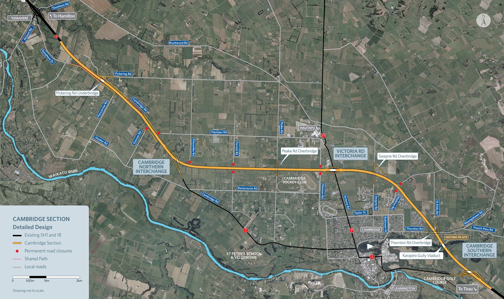
Council. A plan of the Cambridge section of the Expressway is shown in figure 1.1 below.
Information
Figure 1.1 Waikato Expressway – Cambridge Section
Official
the
under
Released
2
Overview of the Cambridge Section of the Waikato Expressway
1.4
As shown on the previous page of this statement, the Cambridge section encompasses the
following three grade-separated interchanges:
• Interchange with Cambridge Road – The western-most interchange of the Cambridge
section, consisting of north-west facing ramps only. Its function will be to provide access to
the western side of Cambridge, including Velodrome.
• Victoria Road Interchange – This will be a ‘diamond’ interchange providing full access to
Victoria Road, including SH1B to the north, following the opening of the Expressway. Waipa
1982
District Council favour this interchange becoming the main gateway into Cambridge from the
north, rather than via the interchange with Cambridge Road.
• Interchange with Tirau Road – The eastern-most interchange of the Cambridge section and
terminus of the Waikato Expressway, consisting of east-facing ramps only. Its function will be
Act
to provide access to eastern and southern parts of Cambridge, including Leamington, as well
as onward destinations to the south such as Te Awamutu.
NZ Transport Agency ‘State Highway Revocation: Policy and Guidance’ Note
1.5 This Policy and Guidance Note sets out the rationale and process associated with the revocation of
state highways, including consultation requirements, timeframes, funding, wider network
considerations and works required prior to handover. It states that:
• “…
[the NZ Transport Agency] should not retain state highways (SH) that serve substantially
the same function for the surrounding network”.
•
“… if the road is still required for use as a local road, the NZ Transport Agency must
Information
recommend to the Chief Executive of the Ministry of Transport that the SH status of the road
be revoked”.
•
“If the NZTA recommends that state highway status should be revoked, it must ensure that the
road will at the time of handover, be fit for purpose in relation to its transport functions.”
•
“Fit for purpose means that at the time of handover the revoked section of SH will provide a
level of service equivalent to other roads providing a similar function within the local road
network, and be safe…”
Official
•
“Removing the state highway traffic (as a consequence of building the new road), and ensuring
that maintenance on the revoked section of SH is up to date (in accordance with the state
highway asset management plan), will in most cases meet both the safety and level of service
expectations of the fit for purpose standard.”
the
Revocations following the opening of the Cambridge Section of the Expressway
1.6
The sections of road under consideration for revocation, following the opening of the Cambridge
Section, are best described in the following four sections, as described below and illustrated in
Figure 1.2:
under
• Western Section (SH1),
Waipa District (except for a section of around 350 metres in length to
the north of Racecourse Road, which lies in Waikato District *
): Extends from north of
Racecourse Road in the north to Kelly Road on the western perimeter of Cambridge.
• Urban Section (SH1),
Waipa District: Extends from Kelly Road, through Cambridge and out to
the Karapiro Stream Bridge, immediately to the west of the intersection with Shakespeare
Street.
• Eastern Section (SH1),
Waipa District: Extends from the Shakespeare Street intersection to just
past the end of the Golf Course, where the road curves in a south west direction.
• Victoria Street Section (SH1B),
Waipa District: Extends from Hamilton Road in the south to 500
Released
metres south of Hautapu Road (location of the new Victoria Road Expressway Interchange)
• Rural Sections (SH1),
Waikato District:
o Tamahere Drive, between the Tamahere Interchange and its downstream at-grade
intersection with SH1
(although this former section of SH1 is already bypassed by the
existing length of Expressway encompassing the Tamahere Interchange, it was never
3
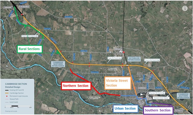 legally revoked. However, it is already maintained by Waikato District Council,
therefore this will not affect current maintenance responsibilities)
o between Tamahere Drive and 200 metres north of Pencarrow Road
o between Duncan Road and a point approximately 300 metres south of Hautapu Road
* Based on discussions of the Expressway Revocations Working Group, Waipa and Waikato District
Councils have agreed in principle that, following revocation, the whole of the ‘Western Section’ of
the former SH1 would be maintained by Waipa District Council, under agreement between the
two councils.
1982
Figure 1.2 Current SH1 and SH1B Corridor Sections
Act
Information
Official
1.7
This statement considers the functions that these revoked lengths of road will be required to fulfil
in the short and longer term and thus considers any works that may be required to enable them to
the
fulfil their future function.
Review of the strategic function of Cambridge Road between Te Awamutu and Cambridge
1.8
Through the Waikato Expressway Revocations Working Group, Waipa District Council expressed
interest in considering the case to declare a new state highway between Te Awamutu and
Cambridge, following the route of Golf Road / Cambridge Road / Pope Terrace / Cook Street /
under
Shakespeare Street / Tirau Road. The proposed route would thus encompass an existing section of
SH1 along Tirau Road, and connect with the Cambridge Section of the Expressway at its Southern
Interchange.
1.9
Following the submission of evidence by Waipa District Council to support a renewed case for
declaring a state highway between Cambridge and Te Awamutu, in July 2014, the Transport
Agency’s review of this case concluded that it remained unviable. This case is outlined in more
detail in Appendix B of this statement, along with its review by the Transport Agency.
Released
4
2. Strategic Context
NZ Transport Agency Waikato Expressway Network Plan
2.1 The Transport Agency’s Waikato Expressway Network Plan sets out guidance and support towards
on-going integrated planning and decision making associated with the Waikato Expressway and its
associated sub-regional network. This includes principles to guide the revocation of state highway
sections, and acknowledgement of the need for the Transport Agency to revoke state highways in
instances where the routes will continue to perform an important local function once the
1982
Expressway opens.
2.2 In the case of Cambridge, the Network Plan recognises future land use pressures which are
expected to arise from growth in Tamahere and Cambridge, which is expected to put pressure on
the Expressway south of Hamilton. The Network Plan highlights the strategic aim to reduce local
Act
trips on the Expressway between Cambridge and Hamilton and the need to improve public
transport connections between Cambridge and Hamilton. The Network Plan also identifies the
Futureproof aim for employment self-sufficiency within the town, taking into account constraints
including interchange capacity. This includes optimising the allocation of strategic employment
land at Hautapu.
2.3 The Network Plan highlights the following key issues relating to future form and function of SH1
and SH1B through Cambridge, following the opening of the Expressway:
• The significant change in function of SH1B at the Victoria Road interchange following the
opening of the Expressway, reflecting the change from a predominantly rural northern section
to a more urban environment between Hautapu and Cambridge town centre
• Opportunities to enhance community outcomes, urban design and amenity following the
Information
removal of large volumes of through traffic
• The need for recommendations relating to future form and function to be informed by Waipa
Town Concept Plan and Waipa Integrated Transport Strategy
• Safety benefits are potentially achievable through removing through traffic from Cambridge,
thus reducing conflicts with local traffic, particularly through the removal of Heavy goods
vehicles. This will also facilitate the movement of High Productivity Motor Vehicles on SH1.
• Scope for improved walking and cycling within the urban area of Cambridge
Official
Waikato Regional Land Transport Strategy
the
2.4 The current Waikato Regional Land Transport Strategy (RLTS) identifies the future land transport
needs of the Waikato Region for the period 2011 to 2041 and the most desirable means to
respond to those needs in a safe, cost-effective and environmentally sensitive manner.
2.5 The RLTS recognises the routes of State Highways 1 and 1B through Cambridge as strategic
corridors, which will experience a change in function as a result of the Waikato Expressway. It also
recognises the route of Cambridge Road / Pope Terrace between Te Awamutu and Cambridge as a
strategic corridor, of sub-regional significance. However, the RLTS does not refer to the case for
under
the route to become state highway in the future.
Strategic corridor
Desired function 1-10 years
Desired function 11-30 years
Existing
Nationally State highway which connects
Long term function to be
State
significant service centres of Ngaruawahia,
determined following completion of
Highway 1
Huntly, Cambridge and Hamilton the Waikato Expressway. Likely shift
(Pokeno to
whilst the expressway is being
in function from inter-regional
south
constructed.
movement to intra-regional
Cambridge)
movement and connectivity.
State
sub-
State Highway 1B functioning as
State Highway 1B will become a
Highway 1B
regionally
alternative bypass of Hamilton
local rural arterial once the
Released
(including
significant and providing north-south link
Hamilton section of the Waikato
Gordonton
between urban and rural areas in Expressway is completed.
Road)
the east of Hamilton.
Cambridge
sub-
Rural arterials connecting the
No significant change expected.
Road & Pope
regionally
service centres of Cambridge
5
Terrace (Te
significant and Te Awamutu. Provides
Awamutu to
access for dairy industry and
Cambridge)
inter-district freight movement.
2.6 Policy P8.13 of the RLTS places the Waikato Expressway as the number one strategic transport
project for the Waikato Region.
2.7 Policy P8.16 of the RLTS recognises the need to ensure bypassed sections of State Highway
continue to respond to local transport requirements following the completion of the Waikato
Expressway. Policy P 8.16 recognises the opportunity for bypassed towns such as Cambridge to be
enhanced as a result of a reduction in through traffic. This will lead to improved internal journey
1982
time reliability, improved safety, and enhanced urban amenity outcomes within the urban areas.
Opportunities for improved public transport services in these urban areas will be enhanced. A key
Action of the RLTS is for the NZ Transport Agency and local authorities concerned to determine the
future roles and functions of the bypassed sections of State Highway 1 from the Waikato
Act
Expressway.
Waipa Integrated Transport Strategy
2.8 The Waipa Integrated Transport Strategy (WITS), finalised in December 2010, sets the strategic
direction for transport in Waipa over the 30-year period to 2040. The Strategy provides the basis
for integrated transport and land use planning consistent with the vision of the Waipa 2050
Growth Strategy. An implementation plan details the phasing, cost and funding of the
implementation activities and packages of work for the implementation plan.
2.9 The Strategy identifies the problems within Cambridge of having a State highway running through
its town centre and the resultant conflict between local and through traffic. It recognises that this
results in particular congestion issues within the town centre. The strategy identifies that there will
Information
be a significant improvement to all traffic movements upon construction of the expressway.
2.10 The Strategy identifies several outcomes for Waipa District as a result of construction of the
expressway, including:
•
Reduction in congestion and intersection delays
•
Improved safety for local pedestrians, horse riders, cyclists, and traffic
•
Reduced traffic noise within the confines of Cambridge town
•
Opportunity to redevelop the local road network following removal of State highway traffic
Official
•
Opportunity to enable future population growth to develop around existing Waipa District
towns including Cambridge (facilitated through review of District Plan)
•
Opportunities to promote bus transport through enhanced local road infrastructure and
encourage increased walking and cycling through the development of connected networks
the
2.11 In particular, Waipa District Council has identified a number of projects that aid in implementing
the Strategy, which have been packaged together and suggested to be developed in parallel with
progression of the Expressway. These include:
• Cambridge Town Centre Plan Implementation
• Corridor Management Plans for Old State Highway 1 and State Highway 1B, including
investigation into future form and function of routes post-expressway.
under
• Victoria Road Interchange and associated roading upgrades
• Cambridge Norfolk/Victoria Link construction
• Cambridge Park and Ride Facilities investigation
• 3rd Bridge investigation and land purchase
• New footpaths and crossing improvements
Waipa District Walking and Cycling Strategy
2.12 The Waipa District Walking and Cycling Strategy 2008 has been developed with the aim of
encouraging walking and cycling within the District as a safe and convenient mode of transport.
Released
2.13 The Council has identified three key objectives for cycling and four objectives for walking, which
range from improved safety of users and providing an environment that supports walking/cycling,
to identification and completion of additional walking/cycling networks.
2.14 The strategy identifies narrow carriageways, particularly on bridges, as ‘pinch points’ to address.
Two such bridges on or adjoining the state highway routes to be revoked are the Karapiro Stream
6
Bridge, to the west of the Shakespeare Street intersection on Achilles Avenue, and the Fergusson
Bridge, at the northernmost end of Shakespeare Street. As noted in paragraph 2.21, the current
Waipa District 10-Year Plan proposes footpath widening on the Fergusson Bridge.
2.15 Waikato Regional Council have recently commenced the development of a business case, to
consider cycling needs at a regional level. This will include consideration of catering for different
cycling trip purposes, such as tourism and commuter trips. However, at the time of writing, this
business case has not yet been progressed to a level of being able to inform the development of
specific cycle routes in and around specific geographical areas, such as Cambridge.
Te Awa ‘The Great New Zealand River Ride’ Cycleway
1982
2.16 The Te Awa cycleway is a partially-completed 70km route which follows the river Waikato between
Ngaruawahia and Lake Karapiro, to the south of Cambridge. It forms a similar strategic route to
that of SH1 to the north and south of Hamilton, following a combination of a dedicated route along
the banks of the river and some local roads. The project is being driven by the Te Awa River Ride
Act
Charitable Trust. The route has been opening in phases since October 2010, and is currently due
for completion by 2016.
2.17 Between Hamilton and Karapiro, to the south of Cambridge, the route of the Te Awa Cycleway runs
off-line of SH1, alongside the river Waikato. It also includes a link to St Peter’s School and
Velodrome National Cycling Centre of Excellence, as well as links to other development areas
between the cycleway and Cambridge Road. The section between the Avantidrome and Leamington
opened in April 2014 and the section between the Avantidrome and Hamilton is due for
completion in 2016.
Waipa District Council 10-Year Plan
2.18 In accordance with requirements the Local Government Act 2002, Waipa District Council prepares a
Information
10-Year Plan, which highlights key activities of the council and shows the whole picture of how
these are managed, delivered and funded. The Plan is reviewed and updated every three years, and
at the time of writing, the draft 10-year Plan for 2015 – 2025 was awaiting final approval, at the
end of June 2015. This will replace the current 10-Year Plan for 2012-22.
2.19 The Plan acknowledges that the Expressway will reduce traffic congestion in the town, improve
safety as a result of the reduction in through traffic and reduce noise. The plan also states that
revoked sections of State Highway will be reformed to suit the future traffic and land use patterns.
Official
2.20 The Plan includes consideration of transport within Cambridge and proposes a series of projects to
improve traffic flows within the town, following the construction of the Expressway. The most
significant of these is a proposed upgrade of Victoria Road between the Expressway interchange
and Hamilton Road, which is expected to become the primary gateway into Cambridge. This
the
project would also include an upgrade to the intersections of Victoria Street / Hamilton Road,
which is currently being developed for implementation immediately post-Expressway, and Victoria
Road / Norfolk Drive, which is programmed for 2015/16.
2.21 The upgrade of Victoria Road is a key project within the plan that is intended to improve traffic
flows between the Victoria Road interchange at Hautapu and the intersection with Hamilton Road.
Previous proposals considered have included a median divided carriageway based on the existing
under
road layout, provision of on-road cycling facilities and wider footpaths. However, this proposal
would however require land that is currently designated for rail, as required by KiwiRail. Funding
for improvement works through the 10-Year Plan is currently available for early 2016, immediately
following Expressway opening. Details of upgrade works were unavailable at the time of writing.
2.22 Other key programmed projects affecting the future form and function of the current state
highway corridors include:
• Cambridge Road / Hanlin Road intersection improvement (near Velodrome) – Funding for
2019/20
• Queen Street improvements to urban amenity – Funding for 2020/21
Released
• Albert Street / Queen street intersection improvement – Funding for 2024/25
• Investigation into the timing and future location of a further river crossing (bridge) in
Cambridge. The investigation is planned for 2016 when further Census and traffic modelling
data will be available.
7
• Shakespeare Street / Tirau Road intersection upgrade, to allow better traffic flow following the
removal of traffic from the current route of State Highway 1
(As noted in paragraph 4.18, a
permanent roundabout had recently been completed at this location at the time of writing)
• Fergusson Bridge Footpath widening (immediately to south of Shakespeare Road / Tirau Road
intersection), to improve level of service for pedestrians – Funding for 2018/19
2.23 The 10-Year Plan Programme additionally includes a number of projects for local roads which are
due to be severed by the Expressway, or experience a traffic impact as a result of the Expressway.
The local roads in question include Swayne Road, St Kilda Road, Thornton Road / Albert Street and
Robinson Street. However, as discussed in paragraphs 3.12 and 3.13, the scale of the traffic
impact on these local roads has previously been assessed as being less than minor and is not
expected to impact upon the functions of the sections of state highway identified for revocation.
1982
Cambridge Town Concept Plan
Act
2.24 This study looked at a range of development sites following consultation with community groups
and the town centre plan visioning workshops. There are two significant elements related to the
revocation of the State highways within Cambridge:
1. State Highway 1 is seen as a barrier to the development of a thriving community. Following the
completion of the Waikato Expressway, additional traffic calming measures could help
overcome the pedestrian barrier created by the former State Highway and its surrounding
motor vehicle oriented uses.
2. Relocation of the current northern town centre entrance from the corner of Victoria Street /
Alpha Street to the corner of Victoria Street / Hamilton Road and creation of a north-eastern
CBD entrance landscaped gateway at the corner of Anzac Street /Queen Street. The southern
entrance is already well established, as Victoria Street Bridge is crossed over Extension of
streetscape. There is potential for:
Information
• Continuing existing streetscaping (landscaping, paving, awnings, street furniture etc) in
the CBD, beyond Victoria Street.
• Improving the streetscaping of the former State Highway 1 between Victoria Street and
Albert Street
Key Development within the Cambridge Area
Official
2.25 Cambridge is identified in both the Future Proof and Waipa 2050 Growth Strategies as a location
for significant urban growth, potentially almost doubling beyond its current size, to around 25,000
people by 2061 (based on Future Proof forecasts). The additional transport demand generated by
this growth will impact upon the current state highway corridors through Cambridge, which are
the
under consideration for revocation.
2.26 The Future Proof Growth Strategy is a sub-regional growth strategy encompassing Hamilton City,
and the Waikato and Waipa Districts. The Strategy provides a framework for managing growth
within this sub-region.
2.27 The Waipa 2050 Growth Strategy provides the local context to the sub-regional Future Proof
under
strategy. It has been developed to reflect the Future Proof settlement pattern, and gives a good
indication of future land use development within the Waipa District (WpDC). The Figure 2, below
shows the plan for land use (including industrial land), for Cambridge out to 2050.
2.28 Staged growth is planned to occur in a number of growth cells, mainly to the north and west of
Cambridge’s existing town boundaries. Growth is also planned for the southeast, and northeast of
the town. 80 hectares of industrial growth is included in the plans and is confined to the north of
the town on the northern side of the expressway. WpDC completed a review of the Waipa District
Plan, which was notified in May 2014, and now gives effect to the land use plan in the Waipa 2050
Growth Strategy.
2.29 The following table provides some additional information relating to key development cells
Released
identified in the Waipa 2050 Growth Strategy that are particularly relevant to the expressway.
These are also illustrated in Figure 2.
Growth Cell
Size (ha,
Indicative
Point of impact upon former SH1
dwellings, etc.)
timeframe
/ SH1B routes
8
Cambridge North
910 dwellings
2009 – 2031 Victoria Road / Victoria Street
Residential Growth Cell
(between Taylor Street &
Expressway)
St Kilda Residential
300 dwellings
2011
Victoria Road
(between Taylor Street
Development (north-east
onwards
& Expressway)
Cambridge)
Hautapu and C8
90ha of
Staged from
Victoria Road
(north of Expressway
Industrial Growth Cell
industrial land
2013/14
interchange)
onwards
Cambridge West
1920 residential
Staged from
Connection to Cambridge Road
dwellings within
2026
(between Kelly Road and Peake
a 160 ha area
onwards
Road)
1982
Cambridge North
Approx. 1600
Victoria Road
(between Taylor Street
Deferred Residential
dwellings
and Expressway)
Zone Structure Plan
Hautapu Draft Structure
96Ha
Subj. to
Victoria Road
(north of Expressway
Act
Plan
notification of
interchange)
plan change
Figure 2: Waipa 2050 Proposed Development Areas
Information
Official
the
under
2.30 Cambridge is also the home of the National Cycling Centre of Excellence (Velodrome), adjacent to
St Peters School to the north-west of Cambridge, which opened in April 2014.
Passenger Transport
Released
2.31 Currently, the key passenger transport service provided in the study area is the Leamington /
Cambridge to Hamilton service, which runs three services per day, Monday to Friday. The Regional
Passenger Transport Plan recommends that further investigation be undertaken to increase the
service level of the existing route and consider including services to provide access to local
schools.
9
3. Existing and Desired Future Functions of SH1 and SH1B routes though
Cambridge
Forecast Traffic Impact of Expressway upon former routes of SH1 and SH1B through
Cambridge
3.1
As a result of the Expressway, there is expected to be a significant redistribution of strategic and
local traffic movements through Cambridge. The Waikato Regional Transport Model (WRTM)
predicts Average Daily Traffic (ADT) flows on the road network for the years 2010 and 2021, as
1982
summarised below.
Traffic volumes on routes of SH1 and SH1B through Cambridge
Act
2010
2021
(Pre-Expressway)
Expressway open
Without Expressway
Current route of SH1 Western
12,600
19,700
Section
(north-west of Victoria
17,100
(-26%)
(+15%)
Street) Current route of SH1Eastern
8,600
18,000
Section
(south-east of Victoria
15,100
(-43%)
(+19%)
Street) Current route of SH1B between
11,400
8,900
Cambridge town centre and
6,500
(+75%)
(+37%)
Expressway
Information
3.2
SH 1
The above comparison indicates that the Expressway will result in a notable redistribution
in traffic levels from the current route of SH1 through the town to the expressway. This equates to
a 26% reduction in traffic flows to the west of the town centre and a 43% reduction in traffic to the
east of the town centre. This is anticipated to include the majority of HCV traffic currently using
the route, particularly to the east of the town centre, where there is no significant industrial land
use.
3.3
SH1B Traffic flows are expected to increase significantly on the current SH1B (Victoria Street)
Official
urban corridor, following the opening of the Expressway, This reflects the route becoming the
primary access into Cambridge from the north. However, it is notable that traffic levels on this
route would still be lower than those on the former route of SH1 to the west of Cambridge town
centre, and still fall within the capacity of Victoria Street in its current form.
the
3.4
Completion of the expressway will result in immediate improvements to the urban amenity within
Cambridge. It will also serve to improve safety and reduce the effect of severance created by
existing heavy traffic levels on SH1.
3.5
Based on guidance in the NZ Transport Agency’s Planning Policy Manual, the forecast post-
Expressway traffic volumes and removal of the majority of heavy commercial vehicles on the
revoked sections of state highway are considered not to warrant the provision of passing
under
opportunities.
Summary of existing and desired future Functions of SH1 and SH1B routes through
Cambridge
3.6
The core function for the Cambridge Section of the Waikato Expressway will be to assume the
status of SH1, as the national State Highway forming the main north-south axis across New
Zealand. This change in function will serve to remove through traffic from the centre of
Cambridge, allowing the current route of SH1 to cater more effectively for local functions. In turn,
the current route of SH1B via Victoria Street will serve as the new primary access into the town
Released
from the Expressway, via the Victoria Road Interchange. Additional secondary access into
Cambridge from the Expressway will be provided by interchanges to the east and west of the town.
3.7
The following tables outline the key functions fulfilled by the current routes of SH1 and SH1B
through Cambridge, both prior to and following the completion of the Expressway. These confirm
that the post-Expressway functions of the routes in question will be consistent with those of local
roads, hence confirming the case for revocation. Furthermore, the Expressway is the only route
10
which is identified as fulfilling a state highway function upon its opening, thus no other route is
identified for declaration or retention as a state highway.
Route of SH1 Western Section – Cambridge urban fringe to northern interchange with
Expressway
Existing function (pre-Expressway)
Desired Future function (post-Expressway)
• National State Highway linking upper • Peri-urban arterial providing connectivity
North Island with Tauranga (via SH29),
between western Cambridge and
Taupo and Wellington
destinations to the north and west
including Hamilton, via the Waikato
1982
• Arterial route for commuters and freight
Expressway.
between Cambridge and Hamilton
• Local access to rural properties and
• Arterial access between the SH1 to the
businesses (including St Peters School
north of Cambridge and Cambridge itself
Act
and Velodrome)
• Local access to and from residential areas • Local access to growth cells via side
and other urban amenities along the
roads
route, such as St Peter’s School
• Increasing use for walking and cycling
• Safe access to Velodrome, for cyclists as
access between Cambridge town centre
well as for motorised vehicle traffic
and Velodrome
Route of SH1 Urban Section – Cambridge town centre
Existing function (pre-Expressway)
Desired Future function (post-Expressway)
Information
• National State Highway linking upper • Urban arterial providing both local and
North Island with Tauranga (via SH29),
intra-regional connectivity to the
Taupo and Wellington
Cambridge town centre
• Arterial route for commuters and freight • Local access to residential properties,
between Cambridge, Hamilton and
retail and commercial developments
southern destinations
• Key walking and cycling route connecting
Official
• Local access to businesses and roadside
providing connectivity with the
premises and on street parking
Cambridge town centre
• Local access to residential and
commercial areas via side roads.
the
Route of SH1 Eastern Section – Cambridge urban fringe to southern interchange with
Expressway
Existing function (pre-Expressway)
Desired Future function (post-Expressway)
under
• National State Highway linking upper • Urban arterial, providing both local and
North Island with Tauranga (via SH29),
intra-regional connectivity, between
Taupo and Wellington
Cambridge town centre, SH1 and
destinations in the south
• Arterial route for commuters and
commercial traffic between SH1 to the • Arterial route for commuters and
south, Leamington, Cambridge and other
commercial traffic between SH1 to the
destinations via the intersection with
south, Leamington, Cambridge and other
Shakespeare Street
destinations via the intersection with
Shakespeare Street
• Local access to rural properties and
Released
businesses (including golf course)
• Local access to rural properties and
businesses (including golf course)
11
Route of SH1B Victoria Street Section – Cambridge town centre to Victoria Road interchange
Existing function (pre-Expressway)
Desired Future function (post-Expressway)
• Strategic north-south access between • Urban arterial corridor connecting the
Cambridge and Taupiri, and onward
Cambridge town centre with the Waikato
destinations to the north and south on
Expressway, increased industrial
SH1, avoiding Hamilton
development at Hautapu and residential
1982
areas in Cambridge North
• Local access between Cambridge and
rural hinterland to the north of the town, • Local access to residential properties,
including Hautapu Dairy Factory
retail and commercial developments
Act
• Local access to and from Cambridge • Key walking and cycling route connecting
northern residential areas
Cambridge town centre with residential
areas in Cambridge North
Route of SH1 Rural Sections between Tamahere and Cambridge
• Tamahere Drive, between the Tamahere Interchange and its downstream at-grade
intersection with SH1
• Between Tamahere Drive and 200 metres north of Pencarrow Road
• Between Duncan Road and a point approximately 300 metres south of Hautapu Road
Information
Existing function (pre-Expressway)
Future function (post-Expressway)
• National State Highway linking upper • Access to local properties on Tamahere
north island with Tauranga (via SH29),
Drive, Pickering Road, Pencarrow Road,
Taupo and Wellington
Hooker Road
• Direct Access between State Highway 1 • Access to onward local road connections
and local properties on Tamahere Drive,
and to State Highway 1 via Tamahere
Pickering Road, Duncan Road, Hautapu
Interchange, Cambridge Northern
Official
Road
Interchange and Victoria Road
Interchange
• Access to onward local road connections
the
Future function of SH1B north of Victoria Road Interchange
3.8 SH1B currently forms a strategic link between SH1 to the north and south of Hamilton, between
Taupiri and Cambridge, providing an attractive alternative route for through traffic on SH1, which
under
avoids the urban area of Hamilton. The route of SH1B was declared as ‘temporary’ state highway
following the State Highway Review undertaken by Transit New Zealand in 1996. However, the
intention at the time of declaration was that SH1B would be revoked upon completion of the
Waikato Expressway between Taupiri and Cambridge, on the basis that the strategic function of
the route would be fulfilled by the Expressway beyond this time.
3.9 The opening of the Hamilton section of the Expressway in 2019 will complete the Expressway
connection between Taupiri and the Victoria Road interchange north of Cambridge, thus providing
the case to revoke SH1B to the north of this interchange.
3.10 However, the opening of the Cambridge section of the Expressway will provide a new direct
interchange between SH1 and SH1B. This will therefore provide the case to revoke SH1B between
Released
the new Victoria Road interchange and its intersection with Hamilton Road / Victoria Street in
Cambridge, as outlined earlier in this statement.
3.11 The revocation of SH1B between the Victoria Road Interchange and Taupiri will be the subject of
separate Form and Function Statements, associated with the respective openings of the Hamilton
and Huntly Sections of the Expressway.
12
Traffic impact of severed local roads as a result of the Cambridge Section of the Expressway
3.12 A number of local roads in the rural hinterland to the north of Cambridge have been severed by
the alignment of the Cambridge section of the Expressway, as indicated in figure 1.2 in Chapter 1.
These include Forrest Road, Hannon Road and Watkins Road. This is resulting in the re-assignment
of some local north-south traffic movements onto alternative local roads, for which over-bridges
will be provided across the Expressway. These include Peake Road, Swayne Road and Thornton
Road, in addition to Victoria Road, which will have its own interchange on the Expressway.
3.13 The traffic impact of the severance of these roads was considered in Traffic Assessment work
1982
undertaken for the Cambridge and Tamahere Sections of the Expressway in 2010 and 2011
respectively (the Tamahere section was subsequently amalgamated with the Cambridge section to
form a single project). This work indicates that both current and future traffic levels on the local
road network in the vicinity of the new Expressway route would be in within the capacity of the
Act
existing network and that effects of traffic reassignment would be no more than minor. On this
basis, these traffic reassignments are not expected to impact upon the future functions of the
state highway routes over which revocation is proposed.
3.14 However, as discussed in paragraph 2.2.2, Waipa District Council’s 10-Year Plan proposes
improvement projects to some of these local road connections, in response to local traffic re-
assignments resulting from severances of routes crossing the Expressway.
Additional issues impacting on future function and handover
Limited Access Road (LAR) status
3.15 'Limited Access Roads' (LARs) are sections of the state highway, usually bordered by residential or
Information
commercial properties, that can only be accessed from 'authorised crossing points'. Around 37
percent of New Zealand’s national state highway network is a LAR.
3.16 At present, Limited Access Road (LAR) status, under the Government Roading Powers Act 1989,
applies to the following two sections of SH1, which encompass sections over which revocation is
proposed:
• Between Hamilton (intersection with Newell Road) (RS 467/0.92) and Cambridge (south-east of
the intersection with Kelly Road) (RS 478/4.4), encompassing the ‘Rural Sections’ and
Official
‘Northern Section’ identified for revocation in paragraph 1.12.
• Between Cambridge (south-east of the intersection with Shakespeare Street) (RS 478/7.72) and
Gorton Road, Witnall (approximately 9km south-east of Cambridge) (RS 486/8.69),
encompassing the ‘Southern Section’ identified for revocation in paragraph 1.12.
the
3.17 LAR status does not apply to any part of SH1B.
3.18 LAR status will not be directly affected by the revocation process and upon revocation, the above
two sections of road will automatically become a Limited Access “local” Road. Waipa District
Council have confirmed with the NZ Transport Agency that they are in favour of the LAR status
being retained following state highway revocation.
under
RMA Designations
3.19 A RMA designation is a planning technique available to Ministers of the Crown, local authorities
and network utility operators approved as requiring authorities under s167 of the Resource
Management Act (RMA). It enables the requiring authority, who is financially responsible for a
project, work, or operation on the designated land, to undertake an activity without the need for
land use consent from the relevant territorial authority.
3.20 The section of SH1 through Cambridge, within the District of Waipa, is subject to a RMA
Designation with the NZ Transport Agency as the requiring authority, which refers to ‘Maintenance
Released
& improvement of existing SH’s’. SH1 through the District of Waikato is similarly designated for
state highway purposes, including improvement, enhancement, realignment, alteration, expansion
and maintenance.
3.21 SH1B is not subject to any RMA Designations under the Waipa District Plan.
13
3.22 At the time of writing, the two District Councils are reviewing whether or not they would wish for
the RMA designations to be removed, or else be altered, in order for them to apply ‘for roading
purposes’ rather than state highway purposes.
4. Existing form of routes to be revoked
4.1 The existing section of SH1 through Cambridge which is identified for revocation extends from
Hautapu Road in the north (RS 557/8.52) to approximately 400m south of the rest area east of the
entrance to the Cambridge Golf Club in the south (RS 574/2.63). This section of road is 11.8km
long.
1982
4.2 The existing sections of SH1 between Tamahere and Cambridge, which are identified for
revocation, cover the following lengths of road:
• Tamahere Drive, between the Tamahere Interchange (RS 01N-0561-R3/0.172) and its
downstream at-grade intersection with SH1 (RS 01N-0557/5.600)
Act
• Between Tamahere Drive (RS 01N-0557/5.600) and 200 metres north of Pencarrow Road (RS
01-0557/6.635)
• Between Duncan Road (RS 01N-0557/8.23) and a point approximately 300 metres south of
Hautapu Road (RS 01N-0557/8.83)
4.3 The existing section of SH1B which is identified for revocation extends from its intersection with
SH1 Hamilton Road (RS 30/16.0) to approximately 500m south of the intersection with Hautapu
Road (RS 30/13.5) – a length of 2.5km.
4.4 The following paragraphs provide an overview of the existing form of the key sections of state
highway under consideration for revocation (namely SH1 Western Section, SH1 Urban Section, SH1
Eastern Section, SH1B Victoria Street and SH1 Rural Sections, as outlined in paragraph 1.12 of this
statement).
Information
SH1 Western Section (Cambridge Road, between Racecourse Road and Kelly Road)
4.5 The SH1 Northern Section of road approaches Cambridge through a rural zone.
4.6 Cambridge Road is a rural single carriageway route which currently provides the main access into
Cambridge from Hamilton and the north-west. The corridor is generally flat and provides a
reasonable alignment. There is no footway along this section of corridor.
Official
4.7 The route is fronted by local and private accesses, and by St Peter’s School, near the respective
intersections with Hanlin Road and St Peters School Road. Adjacent to St Peter’s School is the
Velodrome, New Zealand’s national home of cycling. There are eight priority controlled
the
intersections within this section.
4.8 Cambridge Road includes three passing lanes at the following locations:
• Between Racecourse Road and a point approximately 200 metres north of Forrest Road, in the
southbound direction (1.1km)
• Between a point approximately 500 metres south of Forrest Road and Hanlin Road, in the
northbound direction (0.7km)
under
• Between a point approximately 500 metres east of Peake Road and Kelly Road in the
northbound direction (0.6km)
4.9 Cambridge Road has a posted speed limit of 100km/h, with the exception of a short stretch in the
vicinity of St Peter’s School and the Velodrome, where a temporary speed limit of 80km/h is
currently in place. From a point approximately 150 metres to the west of the intersection with
Kelly Road, the speed limit is 70km/h as the corridor enters the urban fringe of Cambridge.
SH1 Urban Section (Hamilton Road, Victoria Street, Queen Street, Albert Street, Achilles
Released
Avenue)
4.10 The length of SH1 between Kelly Road (immediately west of Cambridge township) and the Karapiro
Stream Bridge (southeast of Cambridge) is urban and comprises Hamilton Road, Victoria Street,
Queen Street, Albert Street, and the Karapiro Stream Bridge. This section of road is approximately
2.3km long. There is continuous footway along both sides of the route, between Vogel Street and
14
Queen Street, as far as its intersection with Anzac Street. East of this point, there is footway
parallel to the north-westbound traffic stream only.
4.11 The Hamilton Road section is a wide boulevard, lined with maple trees. At the priority intersection
with Victoria Street, State Highway 1 follows the main through-fare, which is currently from west to
south, onto Victoria Street. The route of State Highway 1 then turns to travel east from the Queen
Street roundabout, passing key retail sites, before dropping down a hill, with a gradient of 10%,
into a 90 degree curve south into Albert Street. The route runs south through commercial and light
industrial areas along Albert Street, then curves to travel east again and over the Karapiro Stream
Bridge out of Cambridge.
4.12 This urban section of road comprises a single lane in each direction. At the time of writing, a
previous short length of passing lane for northbound traffic on the steep ascent on Queen Street
1982
(over approximately 200m) had recently been removed.
4.13 The speed limit is 70km/h on the 400-metre stretch of road between Kelly Road and Vogel Street.
Through Cambridge (Vogel Street on the western perimeter to the Karapiro Stream Bridge on the
Act
eastern perimeter) the speed is limited to 50km/h.
4.14 SH1 through Cambridge provides access to a number of properties, both residential and
commercial. The route also has a number of intersections, some of which are with busy roads (e.g.
SH1B Victoria Street). This leads to conflict between local and through traffic and compromises the
safety of the road and its effectiveness as a National State Highway.
SH1 Eastern Section (Tirau Road, from Shakespeare Street to Expressway Southern
Interchange)
4.15 The section follows a westerly direction from the Shakespeare Street intersection (on the eastern
perimeter of Cambridge) to south of the Cambridge Golf Club – a length of approximately 2km.
The road runs through a rural area, with the Cambridge Golf Course occupying the land to the
Information
south of the highway. The land adjacent to the highway on the northern side is rural, with the
Karapiro Stream Gully running roughly parallel to the road in the distance. There is no footway
along this section of corridor.
4.16 The corridor provides a single lane in each direction. At the time of writing, the former
southbound passing lane on the uphill section of the corridor past the Golf Course had been
removed, as part of the construction works to accommodate the Southern Interchange of the
Expressway. The speed limit immediately south of the Karapiro Stream Bridge is 70km/h for
approximately 560 metres before it increases to 100 km/h out to and beyond the end of the study
Official
area.
4.17 The section includes approximately 10 formal accesses into adjacent properties in addition to the
formal entrance of the Golf Course and a ‘lay-by’ at the top of the hill south of the Golf Course.
the
4.18 The only key intersection on this section of road is Shakespeare Street, which provides access to
Leamington and Te Awamutu. At the time of writing, a permanent roundabout had recently been
completed at this location, following the installation of a temporary roundabout during
maintenance works on the Victoria Street Bridge during 2013/14, which resulted in more traffic
using Shakespeare Street. The permanent roundabout at this intersection was progressed in
response to strong local support from Cambridge residents and from Waipa District Council, as
well as to its former identification as a high risk intersection, as discussed in paragraph 4.33.
under
4.19 It is noted that the Ferguson Bridge (at the northernmost end of Shakespeare Street) is the only
one of the two river crossings within Cambridge which is fit for carrying heavy vehicles from the
south (including 50 max), from the south, from Te Awamutu.
SH1B Victoria Street Section (Victoria Road / Victoria Street)
4.20 SH1B provides a link between Cambridge and the rural hinterland, in particular the dairy and
equine industries, with Hautapu dairy factory and Cambridge racecourse located along the route.
4.21 Heading northwards from the centre of Cambridge, Victoria Street is a two-lane single carriageway,
Released
fronted by residential properties along the western side. The residential properties to the east are
accessed from a service lane running parallel to the state highway, separated by a wide grassed
berm. This section has a 50km/h speed restriction. There is continuous footway along both sides
of the road.
15
4.22 The intersection with Taylor Street represents the current northern urban limit of Cambridge.
North of this point, the corridor becomes narrower and more rural in nature. There are a number
of rural residential properties along this corridor, as well as agricultural and equine businesses.
Approximately 300 metres north of Taylor Street is the boundary with the Green Belt, where the
speed limit changes from 50km/h to 80km/h, where the road name changes to Victoria Road. To
the north of Taylor Street, footway runs parallel to the southbound traffic stream only.
4.23 The future Victoria Road interchange for the Expressway is located approximately 2km north of
Taylor Street.
SH1 Rural Sections between Tamahere and Cambridge
4.24 The sections of road in question, as highlighted in paragraphs 1.12 and 4.2, have been
1982
reconstructed as part of the Expressway project works. Their future form will be bi-directional two-
lane roads, complying with Waikato District Council standards. This will involve a reduction in the
pavement width of the existing road. The section between Tamahere Drive and Pencarrow Road
will include 1.5 metre wide shoulders.
Act
4.25 Connections at either ends of the above sections of road will require some realignment outside the
existing road reserve. However, the lengths of road which lie within the road reserve of the
existing SH1 will need to be revoked upon opening the Expressway, in order for them to assume
the legal status of local roads.
Safety record along route of SH1 through Cambridge
4.26 Crash data available for a 5-year period between 2009 and 2013 indicates that a total of 278
crashes occurred along the route of SH1 through Cambridge, which is due to be revoked upon the
opening of the Cambridge section of the Expressway. The following key observations are noted in
relation to the crash record:
• Of the 278 crashes, 74 (almost 27% of all crashes) resulted in personal injury, of which 5
Information
resulted in fatality, 12 in serious injury and 57 in minor injury.
• In terms of location, there were notable ‘clusters’ of crashes the following locations:
o
Along the Western Section, there were several clusters, the most significant of which were
to the north of St Peter’s School, over a stretch encompassing two of the three passing
lanes. The largest crash clusters were at the respective intersections with St Peter’s School
Road and with Racecourse Road / Hooker Road (the latter of which is identified in
paragraph 4.33 as a High Risk intersection).
Official
Crashes over the Western Section were examined in more detail as part of the recently
undertaken ‘
SH1 Cambridge North Corridor Assessment’, which is discussed in more detail
below.
the
o
Along the Urban Section, there were several clusters at key intersections, the largest of
which was at the priority intersection of Hamilton Road / Victoria Street (SH1 / SH1B).
Other key intersections along the route of SH1 where notable clusters of crashes occurred
included those with Lake Street, Empire Street, Albert Street / Queen Street and Duke
Street. The majority of these intersection crashes resulted in either no injury or minor
injury. As discussed in paragraph 4.33, the respective intersections with Victoria Street and
Queen Street / Albert Street feature on the list of high risk intersections.
under
o
Along the Eastern Section, there was a cluster at the intersection with Shakespeare Street,
which features on the current list of ‘Top 100 High Risk Intersections’ in New Zealand. The
majority of these intersection crashes resulted in either no injury or minor injury.
• In terms of the types of crashes which occurred, the most common type was crashes which
involved vehicles crossing or turning, which accounted for 43% of all crashes. The next most
common type was crashes involving rear end / obstruction, which accounted for 34% of all
crashes. Other types of crashes recorded included loss of control or head-on collisions on a
bend (8%), loss of control or head-on collisions on a straight road (9%), overtaking crashes (3%)
and pedestrian crashes (2%).
Released
4.27Along the current route of SH1 through Cambridge, it is anticipated that the reduction in the
mainline traffic flow as a result of the Expressway (highlighted in paragraphs 3.1 and 3.2 of this
statement) would have a positive impact upon the safety of the route. In particular, this would
significantly reduce the risks associated with the most common types of crashes occurring along
this route, namely those involving vehicles turning and those involving rear end / obstruction.
16
4.28 Further benefits in safety would be expected as a result of the proposed changes to route form
summarised in Section 5 of this statement.
SH1 Cambridge North Corridor Assessment (Forrest Road to Vogel Street)
4.29This assessment, undertaken by Opus on behalf of the NZ Transport Agency in October 2013,
covered most of the section of SH1 which is referred to as the
‘SH1 Western Section’ in this
statement. The assessment included an investigation into crashes, as well as into physical
characteristics of the route, speed limits, roadside hazards, passing opportunities and signage.
1982
4.30 In terms of crashes, the assessment again highlighted the stretch of road between St Peters School
and Forrest Road as having a high number of crashes. The most common types of crashes which
occurred included those involving northbound vehicles turning into private or commercial accesses
and losses of control on bends.
Act
4.31The assessment report makes several recommendations for improving safety along this section of
road, which are included in Section 5 of this statement.
High Risk intersections along route of SH1 through Cambridge
4.32In 2014, the Transport Agency undertook a study to identify high risk intersections on the State
Highway network in the Waikato Region and investigate potential safety improvements, as a key
element of the Safer Journeys strategy. This work identified a total of five high risk intersections on
the current route of SH1 through Cambridge.
4.33The original safety analyses undertaken have been re-visited and updated, based on updated crash
trends and post-Expressway traffic volumes, to establish any changes in crash risk and
Information
consequently to the need or otherwise for improvements. Below is a summary of the key 5 key
intersections in question, along with recent and proposed safety improvements where appropriate.
• Cambridge Road / Hooker Road / Racecourse Road
This intersection is expected to remain high risk following the opening of the Expressway,
even with reduced mainline traffic volumes.
It is additionally noted that the current form of this intersection prevents traffic from turning
right into Hooker Road from the north. Due to the severance of other local road connections
Official
on the existing route of SH1 to the north of this location, as a result of the Expressway,
facilitating a right turn into Hooker Road from the north will be an additionally required future
function for his intersection.
This function is required in particular, to accommodate heavy commercial vehicle manoeuvres,
the
which previously used Duncan Road, to access a quarry off Hooker Road.
An improvement proposal for this intersection was under development at the time of
writing, to be constructed following the opening of the Cambridge Section of the
Expressway. However, as acknowledged in Chapter 5 of this report, a review of current
improvement proposal is currently underway, with particular consideration towards
accommodating side road manoeuvres by heavy commercial vehicles, following feedback from
under
Tamahere Community Committee.
• Cambridge Road / Hanlin Road
This intersection was previously ranked as a high risk intersection, prior to some minor
improvements being implemented in 2014 to coincide with the opening of the Velodrome. The
intersection was re-assessed following the occurrence of a fatal crash in June 2015. Given the
timing of the recent improvements, only limited crash data was available to assess the
intersection in its current form. However, this recent assessment suggested that the high risk
status of the intersection remained. In addition to the limited visibility out of Hanlin Road, due
to the curved alignment of Cambridge Road, the increase in right-turning traffic out of the
Released
intersection as a result of the Velodrome development was recognised as adding to the safety
risk.
Further improvements to this intersection are to be considered as part of further work which
was commissioned by the Transport Agency in August 2015, which is described in Chapter 5
of this statement.
17
• Hamilton Road / Hall Street
The updated assessment shows that this intersection would no longer be considered high risk,
based on post-Expressway traffic volumes reducing the crash risk. Therefore no improvements
are proposed at this intersection.
• Hamilton Road / Victoria Street (White Church Intersection)
In its current form, this intersection is expected to remain high risk. An improvement
proposal for this intersection was under development at the time of writing, for
1982
implementation following the opening of the Expressway and removal of the State
Highway traffic.
• Albert Street / Queen Street
Act
The location of this intersection on a horizontal curve at the bottom of a vertical curve,
coupled with high turning movements, are key factors which contribute towards the current
high safety risk at this location. An element of the current safety risk is expected to remain
following post-Expressway reductions in traffic volumes. However, the Transport Agency have
recently implemented some minor works improvements to the intersection islands and layout
at this location, which are expected to deliver some crash reduction over time. No further
appropriate improvements have been identified by the Transport Agency for making this
intersection fit for fulfilling its post-revocation purpose and function.
• Tirau Road / Shakespeare Street
As noted in paragraph 4.18 of this statement, a permanent roundabout had recently been
Information
completed at this intersection at the time of writing, which is expected to deliver the desired
reduction in crash rate.
Safety record along route of SH1B between Hautapu and Cambridge Town Centre
4.34 Crash data available for a 5-year period between 2009 and 2013 indicates that a total of 11
crashes occurred along the route of SH1B Victoria Road / Victoria Street, which is due to be
revoked upon the opening of the Cambridge section of the Expressway. This figure excludes the
Official
crash cluster at the intersection of Hamilton Road / Victoria Street (SH1 / SH1B), which is referred
to under paragraph 4.28. The following key observations are noted in relation to the crash record
on this route:
• Of the 11 crashes, 4 (or 36%) resulted in personal injury, of which none resulted in fatality, one
the
resulted in serious injury and 7 resulted in minor injury.
• In terms of location, crashes to the north of the Hamilton Road / Victoria Street intersection
were spread out along the route as a whole.
• In terms of contributory factors towards crashes which occurred, the most common factor was
poor observation, which was a factor towards 64% of all crashes. Other common crash factors
under
included failure to Give Way or stop, being in the incorrect lane or position, poor judgement
and disability / illness, each of which was a contributory factor towards 18% of crashes (or 2
crashes each). Other contributory factors recorded included overtaking, pedestrian factors,
weather and ‘other’, each of which contributed towards 9% of crashes (or a single crash each).
4.35Section 5 of this Statement identifies the need to consider an improvement at the intersection of
Victoria Street / Hamilton Road, in recognition of the change in function at this location. The
opening of the Expressway is expected to result in a change to the dominant traffic flow, to the
north-south axis from the Victoria Street interchange to the north. It is important that such an
improvement also addresses safety at this location.
4.36Along the current route of SH1B through Cambridge, it is anticipated that the increase in the
Released
mainline traffic flow as a result of the Expressway (highlighted in paragraph 3.3 of this statement)
would increase the collective safety risk along this route. However, the new traffic levels would be
comparable with existing traffic levels on the current route of SH1 to the west of Cambridge, and
this is not anticipated to result in an unacceptable safety impact upon this route.
18
Safety record along route of SH1 between Tamahere Drive and a point 300 metres south of
Hautapu Road
4.37 Crash data available for a 5-year period between 2009 and 2013 indicates that a total of 19
crashes occurred along the two sections of SH1 between Tamahere Drive and 300 metres south of
Hautapu Road identified for revocation. Of these 19 crashes, 10 occurred between Tamahere Drive
and a point 200 metres north of Pencarrow Road and the other 9 occurred between Duncan Road
and a point approximately 300 metres south of Hautapu Road. The following key observations are
noted in relation to the crash record:
• Of the 19 crashes, 5 (or 26%) resulted in minor personal injury and the remainder resulted in
no personal injury.
1982
• In terms of location, the crashes were generally spread out along the two individual lengths of
road in question. However, there was a notable ‘cluster of crashes at the intersection with
Hautapu Road.
• In terms of the types of crashes which occurred, 11 (or 58%) of the 19 crashes involved
Act
vehicles losing control, 3 (or 16%) involved right-turning vehicles at the intersection with
Hautapu Road and the remainder were caused by other factors.
4.38 The opening of the Expressway will substantially change the way in which these sections of road
function, with the bulk of the traffic expected to transfer to the Expressway, thus eliminating many
existing crash risks. The future use of these former sections of SH1 will be confined to local traffic
movements serving properties and settlements in the immediate area and the severance of direct
access to Hautapu Road will eliminate this vehicular conflict on the network. The existing
100km/hr speed limit will also be reviewed, with a view to further enhancing the future safety of
these sections of road.
Information
5. Future form to enable future functions of former state highway routes
through Cambridge SH1
5.1 The tables on the following pages within this chapter outline works, projects and activities
identified, to enable the future form of the roads proposed for revocation to fulfil their future
functions, both at the point of revocation and over longer-term timescales.
5.2 The completion of the Cambridge Section of the Waikato Expressway will have a significant effect
Official
on the traffic patterns on the roading network in and around Cambridge. A significant volume of
traffic is expected to be attracted onto the Expressway, as the new SH1 corridor. In turn the
current SH1B (Victoria Street) corridor is anticipated to become the primary access to Cambridge.
In addition, local trips that are currently undertaken locally within Cambridge may be attracted
the
towards the north when the SH1 corridor becomes more accessible.
Direction Signing from Expressway
5.3 In recognition of the above changes in traffic functions of the local road network through
Cambridge, state highway signing through Cambridge will be replaced with local road signing.
Signing from the respective Expressway interchanges will be as follows:
under
• At the Northern Interchange – Exit signing will be for ‘Cambridge (West)’ and ‘Velodrome’
• At the Victoria Road Interchange – Victoria Road / Victoria Street will be signed as the main
through-fare into Cambridge from the Expressway
• At the Southern Interchange – Exit signing will be for ‘Cambridge & Te Awamutu’
5.4 Appendix C of this statement illustrates the above key signage from each of the three key
Expressway Interchanges.
Released
5.5 The displacement of strategic and inter-regional traffic from the current route of SH1 through
Cambridge onto the Expressway will have a number of immediate expected benefits. These include
reduced safety risk, reduced congestion, a reduced rate of deterioration of the structural condition
of the route, additional reserve capacity to allow for new development and improved conditions for
sustainable modes of transport.
19
5.6 The ability of the road network to cater for these flows is determined by the available roadway
capacity. This is directly related to the number of traffic lanes, but is also influenced by other
factors, such as lane widths, numbers of heavy vehicles, percentage of traffic travelling during the
peak period in the peak flow direction and the number of intersections and access ways along the
route. The displacement of traffic, and in particular heavy commercial vehicles onto the
Expressway, will allow the former state highway routes to adequately cater for their new local
functions without the provision of formalised passing opportunities. This also provides
opportunity for the routes to cater more effectively for vulnerable road users and for turning
manoeuvres at key intersections and property access ways.
5.7 Cambridge North and St Kilda residential developments are proposed to be built between 2016
and 2021. Appropriate mitigation measures to manage the traffic impact of this development upon
1982
the local road network will need to be developed. It is generally expected that such measures will
be developer funded.
5.8 Changes to the functions of the former state highway routes, and in turn their form, in the light of
the above changes, presents the need to review speed limits, to ensure that these are consistent
Act
with the new route form and environment.
Further Investigation into Future Form of Cambridge Road / Hamilton Road Corridor
5.9 In August 2015, the NZ Transport Agency commissioned further work in partnership with Waipa
District Council, to review the form and function of the Hamilton Road / Cambridge Road section
of the current route of SH1. This arose in response to recent events and unresolved issues at
particular locations, which are summarised below:
• Hanlin Road intersection – Review of safety and operation, including consideration of the
impact of local development, following a recent fatal crash which occurred here.
• Hooker Road intersection – Review of current improvement proposal, with particular
Information
consideration towards safety and side road manoeuvres by heavy commercial vehicles,
following feedback from Tamahere Community Committee.
• The two remaining passing lanes on this corridor – Although removal of these in principal
has been agreed with Waipa District Council, this additional work is expected to inform and
confirm details for an appropriate future road layout.
Structural and maintenance responsibilities on routes of SH1 and SH1B through Cambridge
Official
5.10 In accordance with the Transport Agency’s State Highway Revocation Policy, the Regional Network
Performance team will continue to work through a Forward Works Programme agreed with Waipa
and Waikato District Councils, until the time of revocation and handover to the Councils as the
the
respective new Road Controlling Authorities. These works will ensure that the routes to be revoked
remain fit for purpose as state highways, up until the time of its revocation and handover. Their
form will also remain consistent with the future functions, identified in Section 3 of this statement.
5.11 As part of the handover process, the Transport Agency’s Regional Network Performance team will
ensure that up-to-date asset management plans and data are supplied to the District Councils. This
will include updated RAMM data, up-to-date valuation of assets and as-built drawings of structures.
It should however be noted that some of this information will not be available until closer to the
under
time of Expressway opening and revocation.
Released
20
1982
SH1 Western Section – Expressway Northern Interchange to Kelly Road, near Cambridge urban fringe
Desired Future
Desired future form to enable future function
Nature of works or activity
Timescale
Who
function (post-
Act
Expressway)
NZTA
Improvement
Pre-
Post-revocation
Network
revocation
Ops
NZTA WpDC Developer
2016 – 2021
2021 onwards
• Peri-urban
• Two-lane two-way road with wide shoulder to accommodate
arterial
vulnerable road users
providing
connectivity
• Retention of existing right-turn bays at intersections
between
western
Direction signing from Expressway to ‘Cambridge (West)’ and
Out of Scope
√
√
Cambridge and ‘Velodrome’, as consistent with the future local road function of the road
destinations to
the north and Removal of passing lanes, to manage traffic speeds and enhance safety:
Out of Scope
Information
west including
Hamilton,
via • Between Racecourse Road and Forrest Road, southbound
√
the Waikato
√
• Between Hanlin Road and Forrest Road, northbound
(recently removed
Expressway.
as part of re-seal programme)
√
√
• Local access to • Between Kelly Road and Peak Road, northbound
√
rural properties
√
and businesses
(including St
Hooker Road / Racecourse Road intersection (high risk rural
Out of Scope
Official
Peter’s School intersection) – Improvement to address safety and facilitate right turn
and Velodrome). into Hooker Road from north, for HCV access
√
√
• Local access to
(Currently being re-visited as part of recently commissioned additional
the
growth cells via
work for Hamilton Road / Cambridge Road Corridor)
side roads
Review of current temporary 80km/h speed limit in vicinity of St
Out of Scope
• Increasing use Peters School, including potential extension to the Cambridge urban
√
√
for walking and fringe – in accordance with National Speed Plan
cycling access
between
Out of Scope
Cambridge town Review of speed limit between St Peters School and Hooker Road /
under
centre and
Racecourse Road, in connection with removal of southbound passing
√
√
lane
21
Released
1982
Velodrome
Cambridge Road / Hanlin Road intersection improvement (high risk
Out of Scope
intersection, near Velodrome) – As identified in Waipa Draft 10-Year Plan
√
√
√
√
(Currently being re-visited as part of recently commissioned additional
Act
work for Hamilton Road / Cambridge Road Corridor)
Potential new access between Kelly Road and Peake Road, to
WpDC
√
√
Cambridge West development
SH1 Urban Section – Cambridge town centre, from Kelly Road to Karapiro Stream Bridge
Desired Future function
Desired future form to enable future function
Nature of works or activity
Timescale
Who
(post-Expressway)
NZTA
Improvement
Pre-
Post-revocation
Network
revocation
Information
Ops
NZTA WpDC Developer
2016 – 2021
2021 onwards
• Urban arterial providing • Two-lane two-way road with wide shoulder to
both local and intra-
accommodate right-turn manoeuvres and vulnerable
regional connectivity to the
road users, 50km/hr speed limit from Kelly Road to
Cambridge town centre
Shakespeare Street
• Local access to residential • Retention of existing right-turn bays at side road
properties, retail and
intersections
Official
commercial developments
• Retention of existing on-street parking
• Key walking and cycling
route connecting providing •
Retention of existing pedestrian crossing near Grey St
the
connectivity with the
Cambridge town centre
Direction signing which is consistent with the future desired
Out of Scope
√
√
function of the road, as a local road
Victoria Street / Hamilton Road intersection –
√
√
√
Out of Scope
Improvement proposal currently under development, to
address safety and recognise changes in volume and
under
function of former SH1 and SH1B routes, as discussed in
paragraph 5.1.
22
Released
1982
Desired Future function
Desired future form to enable future function
Nature of works or activity
Timescale
Who
(post-Expressway)
NZTA
Improvement
Pre-
Post-revocation
Network
revocation
Act
Ops
NZTA WpDC Developer
2016 – 2021
2021 onwards
Review of solid median on Queen Street and investigation
√
√
WpDC
into potential replacement with flush median, to facilitate
improved local vehicular access (subject to further
investigation, including safety review)
Removal of westbound (uphill) passing lane on Queen
√
√
N/A –
Street, and provision of solid median to prohibit right turn
Complete
into property access
(now complete)
Queen Street improvements to urban amenity – As identified
√
WpDC
√
Information
in Waipa Draft 10-Year Plan, details unavailable
Albert Street / Queen street intersection improvement – As
√
WpDC
√
identified in Waipa Draft 10-Year Plan, details unavailable
Achilles Avenue, Karapiro Stream Bridge – Repair of
√
√
Out of Scope
pavement on northern approach to bridge
Official
Karapiro Stream Bridge Footpath Widening, to enable
WpDC
√
√
connectivity for alternative modes
the
under
23
Released
1982
SH1 Eastern Section – From the Shakespeare Street intersection, near Cambridge urban fringe, to southern interchange with Expressway
Desired Future function (post-
Desired future form to enable future function
Nature of works or activity
Timescale
Who
Act
Expressway)
NZTA
Improvement
Pre-
Post-revocation
Network
revocation
Ops
NZTA WpDC Developer
2016 – 2021
2021 onwards
• Urban arterial, providing both local • Two-lane two-way road with wide shoulder to
and intra-regional connectivity,
accommodate vulnerable road users
between Cambridge town centre, SH1
and destinations in the south.
• Retention of existing right-turn bays at side
road intersections, including the golf course
• Arterial route for commuters and
commercial traffic between SH1 to •
Retention of current temporary 50kph speed
the south, Leamington, Cambridge
limit near intersection with Shakespeare Street
Information
and other destinations via the
intersection with Shakespeare Street
Direction signing from Expressway to ‘Cambridge
Out of Scope
& Te Awamutu’, as consistent with the future
• Local access to rural properties and local road function of the road
businesses (including golf course)
√
√
Additional signage for
‘Lake Karapiro via
Cambridge this exit’
Official
Review of speed limit east of Shakespeare
WpDC
Street
intersection
(
subject to further
√
√
investigation)
the
Removal of southbound passing lane on
Out of Scope
approach to the future Expressway interchange (
as
required by Expressway works for interchange
√
√
with Tirau Road), as well as serving to manage
traffic speeds and enhance safety
Tirau Road / Shakespeare Street intersection –
N/A –
under
Installation of a permanent roundabout
(recently
Complete
√
√
√
completed), to improve safety, reinforce change in
environment and speed limits
24
Released
1982
SH1B Victoria Street Section – Cambridge town centre to Victoria Road interchange
Desired Future
Desired future form to enable future function
Nature of works or activity
Timescale
Who
Act
function (post-
Expressway)
NZTA
Improvement
Pre-
Post-revocation
Network
revocation
Ops
NZTA WpDC Developer
2016 – 2021
2021 onwards
• Urban arterial Between Hamilton Road and Taylor Street
corridor
connecting the •
Two-lane two-way road with northbound shoulder to accommodate
Cambridge town
vulnerable road users and footpaths
centre with the • Retention of parallel two-lane, two-way service lane (Victoria St East)
Waikato
providing property access on eastern side of Victoria Road
Expressway,
Information
industrial
• Retention of existing 50km/hr speed limit
development at
Hautapu and
Direction signing from Expressway to ‘Cambridge & Hautapu’, as
Out of Scope
residential areas consistent with the future desired function as a local road, recognising
√
√
in Cambridge
Victoria Street as the new main ‘thoroughfare’ route between the
North
Expressway and Cambridge town centre.
• Local access to
residential
Victoria Road Upgrading – As identified in Waipa Draft 10-Year Plan,
WpDC
√
√
Official
properties,
details unavailable
retail and
commercial
Victoria Street / Hamilton Road intersection – Improvement proposal
Out of Scope
developments
currently under development
(see also under SH1 Urban Section –
√
√
the
Cambridge town centre)
• Key walking and
cycling route
Potential pedestrian crossing near Williams Street, subject to
Out of Scope
connecting
√
√
community engagement by WpDC
Cambridge town
centre with
residential areas Taylor St to Victoria Interchange
in Cambridge
•
under
Two-lane two-way road with shoulders and footpath
North
• Retention of parallel two-lane, two-way service lane, (Laurent Road)
providing property access on eastern side
25
Released
1982
Desired Future
Desired future form to enable future function
Nature of works or activity
Timescale
Who
function (post-
Expressway)
NZTA
Improvement
Pre-
Post-revocation
Network
revocation
Act
Ops
NZTA WpDC Developer
2016 – 2021
2021 onwards
Direction signing which is consistent with the future desired function of
Out of Scope
the road, as a local road, recognising Victoria Street as the new main
√
√
‘thoroughfare’ route between the Expressway and Cambridge town
centre.
Signalised intersection with Norfolk Drive
√
√
√
WpDC
Potential relocation of 50km/hr to 80km/hr speed limit transition
WpDC
point southwards, to north of the Norfolk Drive intersection (
subject to
√
√
√
further investigation)
Information
Stormwater swale related to Cambridge North development
Out of Scope
√
√
(possible)
√
Official
the
under
26
Released
1982
SH1 Rural Sections – Tamahere to Cambridge:
• Tamahere Drive, between the Tamahere Interchange and its downstream at-grade intersection with SH1
Act
• Between Tamahere Drive and 200 metres north of Pencarrow Road
• Between Duncan Road and a point approximately 300 metres south of Hautapu Road
Desired Future function (post-
Desired future form to enable future function
Nature of works or activity
Timescale
Who
Expressway)
NZTA
Improvement
Pre-
Post-revocation
Network
revocation
Ops
NZTA WpDC Developer
2016 –
2021
2021 onwards
• Access to local properties Between Tamahere Drive and 200 metres north of Pencarrow Road
on Tamahere Drive,
Pickering Road, Pencarrow
Information
Reconstructed two-lane two-way road, to comply with
N/A –
Road, Hooker Road
√
√
WkDC local road standards
Complete
• Access to onward local
road connections and to Priority Intersection with Pickering Road
N/A –
√
√
State Highway 1 via
Complete
Tamahere
Interchange,
Cambridge Northern
Direction signing which is consistent with the future
N/A –
√
√
Interchange and Victoria desired function of the road, as a local road
Complete
Official
Road Interchange
Between Duncan Road and a point approximately 300 metres south of Hautapu Road
the
Reconstructed two-lane two-way road, to comply with
N/A –
√
√
WkDC local road standards
Complete
Direction signing which is consistent with the future
N/A –
√
√
desired function of the road, as a local road
Complete
under
27
Released
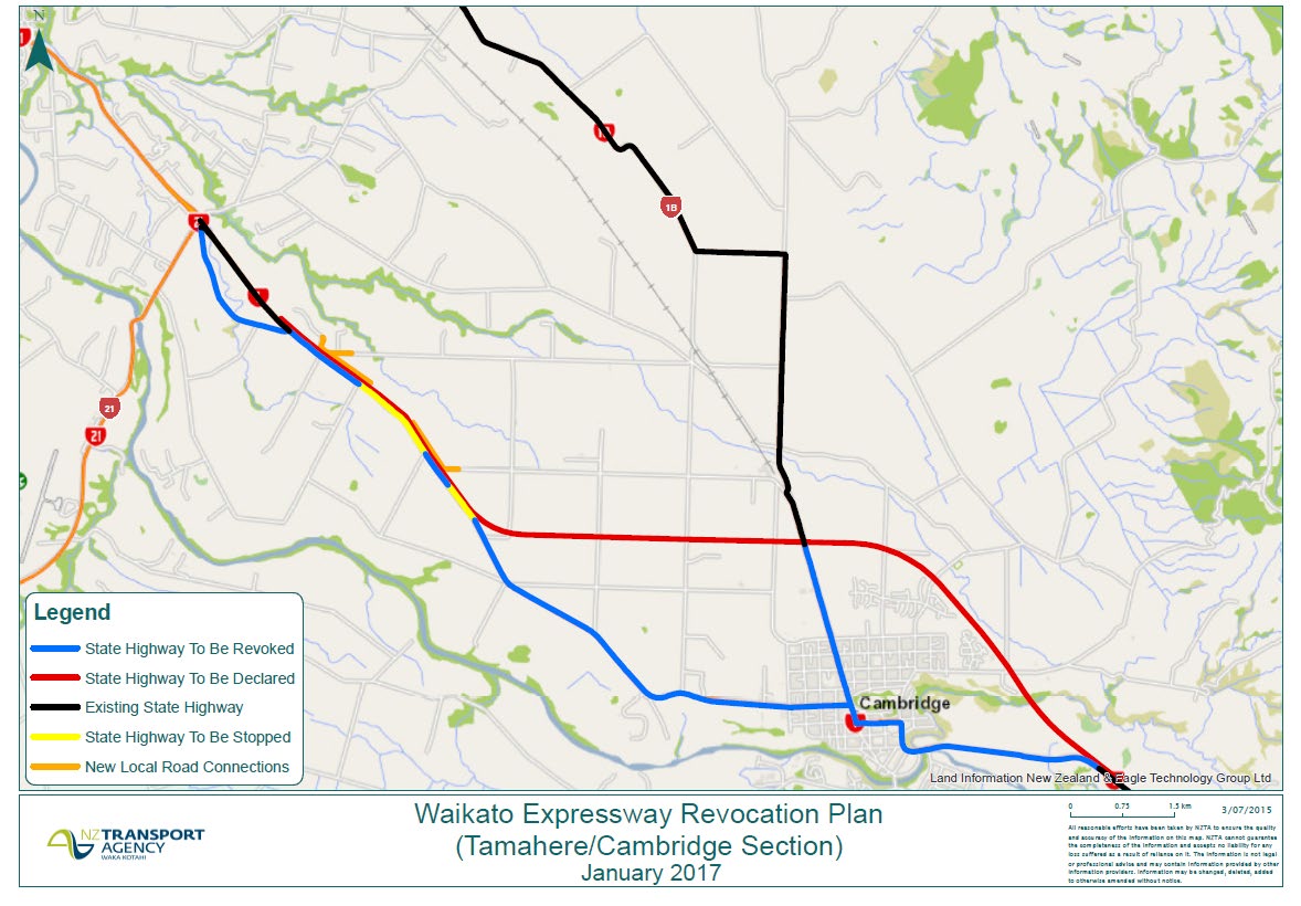
1982
APPENDIX A – Revocation Plan for Cambridge Section of Expressway
Act
Information
Official
the
under
28
Released
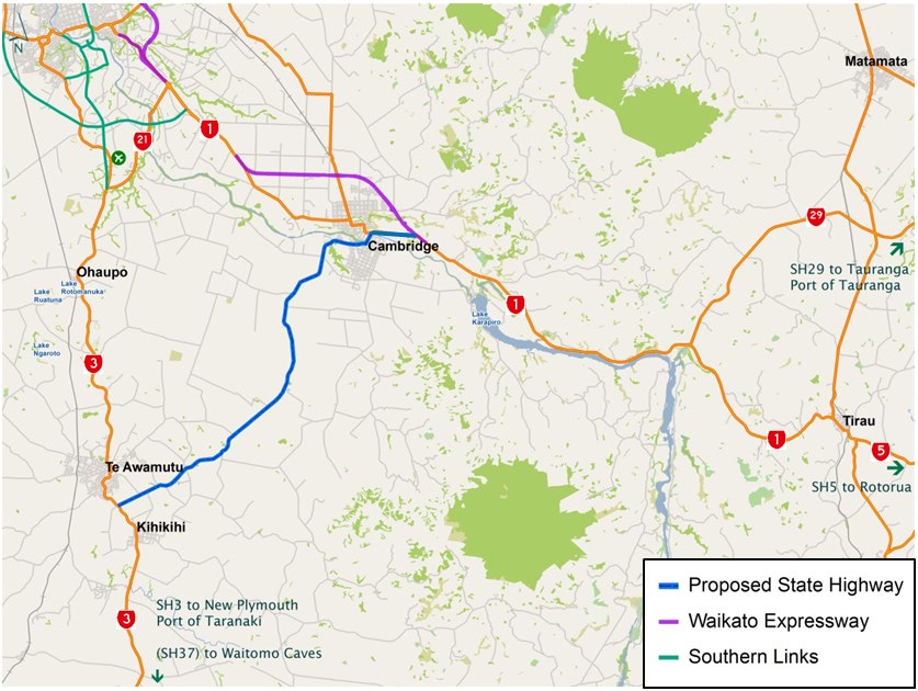
APPENDIX B – Review of case to declare a new State Highway between
Cambridge and Te Awamutu
Background
Waipa District Council raised a request with the NZ Transport Agency to consider declaring a new
state highway between Cambridge and Te Awamutu in July 2014. The proposed new state highway
would be declared along the following route, which is highlighted on the plan below:
• Tirau Road (current route of State Highway 1, identified for revocation upon opening of the
Cambridge Section of the Waikato Expressway)
1982
• Shakespeare Street / Cook Street / Pope Terrace through Cambridge
• Cambridge Road, between Cambridge and Te Awamutu
• Golf Road, Te Awamutu (connecting with State Highway 3)
Act
Information
Official
the
Regional Context
The proposed new state highway route would form a link between State Highways 1 and 3,
creating an east to south-west state highway axis between the Waikato and Taranaki Regions. State
under
Highways 1 and 3 in turn enable onward state highway connections to the Port of Tauranga,
Rotorua and Waitomo Caves.
The plan above illustrates the geographical context of the proposed new state highway route. This
includes the Waikato Expressway and the planned alignment of Hamilton Southern Links, which as
major state highway improvement projects, would serve to reinforce the strategic linkages
provided by State Highways 1, 3 and 21.
The route would link Cambridge and Te Awamutu, which as the two largest population centres in
the District of Waipa have respective populations of 17,700 and 10,300, according to the 2013
National Census.
Released
Strategic functions considered consistent with state highway status
In accordance with the distinguishing functions of state highways, as recognised in the Transport
Agency’s national State Highway Strategy, the following are examples of strategic functions, which
would be considered consistent with this route fulfilling the role of a state highway:
29
• Significant inter-regional traffic movements between Taranaki, Waikato and Bay of Plenty
regions
• Freight traffic accessing the Port of Tauranga and / or the Port of Taranaki
• Significant tourist traffic accessing Waitomo Caves and / or Rotorua
NZ Transport Agency review of case
Evidence has been reviewed from origin-destination survey data analysis supplied by Waipa District
Council, based on 2006 roadside interviews undertaken for the Waikato Regional Transport Model
(WRTM). This has been validated against up-to-date traffic count data on the route.
1982
Based on the review of evidence, the NZ Transport Agency makes the following key cinclusions and
observations:
Act
• The evidence available indicates that current and forecast usage of the route is for local trips
only, predominantly within and between the townships of Cambridge / Leamington and Te
Awamutu / Kihikihi, confirming
intra-regional use, rather than
inter-regional use.
• Whereas there could be some usage of this route by inter-regional traffic movements,
including some heavy commercial vehicle traffic, this is not considered to be to significant
enough to justify state highway status, based on overall traffic volumes.
• Current traffic data available for the proposed state highway route shows usage by both all
vehicular traffic and heavy commercial vehicles to be significantly less than that on State
Highways 1 and 3, and generally less than that on State Highway 21. This reaffirms that the
existing state highways remain the preferred strategic routes for long-distance traffic.
Comparison of traffic volumes
Information
Proposed new SH route
SH21
SH3
SH1
3,500 vpd
5,400 vpd
11,200 vpd
18,700 vpd
(10% HCVs)
(7% HCVs)
(6% HCVs)
(10%HCVs)
• The proposed state highway route would be regarded as fulfilling a duplicate strategic function
to that already enabled by the current east-west linkage of State Highways 1 / 21 / 3. It would
also undermine current investment in the Waikato Expressway and potential future investment
Official
in Hamilton Southern Links, both of which would serve to reinforce the strategic east-west
function for which the proposed new state highway would cater.
the
Next Steps
Evidence submitted by Waipa District Council for making the case includes origin-destination
survey data which dates back to 2006, which may affect the accuracy of the forecast future traffic
flows on the proposed state highway route. Any future case for declaring this route state highway
would need to be based on a robust evidence base, including up-to-date origin-destination survey
data and traffic volume data, including heavy vehicle numbers.
under
The evidence base would be required to demonstrate the following:
• That the route’s predominant traffic functions, following the opening of the Waikato
Expressway, comprise one or more of the ‘
Strategic functions considered consistent with state
highway status’ identified above.
• That the route would not duplicate a strategic function, which would otherwise be fulfilled by
State Highways 1, 21 and 3, upon completion of both the Waikato Expressway and Southern
Links.
Released
30
1982
Act
Information
Official
the
under
Released
31
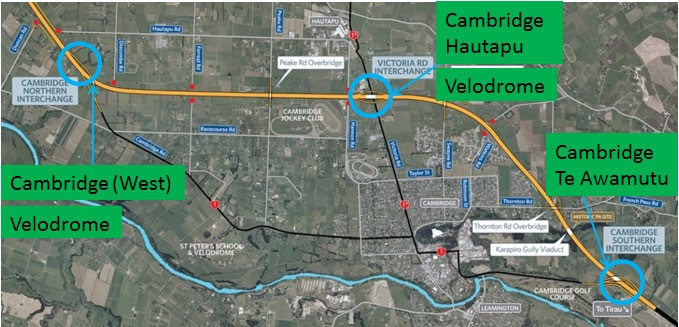
1982
APPENDIX C – Expressway Direction Signage to support Desired Future Function
Act
Information
Official
the
under
32
Released