Waipa & Waikato District Councils s42A Report
Appendix 12-
Waikato Expressway – Cambridge Section
Option Assessment Summary Document
Released under the Official Information Act 1982
239
Waikato Expressway – Cambridge Section
Option Assessment Summary Document
1
Options
1.1 Introduction
This Report briefly describes the alternatives considered during the investigation phases of
the Cambridge Section of the Waikato Expressway.
1.2 Previous Investigations
1982
The Project has a long history and an extensive record of alternatives being considered. The
alternatives have investigated improvements along the existing SH1 corridor, alternative
routes within the Cambridge Township (internal routes), and a range of new route alignments
Act
external to Cambridge Township. All of these investigations have confirmed that the
designated external route (as described in the Waipa DC District Plan) as being the preferred
option.
As such, the option selection process undertaken for this Project only consider the
alternatives relating to the current designation, and the suitability of the extent of the existing
designation. The purpose of these investigations is to identify if any further alteration to the
existing designation, based on the current needs for the Project.
1.3 Do Minimum
Information
The Do Minimum option (for the purposes of option comparison) provides no improvements
to the existing designated corridor.
In general, the existing designation width is approximately 40m wide and was intended to
provide a single lane in each direction.
Official
In order for the Cambridge Section to meet its Projects Objectives, the designated width
needs to cater for a four-lane Expressway corridor and to be consistent with the
requirements of the RoNS Standards. The desirable RoNS cross-section requires a width no
the
less than 52m. The required cross-sectional width increases if the corridor is within areas of
cut or fill or if additional features are required, such as noise or visual mitigation.
The existing designated width is insufficient to provide the necessary requirements for the
Project, without a substantial compromise in the level of service and degree of safety
under
provided by the Project. As such, the option for using the existing designation width without
alteration is not considered a viable option.
1.4 Project Options
In order to meet the Project Objectives, an alteration to the existing designation width is
needed for the Cambridge Section.
The consideration of options for the Project has therefore been undertaken for the following
Released
key items:
•
Road geometry requirements (RoNS Standards)
•
Location of altered designation
261647.00
July 2010
1
240
Waikato Expressway – Cambridge Section
Option Assessment Summary Document
•
Connection Locations and Form:
−
Northern Interchange
−
Central Interchange
−
Southern Interchange
1982
•
Karapiro Stream Gully crossing
•
Vertical design
Act
•
Pa site options
•
Localised design features
1.4.1 Evaluation Criteria
In many cases there is an indistinguishable difference between options in consideration
of the overall effects. In these cases the optimal option has been determined by its
ability to best meet the Project objectives and its ease in being able to minimise or
mitigate the effect.
Information
In general, each option was assessed in terms of the:
−
Best practice criteria/standards/guidelines for each specialist area. Each
specialist identified the relevant criteria against which to assess the effects
−
Effects of known/highly probably changes to land use
Official
−
Ability for effects to be avoided, remedied, or mitigated in terms of meeting the
RMA requirements
the
−
The importance of the feature in terms of local, regional, national, or international
significance
−
The severity of the effect that the option has on that feature in terms of:
under
▪
How the effects vary with time including whether the effects are temporary
or permanent
▪
Whether the effects are irreversible (i.e. cannot be mitigated)
▪
Any cumulative effects (such as mitigation to address one impact having a
cumulative effect on another feature)
1.4.2 Road geometry requirements
Released
As described previously in this report, the Project is one section of the overall Waikato
Expressway and is therefore defined as a RoNS project.
261647.00
July 2010
2
241
Waikato Expressway – Cambridge Section
Option Assessment Summary Document
As part of the NZTA’s role in identifying RoNS projects, they have also developed a set
of specific design standards and guidelines to be applied to each RoNS project (known
as the RoNS Standards). The purpose of this standardisation is to provide a consistent
approach to the development of each RoNS project throughout NZ.
The RoNS standards primarily relate to design considerations affecting highway
geometry, safety consideration, bridge design, and provision for alternative transport
modes. However, the RoNS standards also consider aspects such as intersection form
1982
and spacing, pavement requirements, environmental considerations, public health,
urban design, and maintenance requirements.
The RoNS standards have set the base requirements for the geometric design of each
Act
of the options.
1.4.3 Location of altered designation
Three options were considered for widening the existing designation to accommodate
the new design along the main corridor length. These included:
−
Widening on the north side only
−
Widening on the south side only
Information
−
Combination of widening on the north and south sides
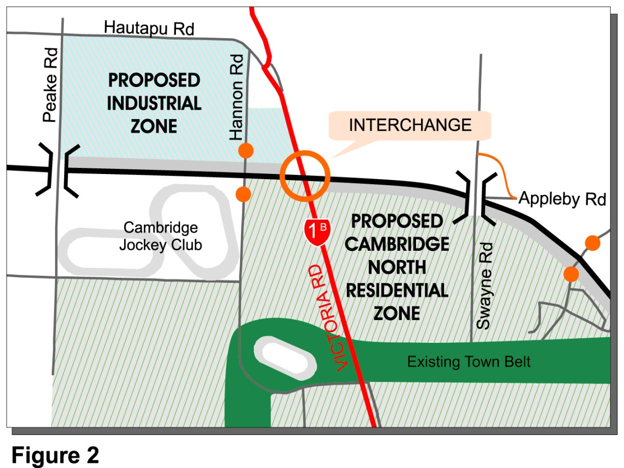
The south boundary to the current designation generally follows existing property
boundaries. As such, any widening on the southern side of the current designation
would affect additional landowners (approximately 15 additional landowners over and
above those currently affected by the designation).
Official
The existing designation has been within the Waipa District Plan for almost 40 years
and has been well established within urban development plans. As such, existing land
the
use plans already provide planned development up to the south side of the existing
designation boundary. In particular, the corridor length south of Victoria Road (SH1B)
has been extensively planned within the Cambridge North Structure Plan and
residential development south of Watkins Road already borders the designation
boundary (generally separated by a 30m wide buffer zone).
under
The Cambridge Jockey Club is a long established major land holder that borders the
southern designation boundary. Any widening of the existing designation towards the
south in the vicinity of the Cambridge Jockey Club would have a major impact on its
viability in the current location.
The northern side of the existing designation also includes a defined area of planned
future urban expansion, primarily in the form of the Hautapu Draft Structure Plan. The
Hautapu Draft Structure Plan is yet to go through a formal notification process and the
Released
specific details of the Plan are yet to be confirmed.
A relative comparison of the three locations for extending the designation boundary is
tabulated below:
261647.00
July 2010
3
242
Waikato Expressway – Cambridge Section
Option Assessment Summary Document
Criteria
Comments
Geometric Design
No specific difference on geometric requirements for
widening on either side of the existing designated corridor
Cost
Expectation for additional property costs related to acquiring
land from the southern side of the designation. Includes 1982
higher costs of residential zoned land, increased number of
landowners to complete acquisition, large number of
established residential properties (particularly south of
Watkins Road) – widening on north side of designation only
Act
preferred
Efficiency
No noticeable difference in efficiency
Safety
All three options can provide a similar level of safety
assuming the overall corridor width is equal between options
Structural
Only potential effect on structural features is the location of
the Karapiro Stream Gully crossing. Any alteration from the
existing designated route is likely to increase the crossing
Information
length and complexity by moving it further away from the
narrowest point of the gully. Preference for widening on both
sides at Karapiro Stream Gully crossing opposed to one side
only. No preference elsewhere on corridor length.
Geotechnical
Unlikely to be noticeable change in geotechnical conditions
Official
for either options. Although similarly to Structural requirement
in terms of Karapiro Stream Gully crossing.
the
Noise
Preference to develop corridor further away from residential
establishment. Clear preference for widening on the northern
side only.
Landscape
Additional separation from the residential development is
preferred. Northern widening should provide encouragement
under of establishment to the Cambridge North Structure Plan
development and buffer zone system. Important to provide
sufficient room for any landscape features.
Widening on northern boundary only preferable.
Ecology
No quantifiable difference in ecological effects
Released
261647.00
July 2010
4
243
Waikato Expressway – Cambridge Section
Option Assessment Summary Document
Criteria
Comments
Archaeology
Known archaeological features exist on both sides of corridor.
However, best preserved borrow pits (Swayne Road) occur
along southern boundary so preference for widening on north
side of designation in this location. Careful consideration of
effects at Pa site needed.
1982
General preference for widening on northern side but need
careful consideration at Pa site.
Iwi/Cultural
Safety is paramount; as is protection of any cultural features
Act
such as borrow pits and pa site. No clear preference for
widening on either side.
Water Quality
No quantifiable difference in water quality effects
Drainage
No clear preference for drainage requirements provided
sufficient width on either side of the corridor can be provided
for swale establishment.
Social Impacts
The social effects from widening on the southern side of the
Information
designation are likely to be significantly greater than those
from widening on the northern side only. This is primarily
related to the number of affected landowners, and the
substantial impact of planned and existing residential activity
south of Victoria Road.
Official
A clear preference for widening on the northern side of the
designation.
Property Impacts
Substantially greater number of affected properties if any
the
widening occurs on the southern side of existing designation.
Well established metropolitan planning already established
for Cambridge growth in place (and development underway)
on southern side. More flexibility in planned urban expansion
on northern side (Hautapu still in draft form and subject to
under change).
Clear preference for widening on the northern side of
designation.
Table 1.1: Criteria Comparison for designation widening location
There is a clear preference for widening the designation on the north side of the
existing corridor. Widening on the north side of the corridor is expected to minimise the
Released
overall effects from any alteration to designation. The exception to this relates to
specific consideration of effects on the pa site and other particular design features.
261647.00
July 2010
5
244
Waikato Expressway – Cambridge Section
Option Assessment Summary Document
Subsequent option development has been progressed with general corridor widening
occurring only on the northern side of the existing designation.
1.4.4 Connection Locations and Form Selection
The NZTA has specifically required that the designation width be sufficient to enable
the SH1 corridor to be fully grade separated along its entire Project length, with no at-
grade crossings. The exception to this is the consideration of intersections at any ramp
1982
terminations.
(a)
Northern Interchange
Act
The northern interchange has considered two options relating to access
provision:
▪
Provision for north facing ramps only (half interchange)
▪
Provision for north and south facing ramps
Traffic modelling was undertaken to determine the relative demands for each of
the two ramp arrangements. The assessment determined that there was no
reported demand for the south facing ramps at this location during any of the
Information
modelled periods. This included assessment for projected land use development
beyond the project horizon. As such, only north facing ramps have been included
in subsequent Project development.
Provision for north facing ramps only limits the grade separation options to
provide either SH1 elevated over the southbound ramp (to Cambridge), or the
southbound ramp (to Cambridge) elevated. Ground water and drainage issues
Official
prevent any of the options from being beneath ground level.
A comparison between having SH1 above or below the ramps identified a clear
the
preference for the southbound ramp being separated over the SH1 corridor. The
advantages of this arrangement include:
▪
Less traffic being elevated to reduce noise impacts
▪
The embankment and bridge structure are significantly smaller for this
under
arrangement and therefore more readily able to be mitigated
▪
Less cost
▪
Maintains priority alignment for SH1 corridor; this is particularly problematic
at this location where having SH1 over the ramp would create complexities
in combining vertical and horizontal alignment with a merge condition with
the northbound traffic from Cambridge
Released The preferred option for the Northern Interchange was considered to be a half
interchange with north facing ramps only, with the southbound ramp (to
Cambridge) being grade separated over SH1. This is consistent with the
Hamilton Bypass designation, which was confirmed in 2002.
261647.00
July 2010
6
245
Waikato Expressway – Cambridge Section
Option Assessment Summary Document
(b)
Central Interchange
The NZTA has agreed with Waipa DC that the Project should provide for a full
directional interchange at Victoria Road (SH1B). As such, the option selection
process at this interchange has focused on determining the optimal arrangement
to provide the full directional access. These options included:
▪
Interchange Form
1982
▪
Vertical alignment
▪
Ramp termination intersections
Act
Factors affecting the Central Interchange
A designation rail corridor (10m wide) runs parallel to the eastern boundary of
SH1B. This designation is described as the Cambridge Industrial Branch. The
railway corridor has been inactive for a considerable period and the railway
infrastructure was removed more than 10 years ago. Currently the Cambridge rail
line now stops 3.5km from Cambridge (1.5km from the Project alignment) and
operates as an industrial branch line to Hautapu Dairy Factory. Refer to
Figure
7.1 below.
Information
RAILWAY CORRIDOR
Official
the
under
Figure 1.1: Railway corridor
Released Extensive consultation has been undertaken with ONTRACK to establish their
long term aspirations for the railway designation. ONTRACK has provided a
consistent position that:
261647.00
July 2010
7
246
Waikato Expressway – Cambridge Section
Option Assessment Summary Document
▪
They wish to maintain all their rights over the rail corridor and have no
plans to dispose of the corridor at this time
▪
They would be most unlikely to agree to any “at-grade” crossing of the rail
corridor by any part of the Project, including on/off ramps
▪
They would be unlikely to agree to an interim at-grade crossing of the rail
corridor, whereby full grade separation would be provided if the rail was re-
1982
activated. ONTRACK advised they would not like any option that potentially
compromises the future to this rail line
However, in March 2010, ONTRACK advised that they had agreed to allow an at-
Act
grade crossing of their railway designation. This was subject to NZTA agreeing to
meet all future costs for any subsequent infrastructure needed to enable the rail
traffic to travel unimpeded through the interchange if the rail line were reinstated.
This agreement is being established within a Memorandum of Understanding
(MOU) between ONTRACK and NZTA.
The central interchange is also located in an area of extensive planned land use
development, including Cambridge North Structure Plan and the Hautapu Draft
Structure Plan. Waipa DC has indicated a strong preference for options that
minimise the amount of land lost to provide the interchange and associated
Information
ramps.
There is a growing emphasis on the urban design philosophy of “live, work, play”,
meaning there is a need to closely integrate living and employment zones to
minimise the reliance on motor vehicles and encourage the use of active
transport modes. The Waipa DC land use development plans look to promote this
Official
by identifying land use proposes for large residential areas (Cambridge North)
adjacent to large employment centres (Hautapu Industrial). SH1B (Victoria Road)
will therefore always be an important transport connection within the Waipa DC
the
network, by serving as the key link between Hautapu Draft Structure Plan and the
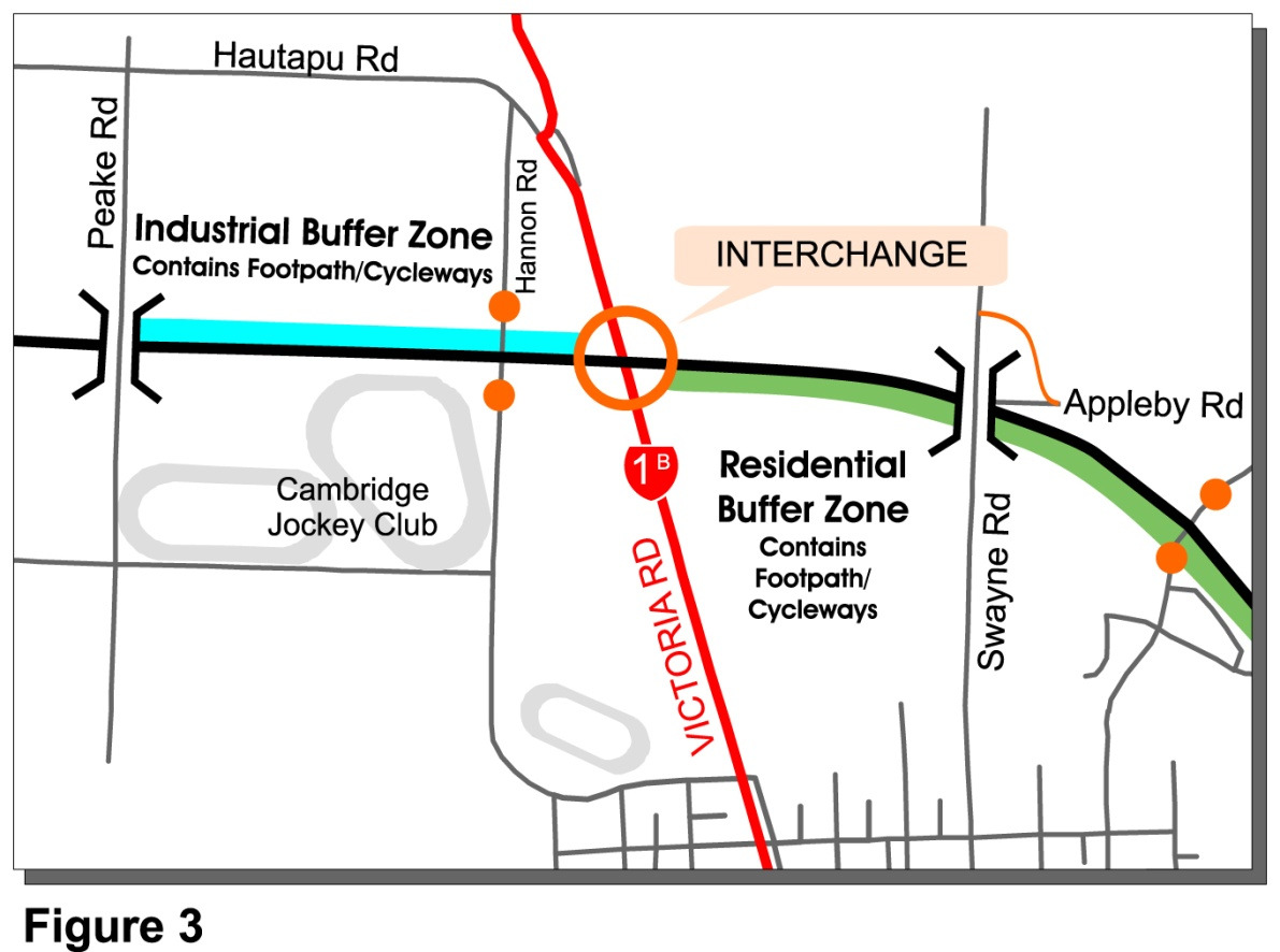
residential area of Cambridge. Waipa DC also supports this connectivity through
the establishment of “buffer zones” adjacent to the Project designation. These
buffer zones incorporate walking and cycling paths and cross the Project
alignment (from the south side to the north side of the designation) at the Central
Interchange. Refer to
Figure 7.2 below.
under
Released
261647.00
July 2010
8
247
Waikato Expressway – Cambridge Section
Option Assessment Summary Document
1982
Act
Figure 1.2: Pedestrian Cyclist Linkages Information
Geotechnical investigations have determined that the ground water levels around
the Central Interchange are variable and range between 7m below the surface to
approximately 2m below surface on the eastern approach to the interchange.
Excavation in these sandy soils would be challenging where they encounter
groundwater and it is recommended this is avoided if possible. Dewatering of any
Official
excavation would be needed during construction to prevent collapse of sand
under seepage pressures. In addition, the proximity to the groundwater levels
would necessitate the need for permanent dewatering within open cuts. Due to
the
the very flat topography and the substantial distance to any gully system (4km to
Karapiro Stream Gully) dewatering would likely require permanent pumping
stations.
Only minor settlement of embankment fills is expected and this should occur
relatively quickly and without specific treatment being required. Embankments do
under
not have any constructability or stability issues (in comparison to open cuts) and
are preferable from a geotechnical perspective. Excavation of cuts could impose
significant geotechnical risks with regard to pavement performance, cut slope
stability, environmental effects from lowering water tables and the long term
drainage needs of the cut.
(i)
Interchange Form:
Early traffic analysis determined that the need for continual movement
Released ramps was not warranted at this location. As such, all interchange options
included ramp terminations at SH1B.
Two interchange options were considered:
261647.00
July 2010
9
248
Waikato Expressway – Cambridge Section
Option Assessment Summary Document
–
Conventional “diamond” layout
–
Half clover leaf (or “Parclo”) arrangement
North
RAB
OR
OTHER
INTERSECTION
1982
TREATMENT
Hamilton
Tirau Act
RAB
OR
OTHER
INTERSECTION
TREATMENT
RAIL CORRIDOR
Information
Figure 1.3: Conventional “diamond” layout
Official
RAB
OR
OTHER
North
INTERSECTION
TREATMENT
the
RAIL CORRIDOR
Hamilton
Tirau
under
RAB
OR
OTHER
INTERSECTION
TREATMENT
Released
Figure 1.4: Parclo arrangement
261647.00
July 2010
10
249
Waikato Expressway – Cambridge Section
Option Assessment Summary Document
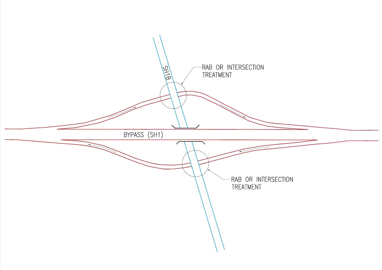
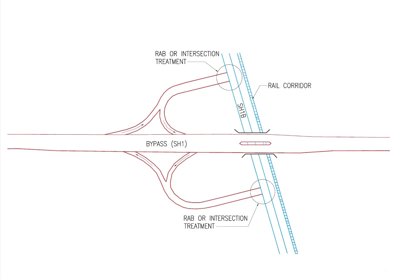
The conventional diamond layout requires the east facing ramps to cross
the railway corridor either at-grade (if SH1B remained at ground level) or on
bridges (if SH1B were elevated). The parclo arrangement avoids the need
for the ramps to cross the railway corridor as it has a loop arrangement that
locates both west and east facing ramps on the western side of the
interchange.
Table 1.2 below provides a summary of the option comparison for the
1982
preferred interchange form.
Criteria
Comments
Act
Geometric Design
The Parclo arrangement is less desirable, with the
northbound off-ramp visibility being affected by any bridge
structure (SH1 or SH1B). From a design perspective the
diamond layout is preferable. It is also consistent with other
interchanges on the Waikato Expressway.
Cost
The Parclo arrangement was estimated to cost approximately
$1.1M more than the diamond layout (ignoring land costs).
Efficiency
The Parclo arrangement is marginally less efficient than the
Information
diamond layout due to the relative difference in conflicting
movements and the increased travel distance for travel on the
south facing ramps. From an efficiency perspective the
diamond arrangement is preferred.
Safety
The Parclo arrangement is less traditional and has associated
Official
safety features that make the arrangement less safe than a
traditional diamond layout. The diamond layout is preferred.
the
Structural
Bridging arrangement will be similar between the options,
although some additional bridge widening may be needed for
the Parclo arrangement to counter the visibility problem for
the northbound off-ramp. No clear preference.
Geotechnical
No quantifiable difference between interchange forms.
under
Noise
No quantifiable difference between interchange forms.
Landscape
No quantifiable difference between interchange forms.
Ecology
No quantifiable difference between interchange forms.
Archaeology
No quantifiable difference between interchange forms.
Released
Iwi/Cultural
Safety is considered paramount by iwi; therefore diamond
layout likely to be preferred from this perspective. However,
no clear difference in effects between options.
261647.00
July 2010
11
250
Waikato Expressway – Cambridge Section
Option Assessment Summary Document
Criteria
Comments
Water Quality
No quantifiable difference in water quality effects
Drainage
No quantifiable difference between interchange forms.
Social Impacts
No quantifiable difference between interchange forms.
1982
Property Impacts
The Parclo arrangement has a significantly greater property
requirement than the diamond layout and affects a large area
of proposed industrial land. On this basis the diamond
arrangement is preferable from a property perspective.
Act
Rail effects
The Parclo arrangement requires no crossing of the railway
corridor. The diamond arrangement will require additional
features to re-establish priority to the railway corridor if the rail
line were re-established.
Table 1.2: Criteria Comparison for Form of Central Interchange
On the basis that ONTRACK has confirmed acceptance for interim at-grade
crossing of the railway corridor, the overall preference for interchange form
Information
is the diamond arrangement. However, this preference is subject to the
necessary interchange alterations being readily achievable to allow rail
traffic operation. Subsequent discussions with ONTRACK have confirmed
that they would be agreeable to the rail-crossings being controlled by
signalised at-grade crossings with appropriate bells and barrier arms.
Official
(ii)
Vertical alignment:
Geotechnical recommendations are that any grade separation should be
provided by embankments. As such, the option for developing interchanges
the
with one of the corridors within cut has not been considered further.
Traditionally (from a traffic perspective) it is considered beneficial for the
“main” through road to remain at-grade and the secondary road to be
separated above or below. This arrangement generally provides a better
under
“alignment profile” to the dominant movement. However, this requirement
needs to be considered in relation to all other parameters, such as effects
on other transport modes (walking/cycling/rail), urban design, cost,
landform etc.
Two options have been considered
–
SH1B over SH1 (SH1B overbridge)
Released
–
Requires SH1B to be graded onto an 8-9m high embankment
with an approximate length of 350m from either approach (this
provides the ramp terminations to be located at the top of the
261647.00
July 2010
12
251
Waikato Expressway – Cambridge Section
Option Assessment Summary Document
embankment. This embankment height is needed to maintain a
6m clearance along the SH1 corridor
–
Requires the rail corridor to be built on a large embankment if
rail reinstated. The rail embankment would be approximately
1km long on either approach to meet the necessary vertical
requirements for rail design
1982
–
The SH1B bridge over the Expressway would be approximately
78m long and approximately 16m wide. A total bridge surface
area of approximately 1,250m2. However, a separate bridge
structure would be required for the rail corridor if it were re-
Act
established.
–
Expressway ramps will need to be constructed on 8-9m high
embankments
to
intersect
with SH1B. These
ramp
embankments would be approximately 350m long in either
direction
–
Special provision is needed to connect the pedestrian and
cyclist routes up to the SH1B corridor
Information
–
The SH1B overbridge would create a 700m long severance to
frontage access and is likely to discourage walking and cycling.
–
SH1 over SH1B (SH1B underpass)
–
Requires SH1 to be graded onto an 8m high embankment with
an approximate length of 900m from either approach This
Official
embankment height is marginally lower than the alternative
SH1B embankment because SH1B can be constructed closer
to the existing ground level
the
–
The SH1 bridge over SH1B would be approximately 84m long
and comprise of two structures (for each direction) of
approximately 11.5m each. A total bridge surface area of
approximately 1,900m2. This bridge would not require any
under adjustment if the rail were reinstated.
–
Expressway ramps would be constructed at ground level
–
There are known localised flooding issues commencing
approximately 500m east of the Central Interchange. The
placement of the SH1 on an embankment in this location will be
needed to ensure the Expressway (and its infrastructure)
remain above these flood levels. This option is compatible with
Released
this arrangement.
–
Maintaining SH1B at ground level will provide a better linkage
across the Expressway by maintaining access at ground level.
261647.00
July 2010
13
252
Waikato Expressway – Cambridge Section
Option Assessment Summary Document
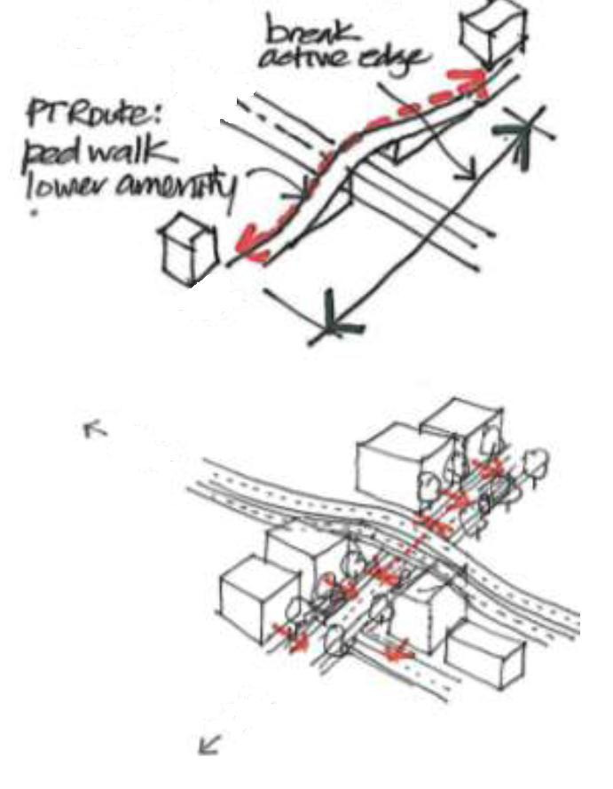
This avoids a length of “broken active edge” (refer to
Figure 7.5 below). This is particularly important for encouraging linkage by
active
modes.
In
addition,
this
arrangement
allows
intensification of landuse adjacent to Victoria Road, which
supports active transport modes. It is also likely to be more
amenable to creating a welcoming corridor (or entrance) into
Cambridge Township along Victoria Road. This is illustrated
further in
Figure 7.5 and
Figure 7.6 below.
1982
Act
Information
Official
the
under
Figure 1.5: Accessibility at Central Interchange
Released
261647.00
July 2010
14


253
Waikato Expressway – Cambridge Section
Option Assessment Summary Document
1982
Act
Information
Official
Figure 1.6: Ability of SH1 embankment option providing better visual
connection to Victoria Road (source: Brewer Davidson Preliminary
Urban Design Report)
the
Table 1.3 below provides a summary of the option comparison for the
vertical arrangement between SH1 and SH1B.
Criteria
Comments
under
Geometric Design
No particular preference from a design perspective
Cost
The two options are likely to be similar in overall costs if the
needs for the rail corridor are included in both options. No
particular preference from an upfront cost perspective.
However, this does not take account of the need for NZTA to
maintain funds to establish the rail corridor embankment and
bridge structure at some point in the future.
Released
261647.00
July 2010
15
254
Waikato Expressway – Cambridge Section
Option Assessment Summary Document
Criteria
Comments
Efficiency
There are some marginal efficiency gains for SH1 vehicles if
SH1B is graded over the Expressway. These gains are
provided by reduced vehicle operating costs with flatter
expressway grades. However, accessibility for pedestrians
and cyclists will be significantly impacted if SH1B is located
on an embankment.
1982
Safety
The arrangement with the ramp terminations at ground level
is considered to be marginally preferable to having them
Act
constructed on embankments. The option with SH1 over
SH1b is therefore preferred.
Structural
Overall there is little difference between the two options from
a structural perspective if the needs for the rail corridor bridge
are included in the assessment. No clear preference.
Geotechnical
No quantifiable difference between arrangements.
Noise
There is likely to marginally greater noise effects with the SH1
corridor on an embankment. This is due to the elevation of
Information
the higher volume of traffic. However, the effects from noise
are likely to be easier to mitigate along the SH1 corridor.
Mitigation along a SH1B embankment would be difficult
without a significant effect on accessibility. On this basis, the
preference for noise effects is considered to be neutral.
Official
Landscape
The SH1 embankment is likely to have a greater impact on
the background landscape by forming a clearly obvious
landform change. However, it is acknowledge that even the
the
SH1B overbridge arrangement will also include some
significant embankment structures from the Expressway
ramps connecting with the elevated SH1B alignment.
Overall, there is a preference for the SH1B overbridge option.
under
Ecology
No quantifiable difference between arrangements.
Released
261647.00
July 2010
16
255
Waikato Expressway – Cambridge Section
Option Assessment Summary Document
Criteria
Comments
Urban Design
The need to consider the connectivity between landuse areas
is important and cannot be replaced if broken.
There is also a need to consider all transport modes and it is
acknowledged that any forced grade separation for
pedestrians and cyclist above ground level will create a lower 1982
amenity.
It is likely that Victoria Road will become the preferred
northern entrance into Cambridge and its corridor needs to be
Act
protected for future development.
Finally, it is seen that the SH1 embankment may be seen as
a positive way to provide a defined separation between
residential activities with Cambridge North the industrial
activities within Hautapu (creating a town edge). Buildings
within industrial areas can be up to 12m in height and these
blank rear walls are seen to be unattractive. Whilst these
walls could be screened by dense planting, although this may
create unsafe (or unsecure) walking and cycling paths along
Information
the proposed Industrial and residential buffer zones.
The SH1 embankment option is preferred.
Archaeology
No quantifiable difference between arrangements.
Official
Iwi/Cultural
No quantifiable difference between arrangements.
Water Quality
No quantifiable difference between arrangements.
the
Drainage
No quantifiable difference between arrangements.
Social Impacts
No quantifiable difference between interchange forms.
Property Impacts
There are similar property impacts with both options, although
under the SH1B embankment option requires marginally more land
overall to construct the offline embankment to avoid affect on
the rail corridor. In addition, there are increased problems
associated with maintaining access to the SH1B corridor. It is
noted that this assessment does not consider the relative
difference in forecast land values post construction.
From a property requirement perspective there is a
preference for the SH1 embankment option.
Released
261647.00
July 2010
17
256
Waikato Expressway – Cambridge Section
Option Assessment Summary Document
Criteria
Comments
Rail effects
ONTRACK have confirmed that they would not be favourable
to any arrangement that made the reinstatement of the rail
difficult or expensive. The SH1 embankment option provides
the easiest reinstatement of the rail corridor.
The SH1 embankment option is preferred.
1982
Table 1.3: Criteria Comparison for SH1 and SH1B vertical arrangement
Overall, the option that places SH1 on an embankment over SH1B was
Act
determined to be the preferred option.
(iii) Ramp termination intersections:
Although the precise form of the intersections may be re-engineered during
the detailed design phase of this Project, the following provides a summary
of the option selection process undertaken to determine the best practical
option.
Three intersection forms were investigated, including:
Information
–
Priority controlled
–
Roundabouts (RAB’s)
–
Traffic Signals
Official
The priority controlled “Give Way” intersections were deemed inappropriate
because they would not provide sufficient capacity during peak periods. As
such, they were not considered further.
the
Only the traffic and urban design specialists determined a particular
preference for either of the two intersection forms.
Traffic
under
Both the RAB and traffic signal layouts provide a similar level of service for
the traffic operation (based on delays). However, it is noted that the RAB’s
have less delay and shorter queues during the early years, whilst the traffic
signals layout provides better performance during the latter years of the
project horizon. As such, from an operational perspective the ultimate
intersection form is the traffic signalised layout. However, it is also noted that
the traffic signals layout provide additional benefit (other than efficiency) over
the RAB option because:
Released – The traffic signals can be optimised to favour any route and ensure
queuing on the off-ramps can be avoided
261647.00
July 2010
18
257
Waikato Expressway – Cambridge Section
Option Assessment Summary Document
–
The traffic signals are compatible with the ultimate arrangement
necessary if the rail corridor were reinstated (i.e. if the rail corridor
were re-established the intersection would need to be signalised to
control traffic across the live rail line). Therefore, the early adoption of
traffic signals avoids potential retrofitting costs and minimises the
overall Project cost.
–
The traffic signals layout provides an easier crossing point for
1982
pedestrians and a safer alternative for on-road cyclists when
compared to the RAB layout.
Urban Design
Act
The urban design assessment for the SH1B intersection forms is focussed
on the need for good accessibility. On this basis the traffic signalised layouts
were deemed preferable, because:
–
The traffic signals layout provided a better level of service and safer
crossing points for active modes of transport
–
This layout enhanced user choice and supports social cohesion by
providing good connectivity between land use areas and activities
Information
–
The emphasis on supporting active modes is consistent with NZ
Urban Design Protocols
In summary, the Traffic Signals layout is preferred at the intersections of the
Project ramp terminations with SH1B.
Official
(c)
Southern Interchange
Traffic modelling predictions determined a need for this interchange to be grade
the
separated, which is also consistent with the overall RoNS philosophy for the
Waikato Expressway. As such, no at-grade interchanges were considered.
The southern interchange option evaluation considered the:
▪
Provision for south facing ramps only (half interchange)
under
▪
Provision for north and south facing ramps
Traffic modelling was undertaken to determine the relative demands for each of
the two ramp arrangements. The assessment determined that there was a
negligible demand for the north facing ramps at this location during any of the
modelled periods. This included assessment for projected land use development
beyond the project horizon. The modelling recognises that:
Released ▪ The route for local trips (e.g. from Shakespeare Street to Hamilton) is
approximately 2km longer if they were to use the Southern Interchange
ramps to access the Cambridge Section when compared to the route along
the existing network through the township
261647.00
July 2010
19
258
Waikato Expressway – Cambridge Section
Option Assessment Summary Document
▪
The Project will remove approximately 50-60% of the through trips from the
existing SH1 corridor through Cambridge. As such, when the Project is
complete the route through Cambridge township becomes less congested
and therefore becomes more attractive to traffic to/from Shakespeare
Street
As such, the modelling determined that provision for north facing access at the
Southern Interchange would not result in a traffic demand that was justifiable for
1982
including the north facing ramps.
A turning count (and destination) survey was undertaken at the
SH1/Shakespeare Street intersection to determine the potential catchment of
Act
northbound HCV’s if prohibition required HCV’s to travel north through the
Southern Interchange. The survey determined that:
▪
74% of HCV’s that use the intersection are northbound. Of these
northbound HCV’s:
–
16% were local buses
–
28% carried local building supply materials
Information
–
22% were local delivery type vehicles
–
8% were refuge/recycle vehicles
▪
Overall, 50% of the northbound HCV’s were found to have a destination
within the Cambridge CBD (near Victoria Street) or within the Queen Street
industrial/commercial area. A further 25% had a destination along industrial
Official
areas of Victoria Road. Only 25% of the northbound HCV’s had a
destination north of Cambridge along SH1 or SH1B. As such, even if travel
through the township was prohibited for HCV’s after the Project was
the
constructed, only 25% of the northbound HCV’s would be attracted to the
north facing ramps
The turning count confirmed that the inclusion of north facing ramps would have
very little demand given the efficiency of the alternative route along the existing
under
SH1, even if HCV’s were prohibited from travel ing through the township. As
such, only south facing ramps have been included in subsequent Project
development.
(i)
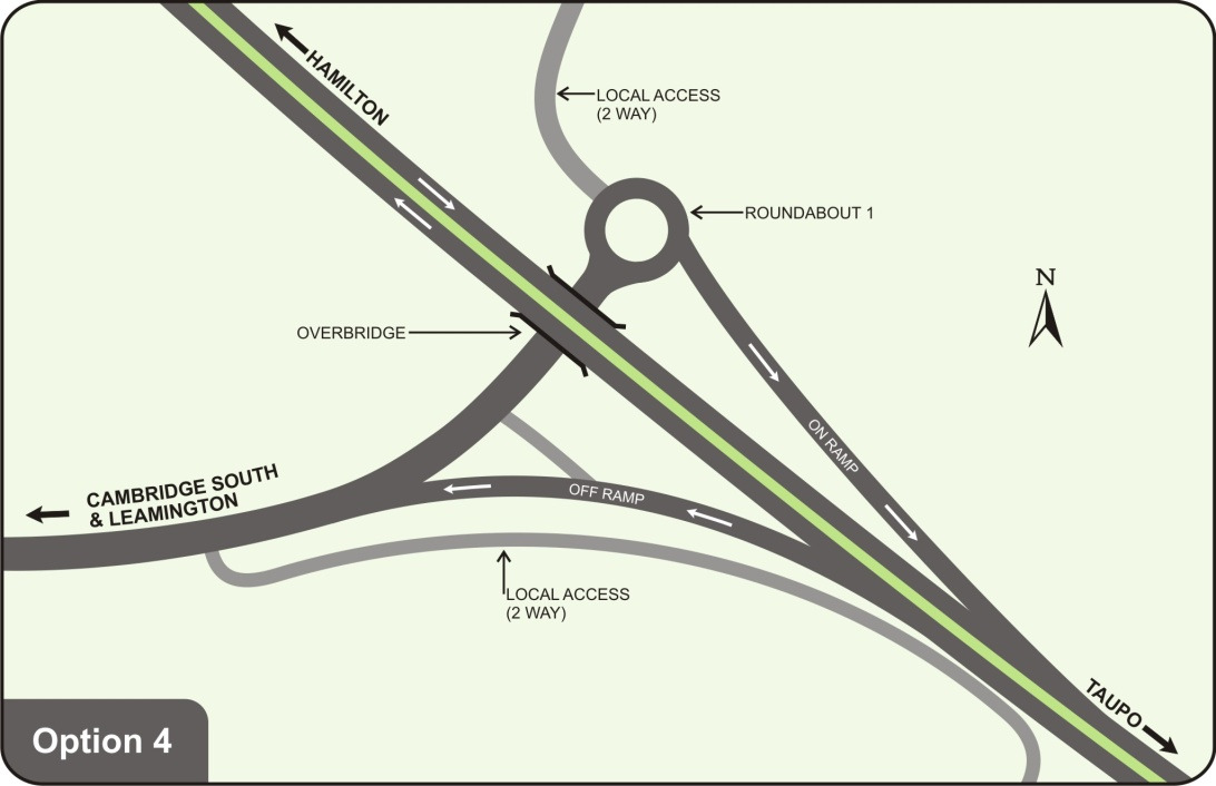
Interchange Options
A prime issue with the southern interchange relates to the need to maintain
access to adjacent properties.
Released Overall, five interchange options were considered, including:
–
Option 1: as per arrangement identified in original designation
261647.00
July 2010
20
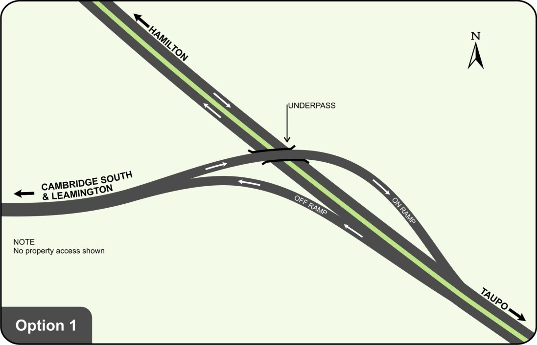
259
Waikato Expressway – Cambridge Section
Option Assessment Summary Document
1982
Act
•
Provides high speed (80km/h) south facing ramps
•
Places southbound ramp on bridge over the Expressway
Information
•
Provides no consideration of local access to adjacent properties
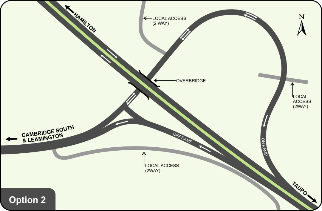
–
Option 2: Loop Road to provide combined on ramp and local access
Official
the
under
•
Southbound ramp is split part way along its length to provide two-
way directional traffic for local access and one way traffic for on-
Released
ramp function
•
Mixture of local traffic and Expressway traffic is not ideal at an
interchange location
261647.00
July 2010
21
260
Waikato Expressway – Cambridge Section
Option Assessment Summary Document
•
Changes in directional provision on roads is not ideal near
interchange ramps
•
Large land requirement to construction southbound ramp
•
Southbound ramp has a low speed design of 60km/h
•
Approximately $1.5M more expensive than option 1
1982
–
Option 3: Two roundabout configuration to connect local traffic to
roundabouts
Act
Information
Official
•
The dual RAB’s minimise the property footprint imposed by
Option 2, but maintains access to adjacent properties through the
the
RAB’s
•
The RAB’s provide a good speed threshold to manage the speed
differentials between the local traffic and the Expressway traffic
under • The RAB’s would impose a significant delay and additional
operating cost to the dominant through movement that don’t wish
to access the adjacent properties. Therefore this option is
significantly less efficient when compared to the other free-flowing
options
•
The RAB’s add a significant cost to the Project. Overall this option
is approximately $3.8M greater than Option 1
Released –
Option 4: Utilising a single roundabout for local connections to the
north and separate access way for properties to the south
261647.00
July 2010
22
261
Waikato Expressway – Cambridge Section
Option Assessment Summary Document
1982
Act
•
Similar benefits as Option 3, but requires only one RAB to be
constructed
•
Similar effect on operational efficiency as Option 3 (but lesser)
Information
•
Approximately $1.8M more expensive than Option1
–
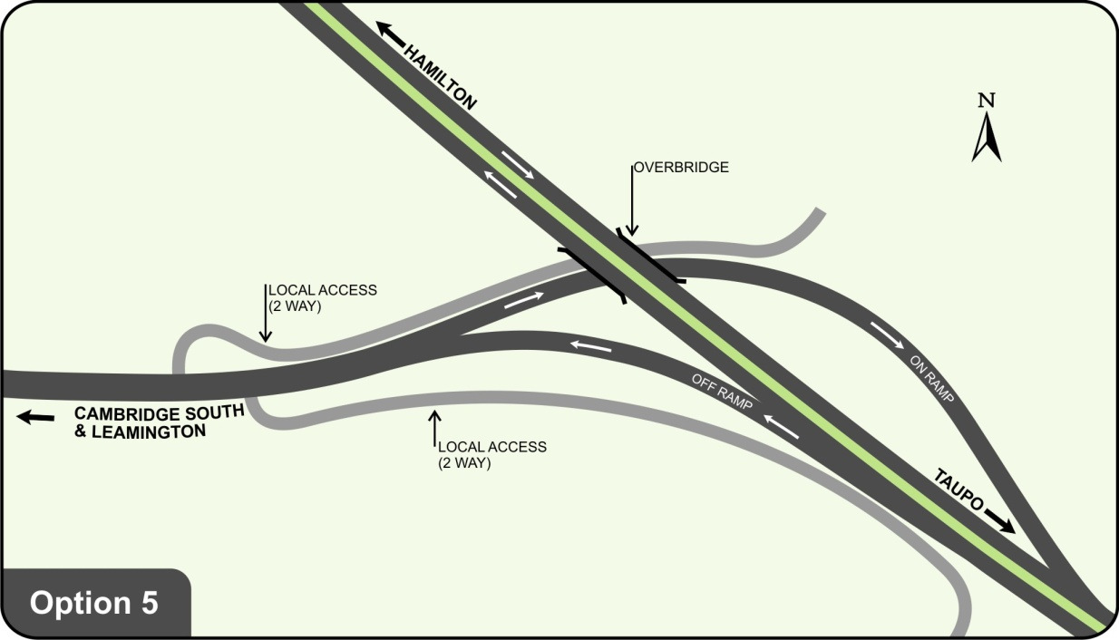
Option 5: Separation of local traffic from high speed on-off access to
expressway, providing a separate access road adjoining Tirau Road
further west for the properties to the north. Similar to option 1 except
Official
the southbound ramp passes beneath the expressway
the
under
Released
•
Similar efficiency to Option 1 and provides a free-flowing
operation
261647.00
July 2010
23
262
Waikato Expressway – Cambridge Section
Option Assessment Summary Document
•
Includes provision for adjacent property access through
development of parallel local service roads alongside ramps
•
Lengthens the overpass to allow an additional width for the
parallel local road
•
Additional construction cost over Option 1 of approximately $1.5M
1982
Options 2, 3, and 4 were primarily developed to al ow north facing ramps to
be constructed without significant construction effort. However, these
arrangements imposed significant cost and negligible demand for the north
facing ramps makes the additional costs unjustifiable, particularly because
Act
of the reduced efficiencies imposed on the southbound traffic (regardless if
north facing ramps were ever constructed).
Overall Option 5 (high speed ramps with separate local road access) was
deemed to be preferable for the Southern Interchange arrangement as it:
–
Provided good access for both local traffic and Expressway traffic,
without compromising safety
–
Provides an efficient option for all traffic movements for the long term
Information
–
Minimises the land requirement for the interchange footprint
–
Has minimal additional cost to provide for the long term access
requirements for adjacent properties
(d)
Local Road connection Official
To enable the Project to be developed consistently with the Project Objectives,
the corridor provides no direct connection with any local roads. This arrangement
the
is consistent with the current designation arrangements. As such, all local roads
that cross the existing designation need to be severed or grade separated from
the Project.
Long term plans for local road connectivity have been developed over a long
period with collaboration between NZTA and Waipa DC. The decision for which
under
roads remain open and which are to be closed has been determined by Waipa
DC. As such, no option evaluation for the local road connectivity has been
undertaken by the NZTA.
The options for grade separation arrangements between the local road and the
Project are limited to above ground options only. Geotechnical investigations
have determined a high risk associated with constructing corridors below ground
level, primarily associated with the risk of ground water flows and a lack of
Released opportunity to drain water from the cut areas.
261647.00
July 2010
24
263
Waikato Expressway – Cambridge Section
Option Assessment Summary Document
1.4.5 Karapiro Stream Gully Crossing
The Karapiro Stream has formed a large and impressive gully and it is by far the most
substantial natural physical feature encountered by the Project, which for the most part
passes through a flat, highly altered landscape.
The two principal options for crossing the gully are:
1982
−
Bridge structure, consisting of tall piers with medium to long spans.
−
Embankment fill requiring large diameter culverts within the embankment to carry
the stream flow. This option also has a sub-option of using reinforcement within
Act
the fill, mechanically stabilised earth (MSE) to steepen the embankment side
slopes and thus decrease the quantity of fill and length of culverts.
A comprehensive option evaluation was undertaken for the two crossing options. The
following provides a brief summary of the evaluation comparison.
Bridge
Embankment
Cost
Lowest
cost,
even
with Highest cost (Approximately $11M
highest bridge construction greater than the bridge option). The
cost rates.
MSE sub-option is approximately
Information
$8M greater than the bridge option
Technical
Technical and design issues Technical and design issues to be
feasibility
to be resolved with respect to resolved
with
foundation
gully side slope stability improvement and the MSE sub-
works
option
Official
Risk
Risks associated with gully High
construction
risk
from
slope stability, pile foundation unforeseen settlements, instability,
depths
and
access
for flooding during construction
the
construction
Potential
environmental
damage
risks are higher than the bridge
option
Constructability
Construction techniques well Significant issues to be resolved for
under
developed for bridge gully fill transport to base of gully and
crossings
management of stream flows during
construction
Waterway
No significant affect
Considerable likely impact
Released
261647.00
July 2010
25
264
Waikato Expressway – Cambridge Section
Option Assessment Summary Document
Bridge
Embankment
Ecological
Effects can be minimised and Major effect on gully system
gully enhanced in the long Loss of potential gully walkway
term
system
Significant
vegetation
clearing of gully side slopes
in the vicinity of the bridge
required to enable stability
1982
works
Table 7.4: Karapiro Stream Gully Crossing Option Evaluation
Act
Ngaiti Koroki Kahukura and Ngaiti Haua (as mana whenua for the Project area) have
indicated to the Project team that they have a clear preference for the bridge option.
This is because they have particular concerns relating to potential greater adverse
effects on the gully system with the culvert option.
The bridge solution for crossing the Karapiro Stream Gully is favoured on almost all
grounds over the embankment option(s) and provides the lowest cost solution.
Therefore the bridge option is the preferred option.
1.4.6 Vertical alignment design
Information
The options for considering the vertical alignment of the corridor are very limited. Key
limitation relate to:
−
The requirement to treat and discharge stormwater to appropriate watercourses
Official
−
The flat terrain which makes it difficult to grade stormwater to suitable outlets
(minimum vertical grades needed to convey stormwater)
the
−
The limited number of suitable stormwater discharge points
−
The relatively high ground water level
−
The close proximity to established residential areas
under
−
Known ground surface flood levels adjacent to the corridor
In general, it is recognised that many of the adverse effects associated with a road
corridor can be minimised by placing the alignment below ground level. However, this
arrangement is not possible except on the approaches to the Karapiro Stream Gully,
whereby the gully provides a potential location for stormwater disposal.
As such, comparable vertical alignment options were not considered as part of this
Project. Instead the vertical alignment has been optimised by identifying key design
Released
constraints that prevent further lowering of the corridor. These constraints include:
−
Maintaining a 0.3% vertical grade towards the Karapiro Stream Gully to ensure
positive flow to the stormwater outlet
261647.00
July 2010
26
265
Waikato Expressway – Cambridge Section
Option Assessment Summary Document
−
Provision of a minimum acceptable free-board above the 1-in-100 year flood level
at Watkins Road
−
Limiting practical cut heights to 8m in depth to limits effects on adjacent
properties, minimise ground water intrusion flows, and limit the need for use of
retaining wall systems
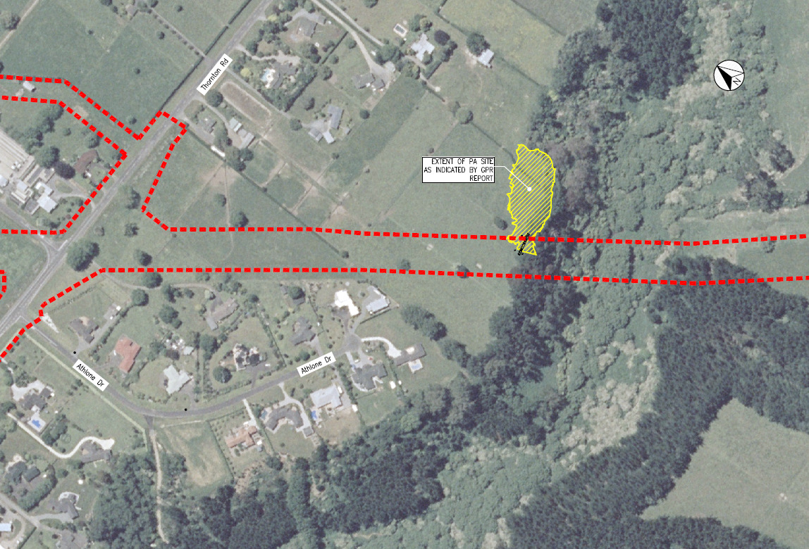
1.4.7 Pa site options
1982
The presence of the Pa site adjacent to the Karapiro Stream Gully was firstly identified
during an archaeological walkover assessment. Subsequent investigations of the site
were undertaken:
Act
−
a non-intrusive survey, using
Ground Penetrating Radar was carried out around
in and around the identified pa site and the borrow pits
−
a topographical ground survey of the observed archaeological sites to accurately
map these archaeological features in relation to the designated road corridor
The extent of the pa site was found to intrude at least 15m into the existing (40m width)
designation, with most of the apparent extents of the pa being located to the north of
the Project alignment. Hence it was clearly apparent that the Project could not be
Information
constructed along its current alignment without affecting the Pa site.
Official
Extent
of
pa
site
identified within GPR
investigation
the
under
Existing
designation
boundary
Released
Figure 1.7: Extent of pa site adjacent to Karapiro Gully
261647.00
July 2010
27
266
Waikato Expressway – Cambridge Section
Option Assessment Summary Document
In December 2008, mana whenua advised that they considered the pa site to be waahi
tapu and they would be opposed to any disturbance to the pa site, either partial or
complete.
Four options were considered to minimise the impacts on the Pa site, including two
horizontal realignments and two vertical realignments.
(a)
Horizontal Realignment towards the east
1982
This option involves shifting the horizontal alignment to pass to the north east of
the Pa site. This would involve a significant alignment shift (as the majority of the
pa extends to the north east of the current designation). The following provides a
Act
brief description of the option considerations:
▪
The realignment would add approximately 300m to the road corridor length.
▪
The archaeological investigations undertaken to date could not determine if
there were any additional archaeological sites that may be affected with this
realignment option.
▪
This realignment would result in the Karapiro Stream Gully crossing being
located at a much wider location. This would add at least 100m to the
Information
length of the bridge structure.
▪
Another local road bridge would be required if St Kilda Road was to remain
connected to Thornton Road.
▪
Three additional houses would need to be removed
Official
▪
The total additional cost would be approximately $10M with $6M in
additional construction and $4M in additional property costs.
the
(b)
Horizontal Realignment towards the west
This option only requires a very minor centreline shift, when combined with some
refinement to the cross-section (narrowing of the median and inclusion of
retaining walls). The following provides a brief description of the option
considerations:
under
▪
The construction footprint can be accommodated within the space between
the eastern boundary of the Athlone Drive properties and the western
extent of the pa.
▪
There is some encroachment into an existing Waipa DC buffer strip.
▪
Waipa DC have indicated that the loss of the buffer strip is acceptable if an
equivalent reserve area can be established from severed land adjacent to
Released the Karapiro Stream Gully.
▪
One additional house would need to be removed
261647.00
July 2010
28
267
Waikato Expressway – Cambridge Section
Option Assessment Summary Document
▪
The cost of this option is approximately $2M (primarily associated with the
purchase of the additional house and construction of the retaining walls)
(c)
Vertical Realignment beneath the Pa site
The Project’s preferred vertical alignment is approximately 7m below the ground
level in the vicinity of the pa site. It is likely that the remains of pa exist to a
maximum depth of 1m. Therefore, only a minor lowering of the vertical alignment
1982
would enable the corridor to be “tunnelled” underneath the pa and still maintain
appropriate vertical headroom. The following provides a brief description of the
option considerations:
Act
▪
Conventional tunnelling would not be feasible because of the shallow cover
above the tunnel (approximately 2m), the relatively short length of tunnel
being required (less than 50 metres), and the nature of the soils (SANDS).
▪
The only feasible construction option, which avoids disturbance to the Pa
remains, would involve thrusting a large “shield type structure beneath the
pa site. The shield will support the soil whilst the cavity is excavated and
supports the roof whilst the walls are constructed.
▪
The cost of this operation would be considerable and there are a number of
Information
technical challenges to avoid disturbance to the overlying soil during
construction.
▪
The overall appearance of a short tunnel section adjacent to the Karapiro
Stream Gully bridge would be unusual.
▪
Iwi have advised that this option is culturally inappropriate and they would
Official
be opposed to it.
▪
The cost of this option is approximately $5M. However, there would also be
the
large contingency risk items that would need to be included due to design
uncertainties.
(d)
Vertical Realignment over the Pa site
This option includes the construction of a bridge over the Pa site and leaving the
under
ground underneath largely undisturbed. The Project would be aligned
approximately 10m above the existing ground level. The following provides a brief
description of the option considerations:
▪
This option would cause significant adverse environmental effects
(including noise and visual), which would be difficult to mitigate.
▪
The Project’s preferred vertical alignment has the corridor in a substantial
cut. The cutting minimises the visual impact and provides excellent noise
Released mitigation for the residents adjacent to the corridor.
261647.00
July 2010
29
268
Waikato Expressway – Cambridge Section
Option Assessment Summary Document
▪
The raising of the vertical alignment would affect the Thornton Road
crossing and require Thornton Road to be lowered beneath the
Expressway, which will have consequential geometric and visibility issues.
▪
The Karapiro Stream Gully Bridge would be lengthened by approximately
40m and require the bridge piers to be lengthened by approximately 17m
(to 45m+).
1982
▪
The additional cost of this option would be at least $6M.
Act
Table 1.5 below provides a summary of the option comparison for the four options.
Horizontal Realignment
Vertical realignment
Criteria
East
West
Lower
Raise
Geometric Design
No specific
No specific
No specific
No specific
issues
issues
issues
issues
Additional Cost
$10M
$2M
$5M (plus
$6M
significant risk)
Information
Longer route
Insignificant
Some slight
Substantial
Efficiency
resulting in
change
increase in
increase in
additional
operating costs
operating costs
operating costs
due to increased
due to steeper
grades
grades
Safety
No specific
No specific
No specific
No specific
Official
issues
issues
issues
issues
Structural
Longer bridge but
Minor increased
Particular
Additional bridge
the
technically
structural
structural risk
structure for
feasible. Also
requirements
Expressway. Also
includes
complications
additional local
with Thornton
road bridge
Road crossing
under
Geotechnical
No specific
No specific
Some additional
No specific
issues
issues
risk
issues
Noise
No specific
No specific
No specific
Increased noise
change
change
change
mitigation
requirements
Landscape
No specific
No specific
No specific
Visual effects
change
change
change
more difficult to
Released
mitigate
Ecology
No specific
No specific
No specific
No specific
change
change
change
change
261647.00
July 2010
30
269
Waikato Expressway – Cambridge Section
Option Assessment Summary Document
Horizontal Realignment
Vertical realignment
Criteria
East
West
Lower
Raise
Urban Design
No specific
No specific
No specific
Vertical
change
change
change
separation of
Thornton Road
crossing is not
ideal
1982
Archaeology
Unknown risk
Likely to affect
Very risky to
Unknown risk
outer lying
archaeological
portions of the pa
site
Act
Iwi/Cultural
Avoids pa site
Avoids pa site
Culturally
Culturally
inappropriate
inappropriate
Water Quality
No specific
No specific
No specific
No specific
change
change
change
change
Drainage
No specific
No specific
No specific
No specific
change
change
change
change
Social impacts
No specific
Minor effects
No specific
Not favoured
Information
change
from alignment
change
closer to Athlone
Drive residents
Property impacts
Significant due to
Minor effect on
No change
No change
corridor being
buffer zone and
Official
very removed
one additional
from existing
property
designation.
Additional land
the
required
Table 1.5: Summary of Pa site realignment option evaluation
Overall, the option with a minor horizontal realignment towards the west was
determined to be preferred.
under
Ngaiti Koroki Kahukura and Ngaiti Haua (as mana whenua for the Project area) have
indicated to the Project team that the preferred pa site realignment option is acceptable
to them.
1.4.8 Localised design features
The stormwater design identified a need for a wetland to store and treat stormwater
collected by the Project. This is required to be located at the low point of the vertical
Released
alignment within the cut section of the Expressway (identified at Chainage 9100).
261647.00
July 2010
31
270
Waikato Expressway – Cambridge Section
Option Assessment Summary Document
Options for placing the wetland on either side of the Expressway in this location have
been considered. Both options are technically feasible and there is no preference for
locating the pond on either side of the corridor from a design perspective.
A landscape design and urban design assessment has determined a particular
preference for the wetland to be located on the west side of the Expressway. This is
considered to be preferred because:
1982
−
It will be more compatible with the 30m wide buffer zones currently identified on
the western side of the Expressway within the Waipa District Plan.
Act
−
It provides great opportunity to link the buffer zone to Thornton Road and Athlone
Drive, thereby directing the buffer corridor to the proposed reserve area adjacent
to Karapiro Stream Gully.
−
The proposed landscaping around the wetland wil provide a more useable asset
for Waipa DC.
−
The wetland will provide better separation between the residential area and the
Expressway.
−
The alternative location (wetland on the eastern side of the Expressway) does not
Information
provide any connectivity between the proposed landscaped area and any other
landscape or community feature
Placement of the wetland on the western side of the Expressway will affect one
landowner (also affected by the existing designation). Three landowners will be
affected with the wetland being located on the east side of the Expressway (two are
Official
already affected by the existing designation and the third is affected by the proposed
alteration to designation).
One of the directly affected landowners has identified a particular attachment to the
the
land bordering St Kilda Road and has a long family association with the land since
1880. They have indicated a strong preference for the wetland to be located on the
eastern side of the Expressway.
Overall, the option for locating the wetland on the western side of the Expressway has
under
been determined to be preferred.
1.5 Conclusion
In summary the option evaluation process has determined that:
•
An alteration to designation is required to accommodate the latest design requirements
•
There is a preference for the widening of the designation to generally occur on the
Released
northern side of the existing designation, except to accommodate specific design
features
261647.00
July 2010
32
271
Waikato Expressway – Cambridge Section
Option Assessment Summary Document
•
The Northern Interchange should only provide north facing ramps. The southbound
ramp should be graded vertically over the Expressway
•
The Central Interchange should be a traditional diamond layout. The Expressway
should be graded vertically over Victoria Road (SH1B). The intersection at the Central
Interchange ramp terminations should be signalised junctions.
•
The Southern Interchange should provide only south facing ramps. The layout should
1982
provide high-speed free flowing movements and provide separate local roads for
adjacent property access
•
There should not be any direct connection between the Expressway and local roads
Act
•
The Karapiro Stream Gully crossing should be a bridge
•
A minor horizontal realignment of the Expressway towards the west should be included
to minimise the effects on the Pa site. This shall also include a localised refinement of
the Expressway cross-section (including narrowing the median and incorporation of
retaining walls)
•
The Thornton Road wetland should be positioned on the west side of the Expressway
Information
Official
the
under
Released
261647.00
July 2010
33
272
1982
Act
Information
Official
the
under
Released
261647.00
July 2010
34