
 REPORT
Coastal Hazard Management
REPORT
Coastal Hazard Management
Options Assessment - Te
Rohutu Block, Waitara East
Prepared for
New Plymouth District Council
Prepared by
Tonkin & Taylor Ltd
Date
March 2023
Job Number
1001955.4000 v3
Document control
Title: Coastal Hazard Management Options Assessment - Te Rohutu Block, Waitara East
Date
Version
Description
Prepared
Reviewed
Authorised by:
by:
by:
January
1
Draft report for client
R. Haughey
T. Shand
J. Russell
2023
review
J. Clarke
8 March
2
Final draft report
R. Haughey
T. Shand
J. Russell
2023
addressing client review
J. Clarke
9 March
3
Final report
R. Haughey
T. Shand
J. Russell
2023
Distribution:
New Plymouth District Council
1 PDF copy
Tonkin & Taylor Ltd (FILE)
1 PDF copy
link to page 5 link to page 7 link to page 8 link to page 8 link to page 10 link to page 11 link to page 12 link to page 14 link to page 15 link to page 16 link to page 18 link to page 19 link to page 20 link to page 21
Table of contents
1
Introduction
1
2
Coastal hazards
3
3
Coastal management options
4
3.1
Do nothing (status quo)
4
3.2
Beach re-nourishment
6
3.3
Groynes (control structures)
7
3.4
Bund/stopbank
8
3.5
Rock revetment
10
3.6
Vertical seawall
11
3.7
Backstop wall
12
3.8
Accommodate (raise floor levels)
14
3.9
Managed retreat
15
3.10 Combination of options (adaptive management)
16
4
Summary
17
5
Applicability
20
Tonkin & Taylor Ltd
March 2023
Coastal Hazard Management Options Assessment - Te Rohutu Block, Waitara East
Job No: 1001955.4000 v3
New Plymouth District Council
Executive summary
The shoreline along Te Rohutu Block, Waitara East is affected by coastal erosion and inundation
hazards. NPDC have plans to remove the six most seaward houses within Te Rohutu Block and are
seeking to investigate options for coastal hazard management once the houses are removed, to
minimise the future exposure of assets located further landward.
Tonkin + Taylor Ltd (T+T) have been engaged by NPDC to assess a range of potential hazard
management options for reducing the impacts of coastal erosion and inundation along Te Rohutu
Block. Coastal hazard management options considered include:
•
Do nothing (status quo)
•
Beach renourishment
•
Groynes (control structures)
•
Bund/stopbank
•
Rock revetment
•
Vertical seawall
•
Backstop wall
•
Accommodate (raise floor levels)
•
Managed retreat.
The options are presented at a conceptual level with sketches and, where appropriate, photographs
of similar structures to provide clarity to the community on the appearance and visual impact of
each option. Additional information on the relative costs, design life and effectiveness of each
option are presented and are intended to form the basis for discussion with the community on
preferred options.
Due to the different coastal hazards (i.e., erosion and inundation) occurring over different temporal
and spatial scales the most suitable management option for Te Rohutu Block is likely to be a
combination of options implemented at different stages. As part of a longer-term adaptation
strategy, it may also be necessary to upgrade options or replace them with alternatives in order to
maintain an acceptable degree of protection.
Tonkin & Taylor Ltd
March 2023
Coastal Hazard Management Options Assessment - Te Rohutu Block, Waitara East
Job No: 1001955.4000 v3
New Plymouth District Council
link to page 5 link to page 6
1
1
Introduction
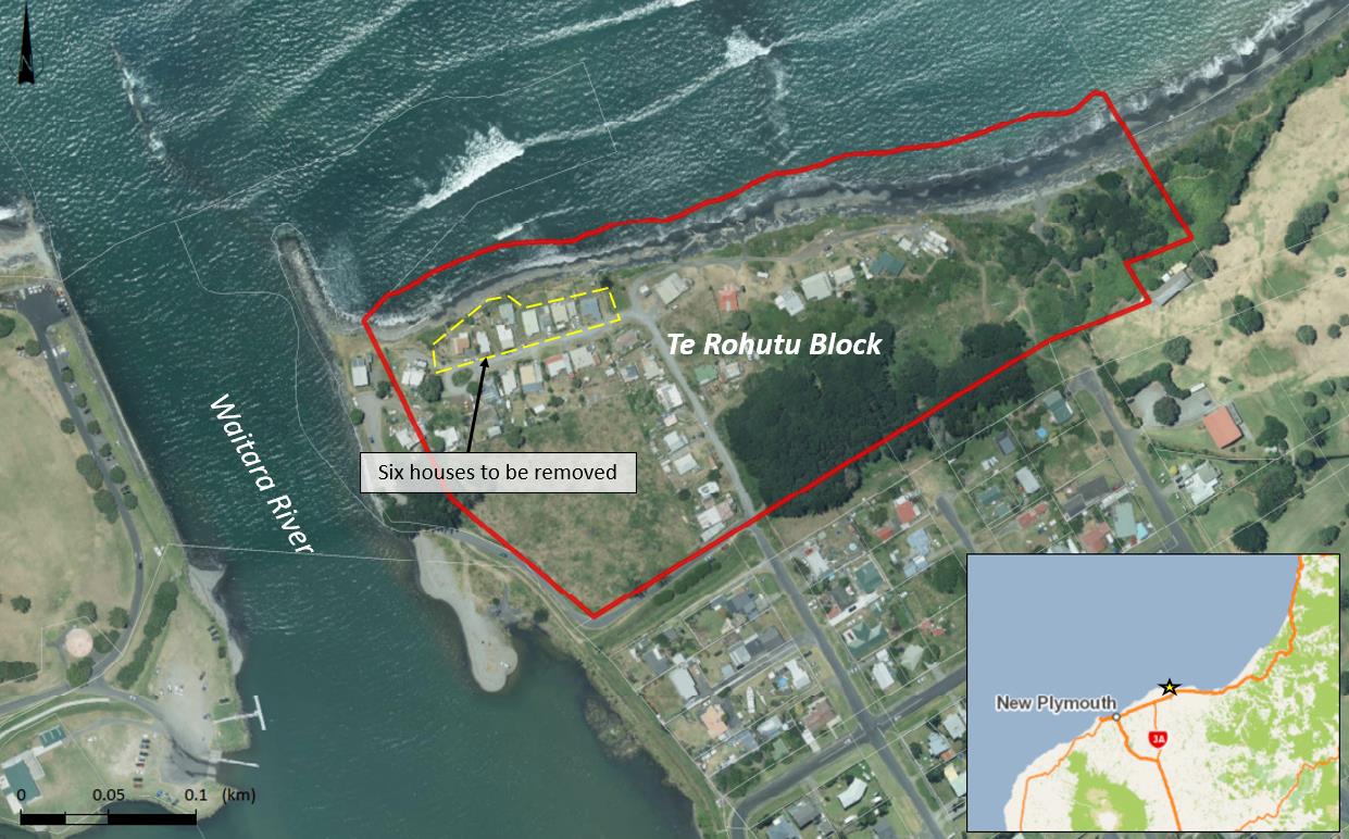
The coastline at Waitara is exposed to coastal hazards including erosion and inundation. New
Plymouth District Council (NPDC) have identified the shoreline along Te Rohutu Block, directly east
of the Waitara River mouth
(Figure 1.1 and
Figure 1.2), as being a high priority site for undertaking
coastal hazard management. We understand that NPDC plan to remove the six most seaward houses
within Te Rohutu Block (no. 15 to 20 East Beach, shown in Figure 1.1) and are seeking to investigate
appropriate coastal management options once the houses are removed, to minimise the exposure of
coastal hazards on the assets further landward, such as the access road.
Tonkin + Taylor Ltd (T+T) have been engaged by NPDC to assess the coastal management options for
Te Rohutu Block, with a particular focus on potential short-term options. T+T recently completed a
coastal hazards assessment for Waitara to identify the magnitude and extent of present-day and
future coastal erosion and inundation (T+T, 2023)1. The findings from the hazard assessment have
been used to inform the management options discussed within this report. As part of the hazard
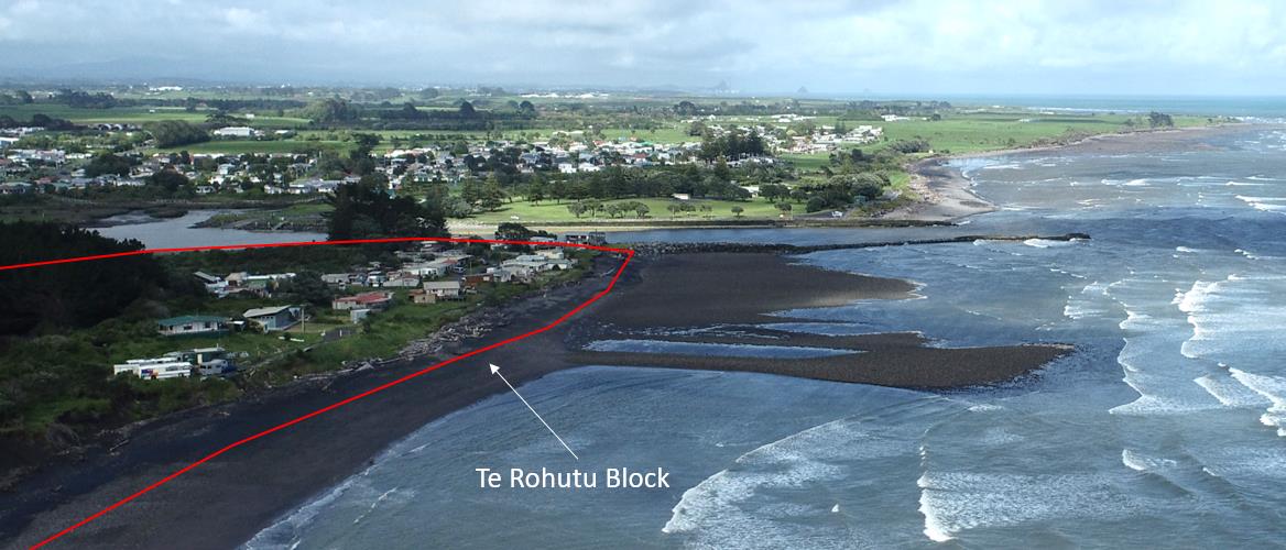
assessment a site inspection was also completed during low tide on 1 December 2022 by a T+T
coastal scientist accompanied by a NPDC council officer and member of Te Rohutu Trust.
Figure 1.1: Location and extent of the study site
1 Tonkin + Taylor Ltd (2023). Waitara Detailed Coastal Hazard Assessment. Prepared for New Plymouth District Council.
Tonkin & Taylor Ltd
March 2023
Coastal Hazard Management Options Assessment - Te Rohutu Block, Waitara East
Job No: 1001955.4000 v3
New Plymouth District Council
2
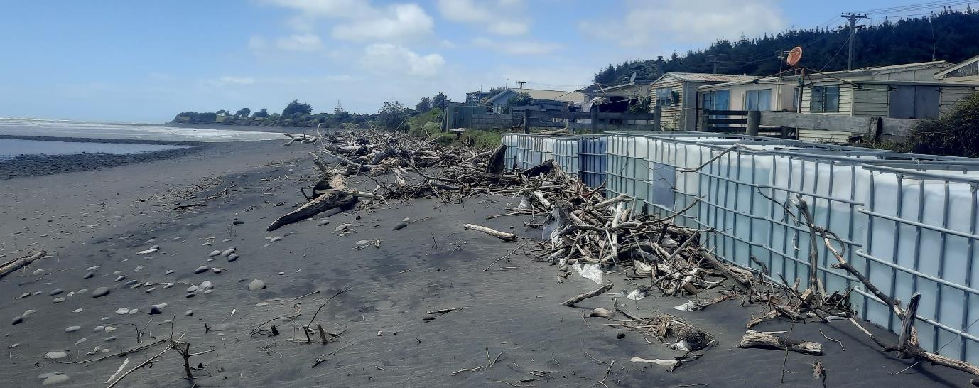
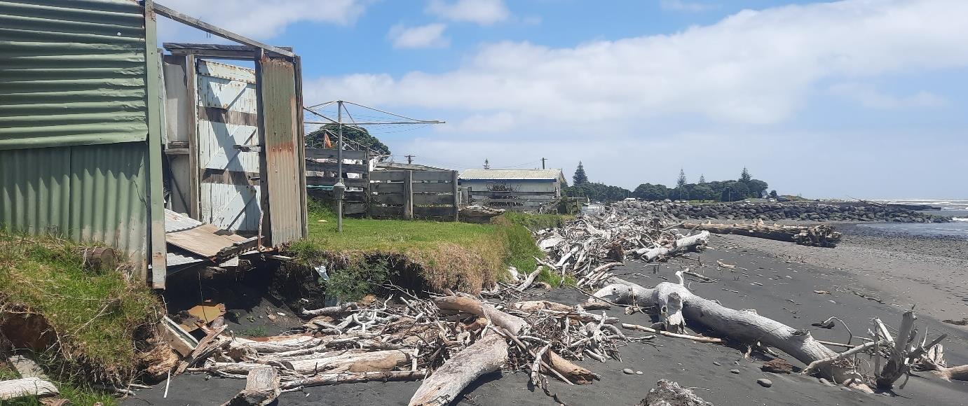
Figure 1.2: Site photos of the shoreline along Te Rohutu Block. (Top) Oblique aerial photograph taken looking
west towards Te Rohutu Block and the Waitara River mouth. (Centre) Looking east along the shoreline near no.
15 and 16 East Beach, where structures have been placed to reduce erosion and inundation from waves.
(Bottom) Looking west along the shoreline near no. 20 East Beach where the the land beneath the shed is
currently eroding.
Tonkin & Taylor Ltd
March 2023
Coastal Hazard Management Options Assessment - Te Rohutu Block, Waitara East
Job No: 1001955.4000 v3
New Plymouth District Council
link to page 7 link to page 9
3
2
Coastal hazards
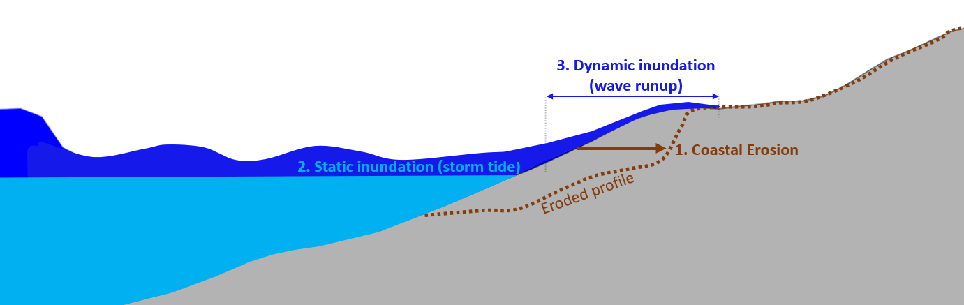
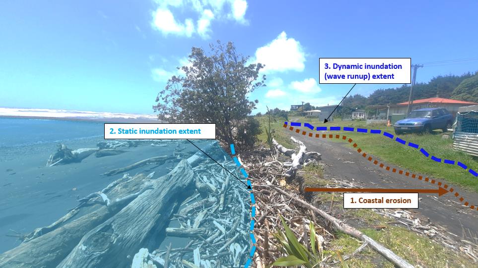
The coastal hazards that are considered along the shoreline at Te Rohutu Block are
(Figure 2.1)
coastal erosion and coastal inundation, which includes static inundation and dynamic inundation.
Coastal erosion is the loss of sediment, resulting in the shoreline position shifting landward. Static
inundation includes flooding of normally dry land due to elevated coastal water levels. Dynamic
inundation is the periodic inundation of the coastal edge as waves break and overtop the backshore
(wave runup).
Figure 2.1: (Top) Simplified schematic showing the three different hazards included within the assessment.
(Bottom) photograph of the shoreline in East Waitara with indicative mark up of the three different hazards
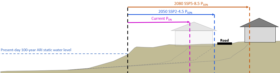
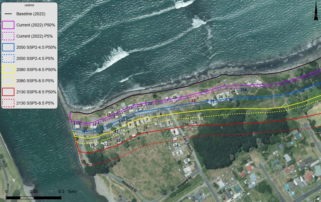
T+T (2023) includes updated coastal erosion and coastal inundation hazard assessments for the
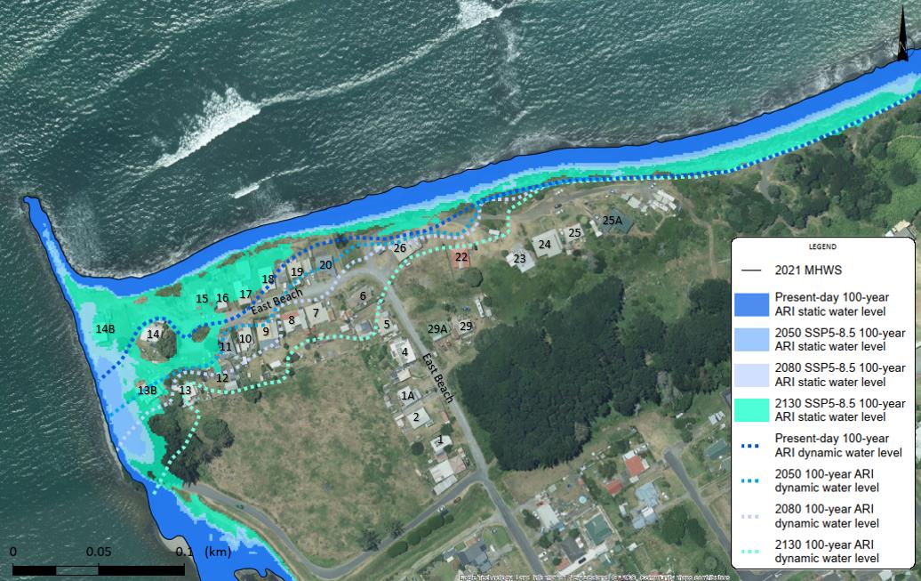
Waitara shoreline. The projected erosion and inundation hazard extents for the Te Rohutu Block
have been mapped as shown in
Figure 3.2.
The properties and road are likely to first become affected by wave runup before being exposed to
coastal erosion and static inundation (ponding or settled water) during storm tides. As the shoreline
continues to erode the magnitude and landward extent of wave runup will increase over time.
Further details on the coastal erosion and inundation hazards for Waitara can be found in T+T
(2023).
Tonkin & Taylor Ltd
March 2023
Coastal Hazard Management Options Assessment - Te Rohutu Block, Waitara East
Job No: 1001955.4000 v3
New Plymouth District Council
link to page 9 link to page 9 link to page 9 link to page 9
4
3
Coastal management options
To reduce the impacts of coastal erosion, inundation and wave run up along Te Rohutu Block,
several different management options have been investigated. An overview of the potential
management options is provided below.
3.1
Do nothing (status quo)
Description
The status quo is assumed to include removal of the six houses most at risk (no. 15 to 20 East Beach)
but no other shoreline management undertaken.
Technical considerations
The status quo is likely to require emergency response and management costs and loss of public and
private assets.
Effectiveness against erosion
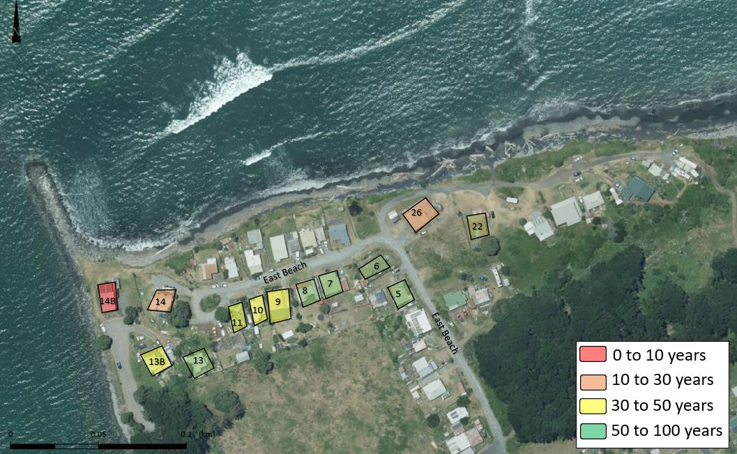
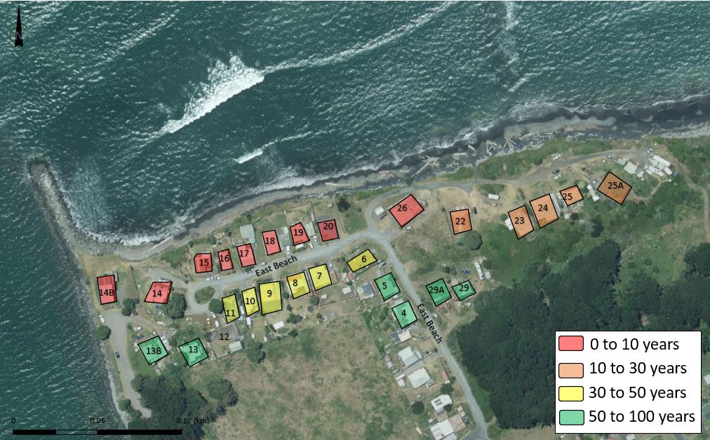
Based on the findings of our assessment undertaken to date (T+T, 2023), existing erosion processes
will continue. Removal of the six houses reduces the immediate erosion risk by removing the
threatened structures which are at risk to erosion over the next 10 years
(Figure 3.1 and
Figure 3.2).
However, irrespective of the houses being removed, the coastal erosion is likely to continue at the
rates predicted by T+T (2023).
If no shoreline management is undertaken, the findings from T+T (2023) indicate there are an
additional five houses potentially at risk to coastal erosion over the short-term (i.e. next 10 years),
including the Waitara Boardriders club (14B), no. 14, 22, 25A and no. 26 East Beach
(Figure 3.2). The
access road to no. 23 to 25A East Beach is seaward of the houses and therefore the vehicle access to
these properties will be lost before the houses become exposed to erosion.
Over the medium term (i.e. 2050 to 2080) the section of East Beach road that runs parallel to the
coast may become exposed to coastal erosion which would result in loss of access to properties no.
6 to 11 East Beach. Under a high sea level rise (“SLR”) scenario (i.e. SSP5-8.5) there is potential the
houses at no. 5 to 11 East Beach are eroded by 2080. Over the long-term (i.e. by 2130) properties
no. 4, 5, 12, 13, 13B, 29 and 29A East Beach may also become exposed to coastal erosion.
Effectiveness against inundation
Before the properties and road are lost to coastal erosion, they are likely to become exposed to
periodic flooding from wave runup during storm events. During a present-day 100-year Average
Recurrence Interval (ARI) event the static coastal water level does not exceed the crest of the
existing dune, however wave runup does have potential to exceed the crest and extend landward in
some locations
(Figure 3.2). Waves are likely to extend further landward through the lower sections
of the dune, for example along the low shoreline seaward of no. 26 East Beach and around no. 14B.
This will result in periodic flooding across the access road and eventually flooding of the houses.
The modelling shows that the 100-year ARI static water levels do not exceed the existing dune crest
level until 2130, however static inundation into Te Rohutu Block is likely to occur along the eastern
bank of the river mouth before it floods directly over the dune crest. There is also potential for the
inundation hazard to be exacerbated by erosion over time with some properties becoming exposed
sooner. Based on the 2130 erosion hazard extent, there is potential that the houses at 1 to 2 East
Beach may become exposed to periodic inundation from wave runup as the shoreline erodes,
however that is unlikely to occur until 2130.
Tonkin & Taylor Ltd
March 2023
Coastal Hazard Management Options Assessment - Te Rohutu Block, Waitara East
Job No: 1001955.4000 v3
New Plymouth District Council
5
Figure 3.1: Indicative cross-section showing the extent of current and future erosion hazard areas
Figure 3
.2: Extent of coastal erosion (top) and coastal inundation (bottom) hazards along Te Rohutu Block
Tonkin & Taylor Ltd
March 2023
Coastal Hazard Management Options Assessment - Te Rohutu Block, Waitara East
Job No: 1001955.4000 v3
New Plymouth District Council
link to page 10 link to page 11
6
3.2
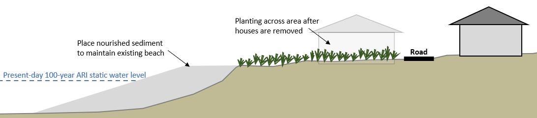
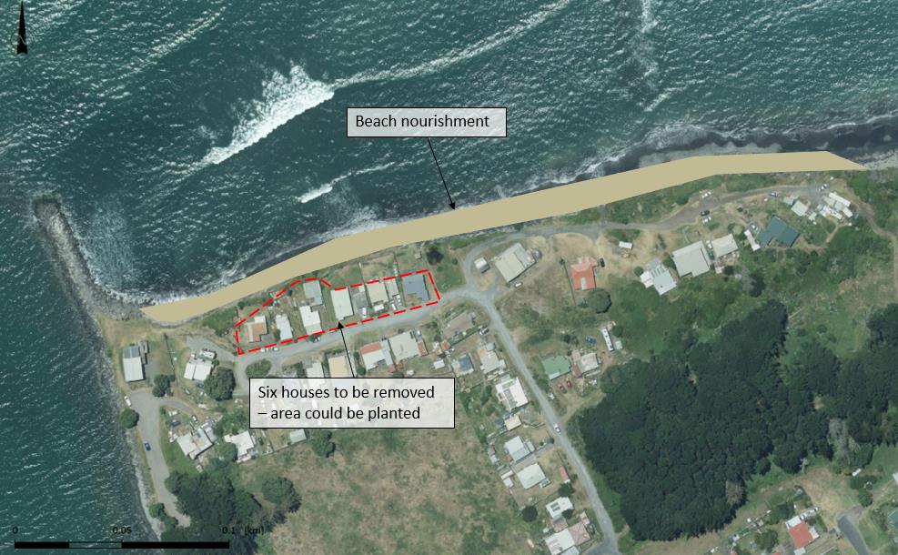
Beach re-nourishment
Description
Beach re-nourishment involves placing an increased volume of sand on the beach, thereby
increasing the capacity of the beach system to absorb wave energy and reducing the amount of
wave energy reaching the foredune
(Figure 3.3 and
Figure 3.4). Beach nourishment can either aim to
replace material lost through erosion or create a larger beach that provides an increase standard of
protection against erosion.
This option, and the following options, could incorporate planting of native species across the land
where the houses have been removed. Planting can help to trap windblown sand, building a dune to
provide a sand buffer before the sand is lost inland. However, as erosion progresses, any vegetation
on the seaward face of the erosion scarp may be lost.
Technical considerations
Initially a nourished beach profile would need to be placed with approximately 5 to 10,000 m3 of
sediment, depending on the desired width and length of nourishment. Based on a long-term erosion
rate of -0.6 m/year the yearly average volume of sediment required to maintain the existing beach
volume along the 350 m length of shoreline would be approximately 1000 m3. However, following
storm events there is potential that larger volumes are likely to be required to reinstate the existing
profile. To be effective over the short-term re-nourishment would need to occur immediately
following any storm cut. Over time the frequency and volume of beach re-nourishment required will
increase as sea level rise increases the rate of long-term erosion and subsequently, the option of re-
nourishment is unlikely to be viable in the medium to long-term.
While maintaining the existing beach volume would slow the rate of erosion, there are several
properties (no. 26 and potentially 14, 14B, 22, 25 and 25A) and the access road that would remain
immediately at risk to short-term storm cut (noting no. 15 to 20 will already be removed). To reduce
the immediate erosion risk to the road and properties, the re-nourished beach profile would need to
be extended seaward of the existing dune crest by approximately 30 m to buffer against potential
short-term storm cut. However, due to the significant volume of sediment required this would not
be practically viable.
Effectiveness against erosion
If a regular monitoring and renourishment programme is implemented, there is potential for beach
renourishment to provide moderate protection against coastal erosion over the short term.
Effectiveness against inundation
Beach renourishment would be of limited effectiveness in mitigating coastal inundation. Although,
increasing the width of the existing beach could reduce the extent of wave runup.
Figure 3.3: Indicative cross-section sketch showing the option of beach re-nourishment
Tonkin & Taylor Ltd
March 2023
Coastal Hazard Management Options Assessment - Te Rohutu Block, Waitara East
Job No: 1001955.4000 v3
New Plymouth District Council
link to page 12
7
Figure 3.4: Plan view showing approximate location of beach nourishment
3.3
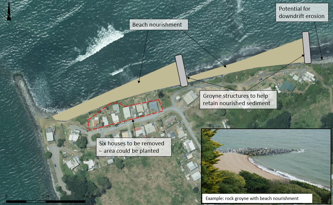
Groynes (control structures)
Description
Groynes are structures placed perpendicular to the shoreline with the intent of trapping or
‘controlling’ sediment as it is moved alongshore by waves and longshore drift
(Figure 3.5). Groynes
can assist with promoting sediment retention and accumulation to restore the natural buffering
capacity of the shoreline to erosion through creation of a more stable beach. On higher energy
shorelines, such as Waitara, groyne structures are typically constructed from rock.
Technical considerations
The length and spacing of the structures can vary depending on the desired beach width. An initial
beach nourishment would be required within the groynes, with the frequency and magnitude of re-
nourishment and beach maintenance considerably less than a stand-alone re-nourishment option.
As groynes promote sediment accumulation on the up-drift side of the structures, there can be
reduced sediment supply and subsequently increased erosion rates on the downdrift shoreline (i.e.
along the golf course). However, this can be mitigated by pre-filling the groynes with nourishment
materials.
Effectiveness against erosion
If implemented with an initial beach nourishment, the groynes are likely to provide moderate
protection against coastal erosion over the short to medium term. To provide longer term
protection, some renourishment may be required immediately following storm events.
Tonkin & Taylor Ltd
March 2023
Coastal Hazard Management Options Assessment - Te Rohutu Block, Waitara East
Job No: 1001955.4000 v3
New Plymouth District Council
link to page 13 link to page 13
8
Effectiveness against inundation
Groynes have minimal impact at reducing the inundation hazard. Although, as with the beach
nourishment option, construction of a wider/higher beach can reduce the landward extent of wave
runup.
Figure 3.5: Plan view showing example of groynes combined with beach nourishment
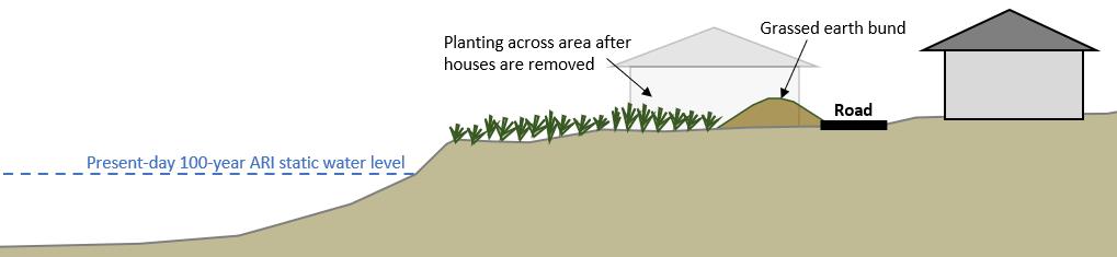
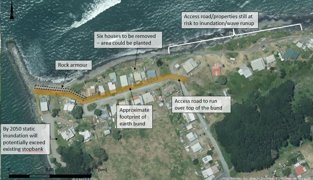
3.4
Bund/stopbank
Description
A bund is an artificial embankment intended to reduce coastal inundation of the land and is typically
set back from the existing coastal edge.
Technical considerations
A bund (approximately 1 m high) could be constructed, positioned along the seaward edge of East
Beach Road
(Figure 3.7 and
Figure 3.7). To avoid inundation outflanking the bund, it would need to
be tied in with the existing groyne structure and the higher elevated land near no. 29. The western
extent of the bund would most likely require some rock armouring along the seaward edge to
reduce the present-day risks of coastal erosion.
This option is considered to be relatively low cost and easy to implement compared to other hazard
mitigation options, although there is the risk of failure if coastal erosion reaches the structure and it
is undermined. An alternative option to an earth bund would be to construct a small vertical wall
which would have a smaller footprint than a sloping earth bund, although the same risk of failure
applies.
Effectiveness against erosion
The bund would have minimal effectiveness at mitigating coastal erosion. The erosion assessment
indicates that by approximately 2050 the bund may become at risk from coastal erosion and fail
without the introduction of additional coastal erosion mitigation measures.
Tonkin & Taylor Ltd
March 2023
Coastal Hazard Management Options Assessment - Te Rohutu Block, Waitara East
Job No: 1001955.4000 v3
New Plymouth District Council
9
Effectiveness against inundation
Without additional coastal erosion protection, the bund would only be suitable as short-term option
for mitigating wave runup, along East Beach Road and the properties further landward. The bund
would have limited effectiveness at mitigating inundation over the long-term as it will likely become
subject to erosion before inundation becomes an issue and inundation will likely occur from the river
side before it floods over the dune crest.
Due to the position of the access road and immediate erosion risk in front of properties no. 22 to 26,
it would not be feasible to construct the bund seaward of these properties and therefore the bund
option alone does not protect properties no. 22 to 26 from inundation and wave runup effects.
However, based on the hazard assessment no. 22 to 25A are unlikely to be impacted by wave runup
over the next 100 years.
Figure 3.6: Indicative cross-section sketch showing the earth bund option
Figure 3.7: Plan view showing the approximate location of the bund
Tonkin & Taylor Ltd
March 2023
Coastal Hazard Management Options Assessment - Te Rohutu Block, Waitara East
Job No: 1001955.4000 v3
New Plymouth District Council
link to page 14 link to page 15
10
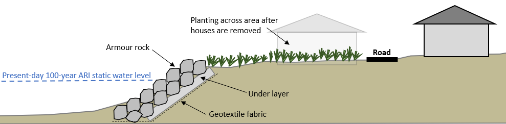
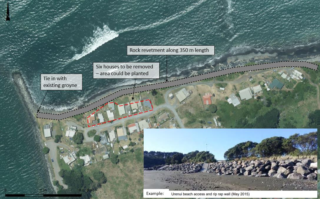
3.5
Rock revetment
Description
A rock revetment is typically comprised of a geotextile fabric to retain soil from the adjacent land, an
underlayer to cushion the geotextile and armour layers to protect the underlayers from wave attack
(Figure 3.8). As the rock surface is irregular and the rock armour layer is permeable the slope face of
the revetment is effective in dissipating wave energy and effective in reducing erosion if adequately
designed with a toe below potential scour levels and crest sufficiently high to reduce overtopping to
tolerable levels.
Rock revetments are flexible structures that can sustain settlements if the wall is undermined or be
damaged by waves exceeding their design and still retain function, although maintenance may be
required if significant movement of the armour rock occurs.
Technical considerations
A rock revetment could be constructed along the 350 m length of shoreline and tied into the existing
groyne at the western end
(Figure 3.9). Depending on the design, the design life of rock revetments
can be up to 50+ years and once constructed, maintenance is likely to be minimal.
It is also important to note that coastal protection structures, such as revetments and seawalls, are
intended only to protect the land behind the structure. They do not protect the fronting beach and,
on an eroding coast like Waitara East, it is expected the beach will gradually be lost from in front of
the structure. Similarly, they do not protect adjacent land from ongoing erosion. There is potential
for end effects to occur at the eastern extent of the structure which could result in increased erosion
near the golf course.
Rock revetments also reduce the beach access; however, this can be addressed with access stairs
incorporated into the design.
Effectiveness against erosion
With appropriate design, a rock revetment can provide a high level of protection against coastal
erosion over the medium to long-term.
Effectiveness against inundation
A sloping rock revetment can reduce the wave runup effects along the shoreline. Depending on the
design crest levels, this may provide some protection against inundation over the short to medium
term.
Figure 3.8: Indicative cross-section the rock revetment option
Tonkin & Taylor Ltd
March 2023
Coastal Hazard Management Options Assessment - Te Rohutu Block, Waitara East
Job No: 1001955.4000 v3
New Plymouth District Council
link to page 16
11
Figure 3.9: Plan view showing approximate extent of rock revetment
3.6
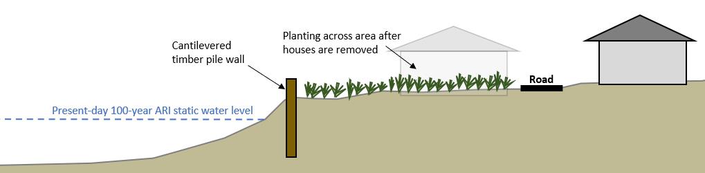
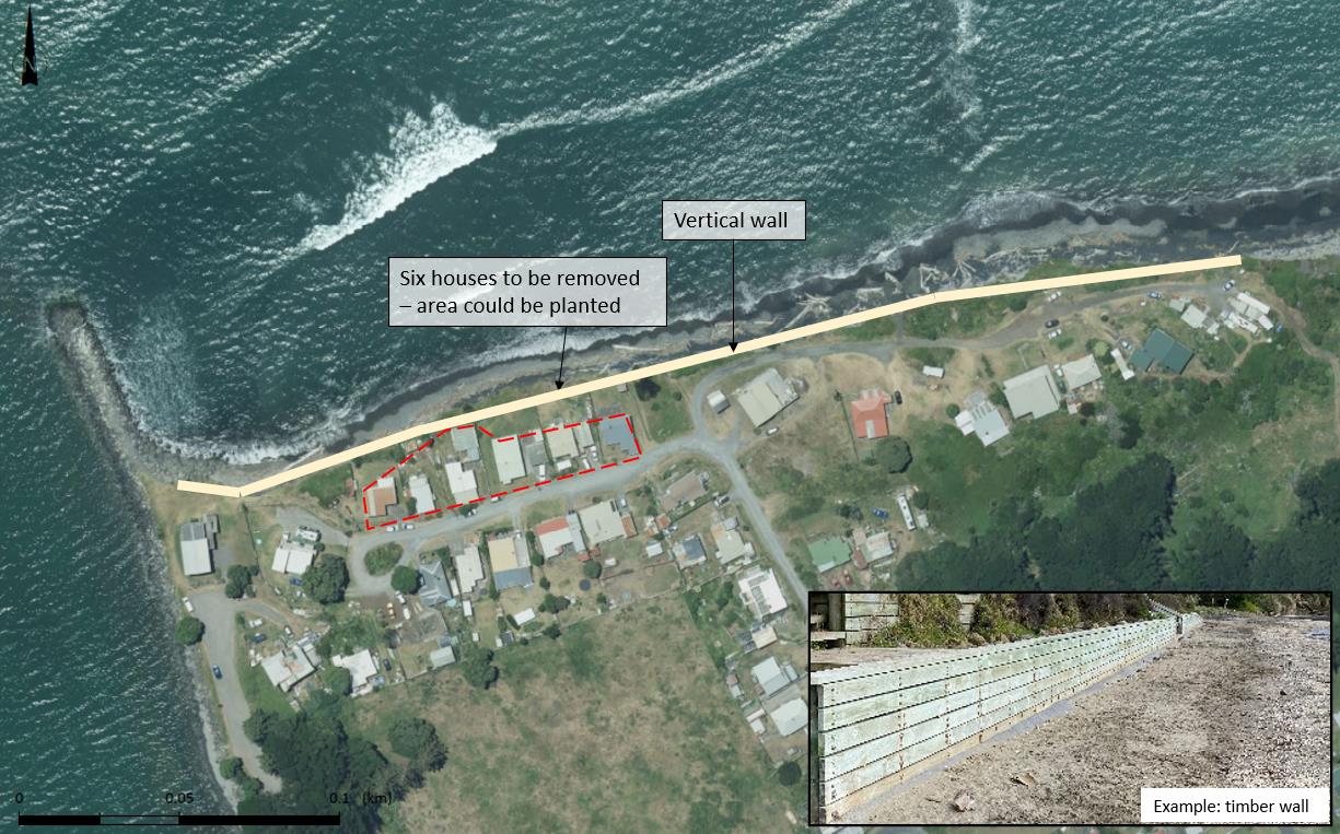
Vertical seawall
Description
A vertical seawall has a small footprint and provides a physical barrier to erosion by protecting and
retaining the dune behind the structure
(Figure 3.10). Construction materials can include timber,
concrete and sheet piles. The chosen material has implications for the design life and maintenance
requirements of the structure in addition to appearance and cost. For example, a timber wall may be
lower cost to construct compared to a rock revetment, however, it has a limited material design life
in the marine environment and is more prone to damage if beach levels drop and larger waves can
reach the structure.
Technical considerations
Vertical structures are do not dissipate wave energy effectively compared to other structures and
must be able to withstand the impacts of wave forces. Consequently, wave overtopping is higher
than for sloping structures and the structure itself will reflect a lot of wave energy which can result
in increased scour along the toe. Therefore, the wall must have sufficient toe embedment and or tie
backs in place to support the wall when the sand in front of the wall has been eroded.
As with rock revetments, seawalls are only intended to protect the land behind the structure. They
do not protect the fronting beach and, on an eroding coast like Waitara East, it is expected the beach
will gradually be lost from in front of the structure. Similarly, they do not protect adjacent land from
ongoing erosion. There is potential for end effects to occur at the eastern extent of the structure
which could result in increased erosion near the golf course.
Effectiveness against erosion
With appropriate design, a vertical seawall can provide a high level of protection against coastal
erosion over the medium to long-term. However, erosion of the beach levels at the toe of the wall is
likely to increase.
Tonkin & Taylor Ltd
March 2023
Coastal Hazard Management Options Assessment - Te Rohutu Block, Waitara East
Job No: 1001955.4000 v3
New Plymouth District Council
12
Effectiveness against inundation
Vertical walls can reduce wave runup effects along the shoreline. Depending on the design crest
levels, this may provide some protection against inundation over the short to medium term.
Figure 3.10: Indicative cross-section showing a vertical wall option (in this case a cantilevered timber pile wall)
Figure 3.11: Plan view showing vertical wall along seaward edge of shoreline
3.7
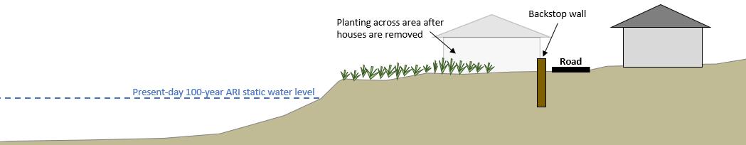
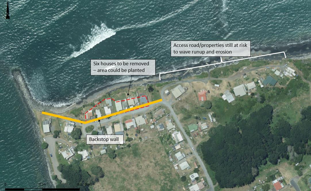
Backstop wall
Description
A backstop wall can be considered a vertical seawall that is located landward of the present-day
shoreline. They are designed to be predominantly covered by beach sediment and only exposed
during storm events or after a prolonged period of erosion, whereupon they perform a more
conventional seawall function
Technical considerations
With the six houses being removed, a backstop wall could be constructed along the seaward edge of
East Beach Road. However, due to the access road running along the shoreline edge further east,
there is negligible space to construct a backstop wall. As described in Section 3.6 a vertical wall could
Tonkin & Taylor Ltd
March 2023
Coastal Hazard Management Options Assessment - Te Rohutu Block, Waitara East
Job No: 1001955.4000 v3
New Plymouth District Council
13
be constructed along the shoreline edge for this section of the coast and linked to the backstop wall
further inland
The configuration of the backstop wall option is similar to the bund option (Section 3.4), however, if
constructed with sufficient toe depth (and potentially anchorage tie backs) the backstop wall may be
designed to provide a limit (backstop) to the erosion extent. Due to the likelihood of ongoing
erosion, the backstop wall should be considered to have the same effects as a standard seawall,
described in Section 3.6, once exposed.
A key consideration is the expected time until the wall may be exposed. Materials such as timber
have a limited design life, and this will effect the likely functional time the wall has once exposed.
Constructing a wall at depth may also require substantial excavations that could impact on current
assets such as the road.
Effectiveness against erosion
The backstop wall would not provide any erosion protection for the land seaward of the structure,
however it would provide some protection for the area landward of the structure, where depending
on the design, the structure could provide medium-term protection. With the backstop wall option
alone, it does not provide any erosion protection for the shoreline further east. This would require
an alternative option to provide a similar standard of protection.
With appropriate design, a backstop seawall can provide a high level of protection against coastal
erosion, once exposed, over the medium to long-term. However, erosion of the beach levels at the
toe of the wall is likely to increase.
Effectiveness against inundation
As with the vertical walls described in Section 3.6, a backstop wall can reduce wave runup effects.
Depending on the design crest levels, this may provide some protection against inundation over the
short to medium term.
Figure 3.12: Indicative cross-section sketch showing the backstop wall option
Tonkin & Taylor Ltd
March 2023
Coastal Hazard Management Options Assessment - Te Rohutu Block, Waitara East
Job No: 1001955.4000 v3
New Plymouth District Council
link to page 19 link to page 19
14
Figure 3.13: Plan view showing the approximate location of the backstop wall
3.8
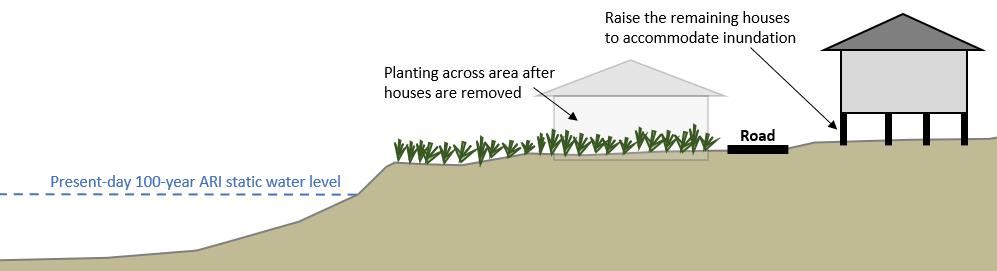
Accommodate (raise floor levels)
Description
Accommodating includes raising the floor levels of houses to reduce the impacts of wave runup and
static inundation
(Figure 3.14).
Technical considerations
The raising of floor levels can be done over different stages as the impact of wave runup, and static
inundation gradually shifts landward. The stages at which different houses are likely to require the
floor levels raised is shown in
Figure 3.15. There is potential that as the shoreline erodes, the houses
at no. 1 and 2 East Beach also become exposed to periodic inundation from wave runup by 2130.
Therefore, the floor levels within these houses could also be raised to accommodate impacts of
wave runup in the future.
Effectiveness against erosion
Raising the floor levels has negligible effectiveness at reducing the impacts of erosion along the
shoreline.
Effectiveness against inundation
This option would be effective at mitigating the inundation risk to the houses; however, the access
roads will still be at risk to periodic inundation.
Tonkin & Taylor Ltd
March 2023
Coastal Hazard Management Options Assessment - Te Rohutu Block, Waitara East
Job No: 1001955.4000 v3
New Plymouth District Council
15
Figure 3.14: Indicative cross-section showing the option of raising floor levels
Figure 3
.15: Houses that potentially need floor levels raised to accommodate period flooding during coastal
storm events. Timing that floor levels may require raising is based on the 100-year ARI dynamic water level
extents
3.9
Managed retreat
Description
An alternative option for managing the coastal erosion and inundation hazard risk is to remove the
houses and assets that are at risk to future coastal erosion and inundation. This may require
identifying an appropriate location for the houses/residents to be relocated outside of the currently
identified hazard zones.
Technical considerations
In practice the implementation of managed retreat can be difficult, with a number of practical and
legal challenges and a large number of landowners who may have conflicting views on how it should
be conducted. Questions of fairness, who pays, and the provision of any financial assistance take
time to resolve and currently there is no national guidance or standard legal framework to address
these issues. The soon to be released Climate Adaptation Act is expected to provide guidance to
Local Authorities on dealing with these issues.
Tonkin & Taylor Ltd
March 2023
Coastal Hazard Management Options Assessment - Te Rohutu Block, Waitara East
Job No: 1001955.4000 v3
New Plymouth District Council
link to page 20
16
The Climate Adaptation Act is part of the Government’s resource management reform programme
which will remove the Resource Management Act and replace it with new legislation. The Act will
address the managed retreat (or relocation) of key assets, activities and sites of cultural significance
to both Māori and non-Māori, within a certain timeframe.
Managed retreat could be staged over the long-term as the extent of hazards shift landward and
pose increased risk to the remaining houses
(Figure 3.16). Retreat would need to be implemented
once a trigger point is reached that is considered to represent an unacceptable risk from coastal
erosion and/or inundation hazards.
The cost of implementing managed retreat including land purchase is very high relative to the other
management options.
Effectiveness against erosion
Managed retreat is effective for mitigating the impacts of coastal erosion on assets.
Effectiveness against inundation
Managed retreat is effective for mitigating the impacts of coastal inundation on assets.
Figure 3.16: Houses potentially at risk to coastal erosion over the next 100 years and the timeframes over
which managed retreat may be required
3.10
Combination of options (adaptive management)
The options outlined above have different effectiveness and suitability for mitigating the different
coastal hazards (i.e. erosion and inundation) along Te Rohutu Block. Due to the different coastal
hazards occurring over different temporal and spatial scales the most suitable management option
for Te Rohutu Block is likely to be a combination of options implemented at different stages as part
of a Dynamic Adaptive Pathways Planning (DAPP) as recommended by the MfE guidance (MfE,
2017).
Tonkin & Taylor Ltd
March 2023
Coastal Hazard Management Options Assessment - Te Rohutu Block, Waitara East
Job No: 1001955.4000 v3
New Plymouth District Council
17
Adaptive pathways help to accommodate for the uncertainty around the timing of hazards through
providing a plan where adopted management options are revisited and adjusted as conditions
change. An adaptative pathway typically includes predetermined trigger points where a decision for
a new or adjusted management option is required if the existing management option is failing to
provide sufficient protection. The pathway can be designed to include both short-term actions and
long-term options.
As an example, removal of the six properties and instatement of a bund to protect the remaining
properties from coastal inundation may be effective in the short term. However, with continued
erosion and increases in sea level rise this option is likely to reach a trigger point where it no longer
provides an acceptable level of protection. When this point is reached an alternative option would
be required that might include upgrading the defence to a rock revetment or ultimately retreating
the affected assets.
The creation, and evaluation, of adaptation pathways is outside the scope of this work. However, the
options presented provide the basis for community and stakeholder engagement from which an
adaptive plan could be developed.
4
Summary
This report sets out potential hazard management options to reduce the present day and future risks
from coastal erosion and inundation. Options are presented at a conceptual level with sketches and,
where appropriate, photographs of similar structures to provide clarity to the community on the
appearance and visual impact of each option. Additional information on the relative costs, design life
and effectiveness of each option are presented and are intended to form the basis for discussion
with the community on preferred options. A summary of the different management options is
provided in
Table 4.1.
Due to the different coastal hazards (i.e., erosion and inundation) occurring over different temporal
and spatial scales the most suitable management option for Te Rohutu Block is likely to be a
combination of options implemented at different stages. As part of a longer-term adaptation
strategy, it may also be necessary to upgrade options or replace them with alternatives in order to
maintain an acceptable degree of protection.
Tonkin & Taylor Ltd
March 2023
Coastal Hazard Management Options Assessment - Te Rohutu Block, Waitara East
Job No: 1001955.4000 v3
New Plymouth District Council
18
Table 4.1: Summary of potential management options for Waitara East
#
Management
Effectiveness
Relative
Technical benefits
Technical barriers
option
cost
Erosion
Inundation
1
Do nothing
Low
Low
Nil1
-No direct costs for engineered hazard
-Ongoing and increasing coastal hazard risk. Based
adaptation options.
on our assessment (T+T, 2023) some of the
remaining houses are likely to become exposed to
coastal erosion and wave runup over the next 10
years.
2
Beach
Moderate
Low
Moderate
-Maintains beach access.
-Large volume of sediment required.
renourishment
-Improves beach amenity.
-Likely to be ongoing loss of material over time
and does not guarantee protection without
frequent and timely maintenance
-Regular monitoring and additional nourishment
required to maintain beach levels which will
significantly increase option lifetime costs.
3
Groynes +
Moderate
Low
High
-Reduces rate of alongshore sediment transport
-May further reduce sediment supply and increase
renourishment
and allows build-up of material on up-drift side.
erosion rates of downdrift shoreline.
-Promotes an increased beach width and
-Maintenance/additional nourishment required,
maintains beach access.
but less frequent compared to stand alone
nourishment
4
Bund/
Low
High
Low
- Relatively low cost.
- Does not reduce coastal erosion.
stopbank
- No impact on the existing shoreline.
- Does not reduce inundation in the long-term.
- Not viable in some areas due to limited space
and erosion risk.
5
Rock
High
Moderate
High
-Long design life.
- Beach loss over time
revetment
-Reduced wave overtopping and scour of the
- Sloping structures can have larger footprint.
beach compared to vertical wall options.
- Potential for end effects near the golf course.
- Beach access reduced.
Tonkin & Taylor Ltd
March 2023
Coastal Hazard Management Options Assessment - Te Rohutu Block, Waitara East
Job No: 1001955.4000 v3
New Plymouth District Council
19
#
Management
Effectiveness
Relative
Technical benefits
Technical barriers
option
cost
Erosion
Inundation
6
Vertical
High
Moderate-
Moderate-
-Smaller footprint that does not occupy an area
- Vertical structure will result in higher
seawall
High
High
on the current beach when compared to sloping
overtopping rates than a comparable sloping
structures.
structure.
-Impermeable structures provide protection
- Beach loss over time
against erosion and inundation.
- Potential for end effects near the golf course
-Deep embedment required for structural support
to reduce undermining risk.
-Wave reflection at the structure may result in
lowering of beach levels in front of the structure
due to scour and liquefaction effects.
-Timber structure has shorter design life.
7
Backstop wall
Moderate
Moderate
Moderate
-Allows for area of natural beach to remain in
-Potential for end effects at eastern end once the
the short-medium term, whilst providing a limit
shoreline erodes to the seaward edge of structure.
to the potential erosion extent during large
-Eventually wave reflection at the structure may
storm events and/or continued erosion.
result in lowering of beach levels in front of the
structure.
8
Accommodate
Low
Moderate
Low-
- Reduces flooding of houses from wave runup
- Does not reduce coastal erosion.
Moderate
with no impact on the existing shoreline.
9
Managed
High
High
Very high
- Reduces current and future erosion and
- Difficult to implement due to questions around
retreat
inundation risk by removing vulnerable assets
fairness, who pays, and the provision of any
from the hazard area.
financial assistance taking time to resolve.
1 Emergency response and management costs likely and loss of public and private assets.
Tonkin & Taylor Ltd
March 2023
Coastal Hazard Management Options Assessment - Te Rohutu Block, Waitara East
Job No: 1001955.4000 v3
New Plymouth District Council

20
5
Applicability
This report has been prepared for the exclusive use of our client New Plymouth District Council, with
respect to the particular brief given to us and it may not be relied upon in other contexts or for any
other purpose, or by any person other than our client, without our prior written agreement.
Tonkin & Taylor Ltd
Environmental and Engineering Consultants
Report prepared by:
..........................................................
...........................….......…...............
Rebekah Haughey
Jonathan Clarke
Coastal Scientist
Senior Coastal Engineer
Reviewed by:
Authorised for Tonkin & Taylor Ltd by:
..........................................................
..........................................................
Dr Tom Shand
James Russell
Technical Director Coastal Engineering
Project Director
RHAU
t:\auckland\projects\1001955\1001955.4000\issueddocuments\te rohutu management options final report
v3\r20230308.managementoptions.waitaraeast.v3.final.docx
Tonkin & Taylor Ltd
March 2023
Coastal Hazard Management Options Assessment - Te Rohutu Block, Waitara East
Job No: 1001955.4000 v3
New Plymouth District Council