 FILE NOTE
OFFICE: Hokitika
DATE: July 7 2019
STAFF: J Marshall DOC and C Phelps WCRC
SUBJECT: Variation 1 WCRC Land and Water Plan – outstanding wetland delineation.
Background
The Commissioners hearing submissions on Variation 1 to the West Coast Regional Council Land
and Water Plan requested a determination of wetland status on three outstanding properties;
BULP050 Oweka, HOC004 Candlelight and part PUNP001 Barrytown.
Each of the properties were visited by DOC Ecology and Regional Council Planning staff, and
surveys were undertaken in accordance with the methodology described in Clarkson (2013) using
the prevalence and dominance of hydrophytic vegetation as an indication of wetlands (refer
Appendix 1).
Coates part PUNP001 Barrytown
Two plots were in the L shaped 1.3ha of forest cover in the section of the Coates property adjacent
to the Coast Road Scenic reserve and Barrytown Flat Conservation Area. At the widest part the
patch of forest was approximately 80m. The forest understory is very disturbed and there is little
undergrowth or regeneration of forest species. The land use to the south and east of this forest
edge has affected the vegetation structure and composition in this edge of the Maher Swamp
Schedule 2 wetland.
The results of the Dominance and Prevalence tests show that the forest patch was determined
not to be wetland (Table 1) using the methods provided in Clarkson et al (2013).
Plot number
Dominance Test
Prevalence Test
Conclusions
DT >50 = hydrophytic PI ≤ 3 = Hydrophytic
species dominance
species prevalence
1
28
3.08
Clearly not hydrophytic
2
33.3
3.22
Clearly not hydrophytic
Table 1. Result of the Vegetation tests of Dominance and Prevalence at PUNP001.
The public conservation lands adjacent to the western and northern boundary of the Coates
property remain in Schedule 2 of the Land and Water Plan and this area is highly likely to hold
significant wetland values. Some activities on the boundary, such as development of new drains,
are very likely to have adverse effects on the adjacent areas of PUNP001 Schedule 2 wetland.
Terrestrial Science Unit
Hokitika – West Coast, New Zealand
Telephone 0272790375
1
 O’Regan Oweka BULP050
BULP050 is approx. 23ha forest vegetation, described as kahikatea, and is entirely within the
O’Reagans property. It is adjacent to and connected with other public conservation lands which
also support forest vegetation.
Four plots were located in the 23ha forest. The forest, which had been described as kahikatea
forest also contained significant amounts of silver beech and rimu. The soils were not saturated
however, they were soft to the probe at all 4 sites.
The interpretation of the dominance and prevalence of wetland species tests were not definitive
(Table 2). Only one obligate wetland species was recorded, and six of the seven dominant species
were facultative upland species, in two plots kahikatea dominated and in two plots it was co-
dominant with silver beech and rimu. For these reasons we recommend the area is removed
from Schedule 2.
Plot number
Dominance Test
Prevalence Test
Conclusions
DT >50 = hydrophytic PI ≤ 3 = Hydrophytic
species dominance
species prevalence
1
40
2.98
Marginally not hydrophytic
2
28.6
4
Clearly not hydrophytic
3
50
3.7
Not hydrophytic
4
50
2.78
Unclear
Table 2
Bradleys - Part Candlelight Pakihi HOCP004
The large 650ha wetland identified in Schedule 2 of the Land and Water Plan lies partly (approx.
55ha) on the Bradleys property. The Bradleys disputed the inclusion of their land in the wetland.
In 2014 DOC and WCRC assessed the wetland on the Bradleys property and agreed with the
Bradleys that approx. 30ha of the northern part of the wetland had been so altered by the
combination of multiple drains, grazing, and over-sowing, that it was no longer a functioning
wetland, however the southern 25ha of the wetland was assessed as wetland (Figure1).
Nine plots were surveyed on the approx. 25ha area in question on the Bradleys property during
two field trips of May and June 2019 (Figure 2). The plots were positioned on three transects that
ran east to west across the area. Two plots were placed in the narrow southern end of the
wetland, three plots across a transect through the middle and four plots across the northern end
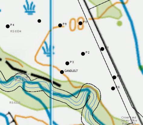
of the area of interest. Plot 1 and 9 appear to be on the boundary of the Bradleys property and
road reserve (Fig 3). The eastern edge of the area in question on the Bradleys property is
functionally connected to the larger part of the Candlelight Pakihi along approx. 700m of the
boundary. The soils through - out the area of interest were soft and easily probed to a depth of
0.5 m in most plots.
Terrestrial Science Unit
Hokitika – West Coast, New Zealand
Telephone 0272790375
2

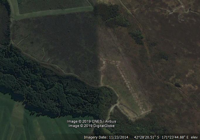
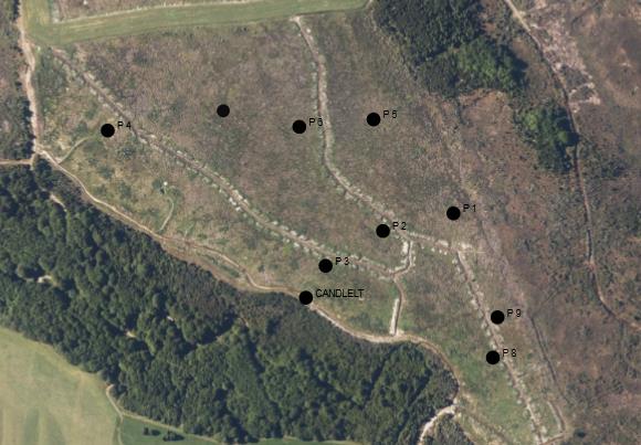 Figure 1.
 The southern section of wetland at 23/11/2014.
P7
Figure 2. The southern part of the wetland in 2019 with position of vegetation plots. Red line
indicates connected part of wetland.
Terrestrial Science Unit
Hokitika – West Coast, New Zealand
Telephone 0272790375
3

Four of the nine plots are clearly hydrophytic, three plots are clearly not hydrophytic and at two
plots the data is not conclusive (Table 3).
Plot number
Dominance Test
Prevalence Test
Conclusions
DT >50 = hydrophytic PI ≤ 3 = Hydrophytic
species dominance
species prevalence
1
50
2.96
Marginally hydrophytic
2
50
2.53
Marginally hydrophytic
3
33
3.12
Clearly not hydrophytic
4
75
2
Clearly hydrophytic
5
100
2
Clearly hydrophytic
6
66.6
2.78
Clearly hydrophytic
7
75
2.22
Clearly hydrophytic
8
50
3.19
Clearly not hydrophytic
9
50
3.5
Clearly not hydrophytic
Table 3
P7
Figure 3. Property boundaries and vegetation plots at the Bradleys.
The data suggests that one third of the area is wetland (plots 4,5,6,7) the most northern third of
the area of interest. The southern two thirds (described by plots 1,2,3,8,9) do not support
hydrophytic vegetation.
Terrestrial Science Unit
Hokitika – West Coast, New Zealand
Telephone 0272790375
4

The part of the Bradleys property adjacent to the rest of the Candlelight Pakihi on the western
boundary (Figure 2) has greatest value as it is still connected to the larger wetland, and
hydrophytic vegetation is present in the area.
Fragmentation of the area as determined by the results of the data analysis would result in an
impractical outcome; approximately 5 ha has been determined to be wetland but it would sit
between two larger dry areas, and likely its value as wetland would not be retained in the long
term.
Reference:
Clarkson, B.R. 2013: A vegetation tool for wetland delineation in New Zealand. Landcare Research.
Waikato.
Appendix 1
Definitions
Hydrophytic vegetation: wetland species -including wetland obligates, facultative wetland species
and facultative species
Obligate species: almost always is wetlands, rarely in uplands.
Facultative wetland: usually is in wetlands but occasionally found in uplands
Facultative: commonly occurs in wetlands and in areas which are not wetlands.
Dominance Test. Determines the proportion of dominant species on the plot that are
hydrophytic.
Prevalence Test: determines whether the plot is covered mostly by hydrophytic or non-
hydrophytic species.
Terrestrial Science Unit
Hokitika – West Coast, New Zealand
Telephone 0272790375
5