

Attachment B
Report
East West Connections: Coastal Process
Assessment to Support Option Selection
ACT
Prepared for the NZ Transport Agency and Auckland Transport
THE
Prepared by Beca Ltd
15 October 2014
UNDER
INFORMATION
RELEASED
OFFICIAL

Contents
Executive Summary
1
1 Introduction
2
1.1
The project
2
1.2
The Options
2
1.3
Key design assumptions
3
2 Site Description
4
2.1
Physical Environment
4
2.2
Coastal Processes
5
3 Assessment of Options
8
3.1
Assessment of Option D
8
THE ACT
3.2
Assessment of Option E
8
3.3
Assessment of Option F
8
3.4
Consideration of Climate Change
9
3.5
Mitigation Measures
9
4 Conclusion and Recommendation
10
5 Bibliography
11
UNDER
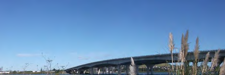
Cover Photo: View of the new Manukau Harbour Crossing bridge from the Waikaraka cycleway
INFORMATION
RELEASED
OFFICIAL
East West Connections: Coastal Process Assessment to Support Option Selection // // NZ1-9693877-1 0.1 // 15 October 2014 // i
 Revision History
Revision Nº
Prepared By
Description
Date
Revision History
Revision Nº
Prepared By
Description
Date
1
Connon Andrews
Draft
9 October 2014
2
Connon Andrews
Final
15 October 2014
Document Acceptance
Action
Name
Signed
Date
Prepared by
Connon Andrews
15 October 2014
Reviewed by
Andrea Rickard
15 October 2014
Approved by
Andrea Rickard
15 October 2014
on behalf of
Beca Ltd
THE ACT
UNDER
INFORMATION
RELEASED
OFFICIAL
East West Connections: Coastal Process Assessment to Support Option Selection // // NZ1-9693877-1 0.1 // 15 October 2014 // ii

Executive Summary
Executive Summary
A qualitative review of coastal processes has been completed for East West Connection Road alignment
Options D, E and F that will encroach into the Coastal Marine Area (CMA).
Mangere Inlet and Onehunga Bay have been subject to significant change since the mid 1800’s and has
been the location of several large scale industrial developments that has resulted in environmental
degradation of the CMA (ARC, 2009). Ongoing development has resulted in reclamation of the foreshore
concentrated along the northern embankment of the Mangere Inlet and to the west of Gloucester Park. It is
estimated that up to 1.2 km2 has been reclaimed within the inlet (Northern Gateway Alliance, 2006). The
coastal edge is protected by a variety of coastal structures including tipped rock, rock revetments and vertical
seawalls offering varying degrees of coastal erosion protection. Sediments within the study area have been
documented to have high levels of contaminants that include copper, zinc, lead, ddt, dieldrin and arsenic.
Due to the extensive intertidal nature of the Manukau Harbour ambient wave, current and sedimentation
processes are relatively benign. Accordingly, beach widths are either narrow or absent particularly at high
ACT
water levels exposing the foreshore embankment directly to coastal processes. This has resulted in the hard
THE
lining of the coastal edge with erosion protection.
The proposed alignment options requires further reclamation within Mangere Inlet of up to 0.19 km2 (Option
F) decreasing the inlet area by 3% and localised reclamation within Onehunga Bay of 0.0125 km2. Due to the
scale and location of the proposed reclamations outlined in Options D, E and F the effects on coastal
processes are expected to be negligible. However, some local morphological adjustment within Mangere
Inlet is expected where the proposed reclamations encroach existing tidal channels.
UNDER
With reference to the status quo the relative effects on coastal processes are directly related to reclamation
area, thereby resulting in the following ranking (lowest to highest effects):
n Option D
n Option F
n Option E
INFORMATION
It is recommended that irrespective of which option is selected that appropriate coastal erosion protection
solutions are installed along the existing and/or future reclamation edge to minimise land loss and release of
historic fill material to the CMA. This would result in beneficial impacts overall on the shoreline edge.
RELEASED
OFFICIAL
©Beca 2014. This proposal has been prepared by Beca Ltd (“Beca”) for (“the Client”) and contains confidential information including the proposed methodology that is the property of Beca. The Client is
permitted to use this information solely for the purpose of evaluating Beca’s suitability for providing the proposed services. The Client shall not disclose this information to any other person (other than
to its partners officers advisors and employees on a strict “need to know” basis) and acknowledges that Beca will suffer a loss if this information is disclosed or used other than as set out above”.
East West Connections: Coastal Process Assessment to Support Option Selection // 15 October 2014 // 1

Introduction
1
Introduction
1.1
The project
The East West Connections project is responding to the immediate and growing freight access issues at
either end of the Neilson Street/Church Street corridor caused by inefficient transport connections and a lack
of response to changes in the industry’s supply chain strategies. The project is also addressing the
inadequate quality of transport choices between Māngere, Ōtāhuhu and Sylvia Park.
The long list of potential route options was developed in a 2-stage process. The option identification process
began with identifying changes at a component level (e.g. lane widening; interchange improvements) across
the geographical area. To ensure a full spectrum of components was considered, the study area was
separated into segments and all components were then assessed through a multi-criteria analysis. Where
broadly equivalent components (in terms of either transport performance or social, environmental or cultural
outcomes) were identified, the best alternative proceeded to the development of the long list options. If no
broadly equivalent alternative component existed, the component was progressed to the development of
long list options. All options were assessed through a multi-criteria analysis, which considered a full range of
THE ACT
impacts and performance against the project’s objectives and the East West Connections outcomes. Six
options were identified to progress to the short list for the Onehunga-Penrose connection.
1.2
The Options
Of the shortlisted options, three of the six include encroachment into the Coastal Marine Area (CMA) and
hence are subject to coastal processes.
UNDER
It is noted that Option C has a small portion skirting the edge of the coastal marine area at Ann’s Creek, and
assessments of the following three options have regard to the same issues.
The three options are:
Option D (Long List Option 8): Upgrade with Gloucester Park interchange and new Galway St and inland
connections (refer to Drawing 3818663-08-1001 in Appendix 1).
INFORMATION
This option proposes an upgrade at Gloucester Park Interchange and a new connection from Onehunga
Harbour Road to Galway Street. It also proposes an upgrade of Neilson and Angle Streets and Sylvia Park
Road, and a new connection for Angle Street to Sylvia Park Road and to SH1.
RELEASED
The proposed option calls for a reclamation adjacent to Gloucester Park for the interchange and relocation of
the Scott Club facilities. The proposed reclamation area is approximately 12,500 m2 over a longshore
distance of 450 m.
Option E (Long List Option 13): New foreshore Connection
OFFICIAL
This option proposes a new connection from SH20 to SH1 along the northern shoreline of Mangere Inlet
(refer to Drawing 3818663-13-1001 to 3818663-13-1004 in Appendix 1). The proposed option calls for the
following:
n New interchange at SH20 at Gloucester Park with approximately 7,500 m2 of reclamation along 450 m of
shoreline for road alignment and relocation of Scott Club facilities.
n New connection from Gloucester Park along foreshore to Great South Road, with local connections at
Captain Springs Road, Southdown (Metroport) and Great South Road to connect (via intersection) onto
Vesty Drive. The road will require approximately 190,000 m2 (0.19 km2) of reclamation along 2.9 km of
shoreline.
East West Connections: Coastal Process Assessment to Support Option Selection // 15 October 2014 // 2

Introduction
n New bridge from Vesty Road to provide new ramp connection to SH1 at Panama Road. The proposed
bridge extends past the outlet of Ann’s Creek.
Option F (Long List Option 14): New foreshore and inland connection
This option proposes a new connection from SH20 to SH1 partly along the foreshore and partly inland (refer
to 3818663-14-1001 to 3818663-14-1004 in Appendix 1). The proposal calls for the following:
n New interchange at SH20 at Gloucester Park, with access to Neilson Street and onto Onehunga Harbour
Road with approximately 7,500 m2 of reclamation along 450 m of shoreline.
n New connection from Gloucester Park along foreshore to Captain Springs Road with approximately
110,000 m2 (0.11 km2) of reclamation along 1.7 km of shoreline and then inland to Great South Road.
For the purposes of this report only the above options have been considered and hereon referred to as the
“options”.
1.3 Key design assumptions
ACT
It is assumed that:
THE
n The proposed seaward edge of the reclamation will be protected with a tipped rock revetment.
n Appropriate sea level rise levels will be accommodated in the design
n Along the north shore of Mangere Inlet the proposed design of the foreshore options E and F calls for an
embankment approximately 60 metres wide to accommodate a four lane road carriageway and a shared
path and cycle way with swales for stormwater treatment. The embankment is separate from the existing
foreshore and as such it will create an area between the two that can be used for additional treatment and
UNDER
containment of any leachate etc.
n The intended construction could include pre loading and in situ wick drainage to reduce long term
settlement and the finished road carriageway elevation will be 4.5 m above mean sea level. It is
anticipated that some ‘headland’ features would be constructed to provide a more natural coastal edge.
n Existing drainage to the Mangere Inlet will be provided for using culverts.
INFORMATION
RELEASED
OFFICIAL
East West Connections: Coastal Process Assessment to Support Option Selection // 15 October 2014 // 3


Site Description
2
Site Description
The project traverses the northern shores of Mangere Inlet and with proposed road alignments potentially
affecting the northern shoreline of the Mangere Inlet and the shoreline west of Onehunga Port adjacent to
Gloucester Park.
2.1
Physical Environment
2.1.1
Mangere Inlet
Mangere Inlet is a rectangular shaped estuary comprising of 6.6 km2 of shallow tidal creeks and large
expanses of intertidal mud flats. The northern shore of the inlet is highly modified due to port activities,
roading and coastal reclamation. This has led to the loss of three embayments at the inlets to historic
streams, and also the loss of tidal inundation to the Hopua volcanic crater forming Onehunga Basin (Figure
2.1). The coastal edge is partially protected from erosion by tipped rock, vertical seawalls and engineered
riprap revetments.
THE ACT
UNDER
Onehunga Bay
Ann’s Creek
Mangere Inlet
INFORMATION
RELEASED
Figure 2.1 – Changes in the northern shorelines between 1940 (shaded) and 2006. Source ARC (2009).
OFFICIAL
Ann’s creek remains in the northeast corner of the inlet, although it is highly modified with only a short
section of open stream remaining. Extensive reclamation along the eastern shore of Mangere Inlet was also
carried out in the 1960’s, in relation to the development of the Westfield rail yards (ARC, 2009).
The southern shore is less modified, with inlets to Harania and Tararata Creeks still largely intact, although
the upper reaches of both creeks are dissected by high volume roads. Both creeks are heavily forested with
mangroves.
2.1.2
Onehunga Bay
The development of SH20 and Mangere Bridge has resulted in the extensive reclamation to the west of
Onehunga Port (refer to Figure 2.1). The coastal fringe is lined with conventional sloping rock rip rap along
East West Connections: Coastal Process Assessment to Support Option Selection // 15 October 2014 // 4


Site Description
the majority of SH20, with the slope varying from around 2.5(H):1(V) at the northern end to the Manukau
Cruising Club, with larger diameter rock and steeper slopes from the boat club to the Scout hall.
An offshore rock breakwater is located immediately to the south of the boat club that provides a more
sheltered environment to the seawall in this area.
THE ACT
UNDER
Figure 2.2 – Gloucester Park coastal protection. Source: Northern Gateway Alliance (2006). (It is noted that there is current reclamation
being undertaken as part of the Onehunga foreshore beach construction project at present).
2.2
Coastal Processes
INFORMATION
2.2.1
Water Levels
Water levels throughout the project site are generally consistent apart from minor elevation of water levels
within the Mangere Inlet due to the channel constriction at the Mangere Bridge. Astronomical tidal levels and
RELEASED
extreme sea levels (NIWA, 2013) are presented in Table 2.1.
Table 2.1 – Tidal Water Levels
Water Level
RL (m)
100 yr
3.00*
OFFICIAL
50 yr
2.92*
Highest Astronomical Tide (HAT)
2.34
Mean High Water Springs (MHWS)
1.97
Mean High Water Neaps (MHWN)
1.12
Mean Sea Level (MSL)
0.22
Mean Low Water Neaps (MLWN)
-0.75
Mean Low Water Springs (MLWS)
-1.64
Lowest Astronomical Tide (LAT)
-2.08
Source: NIWA(2013)* and Northern Gateway Alliance (2006).
East West Connections: Coastal Process Assessment to Support Option Selection // 15 October 2014 // 5


Site Description
Future climate change is expected to increase still water levels with the latest guidance from MfE (2009)
suggesting a minimum base level allowance on 0.5 m and a requirement to consider the consequence of a
minimum sea level rise of 0.80 m by 2099.
2.2.2
Wind
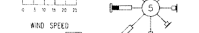
The prevailing surface wind direction as presented in Figure 2.3 is predominantly from the south-west (26%),
west (10%) and from the north to north-east (24%). The dominant winds speeds occur in the range of 2 to 4
m/s (42%) while speeds in excess of 9 m/s occur for 15% of the time. Sustained winds over 15 m/s rarely
occur (0.2%).
THE ACT
UNDER
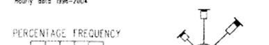
Figure 2.3 – Wind Rose from Auckland Airport (hourly data from 1996 to 2004) source: Northern Gateway Alliance, 2006.
2.2.3
Wave Climate
Wave conditions within the Manukau Harbour are fetch limited and dominated by locally generated wind-
INFORMATION
waves. Onehunga Bay is exposed to a 17 km southwest fetch which corresponds to the prevailing wind
conditions. Within Mangere Inlet the wave climate is relatively benign with a maximum fetch of 3.5 km.
In both areas the wave climate is dependent on water level with depth limited conditions and friction losses
occurring as waves propagate across the intertidal flats. Nearshore seabed levels are approximately RL -
RELEASED
0.4m with the majority of the shoals within Onehunga Bay situated at Mean Sea Level (MSL). Typical
significant wave heights (Hs), peak wave periods (Tp) and the percentage occurrence per year (%/yr)
calculated via the Young and Verhagen method at MHWS are presented in Tables 2.2 and 2.3.
Table 2.2 – Predicted Wave climate within Onehunga Bay
OFFICIAL
Wind Speed
3 m/s
7 m/s
10 m/s
15 m/s
Direction
Hs
Tp
%/y
Hs
Tp
%/yr
Hs
Tp
%/yr
Hs
Tp
%/yr
S
0.06
0.90
7.00 0.15
1.40
2.00
0.23
1.70
0.75
0.36
2.10
0.25
WSW
0.11
1.30
9.00 0.29
2.00
10.0
0.42
2.40
4.00
0.64
3.10
3.00
SW
0.08
1.10
4.50 0.20
1.60
5.00
0.29
2.00
2.50
0.45
2.40
1.00
W
0.06
1.00
4.00 0.17
1.50
2.00
0.25
1.80
1.00
0.38
2.20
0.25
East West Connections: Coastal Process Assessment to Support Option Selection // 15 October 2014 // 6

Site Description
Table 2.3 – Predicted Wave climate within Mangere Inlet
Wind Speed
3 m/s
7 m/s
10 m/s
15 m/s
Direction
Hs
Tp
%/y
Hs
Tp
%/yr
Hs
Tp
%/yr
Hs
Tp
%/yr
S
0.06
1.00
7.00 0.13
1.50
2.00
0.19
1.80
0.75
0.28
2.10
0.25
WSW
0.08
1.30
9.00 0.18
1.80
10.0
0.26
2.10
4.00
0.38
2.50
3.00
SW
0.08
1.30
4.50 0.19
1.90
5.00
0.27
2.20
2.50
0.40
2.60
1.00
W
0.06
1.00
4.00 0.13
1.50
2.00
0.19
1.80
1.00
0.28
2.10
0.25
According to Tables 2.2 and 2.3 ambient wave conditions are generally less than 0.2 m and 0.3 m within
Mangere Inlet and Onehunga Bay respectively the majority of the time. During extreme storm conditions
significant wave heights of 1 m are likely within Onehunga Bay (Northern Gateway Alliance, 2006). Within
Mangere Inlet significant waves heights during storm events have the potential to reach 0.5 m.
2.2.4
Tidal Currents
Tidal velocity information is available within the main channel adjacent to the Onehunga Wharf (NZ4314,
THE ACT
LINZ). The data suggests peak flood tide velocities of 1 m/s during springs tides and up to 0.6 m/s during
neap tides. During ebb tidal flows peak spring and neap tidal velocities of 0.80 m/s and 0.45 m/s
respectively are expected.
Observations from previous hydraulic investigations identified that on a flood tide there is a separation of
flows at White Bluff due to a large shoal in this location. One stream following the main channel and a
second swinging into Onehunga Bay flowing around the bay approaching the wharf from the northwest.
During ebb tides the flow is confined to the main channel (Northern Gateway Alliance, 2006).
UNDER
2.2.5
Sedimentation
Seabed sediments within the Mangere Inlet and Onehunga Bay are comprised of sandy mud with outcrops
of gravelly sandy mud with areas of calcium carbonate in excess of 50% (ARC, 2009). Suspended sediment
rates are relatively high with a median of 26 mg/l with a long term range between 10 to 150 mg/l (ARC,
INFORMATION
2009). Sedimentation concentration of up to 1 m a year have been observed at the Onehunga Port during
annual maintenance dredging.
ARC (2009) completed an assessment of sediment contamination throughout the Manukau Harbour and
identified that the Mangere Inlet had the highest levels in the harbour of lead, copper and zinc. Repeated
RELEASED
sampling between 1998 and 2007 has identified a trend of increasing zinc concentration and highly variable
concentrations of copper and lead at the Mangere Cemetery and Ann’s Creek monitoring sites. Sediment
concentrations of other notable metal and organic contaminants were low relative to sediment quality
guideline values at the Manukau State of the Environment (SoE) monitoring sites (ARC, 2009). The
exceptions were the Mangere Inlet monitoring sites adjacent to the Mangere Cemetary and Ann Creek that
OFFICIAL
include:
n dieldrin, which exceeds the ARCs environmental response criteria guideline value.
n DDT concentrations which are approaching Threshold Effects Level (ARC, 2009)
n arsenic, which exceeds ERL sediment quality guideline values (i.e. 8.2 mg kg-1).
East West Connections: Coastal Process Assessment to Support Option Selection // 15 October 2014 // 7

Assessment of Options
3
Assessment of Options
This assessment of options has only considered those options that impact on the foreshore. Coastal
process issues related to Option C are largely limited to the Gloucester Park and Ann’s Creek area and the
following assessments of Options D, E and F address issues common to these areas.
3.1 Assessment of Option D
The potential impact on coastal processes is limited to the potential 12,500 m2 reclamation adjacent to
Gloucester Park. The proposal calls for a reclamation width of up to 40 m to accommodate the road
alignment, car park and relocated Scott Club facilities including a boat ramp.
The existing shoreline is partially protected by an offshore breakwater with the coastal edge protected by a
tipped rock revetment. In some areas construction rubble has been used as coastal armour (Northern
Gateway Alliance, 2006).
THE ACT
Due to the limited seaward extent of the reclamation the impacts on coastal processes compared to the
status quo are considered to be negligible.
3.2 Assessment of Option E
The potential impact on coastal processes includes similar reclamation at Gloucester Park described in
Option D and a 0.19 km2 reclamation along the northern embankment of Mangere Inlet. In order to preserve
the environmental values of Ann’s Creek a piled bridge is proposed to connect Vesty Road to SH1 at
UNDER
Panama Road.
Within Mangere Inlet the proposed reclamation is likely to reduce the inlet area by 3%. As the proposed
alignment options don’t restrict the main channel width the effects on tidal velocities and sedimentation are
likely to be negligible. The seaward edge of the reclamation will potentially be located in slightly deeper
water thereby increasing the exposure to waves. However, due to the low wave climate (Section 2.2.3) the
effects are expected to be low. It is noted that the eastern extent of the reclamation is likely to encroach into
INFORMATION
a channel that runs parallel to the northern edge of the inlet. It is expected that following reclamation some
morphological change may occur as the channel realigns.
The proposed piled bridge section across Ann’s Creek is not expected to have significant effects on coastal
processes. Localised scour around piles is possible, however due to the expected low tidal velocities in the
RELEASED
area the impacts are likely to be minor.
3.3 Assessment of Option F
The potential impact on coastal processes includes similar reclamation at Gloucester Park described in
OFFICIAL
Option D and a 0.11 km2 reclamation along the northern embankment of Mangere Inlet. The proposed
reclamation is likely to reduce the inlet area by 1.5% and similar to Option E the effects on coastal processes
are likely to be negligible.
Unlike Option E the proposed reclamation is unlikely to encroach the existing inlet channels and hence any
morphological change is expected to be minimal.
East West Connections: Coastal Process Assessment to Support Option Selection // 15 October 2014 // 8

Assessment of Options
3.4 Consideration of Climate Change
All options will need to incorporate consideration of climate change issues associated with sea level rise.
This is a design issue and the relevant consideration is construction of the chosen option accommodating
accepted levels. There may be some benefit from protection from inundation for landward properties arising
from the construction of a foreshore option that accommodates climate change considerations.
3.5 Mitigation Measures
The following mitigation measures are suggested:
n Robust erosion protection solutions should be incorporated into the option development to ensure that the
coastal edge is maintained to minimise the release of reclaimed fill to the CMA.
n The impacts of sea level rise should be addressed in the design which will dictate the setting of the road
embankment level and slope of seaward erosion protection.
THE ACT
UNDER
INFORMATION
RELEASED
OFFICIAL
East West Connections: Coastal Process Assessment to Support Option Selection // 15 October 2014 // 9

Conclusion and Recommendation
4
Conclusion and Recommendation
Only Options D, E and F have the potential to affect or be affected by coastal processes. The remaining
options are located outside the coastal marine area and therefore were not considered further (refer to notes
in the text of this report regarding Option C).
The proposed alignment options requires further reclamation within Mangere Inlet of up to 0.19 km2
decreasing the inlet area by 3% and localised reclamation within Onehunga Bay of 0.0125 km2. Due to the
scale and location of the proposed reclamations outlined in Options D, E and F the effects on coastal
processes are expected to be negligible.
With reference to the status quo the relative effects on coastal processes are directly related to reclamation
area, thereby resulting in the following ranking (lowest to highest effects):
n Option D (lowest)
n Option F
n Option E (highest)
THE ACT
It is recommended that irrespective of which option is selected that appropriate coastal erosion protection
solutions are installed along the existing and/or future reclamation edge to minimise land loss and release of
historic fill material to the CMA. Any option that tidies up the reclamation edge and provides better coastal
erosion protection is considered to be positive.
UNDER
INFORMATION
RELEASED
OFFICIAL
East West Connections: Coastal Process Assessment to Support Option Selection // 15 October 2014 // 10

Bibliography
5
Bibliography
Auckland Regional Council (ARC), 2009: Environmental condition and values of Manukau Harbour.
Reference December TR 2009/112.
MFE, 2009: Preparing for Coastal Change – a guide for local government in New Zealand.
NIWA, 2013: Coastal Inundation by Storm-Tides and waves in the Auckland Region. Prepared for Auckland
Council.
Northern Gateway Alliance, 2006: SH20 Manukau Harbour Crossing - S92 Response to ARC Coastal
Processes. Prepared for Transit New Zealand.
THE ACT
UNDER
INFORMATION
RELEASED
OFFICIAL
East West Connections: Coastal Process Assessment to Support Option Selection // 15 October 2014 // 11