


Attachment E
crassi
ACT
INFORMATION
RELEASED UNDER THE
NZ Transp
OFFICIAL
ort Agency and Auckland
Transport
East West Connections Project
Ecological Assessment to Support Option Selection
November 2014
ACT
INFORMATION
RELEASED UNDER THE
OFFICIAL
GHD | Report for NZ Transport Agency and Auckland Transport - East West Connections Project, 51/326513/202 | i
Table of contents
1.
Introduction..................................................................................................................................... 1
1.1
Project Description ............................................................................................................... 1
1.2
Limitations ............................................................................................................................ 4
1.3
Assumptions ........................................................................................................................ 5
2.
Assessment Methodology .............................................................................................................. 6
3.
Background Information - Existing Environment ............................................................................ 7
4.
Key Design Assumptions ............................................................................................................... 8
5.
Assessment of Options ................................................................................................................ 10
5.1
Potential Environmental Effects ......................................................................................... 10
5.2
Assessment of the Proposed Alignment Options .............................................................. 11
6.
Recommended Mitigation Required ............................................................................................. 19
ACT
7.
Conclusions and Recommendations ........................................................................................... 20
7.1
Conclusions ....................................................................................................................... 20
7.2
Recommendations ............................................................................................................. 20
8.
References ................................................................................................................................... 22
Location and Description .............................................................................................................. 25
Areas of Significant Conservation Value ...................................................................................... 29
Climate Change ........................................................................................................................... 31
Seasonality ................................................................................................................................... 32
Hydrodynamics ............................................................................................................................ 33
Geology ........................................................................................................................................ 33
INFORMATION
Marine Water Quality ................................................................................................................... 33
Marine Sediment Quality .............................................................................................................. 34
Marine Flora and Fauna ............................................................................................................... 39
RELEASED UNDER THE
Ecological Condition of Mangere Inlet ......................................................................................... 46
Other Activities Surrounding Mangere Inlet ................................................................................. 47
Terrestrial Sites of Significance.................................................................................................... 47
OFFICIAL
Table index
Table 1
High level indicative ecological risks for each alignment option ........................................ 14
Table 2
Coastal protection areas (CPA) and areas of significant conservation value
(ASCV) in the Tamaki Estuary ........................................................................................... 27
Table 3
Coastal protection areas (CPAs) and areas of significant conservation value
(ASCV) in Mangere Inlet (ARC 2004a) .............................................................................. 29
Table 4
Environmental Response Criteria (ERC) and associated sediment quality
guidelines (SQGs) .............................................................................................................. 35
GHD | Report for NZ Transport Agency and Auckland Transport - East West Connections Project, 51/326513/202 | ii
Table 5
Threatened birds recorded within the Mangere Inlet (ARC 2009) ..................................... 44
Table 6
Fish species recorded from within the Manukau Harbour ................................................. 44
Figure index
Figure 1
Manukau harbour catchment and stream systems ............................................................ 26
Figure 2
Coastal protection areas (CPAs) and areas of significant conservation value
(ASCV) in Tamaki Estuary. The sediment and contaminant settling zones
identified in the Auckland Regional Plan:Coastal are also shown (ARC 2004a) .............. 28
Figure 3
Coastal protection areas (CPAs) and areas of significant conservation value
(ASCV) in Mangere Inlet .................................................................................................... 29
Figure 4
Total monthly rainfall (mm) from 1981 to 2010 for Auckland (NIWA 2014) ....................... 32
Figure 5
Potential contaminant sources contributing to metal and PAH contamination of
Aucklands marine receiving environment. Monitoring sites and their ERC
ACT
grades are shown (ARC 2004) .......................................................................................... 37
Figure 6
Overall environmental response criteria status (ARC 2004) ............................................. 38
Figure 7
Mangrove distribution (red areas) in the northern section of the Manukau
Harbour including Mangere Inlet (ARC 2009) ................................................................... 41
Figure 8
Relative abundance of the polychaete
Heteromastus filiformis (ARC 2009).
Relative abundance is represented by the size of the circles............................................ 42
Figure 9
Relative abundance of the shellfish
Austrovenus stutchburyi (ARC 2009).
Relative abundance is represented by the size of the circles............................................ 43
Figure 10
Ecological condition of benthic communities in Manukau Harbour. Condition is
ranked from 1 (blue = healthy) to 5 (red = degraded) (ARC 2009) ................................... 46
INFORMATION
Figure 11
Location of Hamlins Hill – Mutukaroa Regional Park ........................................................ 48
Appendices
RELEASED UNDER THE
Appendix A – Background Information: Existing Environment
Appendix B – CPA and ASCV sites within the Tamaki Estuary (ARC 2008)
OFFICIAL
Appendix C – Manukau Harbour Bird Species List
GHD | Report for NZ Transport Agency and Auckland Transport - East West Connections Project, 51/326513/202 | iii
1.
Introduction
1.1
Project Description
The East West Connections project is responding to the immediate and growing freight access
issues at either end of the Neilson Street/Church Street corridor caused by inefficient transport
connections and a lack of response to changes in the industry’s supply chain strategies. The
project is also addressing the inadequate quality of transport choices between Māngere,
Ōtāhuhu and Sylvia Park.
The long list of options was developed in a 2-stage process. The option identification process
began with identifying changes at a component level (e.g. lane widening; interchange
improvements) across the geographical area. To ensure a full spectrum of components was
considered, the study area was separated into segments. All components were then assessed
through a multi-criteria analysis. Where broadly equivalent components (in terms of either
transport performance or social, environmental or cultural outcomes) were identified, the best
alternative proceeded to the development of the long list options. If no broadly equivalent
alternative component existed, the component was progressed to the development of long list
ACT
options. All options were assessed through a multi-criteria analysis, which considered a full
range of impacts and performance against the project’s objectives and the East West
Connections outcomes. Six options were identified to progress to the short list for the
Onehunga-Penrose connection. These options range from low investment to high investment.
These 6 options are the subject of this assessment and a detailed description of each are
documented in the Detailed Business Case. The following summarised descriptions (and
relevant design drawings) have been used as the basis of the following assessment.
1.1.1 Option A (Long List Option 1): Existing route upgrade
This option looks to upgrade the existing roads. This includes improving capacity on
SH20, Neilson Street and Church Streets. It also provides freight lanes.
Auxiliary lanes / capacity improvements on SH20 (Queenstown Road to Gloucester Park)
INFORMATION
Some widening of Onehunga Harbour Road at Gloucester Park (e.g. around the
Onehunga Port area, beneath SH20 and potential to increase this from 2 to 3 lanes up to
Neilson Street / Onehunga Mall intersection).
RELEASED UNDER THE
Upgrading of the intersection at Onehunga Mall / Neilson Street intersection (potentially
including widening of bridge over the rail line) to provide for dedicated movements
between Onehunga Mall / Neilson Street.
Capacity improvements on Neilson St, for example extending the 4-laning from Alford St
OFFICIAL
to Church St (potential impact on some road frontages, but looking to minimise)
New signalised intersection to provide access to Metroport (for example, providing for
dedicated turning median).
Cycleway uses Hugo Johnston Road (within the road corridor), may impact on tree
planting etc in existing road reserve, will then connect to Church Street East and Great
South Road (level crossing) to connect to existing cycle path to Sylvia Park.
Freight lane priority at Mt Wellington Interchange where this can fit beneath existing
bridge constraints.
GHD | Report for NZ Transport Agency and Auckland Transport - East West Connections Project, 51/326513/202 | 1
1.1.2 Option B (Long List Option 2): Upgrade with South Eastern Highway
Ramp
This option proposes an upgrade of existing roads with new ramp connections from Church
Street to SH1 and South Eastern Highway.
Auxiliary lanes / capacity improvements on SH20 (Queenstown Road to Gloucester
Park).
Some widening of Onehunga Harbour Road at Gloucester Park is likely (e.g. around the
Onehunga Port area, beneath SH20 and potential to increase this from 2 to 3 lanes up to
Neilson Street / Onehunga Mall intersection.
At Onehunga Mall / Neilson Street intersection, upgrading of intersection is required
(potentially including widening of bridge over the rail line) to provide for dedicated
movements between Onehunga Mall / Neilson Street.
Looking at capacity improvements on Neilson St, for example extending the 4-laning from
Alford St to Church St (potential impact on some road frontages, but looking to minimise).
New signalised intersections and upgrades to intersections at Metroport (for example:
providing for a dedicated turning median), Church St, Hugo Johnston Drive and Great
ACT
South Road (grade separation at Hugo Johnston Drive and Great South Road may be
considered).
Cycleway using Hugo Johnston Road (within the road corridor), may impact on tree
planting etc in existing road reserve, will then connect to Church Street East and Great
South Road (level crossing) to connect to existing cycle path to Sylvia Park.
New connections for ‘southern’ traffic on SH1, with ramps from the South Eastern Arterial
(looking at ramps of 2-lanes in each direction to connect from interchange to tie in with
SH1 at Mt Wellington). This requires an auxiliary lane extension on SH1 down to Princes
Street interchange.
1.1.3 Option C (Long List Option 5): Upgrade with new Galway Street and
inland connections INFORMATION
This option proposes a new connection from Onehunga Harbour Road to Galway Street, and
upgrade of Neilson and Angle Streets and Sylvia Park Road, and a new connection for Angle
Street to Sylvia Park Road and to SH1.
RELEASED UNDER THE
Auxiliary lanes / capacity improvements on SH20 (Queenstown Road to Gloucester Park)
Some widening of Onehunga Harbour Road at Gloucester Park is likely (e.g. around the
Onehunga Port area, beneath SH20.
New connection from Onehunga Harbour Road onto Galway Street (may impact on traffic
OFFICIAL
movements / access to SH20 from Onehunga Mall / Onehunga Harbour Road)
4-lanes on Galway Street with upgraded intersection to Neilson Street, upgrading of
intersection required (potentially including widening of bridge over the rail line) and to
address increased traffic from Onehunga Mall to Galway Street.
Looking at capacity improvements on Neilson St, for example extending the 4-laning from
Alford St to Angle St and upgrading of Angle Street (e.g. up to 4-lane, which may require
some additional land).
New connection from Angle Street to Great South Road for between 2 and 4 lanes, and
where practicable on land between Transpower towers and foreshore (not reclamation).
GHD | Report for NZ Transport Agency and Auckland Transport - East West Connections Project, 51/326513/202 | 2
At Sylvia Park Road, increasing capacity of some of Sylvia Park Road (e.g. additional
lanes) and may require land take and relocation of Transpower towers.
Ramps over Mt Wellington Highway to connect onto SH1, serving the south, with
increased capacity (e.g. auxiliary lanes) on SH1 down to Princes St.
Waikaraka Cycleway maintained and extended alongside new road sections to connect to
Sylvia Park.
1.1.4 Option D (Long List Option 8): Upgrade with Gloucester Park
interchange and new Galway St and inland connections.
This option proposes an upgrade at Gloucester Park Interchange and a new connection from
Onehunga Harbour Road to Galway Street. It also proposes an upgrade of Neilson and Angle
Streets and Sylvia Park Road, and a new connection for Angle Street to Sylvia Park Road and
to SH1.
Auxiliary lanes / capacity improvements on SH20 (Queenstown Road to Gloucester
Park).
New interchange at SH20 at Gloucester Park, to restrict access to Neilson Street and
ACT
divert all traffic onto Onehunga Harbour Road (widening requirements for Onehunga
Harbour Road, e.g. 3+ lanes).
New connection from Onehunga Harbour Road onto Galway Street (may impact on traffic
movements / access to SH20 from Onehunga Mall / Onehunga Harbour Road).
4-lanes on Galway Street with upgraded intersection to Neilson Street, upgrading of
intersection required (potentially including widening of bridge over the rail line) and to
address increased traffic from Onehunga Mall to Galway Street.
Looking at capacity improvements on Neilson St, for example extending the 4-laning from
Alford St to Angle St and upgrading of Angle Street (e.g. up to 4-lane, which may require
some additional land).
New connection from Angle Street to Great South Road for between 2 and 4 lanes, and
where practicable on land between Transpower towers and foreshore (not reclamation).
INFORMATION
At Sylvia Park Road, increasing capacity of some of Sylvia Park Road (e.g. additional
lanes) and may require land take and relocation of Transpower towers.
Ramps over Mt Wellington Highway to connect onto SH1, serving the south, with
RELEASED UNDER THE
increased capacity (e.g. auxiliary lanes) on SH1 down to Princes St.
Waikaraka Cycleway maintained and extended alongside new road sections to connect to
Sylvia Park.
1.1.5 OFFICIAL
Option E (Long List Option 13): New foreshore Connection
This option proposes a new connection from SH20 to SH1 along the foreshore.
Auxiliary lanes / capacity improvements on SH20 (Queenstown Road to Gloucester
Park).
New interchange at SH20 at Gloucester Park, with access to Neilson Street and onto
Onehunga Harbour Road (may require some changes to traffic movements from
Onehunga Harbour Road onto SH20).
New connection from Gloucester Park along foreshore to Great South Road, with local
connections at Captain Springs Road, Southdown (Metroport) and Great South Road to
connect (via intersection) onto Vesty Drive.
GHD | Report for NZ Transport Agency and Auckland Transport - East West Connections Project, 51/326513/202 | 3
New bridge from Vesty Road to provide new ramp connection to SH1 at Panama Road
(between businesses and residential areas).
New ramp connections at Panama Road (potentially requiring replacement of Panama
Road Bridge) with increased capacity (e.g. auxiliary lanes) on SH1 down to Princes St.
Waikaraka Cycleway maintained and extended alongside new road sections to Great
South Road and then onto alignment around Hamlin’s Hill.
1.1.6 Option F (Long List Option 14): New foreshore and inland connection
This option proposes a new connection form SH20 to SH1 (partly along the foreshore and partly
inland).
Auxiliary lanes / capacity improvements on SH20 (Queenstown Road to Gloucester
Park).
New interchange at SH20 at Gloucester Park, with access to Neilson Street and onto
Onehunga Harbour Road (may require some changes to traffic movements from
Onehunga Harbour Road onto SH20).
New connection from Gloucester Park along foreshore to Captain Springs Road and then
ACT
inland to Great South Road.
New intersections at Captain Springs Road, Southdown (Metroport) and Great South
Road (may require relocation of Transpower towers).
At Sylvia Park Road, increasing capacity of some of Sylvia Park Road (e.g. additional
lanes) and may require land take and relocation of Transpower towers.
Ramps over Mt Wellington Highway to connect onto SH1, serving the south, with
increased capacity (e.g. auxiliary lanes) on SH1 down to Princes St.
Waikaraka Cycleway maintained and extended alongside new road sections to connect to
Sylvia Park.
1.2
Limitations
INFORMATION
This report has been prepared by GHD for NZ Transport Agency and Auckland Transport and
may only be used and relied on by NZ Transport Agency and Auckland Transport for the
purpose agreed between GHD and the NZ Transport Agency and Auckland Transport as set out
in 1.1. RELEASED UNDER THE
GHD otherwise disclaims responsibility to any person other than NZ Transport Agency and
Auckland Transport arising in connection with this report. GHD also excludes implied warranties
and conditions, to the extent legally permissible.
If the clients wish to provide this Report to a third party recipient to use and rely upon, then
OFFICIAL
GHD’s prior written consent will be required. Before this Report is released to the third party
recipient, the third party recipient will be required to execute a GHD prepared deed poll under
which the recipient agrees:
to acknowledge that the basis on which this Report may be relied upon is consistent with
the principles in this section of the Report; and
to the maximum extent permitted by law, GHD shall not have, and the recipient forever
releases GHD from, any liability to the recipient for loss or damage howsoever in
connection with, arising from or in respect of this Report whether such liability arises in
contract, or tort (including negligence).
GHD | Report for NZ Transport Agency and Auckland Transport - East West Connections Project, 51/326513/202 | 4
The services undertaken by GHD in connection with preparing this report were limited to those
specifically detailed in the report and are subject to the scope limitations set out in the report.
The opinions, conclusions and any recommendations in this report are based on conditions
encountered and information reviewed at the date of preparation of the report. GHD has no
responsibility or obligation to update this report to account for events or changes occurring
subsequent to the date that the report was prepared.
The opinions, conclusions and any recommendations in this report are based on assumptions
made by GHD described below (Section 1.3). GHD disclaims liability arising from any of the
assumptions being incorrect.
GHD has prepared this report on the basis of information provided by NZ Transport Agency and
Auckland Transport and others who provided information to GHD (including Government
authorities), which GHD has not independently verified or checked beyond the agreed scope of
work. GHD does not accept liability in connection with such unverified information, including
errors and omissions in the report which were caused by errors or omissions in that information.
1.3
Assumptions
ACT
The following assumptions apply to this report:
This report has been prepared by reviewing a wide range of reports applicable to the
project area including Auckland Council technical reports; however this information has
not been independently verified or checked. The limitations of this report are further
discussed in Section 1.2. A full list of reviewed reports can be found in Section 6.
GHD has endeavoured to collate and review the relevant reports which are considered
adequate to inform the ecological assessment but acknowledges there may be some
which are not included.
No detailed field surveys or assessments have been carried out as part of this information
review. One site walkover was carried out with the wider technical team on 17th July,
2014. The principal author is also familiar with the study area.
Based on the findings of the information review we have assumed water quality and
INFORMATION
sediment quality within Mangere Inlet is improving.
The assessed coastal area within the footprint of the six EWC alignments is limited to:
– the Manukau Harbour from Gloucester Park South along the Manukau Inlet Foreshore
RELEASED UNDER THE
to Ann’s Creek.
– SH1 crossing of Otahuhu Creek.
The assessed land based reserves were limited to Hamlins Hill – Mutukaroa and
Southdown Reserve. No published information detailing the ecological significance of the
OFFICIAL
Southdown Reserve was available and so the description is based on anecdotal evidence
and opinion only.
An assessment of current water and sediment quality within the Mangere Inlet and wider
Manukau harbour is based on existing information only to understand baseline
contaminant levels.
GHD | Report for NZ Transport Agency and Auckland Transport - East West Connections Project, 51/326513/202 | 5
2.
Assessment Methodology
This report provides a summary of reviewed information including the environmental condition
and value of the Manukau Harbour with a particular focus on the areas impacted by the
proposed alignments. The aim of this review was to build a picture of the current environment
located from the Mangere SH20 Harbour Bridge to Ann’s Creek, the SH1 crossing at Otahuhu
Creek and the two reserves located at Hamlins Hill – Mutukaroa and Southdown Reserve.
The baseline information was used to understand the potential ecological impacts that may
arise from construction and operation of the six options. These potential impacts were identified
as:
Habitat
loss.
Noise and vibration.
Water and sediment contamination.
Impacts to flora and fauna.
The background information related to these impacts is discussed in greater detail in Appendix
ACT
A. We present an assessment of ecological effects for each option contained in Section 5.
INFORMATION
RELEASED UNDER THE
OFFICIAL
GHD | Report for NZ Transport Agency and Auckland Transport - East West Connections Project, 51/326513/202 | 6
3.
Background Information - Existing
Environment
A review of available and related environmental information was carried out to provide context
and baseline information for assessing the potential ecological effects presented by each of the
six (6) alignment options.
It is not the intent of this section to provide a detailed summary of the information review but to
provide a list of the potential high level ecological risks presented by each option.
The summary information used to support this list can be found in Appendix A and should be
read in conjunction with this section.
Of the information assessed the following potential effects were identified:
Loss of intertidal vegetation along the Mangere foreshore, at Ann’s Creek (particularly
mangroves and salt marsh –
Coprosma crassifolia shrubland);
Loss of vegetation at Southdown Reserve and Hamlins Hill – Mutukaroa;
ACT
Loss of habitat including the intertidal area along the Mangere Inlet foreshore, intertidal
area at Gloucester Park, loss of mangrove habitat including within Ann’s Creek, loss of
trees/shrubs at Southdown Reserve and Hamlins Hill – Mutukaroa;
Loss of diversity and/or complete loss of macrofauna communities particularly within the
intertidal mudflats present along the Mangere Inlet foreshore;
Potential reduction in shorebird feeding and foraging area along the foreshore intertidal
mudflats;
The foreshore sections are likely to result in displacement of a variety of species
particularly birds from within and adjacent to the project area during construction activities
and under normal operation of the road;
Potential increase in noise and vibration during construction and normal operation of the
INFORMATION
road;
Increased sediment and water contamination entering the receiving environments
acknowledging treatment options including wetlands, swales and stormwater filters will be
used to reduce loads as much as practicable.
RELEASED UNDER THE
OFFICIAL
GHD | Report for NZ Transport Agency and Auckland Transport - East West Connections Project, 51/326513/202 | 7
4.
Key Design Assumptions
The following design assumptions apply to this report:
The design principles and measures that will be implemented during construction for
erosion and sediment are provided in the Erosion and Sediment Control (ESC)
assessment report.
Detail of stormwater effects and proposed treatment (eg, TP90 guidance) are included in
the Stormwater assessment report. We have assumed all additional stormwater diverted
to the receiving environment will be treated to reduce contaminant loadings prior to
discharge.
An overview of contaminants derived from land based sources such as closed landfills is
contained within the Contaminated Land assessment report.
No detailed field surveys have been carried out to quantify the potential ecological
impacts resulting from each of the alignment options. This report provides a high level
summary of available information only.
ACT
The alignments that follow the southern Onehunga foreshore (Options E and F) will be
constructed on a new embankment approximately 60m wide to accommodate a four lane
road carriageway and a shared path and cycleway with swales for stormwater treatment.
The embankment is separate from the existing foreshore and as such will create an area
between the two that can be used for additional treatment and containment of any
leachate etc.
– The intended construction of the embankment may include pre-loading and
in situ
wick drainage to reduce long term settlement.
– The finished road carriageway elevation will be approximately 4.5m above mean seal
level.
– It is anticipated that some ‘headland’ features would be constructed along the seaward
side of the embankment to provide a more natural coastal edge.
INFORMATION
– Existing drainage to the Mangere Inlet will be provided for using culverts.
Option F has an inland alignment through the current MetroPort area.
We have assumed that the alignments that follow existing roads (including widening of
RELEASED UNDER THE
the road carriageway and intersection improvements) require no land vegetation removal.
We have assumed that the alignments that follow the foreshore will require removal of
mangrove trees and other intertidal vegetation. We have assumed this area will be
calculated in the detailed design of the preferred option.
OFFICIAL
Based on the current preliminary design of the six options, there does not appear to be a
requirement for stream diversions. Only diversions of existing overland flowpaths are
likely to be required as a consequence of the project. No stream diversions are proposed
for any of the options at this stage.
It is assumed that the subsequent phases of the project will adopt an ecologically
sensitive design approach to minimise environmental impacts.
We assumed no translocation of any flora or fauna species will be required during any
stage of the project.
GHD | Report for NZ Transport Agency and Auckland Transport - East West Connections Project, 51/326513/202 | 8
We have assumed any proposed stormwater treatment wetlands will be designed and
planted to create a habitat for wildlife. We have assumed planting plans will be developed
by a suitably qualified ecologist.
While every attempt to identify and address potential risk areas (as summarised in
Section 3) there may be areas that have not been included in this assessment. This is a
consequence of the high level overview nature of the review and design work carried out
to date. The detailed design of the preferred option is expected to address any
information gaps.
The Option B alignment directly affects Hamlins Hill – Mutukaroa. The vegetation
identified on the high level plans indicates vegetation on Hamlins Hill is mostly pasture
with one gully including some scrubby native vegetation. We have assumed a potential
land cut of approximately 30m wide.
ACT
INFORMATION
RELEASED UNDER THE
OFFICIAL
GHD | Report for NZ Transport Agency and Auckland Transport - East West Connections Project, 51/326513/202 | 9
5.
Assessment of Options
In this section we build on the information summarised in Appendix A and provide information
on the potential environmental effects of the proposed EWC alignments. The key impacts
across all alignment options are identified as:
Habitat
loss.
Noise and vibration.
Water and sediment contamination.
Impacts to flora and fauna.
The baseline information summarised in Appendix A is used in this section to discuss the high
level potential environmental impacts common to all alignment options. Following this overview
we consider each option in turn. No detailed assessments were carried out to quantify the level
of impact and it is recommended that investigations are carried out to quantify these impacts.
5.1
Potential Environmental Effects
ACT
5.1.1 Marine flora communities
Marine flora communities within the EWC project area comprise mangroves and saltmarsh,
particularly within and immediately adjacent to Ann’s Creek in the Mangere Inlet. These areas
provide a range of ecological benefits to the species inhabiting the areas and the wider built
environment through ecosystem services such as coastal erosion protection, sediment
retention, cultural benefits and provision of habitat for fish spawning (eg, commercial yellow-
eyed mullet). While the ecosystem services provided by these flora communities and the
interactions these areas have on wider ecological habitats have not been studied within the
project area we recommend this be carried out prior to construction.
As described in Appendix A the project area supports mangrove communities and an area of
ecologically significant saltmarsh vegetation in Ann’s Creek. Construction activities within the
INFORMATION
CMA for options E and F will have a direct impact resulting in the loss of mangrove and intertidal
vegetation along localised shoreline areas. In addition there are potential effects from sediment
derived from construction activities resulting in potential vegetation decline. Ann’s Creek is
particularly vulnerable to construction activities as the area supports the only remaining
RELEASED UNDER THE
significant piece of native
Coprosma crassifolia shrubland on lava flows and the most complete
sequence of marine and intertidal vegetation in the Tamaki ecological district. With appropriate
mitigation measures we expect any potential long-term effects (eg, vegetation loss) to be
manageable.
OFFICIAL
5.1.2 Marine macrofauna communities
While the communities present within the project area may be able to adapt to existing short
term natural impacts, they may experience chronic impacts given the likely magnitude and
duration of the proposed construction program for options E and F that require reclamation
within the Mangere Inlet foreshore.
As described in Appendix A the intertidal mudflats support a diverse assemblage of soft
sediment flora and fauna species. The impact to some of these species from construction in the
coastal zone will likely have an immediate impact resulting in a reduction in the diversity of
these taxa. Given these taxa currently occupy the existing intertidal mudflats, it is likely that this
will cause a temporary disturbance and that any affected areas will be recolonised over time.
Reclamation is expected to have a direct impact on the coastal environment through habitat loss
GHD | Report for NZ Transport Agency and Auckland Transport - East West Connections Project, 51/326513/202 | 10
and species displacement but may be reduced by combining ecologically sensitive design to
recreate a variable foreshore environment that more closely reflects the original Mangere Inlet
foreshore which has been highly modified.
Given the importance of intertidal areas within the project area for common and migratory
shorebirds, the impact of construction activities on bird populations is expected to occur over a
prolonged period. However, we also acknowledge the ability of shorebirds to vacate the area
during construction activities to adjacent sites thereby reducing the direct impact to individuals.
Appropriate management of construction activities through appropriate management plans are
expected to manage these impacts.
5.1.3 Habitat loss
Each of the six alignment options are likely to result in some habitat loss with potential loss at
Gloucester Park common across all six options. The foreshore options E and F will result in a
greater degree of habitat loss where the alignment will result in reclamation of the Mangere Inlet
foreshore. The alignment E option is likely to affect Ann’s Creek through the construction of
piles which will permanently occupy the sea bed. Additionally, it is worth noting that the
foreshore embankments specific to the foreshore alignments will cap and contain the existing
ACT
contaminated sediments in those areas.
Habitat loss in Southdown Reserve is expected to occur as the current alignment traverses this
area. However as discussed in Section 3 the reserve is disconnected from neighbouring
reserves and the adjacent coastline and is as a result a bioisland of unknown ecological value.
5.1.4 Sediment and water contamination
Of the contaminants reported in the reviewed reports and known to be produced in association
with road surfaces, four key contaminants of concern were identified, including copper, lead,
zinc and polycyclic aromatic hydrocarbons (PAHs). The predominant source of these key
contaminants is from tyre wear and therefore directly associated with the volume of traffic using
the alignment, the type of vehicle, road speed limits and the type of road surface used.
Particulates, fines and sediments are further sources of contamination and are also considered
in Appendix A.
INFORMATION
Stormwater treatment measures including swales, wetlands and erosion and sediment control
measures (refer to Erosion and Sediment Control Assessment) will be used to manage
stormwater from the EWC alignments and the existing road surface in those areas where the
option involves pavement widening on the current road network. Given the construction of new
RELEASED UNDER THE
treatment devices it is likely that stormwater will be treated to a higher level than currently,
leading to potentially improved discharge quality.
5.2
Assessment of the Proposed Alignment Options
OFFICIAL
Each of the six options has been assessed in terms of potential ecological effects. These are
summarised below and we refer to Table 1 for a full list of potential effects.
5.2.1 Option A
Refer to Table 1 for risks relevant to the assessment of environmental effects that relate to
ecology for Option A.
Option A introduces approximately 2.3ha of additional impervious area and is generally
widening of existing road infrastructure. With regards to changes to the existing ecology within
the project area there are minimal impacts introduced by Option A.
Option A:
GHD | Report for NZ Transport Agency and Auckland Transport - East West Connections Project, 51/326513/202 | 11
Uses the existing road network and bypasses sensitive ecological areas including the
Mangere Inlet foreshore.
Has minimal impact to the Mangere foreshore at the Hopua tuff ring.
Has no direct effect on Hamlins Hill – Mutukaroa Reserve.
Based on the high level potential effects of the project on ecology, Option A is likely to have the
least potential adverse effects.
5.2.2 Option B
Refer to Table 1 for risks relevant to the assessment of environmental effects that relate to
ecology for Option B.
Option B is similar to Option A from SH20 to the connection to/from SH1. It introduces
approximately 7.6ha of additional impervious area. At SH1 there are significant works proposed
to implement new on and off ramps.
Option B follows a similar alignment as Option A but instead requires a landtake along the edge
of Hamlins Hill – Mutukaroa a site of cultural and potential ecological significance. An upgrade
of the SH1 bridge at Otahuhu Creek is also proposed which may result in some localised effects
ACT
to the creek including loss of mangroves and increased sedimentation during construction
activities.
5.2.3 Option C
Refer to Table 1 for risks relevant to the assessment of environmental effects that relate to
ecology for Option C.
Option C introduces 14.7ha of additional impervious area. This is generally located in the middle
section of the new alignment, between the Mangere Inlet foreshore and SH1.
Option C alignment passes in close proximity to Ann’s Creek a site of ecological and cultural
significance. Loss of mangroves and intertidal vegetation (eg, saltmarsh) is likely with increased
sedimentation during construction activities. While stormwater treatment options have not been
confirmed, wetlands and stormwater filters will be used to manage flows and provide
INFORMATION
contaminant treatment. Construction of the alignment is also expected to incorporate additional
stormwater treatment above that already provided for on the roading network but will
nevertheless still contribute additional stormwater contaminants to the CMA. Provision of
wetlands in upper Ann’s Creek may provide additional ecological habitat and should be
RELEASED UNDER THE
investigated further by a suitably qualified ecologist.
5.2.4 Option D
Refer to Table 1 for risks relevant to the assessment of environmental effects that relate to
OFFICIAL
ecology for Option D.
Option D introduces the largest area of impervious area compared to the other options –
approximately 17.3ha. The works proposed for Option C within the Ann’s Creek environment
are also applicable to Option D. Refer to Option C above for a brief summary of potential
ecological effects.
5.2.5 Option E
Refer to Table 1 for risks relevant to the assessment of environmental effects that relate to
ecology for Option E.
The alignments that follow the southern Onehunga foreshore (Options E and F) will be
constructed on a new embankment separate from the foreshore.
GHD | Report for NZ Transport Agency and Auckland Transport - East West Connections Project, 51/326513/202 | 12
Option E represents the largest potential ecological effects as the alignment traverses the CMA
from Mangere Bridge to Ann’s Creek. This option requires reclamation of the CMA to
accommodate the road including space for a bicycle passageway and a revetment wall to
stabilise the road. The effects of this will include habitat loss of the intertidal area, loss of
potential shorebird feeding area and potential noise and vibration effects. The alignment is also
expected to traverse Ann’s Creek with the alignment passing through the mangrove area.
Construction of this alignment will require the removal of mangroves to accommodate the
alignment and will affect shorebirds feeding/foraging area and introduce more noise and
vibration to the CMA.
Option E provides a high degree of ecological impact.
5.2.6 Option F
Refer to Table 1 for risks relevant to the assessment of environmental effects that relate to
ecology for Option F.
Similar to Option E, the alignment that follows the southern Onehunga foreshore will be
constructed on a new embankment separate from the foreshore.
The works proposed for Option E along the foreshore and within the Ann’s Creek environment
ACT
are also applicable to Option F. The difference being the alignment takes an inland path at
approximately Waikaraka Park and then rejoins the CMA in the upper reaches of Ann’s Creek.
The potential ecological effects of Option F are less than for Option E in that the alignment will
no traverse the CMA until above the railway lines and will not require the same extent of
mangrove removal to accommodate any alignment structure.
Option F also provides a high degree of ecological impact but provides a lower risk than Option
E.
INFORMATION
RELEASED UNDER THE
OFFICIAL
GHD | Report for NZ Transport Agency and Auckland Transport - East West Connections Project, 51/326513/202 | 13
Table 1 High level indicative ecological risks for each alignment option
Option
Impact
Impact Description
Indicative Risk Rating
A
Habitat loss
Loss of intertidal section adjacent to the tuff ring
Medium
Water quality
Stormwater contaminants (above current levels) entering network and discharging to CMA
Medium
ACT
Pest species
Provision of habitat for pest species and transference of pest species to adjacent areas
Low
B
Habitat loss
Loss of intertidal section adjacent to the tuff ring
Medium
Habitat loss at Hamlins Hill (approximately 30m width along SH1) and removal of terrestrial bush
High
Habitat loss and displacement of species from existing bush areas
Medium
Loss of mangrove trees associated with bridge upgrade
Low
Water quality
Additional contaminated stormwater flow into Otahuhu Creek – increased toxicity to organisms at discharge
Low
Additional stormwater contaminants entering Hamlins Hill Reserve
Low
Landtake
Landtake at Hamlins Hill
High
INFORMATION
Pest species
Suitable habitat for pest species colonisation and spread of pests
Low
RELEASED UNDER THE
OFFICIAL
GHD | Report for NZ Transport Agency and Auckland Transport - East West Connections Project, 51/326513/202 | 14
Option
Impact
Impact Description
Indicative Risk Rating
C
Habitat loss
Loss of intertidal section adjacent to the tuff ring
Medium
Loss of riparian vegetation at Ann's Creek
Medium
Loss of coastal margin mangroves for alignment construction
High
ACT
Impact to potential fish spawning habitat within mangrove stands
High
Loss of upstream intertidal vegetation
Medium
Habitat loss of Southdown Reserve vegetation - ecological value unknown at this stage
Medium
Impact to mangroves from bridge upgrade at Otahuhu Creek
Low
Water quality
Stormwater contaminants (above current levels) entering network and discharging to CMA
Medium
Loss of riparian vegetation at Ann's Creek
Medium
Loss of coastal margin mangroves for alignment construction
Low
Sediment quality
Increase in sediments from road margin not contained within treatment infrastructure
Medium
INFORMATION
Pest species
Construction activities providing new transmission pathways for pest species colonisation
Low
Landtake
Displacement of shorebirds from intertidal feeding area
Low
RELEASED UNDER THE
Noise and vibration
Displacement of shorebirds from intertidal feeding area
Medium
Loss of upstream intertidal vegetation
Medium
OFFICIAL
GHD | Report for NZ Transport Agency and Auckland Transport - East West Connections Project, 51/326513/202 | 15
Option
Impact
Impact Description
Indicative Risk Rating
D
Habitat loss
Loss of intertidal section adjacent to the tuff ring
Medium
Loss of localised mangroves and riparian vegetation (Ann’s Creek) for alignment construction
High
Impact to potential fish spawning habitat within mangrove stands
High
ACT
Loss of upstream intertidal vegetation (Ann’s Creek)
Low
Habitat loss of Southdown Reserve vegetation - ecological value unknown at this stage
Medium
Impact to mangroves from bridge upgrade at Otahuhu Creek
Low
Water quality
Potential increase of contaminated stormwater entering freshwater stream at Waikaraka Park and discharging to CMA
Low
Stormwater contaminants (above current levels) entering network and discharging to CMA
Low
Stormwater discharging into Ann's Creek contributing to a potential decrease in water quality
Medium
Potential increase in stormwater entering Otahuhu Creek from alignment
Low
Sediment quality
Increase in sedimentation from road runoff and contributing additional sediment bound contaminants to sediment
Medium
INFORMATION
dwelling/feeding organisms
Pest species
Construction activities providing new transmission pathways for pest species colonisation
Low
Medium
Noise and vibration
Displacement of shorebirds from intertidal feeding area
RELEASED UNDER THE
Displacement of species inhabiting intertidal area and increase in area not favourable for recolonisation
Low
Displacement of species inhabiting Southdown Reserve
Medium
OFFICIAL
GHD | Report for NZ Transport Agency and Auckland Transport - East West Connections Project, 51/326513/202 | 16
Option
Impact
Impact Description
Indicative Risk Rating
E
Habitat loss
Loss of intertidal section adjacent to the tuff ring
Medium
Loss of intertidal area - macrofauna and sediment
High
Loss of potential shorebird feeding habitat
High
ACT
Removal of mangroves - loss of mangrove habitat for juvenile fish, shorebirds etc
High
Separation of Ann's Creek habitat from wider Inlet area – ie, lower quality habitat due to increase noise
High
Sediment scouring and creation of new channels from bridge pile establishment
Medium
Loss of shorebird feeding habitat due to alignment construction
High
Loss of localised mangrove habitat from Otahuhu Creek at SH1 bridge upgrade
Low
Water quality
Stormwater contaminants (above current levels) entering network and discharging to CMA
Medium
Stormwater discharging into Ann's Creek contributing to a potential decrease in water quality
High
Potential increase in stormwater entering Otahuhu Creek from alignment
Low
INFORMATION
Landtake
Reclamation of foreshore CMA area for construction
High
Noise and vibration
Displacement of shorebirds and other fauna from the area
High
RELEASED UNDER THE
OFFICIAL
GHD | Report for NZ Transport Agency and Auckland Transport - East West Connections Project, 51/326513/202 | 17
F
Habitat loss
Loss of intertidal section adjacent to the tuff ring
Medium
Loss of intertidal area - macrofauna and sediment
High
Loss of potential shorebird feeding habitat
High
ACT
Removal of mangroves - loss of mangrove habitat for juvenile fish, shorebirds etc
High
Sediment scouring and creation of new channels from bridge pile establishment
Medium
Loss of shorebird feeding habitat due to alignment construction
High
Loss of potential fish breeding habitat (ie yellow eyed mullet)
High
Loss of mangrove habitat from Otahuhu Creek at SH1 bridge upgrade
Low
Modification to freshwater stream adjacent to Waikaraka Park
Medium
Water quality
Additional stormwater contaminants entering network and discharging to CMA
Medium
INFORMATION
Potential increase in contaminated stormwater discharging into Ann's Creek
High
Potential discharge of contaminated stormwater into Otahuhu Creek potentially impacting flora and fauna, increased scour of
Low
channel
RELEASED UNDER THE
Discharge of stormwater contaminants to freshwater stream above current levels with potential for organism effects
Low
Landtake
Reclamation of foreshore CMA area for construction
High
Noise and vibration
Displacement of shorebirds and other fauna from the area
High
OFFICIAL
GHD | Report for NZ Transport Agency and Auckland Transport - East West Connections Project, 51/326513/202 | 18
6.
Recommended Mitigation Required
The construction and operational phase of the East West Connections project will affect the
environment.
There are a wide range of negative ecological effects such as habitat loss within the foreshore
environment and potential increased stormwater contamination to Ann’s Creek and along the
foreshore discharge areas. The adverse ecological effects generated from each of the
alignments may be limited by appropriate mitigation measures designed and implemented using
a best practicable option design process.
The following mitigation measures are proposed but should not be limited to:
Implement ecological sensitive design into all alignment options with a particular focus on
Options E and F.
Stormwater treatment at all proposed discharges to reduce contaminant loadings to the
CMA and creek environments (Ann’s Creek and Otahuhu Creek).
Where possible use constructed wetlands to improve stormwater retention and
ACT
contaminant reduction. Wetlands should be designed in consultation with a suitably
qualified ecologist to ensure appropriate planting and overall design encourages habitat
creation.
Avoid destruction of the lava remnants at the coastal margins by considering alternative
road construction methods (eg, elevated structure over lava flows).
Consider road pavement composition to reduce tyre wear and tear and contribute to
overall contaminant reduction.
Incorporate intertidal habitat creation along seaward side of foreshore alignments. This
should be done in consultation with the landscape team and a suitably qualified ecologist.
If significant ecological effects are unavoidable, suitable mitigation measures should be
selected and implemented. Where no mitigation is possible suitable sites for ecological
INFORMATION
offset should be identified and assessed. Identification of these sites requires the
involvement of a suitably qualified ecologist.
Where removal of vegetation is unavoidable, replacement with suitable native species
should be carried out.
RELEASED UNDER THE
Where construction within Ann’s Creek is unavoidable, translocation of sensitive species
(eg,
Coprosma crassifolia) should be discussed in consultation with appropriate Auckland
Council ecologists. These species should be returned to the area following construction
and monitored thereafter to ensure successful recolonization.
OFFICIAL
Mitigating loss of macrofauna habitats could be achieved by reducing the footprint of
coastal construction to reduce the displacement pressure on remaining habitats.
GHD | Report for NZ Transport Agency and Auckland Transport - East West Connections Project, 51/326513/202 | 19
7.
Conclusions and Recommendations
7.1
Conclusions
Option A appears to have the least potential to cause adverse ecological effects.
Option B introduces ecological effects at Hamlins Hill – Mutukaroa.
Option C introduces ecological effects at the upper reaches of Ann’s Creek.
Option D introduces ecological effects at the upper reaches of Ann’s Creek and Otahuhu
Creek (Tamaki Estuary).
Option E appears to have the most significant ecological effect across the entire
alignment length with the greatest risk to the foreshore and Ann’s Creek environments.
Option E will likely require the greatest degree of mitigation.
Option F involves the largest extent of reclamation and has an alignment that crosses the
outer reaches of Ann’s Creek on a bridge structure. This option therefore has similar
ecological effects as for Option E but the extent of the foreshore effects is reduced in
comparison (ie, reduced extent of reclamation) and an improved alignment at Ann’s
ACT
Creek.
With further assessment and analysis carried out on a more robust and final design of a
preferred option; implementation of the mitigation measures described in Section 6; and
particular focus given to areas of particular risk described in Table 1, Section 6; then the overall
ecological effects are likely to be manageable for any option that may be selected through the
optioneering/multi criteria analysis phase. We acknowledge that the proposed stormwater
treatment options for the new EWC alignments are likely to cater for existing catchment loads as
well as any additional loads with an overall predicted improvement in water quality above
current conditions. Further assessment and analysis of the preferred option is expected to
quantify this.
We have carried out a very high level assessment of environmental effects that relate to ecology
based on a high level design. We have identified measures that can potentially be implemented
INFORMATION
to avoid, remedy and mitigate possible ecological effects that are a consequence of the project
options.
7.2
Recommendations
RELEASED UNDER THE
We recommend undertaking a comprehensive quantitative assessment of the magnitude of the
environmental effects that relate to ecology and the subsequent required measures required to
minimise these effects. To do this the project may require the following detailed analyses and at
a minimum, it is essential that the following is carried out to inform this quantitative assessment
OFFICIAL
(list in not in preferential order):
Investigate the presence of permanent or ephemeral streams and where appropriate
carry out instream surveys (ie stream ecological valuations) prior to construction.
We recommend a detailed site assessment of Southdown Reserve and Hamlins Hill be
carried out in the next stage of works to determine the ecological value of the site.
Review and assess information from other discipline assessors. Collaborate with these
assessors as required to ensure consistent assessments are being carried out and
efficient sharing of knowledge, findings and information is being shared.
Hydrological assessment in the consenting phase to compare catchment contaminant
runoff for pre and post development scenarios.
GHD | Report for NZ Transport Agency and Auckland Transport - East West Connections Project, 51/326513/202 | 20
Determine the stormwater discharge amount and flow rates from each of the discharge
outlets.
Assess potential areas of risk not included in this assessment.
Adopt an ecologically sensitive design approach in consultation with a suitably qualified
ecologist for the preferred option to minimise environmental impacts.
Determine the actual ecological impacts associated with any reclamation of the foreshore
(Option E and Option F) through targeted field surveys.
Determine the ecological value of Ann’s Creek (including the presence of
Coprosma
crassifolia) and quantify the ecological impacts to the marine environment associated with
construction of Option C, D, E and F.
Determine the ecological impacts associated with discharging additional stormwater flow
to Ann’s Creek.
Assess the effects of foreshore habitat loss on flora and fauna (eg, mangroves on lava
flow remnants, shorebird feeding habitat).
Determine best stormwater treatment options in consultation with stormwater team to
ACT
provide additional habitat (eg, constructed wetlands) and improve stormwater quality
conveyed from the alignment and discharged to the receiving environment.
Investigate existing watercourses affected by the project options and assess the potential
impact on their flow regime, instream ecology and baseline environmental quality.
Where culverting or piping of existing watercourses is proposed assess and provide
mitigation measures for fish passage (where appropriate).
Where habitat loss is unavoidable, identify sites for potential remediation and ecological
offset.
Assess shorebird presence/absence, foraging and breeding areas within the EWC project
area to assess the potential effects at a species level for each option.
INFORMATION
RELEASED UNDER THE
OFFICIAL
GHD | Report for NZ Transport Agency and Auckland Transport - East West Connections Project, 51/326513/202 | 21
8.
References
Auckland Regional Council. 2003. Effects of suspended sediment concentrations on suspension
and deposit feeding marine macrofauna. Auckland Regional Council Technical publication TP
211, August 2003. ISSN 1175 205X.
Auckland Regional Council. 2004. Blueprint for monitoring urban receiving environment.
Auckland Regional Council Technical publication TP 168, August 2004. ISSN 1175-205XISBN
1-877353-39-6
Auckland Regional Council. 2004a. Auckland Council Regional Plan: Coastal.
Auckland Regional Council. 2007. Marine receiving environment stormwater contaminants:
status report 2007. Technical report No. 333, June 2007. ISSN 1175-205X
Auckland Regional Council. 2009. Environmental condition and value of Manukau Harbour.
Technical report No. 112, September 2009. ISSN 1179-0512 (Online).
Auckland Regional Council. 2010. Ecological Impacts from stormwater in the Auckland region: a
literature review. Technical report No. 021, April 2010. ISSN 1179-0512 (Online).
ACT
Auckland Regional Council. 2010a. State of the Auckland Region. ISBN 978-1-877540-45-5.
Auckland Council. 2012. Marine sediment contaminants: Status and trends assessment 1998-
2010. Technical report TR2012/041. ISSN 2230-4533 (Online).
Auckland Council. 2012a. State of Auckland Marine Report Card: Manukau Harbour.
Auckland Council 2012b. State of Auckland Marine Report Card: Tamaki Estuary.
Auckland Council. 2013. Manukau Harbour Ecological Monitoring Programme: Report on data
collected up until February 2013. Technical report 2013/027. ISSN 2230-4533 (Online).
Auckland Council. 2014. Marine sediment contaminant monitoring: Organic contaminant data
review 2003 – 2010. Technical report TR2014/001. ISSN 2230-4533 (Online).
Auckland Council. 2014a. Climate change.
INFORMATION
http://www.aucklandcouncil.govt.nz/EN/ENVIRONMENTWASTE/NATURALHAZARDSEMERGE
NCIES/HAZARDS/Pages/climatechangehazards.aspx. Accessed 03/10/2014.
Baird, S.J. 2011. New Zealand fur seals – summary of current knowledge. New Zealand Aquatic
Environment and Biodiversity Report No. 72. ISSN 1176-9440.
RELEASED UNDER THE
Bell, R.G., Dumnov, S.V., Williams, B.L., Grieg, M.J.N. 1998. Hydrodynamics of Manukau
Harbour, New Zealand. New Zealand Journal of Marine and Freshwater Research. 32:81 – 100.
Croucher, A.E., Bogle, M.G.V., O’Sullivan, M.J. 2005a.Coastal receiving environment
OFFICIAL
assessment (CREA). Report 1: Modelling framework. Uniservices, University of Auckland.
Croucher, A.E., Bogle, M.G.V., O’Sullivan, M.J. 2005b.Coastal receiving environment
assessment (CREA). Report VI: Manukau Harbour. Uniservices, University of Auckland.
DeMaster, D.P., Fowler, C.W., Perry S.L., Richlen, M.E. 2001. Predation and competition: the
impact of fisheries on marine-mammal populations over the next one hundred years. Journal of
Mammalogy. 82(3): 641-651.
Gardner, R.O. 1992. Native vegetation at Ann’s Creek, Southdown, July 1992 [Online].
Available: http://bts.nzpcn.org.nz/bts_pdf/Auck_1992_47_2_39-40.pdf. [19 September 2014].
Hamner, R. M., Oremus, M., Stanley, M., Brown, P., Constantine, R., Baker, C.S. 2012.
Estimating the abundance and effective population size of Maui’s dolphins using microsatellite
GHD | Report for NZ Transport Agency and Auckland Transport - East West Connections Project, 51/326513/202 | 22
genotypes in 2010-11, with retrospective matching to 2001-07. Department of Conservation,
Auckland.
Henriques, P.R. 1977. Selected ecological aspects of the Manukau Harbour. PhD Thesis.
University of Auckland.
Hume, T.M., Snelder, T., Weatherhead, M., Liefting, R. 2007 A controlling factor approach to estuary
classification. Ocean and Coastal Management. 50:905-929
Kelly, S. 2007. Contaminant monitoring in shellfish: Results of the 2005 Shellfish Contaminant
Monitoring Programme. Auckland Regional Council Technical publication 332.
Mills, G.N., Williamson, R.B. 2008. The Impacts of Urban Stormwater in Auckland’s Aquatic
Receiving Environment: A Review of Information 1995 to 2005. Prepared by Diffuse Sources
Ltd and Geosyntec Consultants for Auckland Regional Council. Technical Report 2008/029.
Ministry for the Environment. (2008). Preparing for climate change: A guide for local government
in New Zealand.
Moore, C.J. 2008. Synthetic polymers in the marine environment: A rapidly increasing long-term
threat. Environmental Research 108: 131.
ACT
Morrisey, D., Beard, C., Morrison, M., Craggs, R., Lowe. M. 2007. The New Zealand Mangrove:
Review of the Current State of Knowledge. NIWA Client Report: HAM2007-052. Prepared for
Auckland Regional Council.
NIWA. 1994. The distribution and fate of contaminants in estuarine sediments. Auckland
Regional Council Technical Publication No. 47.
Taylor, B.L. 2002. Conservation biology. Encyclopedia of marine mammals. Perrin W.F., Würsig
B. and Thewissen H. San Diego, CA, Academic Press: 273-276.
Thompson, P.M., Wilson, B., Grellier, K., Hammond, P.S. 2000. Combining power analysis and
population viability analysis to compare traditional and precautionary approaches to
conservation of coastal cetaceans. Conservation Biology. 14(5): 1253-1263.
Turner, S., Schwarz, A.M. 2006. Management and conservation of seagrass in New Zealand:
an introduction. Prepared for Department of Conservation.
INFORMATION
Vant, W.N., Williams, B.L. 1992. Residence times of Manukau Harbour, New Zealand. New
Zealand Journal of Marine and Freshwater Research. 26: 393 – 404.
Williamson, R.B., Van Dam, L.F., Bell, R.G., Green, M.O., Kim, J.P. 1996. Heavy metal and
RELEASED UNDER THE
suspended sediment fluxes from a contaminated intertidal inlet (Manukau Harbour, New
Zealand). Marine Pollution Bulletin. 32: 812 – 822.
OFFICIAL
GHD | Report for NZ Transport Agency and Auckland Transport - East West Connections Project, 51/326513/202 | 23
ACT
INFORMATION
RELEASED UNDER THE
Appendices
OFFICIAL
Appendix A – Background Information: Existing
Environment
In this section we provide a summary of available and related environmental information that
provides the context for assessing the potential ecological effects presented by each of the six
(6) alignment options.
The EWC proposed alignments cross two marine environments, namely the Manukau Harbour
and an upper tributary of the Tamaki Estuary (Waitemata Harbour) at SH1.
The proposed EWC alignments also cross a small area of non-descript vegetation at the
Southdown Reserve and again along Hamlins Hill. A description of the baseline environment for
each of these locations except Hamlins Hill is provided below. Ecological considerations for
Hamilins Hill are addressed briefly in the main body of this report. Hamlins Hill is also described
in the Landscape Assessment and the Built Heritage Assessment and should be referred to for
detailed site information.
ACT
The environment within the project area is characterised to provide the baseline condition
against which potential impacts originating from the six (6) alignment options can be identified.
Location and Description
Description of the Manukau Harbour
The Manukau Harbour is the second largest harbour in New Zealand with an area of
approximately 365km2 and a shore length of approximately 460km. The total catchment
surrounding the harbour is approximately 895km2 and includes rural, industrial and urban land
uses (ARC 2009). The East West Connections project is located in proximity to Mangere Inlet
which has seen extensive modification including reclamation along the eastern shore in the
1960’s in relation to the development of the Westfield rail yards (ARC 2009). The southern
shore is not as modified with Tararata and Harania Creeks still remaining largely unaffected by
INFORMATION
reclamation or urban and industrial development (ARC 2009). However Ann’s Creek, a historic
portage route between the Manukau Harbour and Waitemata Harbour is a highly modified
environment with only a short section of open stream remaining due to land development and
coastal reclamation (ARC 2009). The northern shore of Mangere inlet has also seen extensive
RELEASED UNDER THE
reclamation for additional land uses including a cemetery; landfill (now closed) and industry
(refer to the contaminated land assessment report for a full description).
Description of Mangere Inlet
OFFICIAL
Mangere Inlet (Figure 1) located in the northeast portion of the Manukau Harbour has also been
a deposition site for contaminants derived from sewage, urban and industrial stormwater and
rural runoff due to its shallow basin and extensive mudflats. Up until 1962 these contaminants
were discharged directly into the Manukau Harbour (with substantial contaminant settlement
within Mangere Inlet) at a rate of 25 million litres of trade waste and 675,000 litres of untreated
sewage daily (ARC 2009). Since 1962 these contaminants were treated at the Mangere
Wastewater Treatment Plant (MWWTP) and discharged to the Manukau Harbour (NIWA 1994).
However, while commissioning of the MWWTP improved water quality and indirectly the
environmental condition of the harbour, there was a significant loss of coastal and intertidal
habitat between the Mangere coastline and Puketutu Island, blocking off of Oruarangi Creek
and habitat loss of Mangere Lagoon. The water quality impacts were partly improved when the
MWWTP was upgraded in 2002 including the decommissioning and removal of the oxidation

ponds and their replacement with nine biological nitrogen removal activated sludge reactor
clarifiers (ARC 2009). The upgrade also included re-opening Oruarangi Creek and the Mangere
Lagoon to the sea and the restoration of beaches and sand flats between the Mangere coastline
and Puketutu Island (ARC 2009).
Mangere Inlet
ACT
Figure 1 Manukau harbour catchment and stream systems
Description of the Tamaki Estuary
The Tamaki Estuary is a 17km long tidal inlet and covers an area of approximately 1,600ha. The
catchment is predominantly urban covering an area of approximately 11,500ha. As reported by
ARC (2008) the main channel splits into a number of tributaries, the largest of which are:
Pakuranga Creek, Panmure Basin, Otahuhu Creek and Otara Creek. Otahuhu Creek is
currently crossed by SH1 and will be the focus of a bridge upgrade to accommodate increased
traffic associated with the EWC proposed alignments Option B, Option C, Option D, Option E
and Option F.
INFORMATION
A large proportion of the estuary consists of intertidal sand and mud flats similar to the Mangere
Inlet. Mangrove forests dominate in the upper reaches of the estuary particularly along the tidal
arm of Otahuhu Creek. While no vegetation records were located specific to the Creek area it is
likely that Otahuhu Creek intertidal vegetation is similar in its form and function as other
RELEASED UNDER THE
estuarine sites located throughout the Auckland region.
Otahuhu Creek
Otahuhu Creek is located in the upper reaches of the Tamaki Estuary where extensive
OFFICIAL
mangrove forests have colonised the coastal margin. The Creek was strategically important to
local Maori communities prior to the 1840s because of the narrow corridor of land that separates
Otahuhu Creek from Ann’s Creek in the Mangere Inlet. The corridor was used by both Maori
and Europeans for portage of canoes and boats between the east and west coasts and together
with the Waiuku portage provided a critical link to the Waikato River (ARC 2008). Today, the
Ann’s Creek/Otahuhu Creek portage is overgrown with invasive weeds, receives stormwater
and wastewater from multiple discharge points and contains large amounts of rubbish.
Ecological monitoring carried out in the Tamaki Estuary as part of the State of the Environment
(SoE). Monitoring showed high levels of sediment associated contaminants particularly zinc in
the upper intertidal areas with an overall estuarine quality grade of D (ie, poor ecological
quality). The accumulation of contaminants in these areas is likely due to historic influences and
current catchment and stormwater discharges. This trend is also seen in the intertidal creeks
within the Mangere Inlet where tidal energy is low leading to increased deposition of
contaminants (AC 2012b).
A check of the Auckland Regional Plan: Coastal identified no sites of ecological significance
within Otahuhu Creek but identified two areas (45a and 45b) in the adjacent Pakuranga Creek
(Table 2; Figure 2). The Department of Conservation (DOC) has also identified the entire
Tamaki Estuary as a regionally important wildlife habitat and as such has been identified as an
Area of Significant Conservation Value (ASCV). Table 2 describes the CPA areas within close
proximity to Otahuhu Creek but does not describe the remaining sites as identified on Figure 2.
A full description of the CPA and ASCV sites is contained in Appendix B.
Table 2 Coastal protection areas (CPA) and areas of significant
conservation value (ASCV) in the Tamaki Estuary
Protection Type
CPA/ASCV Number
Description
Coastal Protection Area 1
45a and 45b
Pakuranga Creek and Roost
Pakuranga Creek roost (45a) is one of the roosting sites used by
ACT
some of the hundreds of wading birds that feed within the Tamaki
Estuary. The whole of the Tamaki Estuary is a regionally important
wildlife habitat and has been selected by the Department of
Conservation as an Area of Significant Conservation Value
(ASCV). This roost is associated with the values of Coastal
Protection Areas 47, 48 and 49 and forms an integral part of the
wildlife habitat values of the estuary. The mangrove areas of
Pakuranga Creek (45b) are regarded as the best example of
mangrove habitat in the Tamaki Estuary.
INFORMATION
RELEASED UNDER THE
OFFICIAL


 Tamaki Estuary
ACT
Otahuhu Creek
INFORMATION
Ann’s Creek –
Mangere Inlet
RELEASED UNDER THE
OFFICIAL
Figure 2 Coastal protection areas (CPAs) and areas of significant
conservation value (ASCV) in Tamaki Estuary. The sediment and
contaminant settling zones identified in the Auckland Regional
Plan:Coastal are also shown (ARC 2004a)
 Areas of Significant Conservation Value
Five primary coastal protection areas (CPAs 21 to 23b) in Mangere Inlet are either in, or in the
immediate vicinity of the EWC project area (ARC 2004a; Figure 3; Table 3). Coastal protection
area 22 is subdivided into two sub-areas and coastal protection area 23 is divided into three
sub-areas: two of which are located within Mangere Inlet (Figure 3). The primary reasons for the
CPA designations are:
Geology and landforms: CPA23b.
Wading birds: CPA23a-b.
Mangroves:
CPA21
Shrublands and saline vegetation: CPA21, CPA22a-b.
Intertidal mud or sandflats: CPA22a, CPA23a-b.
ACT
Ann’s Creek
Mangere Inlet
INFORMATION
RELEASED UNDER THE
Figure 3 Coastal protection areas (CPAs) and areas of significant
conservation value (ASCV) in Mangere Inlet
Table 3 Coastal protection areas (CPAs) and areas of significant
OFFICIAL
conservation value (ASCV) in Mangere Inlet (ARC 2004a)
Coastal Protection Area
CPA/ASCV
Description
No.
Coastal Protection Area 1 and
21/7
Ann’s Creek
Area of Significant Conservation
Mangroves in the intertidal area form part of a unique gradient with
Value
the only significant remaining piece of native shrublands on lava flows
in the Tamaki ecological district. The shrubland is the first ever
collection site of the shrub,
Coprosma crassifolia.
Coastal Protection Area
CPA/ASCV
Description
No.
Coastal Protection Area 2 and
22a/7
South East Mangere Inlet
Area of Significant Conservation
A diverse maritime marsh and small raised banks of clean sand
Value
supporting several species of plants characteristic of such areas. In
the intertidal areas below the vegetated areas are extensive upper
intertidal mudflats with dense populations of characteristic species.
Coastal Protection Area 2 and
22b/7
South East Mangere Inlet
Area of Significant Conservation
Small upper intertidal area supporting a high diversity of native saline
Value
vegetation. In the south-east corner is a 0.25ha meadow of bachelor’s
button,
Cotula coronopifolia.
Coastal Protection Area 2 and
23a
Ambury
Area of Significant Conservation
This modified shoreline is used as a high tide roost by thousands of
Value
international migratory and New Zealand endemic wading birds
ACT
including a number of threatened species. It is the most important
winter roost on the Manukau Harbour for South Island Pied
Oystercatchers.
Coastal Protection Area 1 and
23b
Ambury
Area of Significant Conservation
The intertidal banks are a feeding ground for the migratory birds and
Value
New Zealand endemic wading birds and a variety of other coastal bird
species. The rocky area contains the best example of pahoehoe lava
flows in New Zealand. These are located in the northern side of Kiwi
Esplanade. For these reasons, the site has been selected by the
Department of Conservation as an Area of Significant Conservation
Value (ASCV).
Ann’s Creek
INFORMATION
An assessment of the Auckland Regional Plan: Coastal summarised Ann’s Creek located within
Mangere Inlet as CPA 1 and defined as an ASCV:
‘mangroves in the intertidal area of Ann’s Creek form part of a unique gradient with the only
RELEASED UNDER THE
significant remaining piece of native shrublands on lava flows in the Tamaki ecological district.
The shrubland is the first ever collection site of the shrub, Coprosma crassifolia’.
The Auckland Draft Unitary Plan also identified Ann’s Creek as a Significant Ecological Area
(SEA) with a M1 grading which due to the sites physical form, scale or inherent values, are
OFFICIAL
considered to be the most vulnerable to any adverse effects of inappropriate subdivision, use or
development. Specifically, Ann’s Creek was described as:
‘including a mosaic of vegetation types in an ecological sequence including basalt lava
shrubland, freshwater wetlands, saltmarsh and mangroves. The freshwater wetland comprises
an area of deep aquifer-fed water dominated by raupo and stream (Ann’s Creek) which is
dominated by grasses and sedges. The saltwater wetlands include a range of habitat types
distributed along the salinity gradient. These include marsh clubrush (in brackish water – where
salt and freshwater meet), glasswort, oioi, ribbonwood and mangrove communities. The lava
substrate supports a shrubland community with a patchy distribution of native shrubs but the
rocky substrate prevents a thick shrub cover leaving open patches of lava for herbs and ferns.
Ann’s Creek is the only site in the region where a suite of native herbs remain growing together
on lava, indicative of much of the vegetation cover of early Auckland. These include three
threatened Geraniums (G. retrorsum (nationally vulnerable), G. solanderi and Pelargonium
inodorum). The lava field at Ann’s Creek is also the type locality for the shrub Coprosma
crassifolia collected there by William Colenso in 1846. Mature inanga (Galaxia maculatus)
spawn there and both Australian bittern (‘nationally endangered’) and banded rail (‘naturally
uncommon’) are present’.
Despite the ecological classifications of Ann’s Creek, the site has not been well maintained with
litter present on site and substantial areas of weed growth (ARC 2009). Gardner (1992) reported
the area to contain blackberry as well as shrubby weeds including flannel-leaf and boneseed.
Climate Change
The Auckland region is known to have a sub-tropical climate with warm humid summers and
mild winters. Summer daytime temperatures generally range from 20oC to 26oC with
temperatures seldom exceeding 30oC. In comparison, winter daytime temperatures generally
range from 12oC to 16oC. Auckland is also affected by significant rainfall events predominantly
in winter with fewer events during summer. Summer rainfall is predicted to increase as
temperature rises resulting in a more tropical climate.
ACT
According to Auckland Council the climate change projections for the region include (AC
2014a):
Increase in the mean air temperature.
Increase in sea level due to thermal expansion within oceans.
Fewer periods of cold temperatures and an increase in the number and intensity of
periods of high temperatures. Auckland is predicted to have more temperatures above
25oC.
Decrease in annual mean rainfall.
Increased frequency and intensity of extreme rainfall events due to a warmer
atmosphere.
Increased intensity of El Niño and a possible increase in El Niño frequency with an
INFORMATION
associated increase in the annual mean westerly wind flow.
Possibly more intense tropical cyclones bringing torrential rain, strong winds and storm
surges.
RELEASED UNDER THE
The potential effects of climate change on the Auckland region are unknown but the substantive
information base and scientific investigations provides a good base on which to make an
informed assessment of potential effects (MfE 2008). For the Auckland region climate change is
predicted to exacerbate or create a range of environmental issues including:
OFFICIAL
Damage to properties and critical infrastructure from more intense inland flooding and
coastal inundation.
Coastal erosion from larger waves hitting the coastline.
Intertidal inundation leading to habitat loss particularly intertidal vegetation.
Drought conditions leading to loss of shallow wetlands.
Salinisation of land flooded by sea level rise.
Loss of land resulting in shorelines retreating closer to coastal infrastructure.
Small increases in temperature may significantly increase the incidence of pest outbreaks
in Auckland with both existing and potential new plant and animal pests becoming
established more widely.
Seasonality
All six (6) preferred East West Connection alignment options will be influenced by a marine
environment that will at times be hostile to sections of road in proximity to the coastal marine
area. This constant attack from weather conditions on the road surfaces is influenced by
seasonal conditions (temperature, rainfall, and storm frequency). The climate of the Auckland
region is dominated by low pressure weather systems that during winter produce strong winds,
rough seas and prolonged rainfall. During summer and autumn, the Auckland region is more
often affected by storms and can produce short periods of high winds and seas, and heavy
rainfall. Mean annual rainfall within the Manukau Harbour ranges between
Data from the National Climate Database (NIWA 2014) from the Mangere weather station
(Agent number 22719) shows that the average monthly rainfall in winter (May – August) ranges
between 108 to 137mm (Figure 4).
ACT
INFORMATION
RELEASED UNDER THE
Figure 4 Total monthly rainfall (mm) from 1981 to 2010 for Auckland (NIWA
2014)
Rainfall events can increase the discharge of residues that have built up on road surfaces from
associated traffic and maintenance activities to receiving environments. Therefore, alignment
OFFICIAL
options that are located near to the coastal marine area will increase the chance of
contaminants being discharged into the surrounding marine environment.
High suspended sediment concentration (SSC) recordings from catchment runoff into marine
environments are also often attributed to prolonged rainfall periods (Oldman et al. 2008). While
the EWC alignment options will not accumulate the same types of sediments (terrigenous
source), it indicates the impact heavy rainfall can have as a medium for transporting
contaminants and sediments.
Hydrodynamics
A Coastal Processes assessment report has been prepared for the project.
Hydrodynamics of the Manukau Harbour have been studied by Bell et al. (1998) with tidal
ranges in the harbour reported as among the highest in New Zealand especially inside the
harbour. Tidal height ranges at Onehunga wharf have been recorded between 3.4m and 2.0m
with peak velocities at the neck of Mangere Inlet recorded at 1.0ms-1 during spring tides and
0.5ms-1 during neap tides (Bell et al. 1998). Residence times of marine water within the
Manukau Harbour indicate that average harbour-wide exchange rates are between 11 and 22
days (Vant and Williams 1992). Residence times for the Mangere Inlet were assessed in
relation to freshwater inflows (eg, stormwater) and estimated to be 12.6 days. This supports the
conclusion drawn by Williamson et al (1996) that the inlet acts as a sediment and contaminant
sink as the fluxes of suspended sediment in the Inlet were greater during the flood than the ebb
tide. Croucher et al (2005a, b) also investigated the effects of stormwater flow during large
storm events and reported that flow velocities increased around consolidated outfalls located in
shallower parts of Mangere Inlet.
ACT
The direction of the water flow and residence time within Mangere Inlet will influence the
transportation and fate of suspended sediments and contaminants in any stormwater
discharged from any of the six preferred road alignment options. Sediments or contaminants
discharged via stormwater outfalls on a high tide will primarily be transported to the upper
reaches of Mangere Inlet and settle out in sheltered intertidal and embayment areas that
already receive large volumes of sediment and contaminants from surrounding catchments.
Contaminants discharged from the road alignment options during a low tide will be transported
either into the greater Mangere Inlet or will be dispersed in the intertidal area. Given the 12.6
day residence time it is unlikely that contaminated stormwater will be transported out of
Mangere Inlet on each tidal cycle. Instead it is expected that the majority of suspended fine
particles will be dispersed and deposited within Mangere Inlet with coarser sediments settling
closer to the point source.
INFORMATION
Geology
The Manukau Harbour has been described as a Category F estuary based on the Estuary
Environment Classification of Hume et al. (2007). Category F estuaries are characterised as
RELEASED UNDER THE
shallow basins with narrow mouths that are usually formed by a spit or sand barrier. The
harbour has a complex shoreline with many side-branches extending off the main body of the
estuary. Harbour sediments have been described to be sandy in the main body and muddy in
the side branches (ARC 2009).
OFFICIAL
Marine Water Quality
The Manukau harbour has tended to have low water quality due to contaminants entering or
being discharged into the harbour from various catchment land-uses and contaminant sources.
Water quality has been of particular interest to the Auckland Council (formerly Auckland
Regional Council) with State of the Environmental (SoE) monitoring carried out at multiple
marine sites in both the Manukau and Waitemata harbours. Water quality was measured as the
amount of measured metal concentrations (ie, copper, lead and zinc) as well as a range of
nutrients and physical parameters (eg, temperature, total suspended solids, salinity). SoE
reporting indicated the Manukau harbour sites generally had ‘poor’ water quality (based on
contaminant levels long-term median values) particularly sites near to the MWWTP.
Concentrations of copper and zinc were reported at their highest levels in sheltered areas of the
harbour with relatively rapid accumulation of metals at the entrance to Ann’s Creek. In
comparison, metal concentrations decreased with increasing distance from the MWWTP with
further decreases where tidal mixing was an influencing factor (ARC 2007).
Interestingly, ARC (2009) reported a strong positive association between median salinity and
the average water quality ranking which suggests that overall water quality was strongly
influenced by catchment freshwater runoff. However, it was also noted that this relationship
wasn’t a key feature in the Manukau Harbour which suggests that the influence of catchment
freshwater runoff was overwhelmed by the discharge from the MWWTP (ARC 2000). However
water quality within the Manukau harbour particularly Mangere Inlet has substantially improved
since the upgrade to the MWWTP. Total suspended solids (TSS), turbidity and total phosphorus
have all reported reductions with faecal coliforms and ammoniacal-nitrogen concentrations also
declining significantly at sites closest to the MWWTP (ARC 2009). Overall, sites within Mangere
Inlet reported some of the most elevated levels of contaminants and have been reported to be
getting progressively worse compared with relatively clean sites which are either stable or
deteriorating only slowly(ARC 2007).
Stormwater and environmental contamination
ACT
Heavy metals are one of the main constituents of Auckland’s stormwater with copper, lead and
zinc the main metals of concern. Given the majority of stormwater finds its way into Auckland’s
freshwater waterways contamination levels tend to be highest in urban streams compared with
the coastal marine area (ARC 2010). The main reason being Auckland’s waterways are the
primary receiving environment for stormwater and depending on the system’s ability to flush the
contaminants will either retain and accumulate the contaminants within streambed sediments or
be flushed from the system under high stormwater flows (ARC 2010). In comparison,
stormwater contaminants tend to rapidly disperse and dilute in high energy receiving
environments such as the coastal marine.
Copper, lead and zinc are not the only contaminants associated with stormwater with
microbiological, organic and other metals also recorded from stormwater. The make-up of the
contaminants depends on the size of the catchment, the activities occurring within it and the
type (if any) treatment that the stormwater undergoes as it finds its way to the receiving
INFORMATION
environment (ARC 2010).
Given stormwater treatment is proposed for the six EWC alignments it is probable that any
contaminants entering the harbour above current levels will be low and may have short-term
impacts. Construction of the new alignment will be coupled with robust stormwater treatment
RELEASED UNDER THE
infrastructure which is expected to treat stormwater to a higher level than what is currently
discharged. The result is a potential improvement in water quality discharging into the harbour.
Marine Sediment Quality
OFFICIAL
The Manukau Harbour is influenced by contaminants from various catchment sources and is the
focus on ongoing sediment quality investigations (Auckland Council 2012). The aim of the
investigations is to understand the baseline condition against which changes in sediment quality
parameters can be compared. By understanding the baseline sediment quality condition, an
assessment of the potential environmental effects can be carried out on each of the six (6) road
alignment options. The following paragraphs discuss current sediment quality of Manukau
Harbour and Mangere Inlet.
The 2014 State of Auckland Marine Report Card for sediment quality found Mangere Inlet within
the Manukau Harbour to be widely contaminated. Environmental Response Criteria (ERC)
thresholds, which are set by Auckland Council (ARC 2004; Table 4), were reported in the
Auckland Council’s marine report card for 2014. The ERC thresholds provide an indication of
the potential effects of these contaminants on benthic ecology (ARC 2004).
Table 4 Environmental Response Criteria (ERC) and associated sediment
quality guidelines (SQGs)
Substance
ERC (ARC 2004)
ANZECC (2000)
Green
Amber
Red
ISQG-Low
ISQG-High
Copper
<19
19-34
>34
65
270
Lead
<30
30-50
>50
50
220
Zinc
<124
124-150
>150
200
410
HWPAH1
<0.66
0.66-1.7
>1.7
1.7
9.6
It also found that Mangere Inlet is widely contaminated, with the highest concentrations
recorded at Ann’s Creek which receives runoff from predominantly urban catchments (AC
2012). As discussed in Section 0, the catchment surrounding Mangere Inlet is predominantly
ACT
industrial/commercial with Mangere Cemetery and Waikaraka Park also located to the west of
Ann’s Creek. Mangere Inlet has also been the site of historic contamination including the
presence of a number of closed landfill and contaminated sites to the west of Ann’s Creek,
potential landfill leachate and runoff from industrial processes (AC 2012). Figure 5 illustrates the
distribution of some of these potential sediment contaminant sources, and we also refer the
reader to the Contaminated Land assessment report.
Potential contaminant deposition methods and pathways
Physical pollutants of concern for the Mangere Inlet and wider Manukau Harbour marine
environment include gross pollutants (eg, road litter) and suspended sediments. Both pollutant
sources are dependent on the types and loads of gross pollutants and sediments entering the
coastal marine area (ARC 2010). INFORMATION
Particle size and hydrodynamics influence the fate of sediments in marine environments. As
discussed above, coarse sediment particles will settle out quickly in the water column within
close vicinity of the current and proposed discharge outlets, whereas finer sediment particles
will tend to remain in suspended in the water column. Generally, larger and denser sediment
RELEASED UNDER THE
particles will be removed from suspension more rapidly than smaller and less dense particles.
However the rate of removal from suspension will depend on hydrodynamic factors including
tidal movement, bed shear stress and salinity. Therefore, based on the current available
information, sediment particles from the proposed alignments are expected to enter coastal
waters surrounding the existing and proposed new discharge outlets with fine particles settling
OFFICIAL
out in sheltered areas.
Sediment discharged from construction of the selected EWC alignment is likely to include
coarse to fine particles with a proportion likely to enter the marine environment from any
proposed coastal reclamation if no sediment control measures are put in place. However,
implementation of appropriate sediment and erosion control measures will help to manage the
amount of sediment entering the coastal marine environment. Sediment and erosion control
measures are discussed in detail in the Erosion and Sediment Control Assessment and should
be read for further information. Post construction and during operation of the road, sediment is
likely to originate from general road surface debris and through the stormwater network.
1 High molecular weight polycyclic aromatic hydrocarbons


ACT
Ann’s Creek
INFORMATION
Mangere Cemetery
RELEASED UNDER THE
Figure 5 Potential contaminant sources contributing to
OFFICIAL
metal and PAH contamination of Aucklands marine receiving
environment. Monitoring sites and their ERC grades are shown (ARC 2004)


Looking at Mangere Inlet in more detail, the ERC results showed amber levels of copper and
zinc at Ann’s Creek with lead and HWPAC within the green ERC level. Samples collected from
the Mangere Cemetery site showed all measured Table 4 contaminants at or below the green
ERC threshold. The ERC results for the Mangere Inlet showed:
Decreases in lead concentrations which is likely attributable to the removal of lead from
petroleum in 1996 (ARC 2004).
Decreases in zinc concentrations in Ann’s Creek and Mangere Cemetery sites (ARC
2004).
Elevated DDT levels recorded at Ann’s Creek and Mangere Cemetery sampling sites (AC
2014).
Dieldrin concentrations recorded above the ERC-red threshold at Ann’s Creek and
Mangere Cemetery sites (AC 2014).
Overall, the ERC contaminant status for the Mangere Cemetery site (ERC green threshold)
showed a low level of impact while Ann’s Creek (ERC amber threshold) showed signs of
contamination having at least one contaminant above the ERC threshold at which adverse
effects on benthic ecology may begin to show (Figure 6).
ACT
INFORMATION
RELEASED UNDER THE
OFFICIAL
Mangere Cemetery
Ann’s Creek
Figure 6 Overall environmental response criteria status (ARC 2004)
Sediment deposition and salinity gradients
Salinity while not specifically categorised as a hydrodynamic process, is nevertheless strongly
influenced by wave action and subsequent mixing of the water column. The Manukau Harbour
is a well-mixed harbour due to the tidal processes from river and creek discharges and the tidal
forces within the harbour. Mixing of the water column generated by tidal currents and waves
results in mixing of salt and fresh water over the majority of the harbour resulting in a well-mixed
water column (ie, unstratified). However, as in most harbour and estuarine environments salinity
gradients do occur where freshwater inputs including stream environments and precipitation
enter and cause stratification in the water column. While no information detailing stratification
within Mangere Inlet and associated creeks was available it is likely that freshwater inputs from
Ann’s Creek and associated Mangere Inlet foreshore (ie, adjacent to Mangere Cemetery)
influence salinity concentrations in their immediate discharge area.
The environmental effect of a salinity gradient is the influence this has on flocculation and
precipitation of fine particulate suspended sediment; the more saline the environment the
greater the amount of sediment flocculation and therefore removal from the water column.
Biological effects of sedimentation
ACT
Sediment deposition can affect sediment dwelling organisms (ie, surface and interstitial)
particularly where background levels are exceeded. Species that inhabit estuarine environments
including tidal creeks and tidal embayments (eg, Ann’s Creek) are generally adapted to a
dynamic environment where sediment regimes may be affected due to short-term fluctuations
(eg, increased land runoff due to heavy rainfall). In most cases these short-term fluctuations are
moderated by tidal flow transporting and depositing sediment over a wide area. However, if
deposition exceeds natural tidal sediment transportation rates, smothering of benthic organisms
may occur, leading to displacement of individuals, and in prolonged cases of smothering,
removal of biological communities and death of individuals.
Species community diversity and abundance are not constant over time and are subjected to
internal and external processes (eg, recruitment patterns, community dynamics, seasonal
patterns and sedimentation rates) which influence the number of individuals and species
present in a community. Therefore the response of an individual species to contaminants
INFORMATION
depends on their tolerance levels as well as the physical nature of their habitat (ARC 2004).
While no detailed assessment of the amount of contaminants originating from the six EWC
alignments has been made, the level of proposed treatment via methods such as wetlands,
swales and treatment devices (see Stormwater and Sediment and Erosion Control Assessment
RELEASED UNDER THE
reports) in addition to what is currently in operation is expected to reduce potential contaminant
loads entering the coastal area. We acknowledge that under some storm events contaminants
may find their way into the harbour due to potential over capacity of the treatment devices.
Therefore based on current species tolerance of contaminated sediments within Mangere Inlet it
OFFICIAL
is possible that additional effects will be low and can be managed through the proposed
stormwater treatment measures (refer Stormwater Assessment report).
Marine Flora and Fauna
Loosely speaking marine flora and fauna are either highly motile or are sessile (benthic
community). It is this latter category that is initially vulnerable to contaminants and
sedimentation process shaping and entering the marine environment (ARC 2003, AC 2013).
Understanding the flora and fauna communities within and adjacent to the EWC project area will
assist in determining species that are more vulnerable to contaminants and have the potential to
biomagnify in the food chains within the Mangere Inlet and with wider Manukau Harbour.
Understanding the lifecycle events for species (e.g., spawning and migration) also contributes to
determining the ecological effect of the construction and operation of each of the six road
alignment options on the coastal receiving environment.
The following paragraphs discuss the key marine flora and fauna components present within
and adjacent to the EWC project area.
Mangroves
Extensive stands of mangroves (
Avicennia marina) have been recorded throughout the
Manukau Harbour including the Mangere Inlet and are expected to continue increasing in extent
(Figure 7).
There is only one species of mangrove in New Zealand,
Avicennia marina, and its distribution is
restricted to the northern coastlines of New Zealand. Mangroves are important habitats for a
variety of fauna within New Zealand estuarine ecosystems (Mills and Williamson 2008).
Mangrove habitats are often dotted or fringed on the landward side with saltmarsh patches,
including glasswort, oioi and sea rush, and salt tolerant grasses or herbs such as shore
primrose and needle grass. These habitats are considered to be ecologically important areas
(ARC 2009). The Auckland Regional Coastal Plan (2004a) described the mangroves and native
saline vegetation present within Ann’s Creek and South East Mangere Inlet respectively as the
ACT
only significant remaining piece of native vegetation associated with lava flows in Tamaki
ecological district.
While mangrove habitats in the past were removed and reclaimed as farm land, more recently
mangrove stands are also expanding (Mills and Williamson 2008). In the 1930s it was
recognised that mangroves were spreading in many estuaries. The spread is thought to be due
mainly to increases in sedimentation, but potentially also from elevated nutrient loadings in
runoff (Morrisey et al. 2007). Areas where high sedimentation occurs, such as Ann’s Creek and
other sheltered intertidal habitats and embayments, have the potential for increases of
mangrove spread. Over the past 55 years mangrove cover within the Manukau Harbour has
increased with the most substantial increases occurring over the past 30 years (ARC 2009).
Similarly, Mangere Inlet has seen a significant increase in mangrove colonisation from an
occasional scattered tree recorded in 1959 to approximately 97 ha recorded in 2006 (ARC
2009). Ann’s Creek has also seen significant mangrove colonisation with only scattered trees
INFORMATION
recorded around 1959 to the presence of 1 ha of mangroves in 1976 (ARC 2009). The increase
in mangrove extent isn’t isolated to Mangere Inlet with similar increases recorded in Pahurehure
Inlet from 113 ha to 272 ha over the same time period (ARC 2009).
RELEASED UNDER THE
OFFICIAL


 Ann’s Creek
Mangere Inlet
Manukau Harbour
Ann’s Creek
Mangere Inlet
Manukau Harbour
ACT
Figure 7 Mangrove distribution (red areas) in the northern section of the
Manukau Harbour including Mangere Inlet (ARC 2009)
Seagrass
Seagrass beds have been recorded from within the Manukau Harbour (ARC 2009) and
represent a significant habitat for a range of species including fish and seabirds. In the 1970’s
seagrass beds (
Zostera novazelandica) were reported to cover approximately 171 ha in the
Manukau Harbour or approximately 1.2% of the intertidal area (ARC 2009). The seagrass beds
were predominantly associated with the open, intertidal sandflats in the main Manukau Harbour
rather than the sheltered muddy embayments and tidal creeks such as Mangere Inlet and Ann’s
Creek.
INFORMATION
Seagrass are considered important marine systems, providing high primary productivity
including benthic and epiphytic production, trapping and stabilising bottom sediments, cycling
nutrients and providing a complex structure for colonisation by numerous taxa, including
epiphytes, algae, zooplankton, as well as sessile and mobile fauna (Turner and Schwarz 2006).
RELEASED UNDER THE
While seagrasses are important components of marine systems, the reviewed literature
suggests they are not found within the EWC project area. Therefore we will not discuss
seagrasses further in this report.
Saltmarsh
OFFICIAL
Saltmarsh communities have been recorded from within the Manukau Harbour by Henriques
(1977) who estimated the harbour contained 91 ha of saltmarsh in 1976. The majority of this
saltmarsh was recorded from within Mangere Inlet and similar sheltered coastal embayments.
Saltmarsh species commonly found in these areas have been reported to include (Gardner
1992; ARC 2009):
Karamu
(
Coprosma robusta).
Mākaka/saltmarsh ribbonwood (
Plagianthus divaricatus).
Needle
grass
(
Austrostipa stipoides).
Oioi/jointed wire rush (
Apodasmia similis).


The Auckland Regional Plan: Coastal (2004) also reported the presence of a small upper
intertidal area in the south-east corner of Mangere Inlet supporting a high diversity of native
saline vegetation. The plan also reports the presence of a 0.25 ha meadow of bachelor’s button
(
Cotula coronopifolia) in the same area and has designated this area as a Coastal Protection
Area (CPA 22b). The plan also notes that the seaward margin of CPA 22b is characterised by a
diverse maritime marsh and small raised banks of clean sand supporting several species of
plants characteristic of these areas. The plan also reports Ann’s Creek to have the only
remaining significant piece of native
Coprosma crassifolia shrubland on lava flows in the Tamaki
ecological district. The significance of Ann’s Creek as a Coastal Protection Area (CPA 21) is
also due to the site being the first ever collection site of the shrub.
Macrofauna
The intertidal mud and sand flats of the Manukau Harbour and Mangere Inlet provide habitat for
a variety of macrofauna species with community composition dependent on external
environmental factors such as tidal forces, sediment composition and location within the wider
harbour (eg, sheltered embayments or tidal channels). Macrofaunal species recorded from
Mangere Inlet included polychaetes, mud snails, cockles and whelks with oysters and barnacles
also growing in association with the mangrove stands (ARC 2009; AC 2013). ARC (2009)
ACT
reported large numbers of macrofauna occurring within Mangere Inlet with the pollution tolerant
polychaete
Heteromastus filiformis the most dominant species.
Mangere Cemetery
Ann’s Creek
Tararata Creek
Harania Creek
INFORMATION
RELEASED UNDER THE
Figure 8 Relative abundance of the polychaete Heteromastus filiformis
(ARC 2009). Relative abundance is represented by the size of the
OFFICIAL
circles
Of the shellfish species recorded within Mangere Inlet the cockle (
Austrovenus stutchburyi) was
reported in the lowest numbers at Ann’s Creek followed by Mangere Cemetery, Tararata Creek
and Harania Creek (ARC 2009). Numbers of cockle increased outside Mangere Inlet which may
be a result of several factors including sediment substrate suitable for colonisation and lower
sediment associated contaminants.
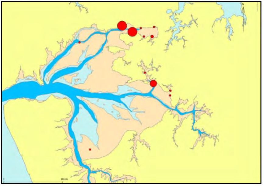
 Ann’s Creek
Figure 9 Relative abundance of the shellfish Austrovenus stutchburyi (
Ann’s Creek
Figure 9 Relative abundance of the shellfish Austrovenus stutchburyi (
ACT
ARC
2009). Relative abundance is represented by the size of the circles
Shorebirds
The Manukau Harbour contains extensive sand and mud flats which provide a rich food
resource for a range of shore birds including nationally and internationally important species.
The Manukau Harbour has been reported by ARC (2009) as being a national ‘hotspot’ for bird
diversity in coastal and wetland habitats with a high number of endemic and native species
using the harbour for foraging and breeding habitat. In terms of significance, the Manukau
Harbour has been reported to support over 20% of the total New Zealand wader population with
potentially more than 60% of all New Zealand waders using the harbour on a temporary basis
(ARC 2009). As well as being nationally important, the harbour is also an internationally
recognised area for a range of Northern Hemisphere waders that use the harbour as a foraging
INFORMATION
site during summer. Common Northern Hemisphere migrants to the Manukau Harbour include:
Bar-tailed
godwits.
Lesser
knots.
RELEASED UNDER THE
Turnstones.
Pacific golden plovers.
Eastern
curlews.
OFFICIAL
Red-necked
stints.
Sharp-tailed
sandpipers.
Whimbrels.
Curlew
sandpipers.
Mangere Inlet is considered an important roosting and feeding habitat for shorebird species
because of its value as a bird roosting and foraging area. Because of this the value of the area
has been recognised through designation of CPAs and areas of significant conservation value
in order to protect the identified foraging and roosting areas (ASCV) (ARC 2009; Figure 3; Table
3). Of those bird species known to frequent the wider Manukau Harbour 48 of these species
also frequent the Mangere Inlet area (Appendix C). As reported in ARC (2009) 15 of these
species have been classified as threatened by Hitchmough et al (2007) with 7 species having
threat codes2 1, 2 or 3 (Table 5). While no bird records were available for Ann’s Creek it is
possible that the species listed in Table 5 forage on the intertidal mudflats and roost in the
mangroves adjacent to the Creek.
Table 5 Threatened birds recorded within the Mangere Inlet (ARC 2009)
Common Name
Latin Name
Origin
Threat Status
All black stilt and pied stilt
Himantopus spp
Endemic
1
Brown Teal
Anas aucklandica chlorotis
Endemic
2
Grey duck
Anas superciliosa superciliosa
Native
2
New Zealand dotterel
Charadrius obscurus
Endemic
3
Caspian Tern
Sterna caspia
Native
3
Reef heron
Gretta sacra sacra
Native
3
ACT
Wrybill
Anarhynchus frontalis
Endemic
3
Fish
The Manukau Harbour is an important area for recreational and commercial fisheries with
species including grey mullet, flatfish, rig, kahawai, trevally, yellow eyed mullet, parore, red
gurnard and snapper caught within the main harbour and sheltered embayments. As reported
by ARC (2009) the Manukau Harbour is a particularly important area for the grey and yellow
eyed mullet fisheries, with around 25% of the national commercial catches coming from the
harbour. Recreational fishing is also carried out on structures providing good over water access
such as the old Mangere Bridge in Mangere Inlet. Other fish species recorded from within the
Manukau Harbour by NIWA (NIWA research project CO1X0022/25) and likely to occur within
the Mangere Inlet are listed in Table 6.
INFORMATION
Surveys investigating fish species and numbers within the intertidal to low tide sand and
mudflats in the Manukau Harbour were carried out by Morrison et al (2005) and found that
Mangere Inlet had the highest counts of yellow eyed mullet and sand flounder. In total, 7
species of fish were recorded from one site within Mangere Inlet and it is probable that these
RELEASED UNDER THE
species would also frequent the sheltered creeks such as Ann’s Creek for foraging or breeding.
Table 6 Fish species recorded from within the Manukau Harbour
Common Species Name
Scientific Species Name
OFFICIAL
Marine straggler
Blue warehou
Seriolella brama
Barracouta
Thyrsites atun
Kingfish
Seriola lalandi
Marine migrants (opportunistic/dependent)
Snapper
Chrysophrys auratus
2 Threat code 1 equates to nationally critical, 2 nationally endangered and 3 nationally vulnerable
Common Species Name
Scientific Species Name
Kahawai
Arripis trutta
Trevally
Pseudocaranx dentex
Yellow-eyed mullet
Aldrichetta forsteri
Various small sharks
Various species
Anchovies
Engraulis australis
Sprats
Various fish species including Sardinops neopilchardus
Pilchards
Sardinops sagax
Garfish (piper)
Hyporhamphus ihi
NZ Jack mackerel
Trachurus novaezelandiae
Snake eels (3 species)
Various species
ACT
Ahuru
Auchenoceros punctatus
Estuarine Species (resident/migrant)
Grey mullet
Mugil cephalus
Sand and yellow-belly flounder
Rhombosolea plebeian
Estuarine triplefin
Grahamina sp.
Sole
Peltorhamphus novaezeelandiae
Graham’s gudgeon
Grahamichthys radiata
INFORMATION
Freshwater migrants
Smelt
Retropinna retropinna
Marine cetaceans
RELEASED UNDER THE
While we acknowledge Maui’s dolphin is known to frequent the Manukau Harbour it is unlikely
that individuals will be found within the Mangere Inlet as the majority of individuals have been
recorded within the wider harbour and in open waters between the Manukau Harbour and Port
Waikato (Thompson et. Al., 2000, DeMaster et. Al., 2001, www.forestandbird.org.nz). Therefore
OFFICIAL
we will not discuss Maui’s dolphin further in this report.
Pinnepeds
Pinnipeds are a group of mammals consisting of aquatic mammals including seals, walruses
and similar animals with finlike flippers. In New Zealand there are four species of seal that
inhabit our coastal waters, including:
New Zealand sea lion (
Phocarctos hookeri);
New Zealand fur seal (
Arctocephalus fosteri);
Leopard seal (
Hydrurga leptonyx); and
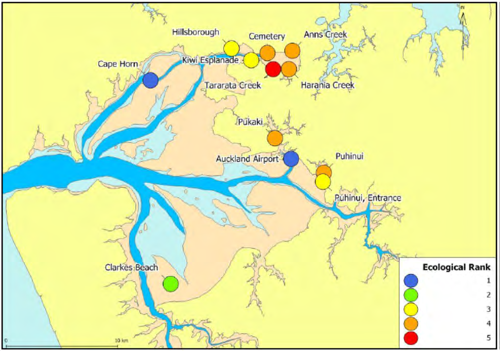
Elephant seal (
Mirounga leonine).
Of these pinnipeds, the species most likely to occur within the marine and intertidal areas of the
project area is the New Zealand fur seal. Fur seals are found on coastal shores around New
Zealand, including the Chatham Islands and the sub-Antarctic islands (including Macquarie
Island). While named the New Zealand fur seal, the species is also found in South Australia,
Western Australia and Tasmania.
Arctocephalus fosteri represents the most common seal
species in New Zealand.
The EWC project will require localised coastal development within the coastal zone. There was
no published information available at the time of writing on the distribution of pinnipeds within
the Manukau Harbour. It is possible that individuals may occasionally occur in the project area.
Ecological Condition of Mangere Inlet
The ecological condition of the Manukau Harbour has been a focus of Auckland Council state of
the environment (SoE) monitoring which started in 1987 by the Auckland Regional Water Board
(a precursor to the Auckland Regional Council (ARC)). The majority of the SoE sampling sites
were located in the main body of the harbour where sediment bound contaminants do not tend
to accumulate due to tidal and hydrodynamic forces. To account for this, the ARC established
ACT
the Stormwater Contaminant Monitoring Programme to monitor concentrations of key sediment
contaminants in more susceptible parts of the harbour, including Mangere Inlet (AC 2009).
Results of the programme found that the condition of ecological communities in high
depositional environments and tidal creeks of Mangere Inlet were degraded, with the community
at Tararata Creek having the worst condition (health rank = 5) (Figure 10). Benthic communities
recorded from Mangere Cemetery, Ann’s Creek and Harania Creek were only slightly better with
a health rank of 4 (Figure 10).
INFORMATION
RELEASED UNDER THE
OFFICIAL
Figure 10 Ecological condition of benthic communities in Manukau Harbour.
Condition is ranked from 1 (blue = healthy) to 5 (red = degraded)
(ARC 2009)
Other Activities Surrounding Mangere Inlet
The Mangere Inlet is the site of many light and heavy industrial activities that discharge directly
or indirectly to the Inlet and which may have environmental impacts. Although no quantification
of these impacts is presented in this report it would be logical to assume that the discharges
could have an impact on the Inlet and wider Manukau Harbour.
Mangere Inlet has seen extensive changes in land-use over the past 170 years with the area
surrounding the inlet developed as Auckland’s agricultural centre in the 1850’s through to urban
and industrial development in the 1900’s; and which is still expanding today (ARC 2009). All
these land-uses have contributed contaminants leading to environmental degradation of the
Mangere Inlet, including:
Leachate from various refuse tips.
Cemetery.
Glass
production.
Ports of Auckland.
Westfield
railway
yards.
ACT
Southdown
Power
Station.
Mainfreight.
Pacific
Steel.
Terrestrial Sites of Significance
An assessment of the terrestrial sites within the EWC alignment project area identified two sites
of significance, namely Southdown Reserve and Hamlins Hill.
Hamlins Hill – Mutukaroa
Hamlins Hill – Mutukaroa is a 48ha regional park located in Mt Wellington and administered by
Auckland Council as a regional park and is the largest and most prominent non-volcanic
INFORMATION
geological feature in Auckland City (Figure 11).
The park is located in the middle of a highly modified urban and light industrial area and is still
used to graze cattle with limited mature native vegetation (Figure 11). However, bush
restoration has been carried out over the past 10 years by Forest and Bird and other volunteer
RELEASED UNDER THE
organisations and these areas are now providing habitat and a food resource for native bird
species. While the park does not have any permanent freshwater streams it is likely to have
ephemeral streams particularly during the winter months. We recommend surveying the site for
the presence of permanent or ephemeral streams and where appropriate carry out instream
surveys prior to construction.
OFFICIAL
Hamlins Hill is predominantly pasture with a gully on the northern side vegetated with some
scrubby native vegetation. A visual inspection of the available high level plans and imagery
indicates the gully may be ephemeral running towards the existing motorway. The Option B
alignment is expected to require a cut into the Hamlins Hill park of approximately 30m in width
but given the proposed cut area is predominantly pasture we expect the ecological effects to
low. Further assessment of the area depending on the preferred alignment is recommended to
confirm this.
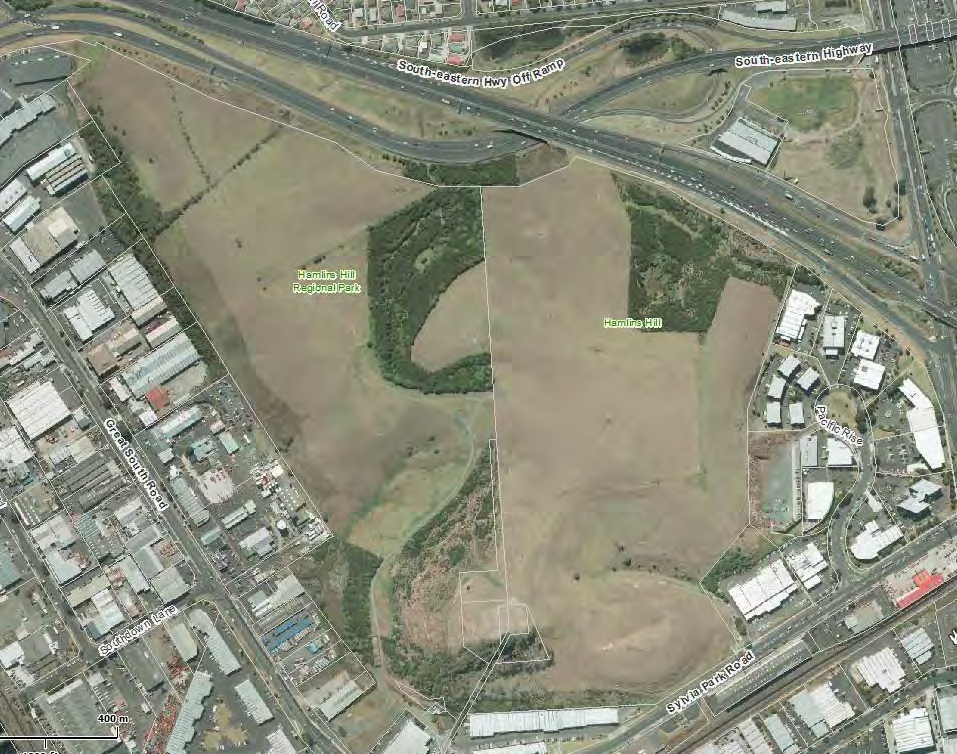
 Hamlins Hill
Regional Park
ACT
Figure 11 Location of Hamlins Hill – Mutukaroa Regional Park
8.1.1 Southdown Reserve
This section comprises a high level qualitative discussion of the Southdown Reserve only as no
information was available discussing the ecological significance of the site. However, based on
INFORMATION
aerial imagery, the Southdown Reserve (located adjacent to the Southdown Power Plant and
bounded by the Westfield Railway) is disconnected from the surrounding coastal marine area
and other neighbouring reserve sites and therefore reduces the ability of species such as birds
and reptiles to utilise this site as a foraging or roosting area.
RELEASED UNDER THE
OFFICIAL
Appendix B – CPA and ASCV sites within the Tamaki
Estuary (ARC 2008)
Protection Type
CPA/ASCV
Description
Number
Coastal Protection Area 2
44
Waiouru Tuff Mound
A waiouru Tuff Mound, often incorrectly referred to as Pukekiwiriki, is an
indistinct, crater-like depression about 300m in diameter. The crater is
breached to the SW by tidal creeks and has an eight metre terrace along
the Tamaki River. One of the oldest members of Auckland Volcanic Field,
this geological landform is considered to be regionally important.
Coastal Protection Area 1
45a and b
Pakuranga Creek and Roost
Pakuranga Creek roost (45a) is one of the roosting sites used by some of
the hundreds of wading birds that feed within the Tamaki Estuary. The
ACT
whole of the Tamaki Estuary is a regionally important wildlife habitat and
has been selected by the Department of Conservation as an Area of
Significant Conservation Value (ASCV). This roost is associated with the
values of Coastal Protection Areas 47, 48 and 49 and forms an integral part
of the wildlife habitat values of the estuary. The mangrove areas of
Pakuranga Creek (45b) are regarded as the best example of mangrove
habitat in the Tamaki Estuary.
Coastal Protection Area 2
46/62
Panmure Basin Explosion Crater
and Area of Significant
An explosion crater and associated tuff ring that is naturally breached to
Concervation Value
form a tidal lagoon. This landform is still relatively complete and is
considered to be regionally important. The Department of Conservation has
selected this area as an Area of Significant Conservation Value (ASCV).
INFORMATION
Coastal Protection Area 1
47
Tamaki River East Roost
One of the roosting sites used by some of the hundreds of wading birds that
feed within the Tamaki Estuary. This roost is associated with the values of
RELEASED UNDER THE
Coastal Protection Areas 45, 48 and 49.
Coastal Protection Area 2
48/61
Tamaki East Bank
and Area of Significant
This intertidal bank is a feeding ground for the hundreds of wading birds
Conservation Value
that use the Tamaki Estuary. This feeding ground is associated with the
OFFICIAL values of Coastal Protection Areas 45, 47 and 49. This area also includes
part of the Farm Cover ignimbrite, most of which is above mean high water
spring (MHWS).
Coastal Protection Area 2
49a – d
Tahuna Torea to Point England
and Area of Significant
and 60
The spit and associated northern and southern intertidal banks, together
Conservation Value
comprise a wildlife habitat of regional importance. This area is associated
with the value of Coastal Protection Areas 46, 47 and 48. At Point England
(49b) is a small geological exposure of rhyolitic co-ignimbritic accretionary
lapilli from the Taupo Volcanic Zone, which is exposed as a thin bed near
the base of an eroded low sea cliff. The site is considered to be nationally
Protection Type
CPA/ASCV
Description
Number
important and has been selected by the Department of Conservation as an
Area of Significant Conservation Value (ASCV).
Coastal Protection Area 1
50a and b
Musick Point
Two exposures in the cliffs and intertidal platforms are considered to be
geologically important. One (50b) is an over thrust fold involving flysch beds
and the other (50c) is the best example in the region of an anticline visible
in three dimensions. Both of these geological features are considered to be
regionally important.
Area of Significant
79
No Information
Conservation Value
ACT
INFORMATION
RELEASED UNDER THE
OFFICIAL
Appendix C – Manukau Harbour Bird Species List
Common Name
Latin Name
Origin
Threat Status
All black stilt and pied stilt
Himantopus spp
Endemic
1
Asiatic black-tailed godwit
Limosa limosa melanuroides
Straggler
Australasian little grebe
Tachybaptus novaehollandiae novaehollandiae
Native
Australasian pied stilt
Himantopus himantopus leucocephalus
Native
Autralasian gannet
Morus serrator
Native
Banded dotterel spp
Charadrius bicinctus spp
Endemic
5
Black billed gull
Larus bulleri
Endemic
4
Black fronted dotterel
Charadrius melanops
Native
ACT
Black shag
Phalacrocorax carbo novaehollandiae
Native
6
Black stilt
Himantopus novaezelandiae
Endemic
1
Black swan
Cygnus atratus
Introduced
Brown Teal
Anas aucklandica chlorotis
Endemic
2
Canada Goose
Branta 51orphyria51 maxima
Introduced
Caspian Tern
Sterna caspia
Native
3
Cattle egret
Bubulcus ibis coromandus
Migrant
Eastern bar-tailed godwit
Limosa lapponica baueri
Migrant
INFORMATION
Feral goose
Anser anser
Introduced
Fluttering shearwater
Puffinus gavial
Endemic
RELEASED UNDER THE
Grey duck
Anas superciliosa superciliosa
Native
2
Lesser knot
Calidris canutus canutus
Migrant
Little black shag
Phalacrocorax sulcirostris
Native
7
OFFICIAL
Little shag
Phalacrocorax melanoleucos brevirostris
Endemic
Mallard
Anas platyrhynchos platyrhynchos
Introduced
New Zealand dabchick
Poliocephalus rufopectus
Endemic
6
New Zealand dotterel
Charadrius obscurus
Endemic
1
New Zealand Kingfisher
Halcyon sancta vagans
Native
New Zealand Scaup
Aythya novaeseelandiae
Endemic
Common Name
Latin Name
Origin
Threat Status
New Zealand shoveler
Anas rhynchotis variegata
Endemic
Pacific golden plover
Pluvialis fulva
Migrant
Paradise Shelduck
Tadorna variegate
Endemi
Pectoral Sandpiper
Calidris melanotos
Sraggler
Pied shag
Phalacrocorax varius varius
Native
Pukeko
Porphyrio 52orphyria melanotus
Native
Red billed gull
Larus novaeholladiae scopulinus
Endemic
5
Red necked stint
Calidris ruficollis
Migrant
Reef heron
Gretta sacra sacra
Native
3
Royal spoonbill
Platalea regia
Native
ACT
Siberian tattler
Tringa brevipes
Straggler
Sooty shearwater
Puffinus griseus
Native
South Island pied
Haematopus ostralegus finschi
Endemic
oystercatcher
Southern Black-backed gull
Larus dominicanus dominicanus
Native
Spotted shag spp
Stictocarbo punctatus punctatus
Endemic
Spur-wing plover
Vanellus miles novaehollandiae
Native
Turnstone
Arenaria interpres
Migrant
INFORMATION
Variable oystercatcher
Haematopus unicolor
Endemic
White faced heron
Ardea novaehollandiae novaehollandiae
Native
RELEASED UNDER THE
White Fronted tern
Sterna striata
Native
5
Wrybill
Anarhynchus frontalis
Endemic
3
OFFICIAL

ACT
GHD
Level 3, 27 Napier Street
INFORMATION
Freemans Bay
T: 64 9 370 8000 F: 64 9 370 8001 E: [email address]
© GHD Limited 2014
RELEASED UNDER THE
This document is and shall remain the property of GHD. The document may only be used for the
purpose for which it was commissioned and in accordance with the Terms of Engagement for the
commission. Unauthorised use of this document in any form whatsoever is prohibited.
G:\51\32651\Technical\Environment\Ecology\EWC template\Working Draft\Template for Expert
Assessments_Ecological Assessment_22102014 - FINAL.docx
OFFICIAL
Document Status
Rev Author
Reviewer
Approved for Issue
No.
Name Signature
Name
Signature
Date
0
L. Hack
J. Matthews
08/10/2014
1 L.
Hack
M.
Wallis
16/10/2014
2 L.
Hack
M.
Wallis
21/10/2014
3 L.
Hack
M.
Wallis
5/11/2014

ACT
www.ghd.com
INFORMATION
RELEASED UNDER THE
OFFICIAL