
Attachment D
East West Connections Report
Options shortlisting – preliminary groundwater
assessment
Prepared for NZTA and Auckland Transport
THE ACT
Prepared by Beca Ltd
UNDER
INFORMATION
RELEASED
OFFICIAL
THE ACT
UNDER
INFORMATION
RELEASED
OFFICIAL

[Document title]
Executive Summary
The East West Connections project is a joint NZ Transport Agency and Auckland Transport programme to
improve freight efficiency, commuter travel, public transport and walking and cycling options over the next 30
years in the area between Onehunga, Penrose, East Tamaki and Auckland Airport. Six options were short-
listed for the Onehunga-Penrose connection (a description of each is held in the Detailed Business Case):
Option A (Long List Option 1): Existing route upgrade
Option B (Long List Option 2): Upgrade with South Eastern Highway Ramp
Option C (Long List Option 5): Upgrade with new Galway Street and inland connections
Option D (Long List Option 8): Upgrade with Gloucester Park interchange and new Galway St and inland
connections
Option E (Long List Option 13): New foreshore connection
Option F (Long List Option 14): New foreshore and inland connection.
This report provides a high level assessment of the effects of the each of the six options on groundwater
levels and flow. Groundwater quality is addressed in a separate assessment.
THE ACT
Existing groundwater levels and flow may be influenced by the project if there are changes to surface water
flows and infiltration, where earthworks and subsurface construction require drainage or take place below the
seasonal low groundwater level, and where changes to soil permeability occur. A rise or lowering of
groundwater level as a consequence of cut or fill construction has the potential to affect:
Groundwater levels (cause more frequent surface flooding or drawdown induced ground settlement;
reduced recharge to water supply wells and/or saline intrusion)
UNDER
Existing stream levels/ springs
Groundwater flow directions (altered discharge to streams or coast)
The fresh water/ salt water interface
The migration of contaminants that may be present in groundwater.
Groundwater flow and levels are largely controlled by the ground conditions (soil and rock permeability and
INFORMATION
layering) and topography (ground elevation and slope, streams and the coastline). A preliminary 3D ground
model was developed using existing borehole and groundwater well data with reference to published
geological maps. The potential for the above effects to occur was assessed by identifying the proposed cut
and fill elements of the options in relation to the ground model. A groundwater flow model was not prepared
as part of this high level assessment.
RELEASED
The assessment found that the project is unlikely to have significant effects on groundwater:
Options A and B are expected to have nil or less than minor effects
Option C is likely to have a less than minor effect provided fills placed over existing fill are constructed on
OFFICIAL
a granular drainage blanket (or similar)
The minor to potentially moderate effects of Options D, E and F can be resolved through engineered
solutions, however these will present some challenges. Of these, Option E is preferred because it avoids
crossing Miami stream and maximises the length of embankment on the seaward side of the foreshore
area (i.e. does not cross the existing foreshore landfill area).
If construction is to take place in the Mangere Inlet, construction of the road embankment set back from the
toe of the existing foreshore, allowing access to the sea from beneath a bridge beyond Pikes Point would
allow existing groundwater flow and discharge to be maintained and the effects on groundwater would be
negligible.
20/08/2014/ /Page | ii

[Document title]
Contents
1 Introduction 1
2 Methodology of the Assessment
4
2.1
Groundwater Effects Overview
4
2.2
Assessment Methodology
4
3 Background Information
5
3.1
Reliance
5
3.2
Ground Conditions
5
3.3
Groundwater Conditions
7
3.4
Elements Considered
8
4 Key Design Assumptions
10
THE ACT
5 Assessment of Effects on Groundwater
12
5.1
Assessment of Option A (1)
12
5.2
Assessment of Option B (2)
12
5.3
Assessment of Option C (5)
13
5.4
Assessment of Option D (8)
13
UNDER
5.5
Assessment of Option E (13)
14
5.6
Assessment of Option F (14)
15
6 Recommended Mitigation Required
16
6.1
Options A and B
16
6.2
Option C
16
INFORMATION
6.3
Option D
16
6.4
Option E
17
6.5
Option F
17
7 Conclusion and Recommendation
18
RELEASED
8 References 19
Appendices
OFFICIAL
Appendix A: Summary of Groundwater Borehole Data
20/08/2014/ /Page | iii

[Document title]
1 Introduction
The East West Connections project is responding to the immediate and growing freight access issues at
either end of the Neilson Street/Church Street corridor caused by inefficient transport connections and a lack
of response to changes in the industry’s supply chain strategies. The project is also addressing the
inadequate quality of transport choices between Māngere, Ōtāhuhu and Sylvia Park.
The long list of options was developed in a 2-stage process. The option identification process began with
identifying changes at a component level (e.g. lane widening; interchange improvements) across the
geographical area. To ensure a full spectrum of components was considered, the study area was separated
into segments. All components were then assessed through a multi-criteria analysis. Where broadly
equivalent components (in terms of either transport performance or social, environmental or cultural
outcomes) were identified, the best alternative proceeded to the development of the long list options. If no
broadly equivalent alternative component existed, the component was progressed to the development of
long list options. All options were assessed through a multi-criteria analysis, which considered a full range of
impacts and performance against the project’s objectives and the East West Connections outcomes. Six
THE ACT
options were identified to progress to the short list for the Onehunga-Penrose connection. These options
range from low investment to high investment.
These 6 options are the subject of this assessment and a detailed description of each is held in the Detailed
Business Case. The following summarised descriptions have been used as the basis for the following
assessment of effects on groundwater.
Option A (Long List Option 1): Existing route upgrade
UNDER
This option looks to upgrade the existing roads. This includes improving capacity on
SH20, Neilson Street and Church Streets. It also provides freight lanes.
Auxiliary lanes / capacity improvements on SH20 (Queenstown Road to Gloucester Park)
Some widening of Onehunga Harbour Road at Gloucester Park (e.g. around the Onehunga Port area,
beneath SH20 and potential to increase this from 2 to 3 lanes up to Neilson Street / Onehunga Mall
INFORMATION
intersection).
Upgrading of the intersection at Onehunga Mall / Neilson Street intersection (potentially including
widening of bridge over the rail line) to provide for dedicated movements between Onehunga Mall /
Neilson Street.
Capacity improvements on Neilson St, for example extending the 4-laning from Alford St to Church St
RELEASED
(potential impact on some road frontages, but looking to minimise)
New signalised intersection to provide access to Metroport (for example, providing for dedicated turning
median).
Cycleway uses Hugo Johnston Road (within the road corridor), may impact on tree planting etc in existing
road reserve, will then connect to Church Street East and Great South Road (level crossing) to connect to
OFFICIAL
existing cycle path to Sylvia Park.
Freight lane priority at Mt Wellington Interchange where this can fit beneath existing bridge constraints.
Option B (Long List Option 2): Upgrade with South Eastern Highway Ramp
This option proposes an upgrade of existing roads with new ramp connections from Church Street to SH1
and South Eastern Highway.
Auxiliary lanes / capacity improvements on SH20 (Queenstown Road to Gloucester Park).
20/08/2014/ /Page | 1

[Document title]
Some widening of Onehunga Harbour Road at Gloucester Park is likely (e.g. around the Onehunga Port
area, beneath SH20 and potential to increase this from 2 to 3 lanes up to Neilson Street / Onehunga Mall
intersection.
At Onehunga Mall / Neilson Street intersection, upgrading of intersection is required (potentially including
widening of bridge over the rail line) to provide for dedicated movements between Onehunga Mall /
Neilson Street.
Looking at capacity improvements on Neilson St, for example extending the 4-laning from Alford St to
Church St (potential impact on some road frontages, but looking to minimise).
New signalised intersections and upgrades to intersections at Metroport (for example: providing for a
dedicated turning median), Church St, Hugo Johnston Drive and Great South Road (grade separation at
Hugo Johnston Drive and Great South Road may be considered).
Cycleway using Hugo Johnston Road (within the road corridor), may impact on tree planting etc in
existing road reserve, will then connect to Church Street East and Great South Road (level crossing) to
connect to existing cycle path to Sylvia Park.
New connections for ‘southern’ traffic on SH1, with ramps from the South Eastern Arterial (looking at
ramps of 2-lanes in each direction to connect from interchange to tie in with SH1 at Mt Wellington). This
requires an auxiliary lane extension on SH1 down to Princes Street interchange.
THE ACT
Option C (Long List Option 5): Upgrade with new Galway Street and inland connections
This option proposes a new connection from Onehunga Harbour Road to Galway Street, and upgrade of
Neilson and Angle Streets and Sylvia Park Road, and a new connection for Angle Street to Sylvia Park Road
and to SH1.
Auxiliary lanes / capacity improvements on SH20 (Queenstown Road to Gloucester Park)
UNDER
Some widening of Onehunga Harbour Road at Gloucester Park is likely (e.g. around the Onehunga Port
area, beneath SH20.
New connection from Onehunga Harbour Road onto Galway Street (may impact on traffic movements /
access to SH20 from Onehunga Mall / Onehunga Harbour Road)
4-lanes on Galway Street with upgraded intersection to Neilson Street, upgrading of intersection required
(potentially including widening of bridge over the rail line) and to address increased traffic from Onehunga
Mall to Galway Street.
INFORMATION
Looking at capacity improvements on Neilson St, for example extending the 4-laning from Alford St to
Angle St and upgrading of Angle Street (e.g. up to 4-lane, which may require some additional land).
New connection from Angle Street to Great South Road for between 2 and 4 lanes, and where practicable
on land between Transpower towers and foreshore (not reclamation).
RELEASED
At Sylvia Park Road, increasing capacity of some of Sylvia Park Road (e.g. additional lanes) and may
require land take and relocation of Transpower towers.
Ramps over Mt Wellington Highway to connect onto SH1, serving the south, with increased capacity (e.g.
auxiliary lanes) on SH1 down to Princes St.
Waikaraka Cycleway maintained and extended alongside new road sections to connect to Sylvia Park.
OFFICIAL
Option D (Long List Option 8): Upgrade with Gloucester Park interchange and new Galway St and
inland connections
This option proposes an upgrade at Gloucester Park Interchange and a new connection from Onehunga
Harbour Road to Galway Street. It also proposes an upgrade of Neilson and Angle Streets and Sylvia Park
Road, and a new connection for Angle Street to Sylvia Park Road and to SH1.
Auxiliary lanes / capacity improvements on SH20 (Queenstown Road to Gloucester Park).
New interchange at SH20 at Gloucester Park, to restrict access to Neilson Street and divert all traffic onto
Onehunga Harbour Road (widening requirements for Onehunga Harbour Road, e.g. 3+ lanes).
20/08/2014/ /Page | 2

[Document title]
New connection from Onehunga Harbour Road onto Galway Street (may impact on traffic movements /
access to SH20 from Onehunga Mall / Onehunga Harbour Road).
4-lanes on Galway Street with upgraded intersection to Neilson Street, upgrading of intersection required
(potentially including widening of bridge over the rail line) and to address increased traffic from Onehunga
Mall to Galway Street.
Looking at capacity improvements on Neilson St, for example extending the 4-laning from Alford St to
Angle St and upgrading of Angle Street (e.g. up to 4-lane, which may require some additional land).
New connection from Angle Street to Great South Road for between 2 and 4 lanes, and where practicable
on land between Transpower towers and foreshore (not reclamation).
At Sylvia Park Road, increasing capacity of some of Sylvia Park Road (e.g. additional lanes) and may
require land take and relocation of Transpower towers.
Ramps over Mt Wellington Highway to connect onto SH1, serving the south, with increased capacity (e.g.
auxiliary lanes) on SH1 down to Princes St.
Waikaraka Cycleway maintained and extended alongside new road sections to connect to Sylvia Park.
Option E (Long List Option 13): New foreshore connection
This option proposes a new connection from SH20 to SH1 along the foreshore.
THE ACT
Auxiliary lanes / capacity improvements on SH20 (Queenstown Road to Gloucester Park).
New interchange at SH20 at Gloucester Park, with access to Neilson Street and onto Onehunga Harbour
Road (may require some changes to traffic movements from Onehunga Harbour Road onto SH20).
New connection from Gloucester Park along foreshore to Great South Road, with local connections at
Captain Springs Road, Southdown (Metroport) and Great South Road to connect (via intersection) onto
Vesty Drive.
UNDER
New bridge from Vesty Road to provide new ramp connection to SH1 at Panama Road (between
businesses and residential areas).
New ramp connections at Panama Road (potentially requiring replacement of Panama Road Bridge) with
increased capacity (e.g. auxiliary lanes) on SH1 down to Princes St.
Waikaraka Cycleway maintained and extended alongside new road sections to Great South Road and
then onto alignment around Hamlin’s Hill.
INFORMATION
Option F (Long List Option 14): New foreshore and inland connection
This option proposes a new connection form SH20 to SH1 (partly along the foreshore and partly inland).
Auxiliary lanes / capacity improvements on SH20 (Queenstown Road to Gloucester Park).
RELEASED
New interchange at SH20 at Gloucester Park, with access to Neilson Street and onto Onehunga Harbour
Road (may require some changes to traffic movements from Onehunga Harbour Road onto SH20).
New connection from Gloucester Park along foreshore to Captain Springs Road and then inland to Great
South Road.
New intersections at Captain Springs Road, Southdown (Metroport) and Great South Road (may require
OFFICIAL
relocation of Transpower towers).
At Sylvia Park Road, increasing capacity of some of Sylvia Park Road (e.g. additional lanes) and may
require land take and relocation of Transpower towers.
Ramps over Mt Wellington Highway to connect onto SH1, serving the south, with increased capacity (e.g.
auxiliary lanes) on SH1 down to Princes St.
Waikaraka Cycleway maintained and extended alongside new road sections to connect to Sylvia Park.
20/08/2014/ /Page | 3

[Document title]
2
Methodology of the Assessment
2.1
Groundwater Effects Overview
Existing groundwater levels and flow may be influenced by the proposed development if there are changes
to surface water flows and infiltration, where earthworks and subsurface construction require drainage or
take place below the seasonal low groundwater level, and where changes to soil permeability occur. These
potential effects are set out below:
Cuts extending below the groundwater table that require drainage and lowering of groundwater levels
extending beyond the cut
Filling on compressible ground that results in consolidation of the ground beneath the water table and
consequent reduction in its hydraulic conductivity. This may cause a rise of groundwater level on the up-
gradient side of the constructed fill embankment and a lowering of groundwater level on the down-
gradient side of the embankment
Filling adjacent to or over a groundwater discharge area resulting in a rise of groundwater level up-
THE ACT
gradient and reduction in discharge down-gradient
Reduction in aquifer recharge by constructing a pavement over an aquifer recharge area.
A rise or lowering of groundwater level as a consequence of cut or fill construction has the potential to affect:
Groundwater levels (cause more frequent surface flooding or drawdown induced ground settlement;
reduced recharge to water supply wells and/or saline intrusion)
Existing stream levels/ springs
UNDER
Groundwater flow directions (altered discharge to streams or coast)
The fresh water/ salt water interface
The migration of contaminants that may be present in groundwater.
2.2
Assessment Methodology
Groundwater flow and levels are largely controlled by the ground conditions (soil and rock permeability and
INFORMATION
layering) and topography (ground elevation and slope, streams and the coastline). A preliminary 3D ground
model was developed using the available existing geotechnical borehole and groundwater well data
(Appendix A) with reference to published geological maps (Kermode & Searle 1966, Kermode 1992).
Groundwater level data obtained from Auckland Council and from Beca projects for NZTA was then
RELEASED
introduced to the ground model. A groundwater flow model has not been prepared as part of this high level
assessment.
The potential for the above effects to occur was assessed by identifying the proposed cut and fill elements of
the options in relation to the ground model. The ground model will need to be incorporated into a finite
OFFICIAL
element groundwater flow model to assess in more detail the effects of the finally selected option to both
support mitigation through design and consenting.
20/08/2014/ /Page | 4

[Document title]
3
Background Information
3.1 Reliance
This assessment was informed by and relies upon other technical assessments prepared in support of the
Project, including the following:
Assessment of Surface Water and Stormwater effects
Assessment of Land and Groundwater Contamination effects
Shortlist options layout plans.
3.2 Ground
Conditions
The area is underlain by the Manukau Lava Field built largely by lava flows from One Tree Hill and Mount
Smart volcanoes, but also from Mt Wellington volcano in the east. Mt Smart volcano is the oldest of these
(38,000 years) and is understood to have erupted on a pre-existing land surface that is now well below sea-
THE ACT
level in the mouth of a valley system. The Hopua explosion crater (Gloucester Park) comprises an elevated
tuff1 ring that erupted some 34,000 years ago. When sea-level rose, the tuff ring was breached and marine
and organic muds were deposited within. The breach was closed some 70 years ago and the ruff ring
reclaimed with both urban refuse and fill. The basalt lava and tuff overlie and are locally interbedded with a
variable thickness of Tauranga Group alluvium, comprising pumiceous silt, sand and gravel with muddy peat
and non-welded and alluvially reworked ignimbrite and tephra.
The Onehunga Bay and Manukau Inlet foreshore has been progressively reclaimed with landfill and
UNDER
engineered fill. The volcanics are bound to the east by an uplifted block of Waitemata Group sandstone and
siltstone, although some lava and tuff from Mt Wellington volcano have flowed around the block from the
north-east in the area of Ann’s Creek. The geology is described in more detail in Beca (2014). An image of
the ground model and a typical cross-section are shown in Figure 1.
INFORMATION
RELEASED
OFFICIAL
1 Tuff is compacted volcanic ash and debris varying in size from fine sand to coarse gravel and often
stratified
20/08/2014/ /Page | 5

[Document title]
THE ACT
UNDER
INFORMATION
N
S
)
(m
RELEASED
RL
OFFICIAL
Figure 1:
Upper: Terrain in the ground model area showing the envelope of options (orange and black lines).
Middle: Image from the 3D
ground model. Pink colours indicate tuff and basalt flows from One Tree Hill volcano, reds from the Mt Smart volcano, green and indigo,
from Hopua volcano. These basalt aquifers overlie and are locally intercalated with Tauranga Group alluvium (yellow) and overlie
Waitemata Group sandstone and siltstone which forms the basement rocks in the area (orange). Areas of fill are indicated in grey.
Lower: North – South cross-section (section line shown in upper image); groundwater level indicated approximately by blue dashed line.
20/08/2014/ /Page | 6

[Document title]
3.3 Groundwater
Conditions
3.3.1 Hydrogeological
units
The basalt lava flows are complex, being locally fractured, rubbly and cavernous and blocked by or over-
riding earlier flows and in some places, Tauranga Group alluvium. This means that the hydraulic conductivity
can vary by orders of magnitude over short distances, both horizontally and vertically (K = 1 x 10⁻³ m/s to 5 x
10-6 m/s).
Groundwater flow through the basalts and tuffs is expected to generally follow topography toward the
Manukau Inlet, but actual flow paths may be quite sinuous according to variations in hydraulic characteristics
of the lava flows. Vertical flow is constrained by the underlying lower permeability Tauranga Group alluvium
and Waitemata Group rocks. Waitemata Group rock rises to the surface at Hamlin Hill, which forms a lateral
barrier to groundwater flow. Groundwater flow may be concentrated through lava flows that occupy paleo-
valleys. Flow is inferred to be to the northeast below Ann’s Creek from at least the vicinity of the
Mt Wellington Highway along the historic Wellington valley beneath Ann’s Creek towards Mt Wellington, but
broadly to the south through the One Tree Hill discharging via the eastern side of Hopua volcano and Te
THE ACT
Papapa, and Mt Smart volcanics, discharging beneath Pikes Point).
Typical values of hydraulic conductivity for the lower permeability Tauranga Group and Waitemata Group are
of the order of K = 10-7 m/s). Hydraulic conductivity of the fills (engineered and landfill) is expected to vary
over a wide range (K = 10-5 to 10-9 m/s) but is generally assumed to have a relatively low permeability (when
compared to that of the basalts).
3.3.2
Water levels and gradients
UNDER
The data available indicates that groundwater in the Onehunga area resides within lava flows derived from
the One Tree Hill and Mt Smart volcanoes at approximately 1.5 to 2 m RL (1.2 to 5.5 m below ground level
(bgl)). Water levels gradually rise towards the volcanic centres at a shallower rate than the topography with
groundwater levels of 3 to 5 m RL (1.5 to 9 m bgl) in the vicinity of Arthur St, some 8 m RL (13 to 14 m bgl) at
Grey St, and 28 m RL (6 m bgl) at Mt Smart Road. There is no data available to suggest perched water
levels in this area.
INFORMATION
URS (2010) identified two basalt aquifers in the Te Papapa area, separated by relatively impermeable
ash/tuff. The deeper basalt is thicker and more extensive than the shallow basalt and was interpreted to be
part of the Onehunga/ Mt Wellington aquifer system. The shallower basalt is thought to be less extensive
RELEASED
than the deep basalt and is only defined where tuff/ash occurs between the two basalt flows. Water levels of
7.0 to 7.5 m RL are recorded in the deeper aquifer in the Mays Rd/ Church St intersection area, dropping
steadily towards the southwest to around 2.5 m RL in the Neilson St area. Seasonal variation of up to 1 m
was observed in some of the boreholes. The shallow basalt aquifer was mostly dry, indicating intermittent
groundwater flow. OFFICIAL
The ground model developed from existing data as part of the current study (Figure 1) indicates the
presence of Tauranga Group alluvium between some flows, in particular in the east, which would also allow
a separate groundwater level to reside in the over and underlying flows.
Data for the Penrose area indicate groundwater levels at 4.2 to 9.5 m RL.
The ground model developed as part of the EWC project indicates groundwater gradients (the drop in
groundwater level with distance) of 0.007 to 0.03 (average of 0.02) above (north of) Church Street and of
0.001 to 0.006 (average of 0.003) below (south of) Church Street. These are comparable with the average
groundwater gradients reported by Earthtech (1993), which were also low (0.003 to 0.004).
20/08/2014/ /Page | 7

[Document title]
Earthtech (1993) reviewed groundwater levels in the area as part of an aftercare study for the Pikes Point
landfill. They reported landfill leachate levels were 0.3 m to 1.1 m above groundwater levels. However this is
likely to have been subsequently altered as a result of a leachate system implemented by Auckland Council
in May 1993. Land and groundwater contamination is discussed in the Land and Groundwater
Contamination effects assessment.
3.3.3 Saline
intrusion
The 2013 – 2014 annual report of water quality monitoring for the Pikes Point Closed Landfill prepared by
Envirowaste indicates that the composition of groundwater in the groundwater boreholes monitored is of the
order of 20% to 50 % seawater; however the locations of the boreholes referred to is not known.
None of the options as currently proposed are judged to negatively influence the current position of the
freshwater/ saltwater interface.
3.4 Elements
Considered
THE ACT
3.4.1 Springs
and
streams
Four surface water courses are known to occur in the project area:
Miami Stream (also referred to as Green Stream following a contamination incident; URS 2010)
Captain Springs: a groundwater fed spring that discharges into an open unlined channel and connects to
the reticulated stormwater system; the 1959 aerial photographs show a stream crossing the intertidal area
originating from discharges between Captain Springs Road and Angle Street
UNDER
Bycroft Stream: a wetland groundwater spring fed wetland system. The stream flows for some 100 m and
is then diverted into the reticulated stormwater system
Ann’s Creek.
Aerial photographs for 1951, 1955 and 1959 indicate meandering stream discharges through the tidal
alluvium originating:
INFORMATION
In land bound by Princes Street, Galway Street, Victoria Street and Neilson Street to the east of Hopua
volcano, aligned broadly North – South; more modern aerial photographs (2001, 2006 and 2008) indicate
a discharge from beyond the end of Galway Street into the harbour and from beyond the end of Victoria
Street (now likely to be stormwater discharges) and a number of less distinct discharges across the
RELEASED
foreshore (E side of Hopua volcano and Te Papapa); and
In land adjacent to Alfred Street, south of Neilson Street, aligned broadly east – west, joining the more
major north south discharge from south of Princes Street; discharges across the intertidal areas are
evident from the end of Alfred Street and multiple locations within 150 m east of Alfred Street (Pikes
Point).
OFFICIAL
These features have been filled over in the 1970’s and 80’s; however later aerial photographs continue to
show some indication of such discharges, but generally subdued and altered in appearance.
3.4.2 Water
supply
wells
Watercare owns and operates four wells in Onehunga which have historically provided part of Auckland
City’s water supply. Current consents require a minimum groundwater level in the sources of 0.5 m RL.
These consents are up for renewal in December 2015. The wells are located between Princes Street and
Church Street north of Gloucester Park (Figure 2) as follows:
20/08/2014/ /Page | 8

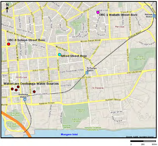
[Document title]
At the corner of Pearce St and Upper Municipal Place (the Pearce St well), at approximately RL 11.8 m
(well 12.3 m deep)
Within the Watercare Onehunga Treatment facility (the Rowe St well), at approximately RL 5 m (well
5.5 m deep)
At the back of the garage of the Onehunga Workingmen’s club (the Upper Municipal Place well), at
approximately RL 15.7 m (14.5 m deep); the well has not been operated since 2004
On the berm, next to the pavement on Lower Municipal Place (the Lower Municipal Place well), at
approximately RL 8 m (blocked; depth unknown); the well has not operated since 2004.
Groundwater levels in the wells vary between 1.5 m and 4 m above sea level (PDP 2011). It is understood
that the average maximum combined daily take is just over 100 l/s (around 9000 m3/day), but there is
provision for abstraction at higher rates provided minimum flows are maintained at Bycroft Stream and
existing well users in the vicinity are able to abstract at their consented rate of take. A list of consented
groundwater takes in the area is given in Appendix A (Auckland Council bore search, October 2014).
THE ACT
UNDER
INFORMATION
RELEASED
OFFICIAL
Figure 2: Auckland Council well (brown) and monitoring well locations (blue, red and pink). Source: PDP (2011)
20/08/2014/ /Page | 9

[Document title]
4
Key Design Assumptions
Key elements of the proposed development options that have the potential to affect groundwater are
summarised in Table 2. No elements of Option A were assessed to impact groundwater.
None of the options are considered to noticeably affect recharge to the basalt aquifers because the increase
in area of permeable aquifer covered by an impervious road surface is judged to be small and the alignments
cross the lowest part of the aquifer system.
Along the north shore of Mangere Inlet the proposed design of the foreshore options E and F calls for an
embankment approximately 60 m wide to accommodate a four lane road carriageway and a shared path and
cycle way with swales for stormwater treatment. It is assumed that the embankment is separate from the
existing foreshore and as such it will create an area between the two that can be used for additional
treatment and containment of any leachate etc. The construction method could include pre-loading and in-
situ drainage (e.g. Wick drains) to reduce long term settlement and the finished road carriageway elevation
will be 4.5 m above msl. It is anticipated that some ‘headland’ features would be constructed to provide a
THE ACT
more natural coastal edge. Existing drainage to the Inlet (e.g. from Miami stream) will be provided for using
bridges or culverts.
Table 2 - Summary of Elements Considered to Potentially Affect Groundwater Flow or Level
Option
Element
Potential Effects
A
None Nil
UNDER
B
Cuts adjacent to Hamlin Hill
Cut below water table would result in groundwater
reserve
drawdown.
B3 bridge approaches comprising
Fill loading could result in consolidation of underlying
fill over potentially compressible
sediments with consequent lowering of hydraulic conductivity
Tauranga Gp sensitive pumiceous and reduction of through flow or upgradient water level rise.
alluvium
B4 bridge approaches comprising
Fill loading could result in consolidation of underlying
fill over potentially compressible
sediments with consequent lowering of hydraulic conductivity
INFORMATION
Tauranga Gp alluvium
and reduction of through flow or upgradient water level rise.
Cut at Tip-top corner
Cut expected to be in basalt with sufficient elevation to be
above groundwater level.
C
Approaches to bridge C1 over rail
Placement of fill over existing landfill is likely to result in
corridor Gloucester Park to
consolidation of the existing fills and reduction in hydraulic
RELEASED
Galway St (9 m fill?)
conductivity which will alter groundwater flow paths in this
area, potentially causing a change in groundwater level on
either side.
Western approach to bridge C2
Requires constructing approach on weak fill adjacent to the
coast which could cause ponding of groundwater on the
upgradient side.
OFFICIAL
Cut at Tip-top corner
Cut expected to be in basalt with sufficient elevation to be
above groundwater level.
D
Reclamation west side of
Reclamation and approach fill may obstruct groundwater flow
Gloucester Park and bridge
through tuff ring below natural crater breach (filled 1930)
approach at SH20 off-ramp
causing elevated groundwater levels upgradient.
Western approach to bridge D2
As for bridge C2
E
Approach ramps from Neilson
Requires large fills placed over existing fill which may result
Street
in consolidation of fill below groundwater level and constrict
upgradient flow.
Reclamation west side of
As for D
Gloucester Park and bridge
20/08/2014/ /Page | 10

[Document title]
Option
Element
Potential Effects
approach at SH20 off-ramp
Reclamation fronting the
Groundwater flow is broadly north – south. Construction of a
Onehunga foreshore as far as the
partial barrier to groundwater discharge to the harbour that
conclusion of the current filled
otherwise might occur through basalt and beneath existing
foreshore
fills.
E2 Bridge eastern approach
Construction of fill over apparent natural drainage feature
NW side of Mt Richmond volcano. Assessment: potential to
partially obstruct groundwater flow, resulting in ponding of
groundwater upgradient
E3 approaches
Fills likely to be placed over tuff and basalt.
E4 cuts and fills on-ramp and
Deep cuts in basalt.
approaches to SH1
F
Approach ramps from Neilson
As for E
Street
Reclamation west side of
As for D and E
Gloucester Park and bridge
approach at SH20 off-ramp
THE ACT
Reclamation fronting about half of
Groundwater flow is broadly north – south. Construction of a
the Onehunga foreshore
partial barrier to groundwater discharge to the harbour that
otherwise might occur through basalt and beneath existing
fills.
Stream crossing adjacent to
The alignment crosses the remaining stream feature as a fill,
Miami Parade
potentially resulting in ponding of upgradient flow in the
depression and drying of the stream bed on the down-
gradient (coastal) side.
Western approach to bridge C2
Requires constructing approach on weak fill adjacent to the
UNDER
coast which could cause ponding of groundwater on the
upgradient side.
INFORMATION
RELEASED
OFFICIAL
20/08/2014/ /Page | 11

[Document title]
5
Assessment of Effects on Groundwater
5.1
Assessment of Option A (1)
Option A would be largely constructed at grade over tuff and basalt. The option does not require dewatering
or construction of fills over compressible materials. The footprint of impervious surface will not increase by a
noticeable amount. Option A is assessed to have no noticeable effects on groundwater levels and flows.
5.2
Assessment of Option B (2)
Elements identified that might impact groundwater level or flow are summarised in Table 3.
Table 3 - Summary of Potential Effects of Option B on Groundwater
Element
Potential Effects
Assessed Effect
THE ACT
Cuts adjacent to Hamlin Hill
Cut below water table would result
Less than minor.
reserve
in groundwater drawdown.
Cut in Waitemata Group rock at
Hamlin Hill unlikely to intercept
permanent groundwater level.
B3 bridge approaches comprising
Fill loading could result in
Less than minor.
fill over potentially compressible
consolidation of underlying
Tauranga Gp sensitive pumiceous
sediments with consequent
alluvium
lowering of hydraulic conductivity
and reduction of through flow or
UNDER
upgradient water level rise.
B4 bridge approaches comprising
Fill loading could result in
Less than minor.
fill over potentially compressible
consolidation of underlying
Tauranga Gp alluvium
sediments with consequent
lowering of hydraulic conductivity
and reduction of through flow or
upgradient water level rise.
INFORMATION
Cut at Tip-top corner
Cut expected to be in basalt with
Nil effect.
sufficient elevation to be above
groundwater level.
RELEASED
OFFICIAL
20/08/2014/ /Page | 12

[Document title]
5.3
Assessment of Option C (5)
Elements identified that might impact groundwater level or flow are summarised in Table 4.
Table 4 - Summary of Potential Effects of Option C on Groundwater
Element
Potential Effects
Assessed Effect
Approaches to bridge C1 over rail
Placement of fill over existing
Minor.
corridor Gloucester Park to
landfill is likely to result in
As the fills would be aligned
Galway St (9 m fill?)
consolidation of the existing fills
roughly north – south they are
and reduction in hydraulic
unlikely to be a significant
conductivity which will alter
impediment to groundwater flow
groundwater flow paths in this
and associated changes in
area, potentially causing a change
groundwater level are likely to be
in groundwater level on either
local.
side.
Western approach to bridge C2
Requires constructing approach
Minor.
on weak fill adjacent to the coast
May result in wetter ground on the
THE ACT
which could cause ponding of
upgradient side of the approach;
groundwater on the upgradient
benefit: reduces the volume of
side.
groundwater entering the fill down-
gradient of the proposed
approach, and therefore the
volume of leachate generated.
Cut at Tip-top corner
Cut expected to be in basalt with
Nil effect
sufficient elevation to be above
groundwater level.
UNDER
5.4
Assessment of Option D (8)
Elements identified that might impact groundwater level or flow are summarised in Table 5.
INFORMATION
Table 5 - Summary of Potential Effects of Option D on Groundwater
Element
Potential Effects
Assessed Effect
Reclamation west side of
Reclamation and approach fill may
Minor.
RELEASED
Gloucester Park and bridge
obstruct groundwater flow through
Fill already exists in and adjacent
approach at SH20 off-ramp
tuff ring below natural crater
to the park, therefore the effects
breach (filled 1930) causing
may be negligible, but further work
elevated groundwater levels
needed to explore groundwater
upgradient.
flow in this area.
OFFICIAL
Western approach to bridge D2
Requires constructing approach
Minor.
on weak fill adjacent to the coast
May result in wetter ground on the
which could cause ponding of
upgradient side of the approach;
groundwater on the upgradient
benefit: reduces the volume of
side.
groundwater entering the fill down-
gradient of the proposed
approach, and therefore the
volume of leachate generated.
20/08/2014/ /Page | 13

[Document title]
5.5
Assessment of Option E (13)
Elements identified that might impact groundwater level or flow are summarised in Table 6.
Table 6 - Summary of Potential Effects of Option E on Groundwater
Element
Potential Effects
Assessed Effect
Approach ramps from Neilson
Requires large fills placed over
Less than minor.
Street
existing fill which may result in
As this site is located adjacent to
consolidation of fill below
natural basalt ground, it is likely
groundwater level and constrict
that groundwater already
upgradient flow.
discharges around the existing fill
(if it is low permeability) and
therefore the ramps would have
little effect.
Reclamation west side of
Reclamation and approach fill may
Minor.
Gloucester Park and bridge
obstruct groundwater flow through
Fill already exists in and adjacent
approach at SH20 off-ramp
tuff ring below natural crater
to the park, therefore the effects
THE ACT
breach (filled 1930) causing
may be negligible, but further work
elevated groundwater levels
needed to explore groundwater
upgradient.
flow in this area
Reclamation fronting the
Groundwater flow is broadly north
Beneficial.
Onehunga foreshore as far as the
– south. Construction of a partial
Likely to result in ponding of
conclusion of the current filled
barrier to groundwater discharge
leachate borne in groundwater on
foreshore
that might otherwise occur to the
upgradient (landward) side and
harbour through basalt and
slow or provide some capture of
existing fills.
discharge to Mangere Inlet.
UNDER
Minor to Moderate.
Depending on design may cause
a groundwater level rise (and
retention of leachate in
groundwater) in the upgradient
landfill, which would then be more
readily available to wells pumping
INFORMATION
in the area.
E2 Bridge eastern approach
Construction of fill over apparent
Minor.
natural drainage feature NW side
Potential to partially obstruct
of Mt Richmond volcano.
groundwater flow, resulting in
ponding of groundwater
RELEASED
upgradient.
E3 approaches
Fills likely to be place over tuff and
Less than minor.
basalt.
Small reduction in recharge
through these materials to
groundwater.
OFFICIAL
E4 cuts and fills on-ramp and
Deep cuts in basalt.
Less than minor.
approaches to SH1
Basalt of sufficient elevation that
discharge of groundwater to cut
unlikely.
20/08/2014/ /Page | 14

[Document title]
5.6
Assessment of Option F (14)
Elements identified that might impact groundwater level or flow are summarised in Table 7.
Table 7 - Summary of Potential Effects of Option F on Groundwater
Element
Potential Effects
Assessed Effect
Approach ramps from Nelson
Requires large fills placed over
As this site is located adjacent to
Street
existing fill which may result in
natural basalt ground, it is likely
consolidation of fill below
that groundwater already
groundwater level and constrict
discharges around the existing fill
upgradient flow.
(if it is low permeability) and
therefore the ramps would have
little effect. Less than minor
Reclamation west side of
Reclamation and approach fill may Fill already exists in and adjacent
Gloucester Park and bridge
obstruct groundwater flow through
to the park, therefore the effects
approach at SH20 off-ramp
tuff ring below natural crater
may be negligible, but further work
breach (filled 1930) causing
needed to explore groundwater
THE ACT
elevated groundwater levels
flow in this area
upgradient.
Reclamation fronting about half of
Groundwater flow is broadly north
Beneficial.
the Onehunga foreshore
– south. Construction of a partial
Likely to result in ponding of
barrier to groundwater discharge
leachate borne in groundwater on
that might otherwise occur to the
upgradient (landward) side and
harbour through basalt and
slow or provide some capture of
existing fills.
discharge to Mangere Inlet.
Minor to Moderate.
UNDER Depending on design may cause
a groundwater level rise (and
retention of leachate in
groundwater) in the upgradient
landfill, which would then be more
readily available to wells pumping
in the area.
INFORMATION
Stream crossing adjacent to Miami The alignment crosses the
Moderate effect.
Parade
remaining stream feature as a fill,
potentially resulting in ponding of
upgradient flow in the depression
and drying of the stream bed on
RELEASED
the down-gradient (coastal) side.
Western approach to bridge C2
Requires constructing approach
Minor.
on weak fill adjacent to the coast
May result in wetter ground on the
which could cause ponding of
upgradient side of the approach;
groundwater on the upgradient
benefit: reduces the volume of
side.
groundwater entering the fill down-
OFFICIAL
gradient of the proposed
approach, and therefore the
volume of leachate generated.
20/08/2014/ /Page | 15

[Document title]
6
Recommended Mitigation Required
Options for mitigating the effects identified as minor or more are summarised below.
6.1
Options A and B
It is assumed that there will be no works below the groundwater table and no requirements for groundwater
drawdown for these options. The effects on groundwater are expected to be nil or less than minor and no
mitigation is proposed.
6.2 Option
C
A permeable drainage blanket (e.g. gravel) is recommended for embankments of more than 3 m height to
limit the potential for up-gradient groundwater rise and down-gradient lowering.
6.3 Option
D
THE ACT
Recommended mitigation measures for Option D are summarised in Table 8.
Table 8 - Mitigation of Potential Effects of Option D on Groundwater
Element
Potential Effects
Potential Mitigation Options
Reclamation west
Reclamation and approach fill
Groundwater discharge through basalt and tuff in
UNDER
side of Gloucester
may obstruct groundwater flow
this area is not apparent, however mitigation
Park and bridge
through tuff ring below natural
could include construction of a stormwater pond
approach at SH20
crater breach (filled 1930)
that could also collect groundwater that might
off-ramp
causing elevated groundwater
discharge in this area or drainage through the
levels upgradient.
embankment to allow existing flows to be
maintained
Western approach to Requires constructing approach
As there is a potential benefit in reducing the
bridge D2
on weak fill adjacent to the coast volume of contaminated discharge to the coast,
INFORMATION
which could cause ponding of
consideration may be given to constructing a
groundwater on the upgradient
leachate collection system on the upgradient side
side.
of the fill that connects with the existing Council
operated system, or alternatively constructing the
embankment over a permeable drainage blanket
RELEASED to maintain the status quo.
OFFICIAL
20/08/2014/ /Page | 16

[Document title]
6.4 Option
E
Recommended mitigation measures for Option E are summarised in Table 9. Only elements not already
considered above are addressed.
Table 9 - Mitigation of Potential Effects of Option E on Groundwater
Element
Potential Effects
Potential Mitigation Options
Reclamation fronting
Groundwater flow is broadly
Construction of the road embankment set back
the Onehunga
north – south. Construction of a
from the toe of the existing foreshore, allowing full
foreshore as far as
partial barrier to groundwater
access to the sea from beneath bridge E2 to
the conclusion of the
discharge that might otherwise
maintain regular tidal removal of any groundwater
currently filled
occur to the harbour through
discharge and associated contaminants (i.e.
foreshore
basalt and existing fills.
avoid potential groundwater level rise);
opportunities to capture or slow discharge flow to
improve quality of water discharging to the Inlet.
If the road embankment is constructed in partial
or full connection with the existing foreshore,
THE ACT
upgradient capture/ treatment of groundwater will
be required. This could be achieved in part by the
longer flow path through the newly constructed
embankment materials.
E2 Bridge eastern
Construction of fill over apparent Provide for culvert under fill
approach
natural drainage feature NW
side of Mt Richmond volcano/
stormwater fed branch of Ann’s
Creek.
UNDER
6.5 Option
F
Recommended mitigation measures for Option F are summarised in Table 10. Only elements not already
considered above are addressed.
INFORMATION
Table 10 - Mitigation of Potential Effects of Option F on Groundwater
Element
Potential Effects
Potential Mitigation Options
Stream crossing
The alignment crosses the
Culvert or bridge over Creek depending on
RELEASED
adjacent to Miami
remaining stream feature as a
ecological value; or consider Option variant
Parade
fill, potentially resulting in
proposed by the Contaminated Land
ponding of upgradient flow in the Assessment, which would continue along the
depression and drying of the
coastal margin of the fill in this area
stream bed on the down-
gradient (coastal) side.
OFFICIAL
20/08/2014/ /Page | 17

[Document title]
7
Conclusion and Recommendation
The project is unlikely to have significant effects on groundwater; however there are some differences in
effect between the options currently under consideration:
Options A and B are expected to have nil or less than minor effects.
Option C is likely to have a less than minor effect provided fills placed over existing fill are constructed on
a granular drainage blanket (or similar)
The minor to potentially moderate effects of Options D, E and F can be resolved through engineered
solutions, however these will present some challenges. Of these, Option E is preferred because it avoids
crossing Miami stream and maximises the length of embankment on the seaward side of the foreshore
area
If construction is to proceed in the Mangere Inlet, construction of the road embankment set back from the
toe of the existing foreshore, allowing access to the sea from beneath bridge E2 would allow existing
flows and discharges to be maintained and the effects on groundwater to be negligible.
THE ACT
UNDER
INFORMATION
RELEASED
OFFICIAL
20/08/2014/ /Page | 18

[Document title]
8 References
Beca Carter Hollings & Ferner Ltd (2006): Vic Park Tunnel Project – Hydrogeological and Engineering
Assessments Report.
Beca Infrastructure Ltd (2008): New Lynn Rail Trench – Assessment of Groundwater Effects Addendum
Report.
Beca Infrastructure Ltd (2010): Waterview Connection Project SH16/SH20 – Assessment of Groundwater
Effects.
Beca Ltd (2014): East West Connections Preliminary Geotechnical Appraisal Report. For NZTA.
CH2M Beca & GHD (2010): Hunua No.4 Pipeline Project Factual Geotechnical Report. For Watercare.
Earthtech Consulting Ltd (1993): Groundwater Investigation Scoping Report Pikes Point Aftercare. For
ACT
Auckland Regional Council.
THE
Envirowaste (2014): Pikes Point Closed Landfill Leachate and Groundwater Quality Annual Report.
Further North Alliance (2013): Puhoi to Warkworth – Hydrogeology Assessment Report.
Kermode, L.O., Searle, E.J. (1966): Geological Map of New Zealand 1:25,000 Sheet N42/5 Eden (1st
Edition). Department of Scientific and Industrial Research Wellington, New Zealand.
UNDER
Kermode, L.O. (1992): Geology of the Auckland Urban Area. Scale 1:50,000. Institute of Geological &
Nuclear Sciences Geological Map 2. 1 sheet + 63p. Institute of Geological & Nuclear Sciences Ltd, Lower
Hutt, New Zealand.
Pattle Delamore Partners (2000): Groundwater Effects Assessment of Queen Street Station.
INFORMATION
Pattle Delamore Partners (2011): Onehunga Groundwater Source Investigation – Phase 1. Prepared for
Watercare Services Ltd.
Searle, E.J. (revised by Mayhill, R.D.) (1981): City of Volcanoes. A Geology of Auckland. Longman Paul.
195p.
RELEASED
URS (2010): Green Stream Groundwater Plume Characterisation and Risk Assessment. For Auckland
Regional Council.
OFFICIAL
20/08/2014/ /Page | 19

Appendix A
Summary of Groundwater Borehole Data
THE ACT
UNDER
INFORMATION
RELEASED
OFFICIAL
EWC - Boreholes considered in model
Bore ID
Easting
Northing
Elevation (mRL) Depth (mbgl)
2509687_03/08_MB1
1761475.433
5911862.028
2.65
12.5
2509687_03/08_MB2
1761552.671
5911901.609
3.75
11.2
2509687_03/08_MB3
1761409.931
5911889.746
3.4
14.2
2509687_03/08_TP20
1761498.316
5911844.804
2.7
5
2930234/BH01
1764418
5913076
15
4.95
2930234/BH02
1764436
5913030
15
25.5
2930234/BH03
1764287
5913007
15
4.95
2930234/BH04
1764212
5913002
15
4.95
2930234/BH05
1764239
5913028
15
25.39
2930234/BH06
1764185
5913027
15
4.95
2930234/BH07
1764178
5913000
15
24.2
2930234/BH08
1764302
5913008
15
24.4
3121330/BH1
1759032.744
5910807.564
1.7
18.05
3121330/BH2
1759030.651
5910854.557
0.7
20.65
3290050/MB04
1761461.43
5911923.952
3.59
9.7
3290050/MB05
1761510.906
5911928.127
3.9
12
THE ACT
3290050/MB06
1761434.232
5911869.225
2.74
6
3290050/TP22
1761575.172
5911906.388
5.05
5
3290050/TP34
1761439.479
5911864.687
3
5
HUN1 P
1759170.476
5911436.793
7.3
8
HUN10 P
1759643.841
5911770.696
4
8
HUN11
1759651.45
5911819.764
3.5
8
HUN12 P
1759645.565
5911901.688
2.9
8
UNDER
HUN13 P
1759639.325
5912007.723
5.8
8
HUN14
1759628.59
5912135.645
7
8
HUN15 P1
1759620.853
5912225.605
11.8
14
HUN15 P2
1759437.044
5912178.297
11.5
15
HUN15 P3
1759833.849
5912234.066
6.5
15
HUN15 P4
1759238.077
5912165.875
10.7
15
INFORMATION
HUN16 P
1759615.818
5912261.605
14.1
15
HUN17 P
1759621.576
5912410.626
21.9
15
HUN18
1759586.804
5912672.018
29.7
8
HUN19
1759578.849
5912760.981
32.5
8
RELEASED
HUN2
1759218.457
5911429.903
6
8
HUN20
1759572.75
5912826.006
32.7
8
HUN21
1759569.606
5912861.471
33.3
8
HUN22
1759560.194
5912947.461
34.7
8
OFFICIAL
HUN23 P
1759572.412
5912991.543
34.4
8
HUN24 P
1759603.277
5913032.58
33.1
15
HUN25
1759623.396
5913109.122
39.2
13.8
HUN26
1759678.566
5913290.735
44.6
8
HUN27
1759669.417
5913493.642
56.7
8
HUN3 P
1759230.41
5911475.891
3.9
8
HUN4 P
1759214.199
5911561.906
3.2
10
HUN6
1759346.116
5911637.18
5.66
5
HUN7
1759428.032
5911637.264
5.6
8
HUN9
1759618.03
5911667.654
4
8
HUN96
1759240.855
5911580.917
5.1
15
EWC - Boreholes considered in model
Bore ID
Easting
Northing
Elevation (mRL) Depth (mbgl)
HUN97P
1759296.735
5911627.891
5.1
15
HUN98P
1759564.859
5911664.337
4.2
15
HUN99
1759649.041
5911716.59
4.4
15
HUP30(70)
1759077.936
5911318.286
7.92
47
HUP31(70)
1759089.656
5911303.067
7.77
64.6
HUTT_BH100
1759241.192
5911572.109
5.1
15.5
MBBH1
1759032.744
5910807.564
1.7
18.05
MBBH2
1759030.651
5910854.557
0.7
20.65
MHXBH10A
1758625.749
5911582.7
3.6
22.8
MHXBH11
1758725.825
5911531.839
4.8
24.4
MHXBH12
1758715.105
5911493.031
4.9
24.1
MHXBH13
1758725.918
5911482.829
2.2
27.4
MHXBH14
1758815.57
5911463.166
4.7
44.7
MHXBH15
1758818.032
5911542.135
2.8
34.5
MHXBH16
1758723.881
5911588.885
3.6
24.4
MHXBH17
1758622.99
5911649.762
3.7
19
THE ACT
MHXBH22
1758731.787
5911529.728
5
24.2
MHXBH22(07)
1758745.842
5911424.45
4.2
9.45
MHXBH23
1758718.901
5911535.968
4.2
19.5
MHXBH23(07)
1758771.93
5911428.968
2.2
12.5
MHXBH24(07)
1758571.739
5911690.718
2.9
7.54
MHXBH3(04)
1757443.404
5912331.704
9.5
15.2
MHXBH30
1758727.436
5911564.815
3.6
11
UNDER
MHXBH4(03)
1757511.744
5912295.433
7.8
15.1
MHXBH5(03)
1757597.989
5912253.831
5.9
15.45
MHXBH5(06)
1759099.654
5911302.882
10.35
17.7
MHXBH6(06)
1758972.082
5911435.265
3.1
31.4
MHXBH7(03)
1757515.3
5912271.363
16.8
12.4
MHXBH7(06)
1758683.443
5911619.638
3.5
12.9
INFORMATION
MHXBH8(03)
1757427.962
5912307.985
20.6
16.7
MHXBH8(06)
1758501.38
5911726.026
4.55
9.3
MHXBH9
1758592.236
5911609.324
3.5
12
MHXBH9(06)
1758722.991
5911756.93
3.75
10
RELEASED
MHXBHP11(07)
1758709.198
5911606.16
2.9
13.2
MHXMB29
1759467.757
5910262.187
3.2
15.45
MHXMB30
1759478.669
5910268.086
3.5
30.125
MHXMB31
1759502
5910264.153
10.4
28.7
OFFICIAL
MHXMB32
1759396.629
5910590.861
10.6
34.625
MHXMB33b
1759374.064
5910673.993
12.2
58.52
MHXMB34
1759358.545
5910737.992
3.2
50.05
MHXMB35
1759337.089
5910810.801
2.7
47
MHXMB39
1759188.095
5911169.122
4.1
49.095
MHXMB40
1759155.407
5911229.537
2.8
49.55
OFBH100
1758310.617
5911794.447
3.39
9
OFBH101
1758436.839
5911700.374
3.2
13.5
OFBH102
1758210.62
5911861.509
3.26
19.61
OFBH103
1757888.39
5912061.936
3.13
18.135
OFBH104
1758238.399
5911910.404
2.41
19.61
EWC - Boreholes considered in model
Bore ID
Easting
Northing
Elevation (mRL) Depth (mbgl)
OFBH105
1758597.084
5911427.72
-0.65
13.5
OFBH106
1758492.116
5911338.646
-2.45
19.1
OFBH107
1758417.137
5911637.207
-0.35
6.7
OFBH108
1758377.037
5911575.448
-0.615
7
OFBH109
1758153.676
5911818.064
-1.145
11.075
OFBH110
1758089.826
5911759.225
-1.155
12.06
OFBH111
1757856.439
5911976.752
-1.795
8.63
SKMBH1
1761587.9
5911550.2
6.22
9
SKMBH10
1761546.3
5911453.7
6.5
22.68
SKMBH11
1761640.2
5911525.8
6.5
24.35
SKMBH12
1761703
5911500.6
6.5
12
SKMBH13
1761884.3
5911463.6
6.5
22.95
SKMBH14
1761963.6
5911503.3
6.5
9
SKMBH15
1762052.9
5911523.8
6.5
7.5
SKMBH16
1762198.5
5911585.3
6.5
6
SKMBH17
1761570.1
5911495.3
6
9
THE ACT
SKMBH18
1761679.2
5911460.9
5
12
SKMBH19
1761793.6
5911461.6
5
12.45
SKMBH2
1762091.3
5911566.1
6.79
9
SKMBH20
1761858.5
5911503.9
6
9
SKMBH21
1761986.1
5911465.6
5
10.95
SKMBH7
1761866.4
5911580.7
6.8
10.5
SKMBH9
1761420.6
5911535
6.5
21.32
UNDER
Angle St
1760818
5911693
4
25
DORMW3
1761125
5911626
5.5
6
Horizon Yarns
1760626
5911833
7
14.4
MW105
1760353
5911798
5.5
21
MW201
1760933
5912394
15
20
MW203
1760562
5912284
9
5
INFORMATION
MW206
1760257
5912161
4
5
MW207
1760691
5912676
15
11.3
MW1
1760586
5912435
11.71
23
MW2
1760628
5912389
12.3
21.8
RELEASED
MW3
1760740
5912373
11.62
21
MW3a
1760741
5912374
11.65
6
Mays Road
1760149
5912796
19.9
42.1
Cemetary
1769882
5911508
4.09
16.4
OFFICIAL
MW208
1760951
5912574
18.98
18.5
Rowe St
1759381
5911988
4.4
6.6
4541
1762376
5912232
9
110
20297
1761128
5911510
5
5
1366
1760300
5911300
7
6
21872
1760218
5911953
5
5
22170
1760378
5912020
6
2
20374
1760840
5911620
4
6
22369
1762706
5912458
10
3
4540
1762200
5912375
6
9
20375
1759960
5911680
3
6
EWC - Boreholes considered in model
Bore ID
Easting
Northing
Elevation (mRL) Depth (mbgl)
952
1760700
5911500
4
17
349
1760816
5911690
4
25
5540
1760500
5911400
7
15
4501
1762260
5912510
10
14
951
1760500
5911600
5
16
22158
1760530
5911410
7
8
737
1760600
5911820
7
14
5676
1762610
5912890
14
9
5513
1762594
5912768
11
9
4594
1761900
5912600
17
9
21953
1762104
5912620
23
19
Jeremy collar RL estimate
THE ACT
UNDER
INFORMATION
RELEASED
OFFICIAL
EWC - Water level data
Water level Water Level
Screen
Bore ID
Easting
Northing
Elevation (mRL) Depth (mbgl)
Screen top
(bgl)
(rl)
Bottom
Comments
MHXMB35
1759337
5910811
2.7
47.0
15.0
-12.3
No screen data, deep bore
MHXMB39
1759188
5911169
4.1
49.1
15.0
-10.9
No screen data, deep bore
MHXMB34
1759359
5910738
3.2
50.1
10.0
-6.8
No screen data, deep bore
MHXMB40
1759155
5911230
2.8
49.6
9.0
-6.2
No screen data, deep bore
MHXMB33b
1759374
5910674
12.2
58.5
18.0
-5.8
No screen data, deep bore
MHXMB30
1759479
5910268
3.5
30.1
9.0
-5.5
No screen data, deep bore
SKMBH9
1761421
5911535
6.5
21.3
10.1
-3.6
No screen data, deep bore
MHXMB29
1759468
5910262
3.2
15.5
6.0
-2.8
No screen data, deep bore
OFBH103
1757888
5912062
3.1
18.1
5.5
-2.4
No screen data, deep bore
THE ACT
OFBH100
1758311
5911794
3.4
9.0
5.5
-2.1
No screen data
AC_951
1760500
5911600
5.0
16.0
4.7
0.3
13
14
OFBH101
1758437
5911700
3.2
13.5
2.7
0.5
No screen data
3121330/BH2
1759031
5910855
0.7
20.7
0.0
0.7
No screen data, deep bore
MBBH2
1759031
5910855
0.7
20.7
0.0
0.7
No screen data, deep bore
AC_20375
1759960
5911680
3.0
6.0
1.8
1.2
No screen data
OFBH102
1758211
5911862
3.3
19.6
2.0
1.3
No screen data, deep bore
UNDER
AC_349
1760816
5911690
4.0
25.0
2.4
1.6
8
15
HUN12 P
1759646
5911902
2.9
8.0
1.2
1.7
4.5
8
AC_952
1760700
5911500
4.0
17.0
2.3
1.7
15
16
3121330/BH1
1759033
5910808
1.7
18.1
0.0
1.7
No screen data, deep bore
MBBH1
1759033
5910808
1.7
18.1
0.0
1.7
No screen data, deep bore
2509687_03/08_TP20
1761498
5911845
2.7
5.0
1.0
1.7
No screen data
Cementary
1769882
5911508
4.1
16.4
2.2
1.9
10.4
16.4 Average, multiple measurements
INFORMATION
HUN1 P
1759170
5911437
7.3
8.0
5.4
1.9
4.5
7
HUN10 P
1759644
5911771
4.0
8.0
2.1
1.9
3
5
3290050/TP22
1761575
5911906
5.1
5.0
3.0
2.1
No screen data
HUN4 P
1759214
5911562
3.2
10.0
1.1
2.1
3.5
6
AC_737
1760600
5911820
7.0
14.0
4.8
2.2
No screen data
RELEASED
3290050/MB04
1761461
5911924
3.6
9.7
1.3
2.3
No screen data
AC_22158
1760530
5911410
7.0
8.0
4.7
2.3
No screen data
AC_20374
1760840
5911620
4.0
6.0
1.7
2.3
No screen data
Angle St
1760818
5911693
4.0
25.0
2.3
2.4
9.5
15.5 Average, multiple measurements
3290050/TP34
1761439
5911865
3.0
5.0
0.6
2.4
No screen data
OFFICIAL
OFBH104
1758238
5911910
2.4
19.6
0.0
2.4
No screen data, deep bore
SKMBH12
1761703
5911501
6.5
12.0
3.8
2.7
No screen data
Rowe St
1759381
5911988
4.4
6.6
1.7
2.7
Average, multiple measurements
EWC - Water level data
Water level Water Level
Screen
Bore ID
Easting
Northing
Elevation (mRL) Depth (mbgl)
Screen top
(bgl)
(rl)
Bottom
Comments
HUN15 P1
1759621
5912226
11.8
14.0
9.0
2.8
7.8
11.5
Horizon Yarns
1760626
5911833
7.0
14.4
4.6
2.9
Average, multiple measurements
2930234/BH07
1764178
5913000
15.0
24.2
12.0
3.0
No screen data, deep bore
DORMW3
1761125
5911626
5.5
6.0
0.9
3.3
3.9
5.9 Average, multiple measurements
HUN16 P
1759616
5912262
14.1
15.0
10.8
3.4
11.5
15
SKMBH13
1761884
5911464
6.5
23.0
3.1
3.4
No screen data, deep bore
2509687_03/08_MB3
1761410
5911890
3.4
14.2
0.0
3.4
No screen data
SKMBH17
1761570
5911495
6.0
9.0
2.6
3.4
No screen data
AC_21872
1760218
5911953
5.0
5.0
1.5
3.5
2
5
THE ACT
HUN13 P
1759639
5912008
5.8
8.0
2.3
3.5
4.5
8
HUN15 P2
1759437
5912178
11.5
15.0
7.9
3.6
6.5
15
HUN15 P4
1759238
5912166
10.7
15.0
7.0
3.7
8.5
15
AC_20297
1761128
5911510
5.0
5.0
1.0
4.0
3
5
AC_4540
1762200
5912375
6.0
9.0
1.8
4.2
4
9
SKMBH14
1761964
5911503
6.5
9.0
2.2
4.3
No screen data
SKMBH10
1761546
5911454
6.5
22.7
2.2
4.3
No screen data, deep bore
UNDER
AC_5540
1760500
5911400
7.0
15.0
2.6
4.4
1
4
AC_22170
1760378
5912020
6.0
2.0
1.6
4.4
0
2
Mays Road
1760149
5912796
19.9
42.1
15.2
4.7
Average, multiple measurements, probably deep screen
AC_5513
1762594
5912768
11.0
9.0
6.3
4.8
No screen data
SKMBH15
1762053
5911524
6.5
7.5
1.7
4.8
No screen data
HUN15 P3
1759834
5912234
6.5
15.0
1.5
5.1
11.5
15
AC_4541
1762376
5912232
9.0
110.0
0.9
5.1
No screen data, depth probably typo, cannot verify
INFORMATION
AC_1366
1760300
5911300
7.0
6.0
1.1
5.9
4
6
AC_4501
1762260
5912510
10.0
14.0
3.2
6.8
No screen data
MHXMB32
1759397
5910591
10.6
34.6
3.0
7.6
No screen data, deep bore
HUN17 P
1759622
5912411
21.9
15.0
13.7
8.2
11.5
15
AC_22369
1762706
5912458
10.0
3.0
1.7
8.3
1
3
RELEASED
AC_5676
1762610
5912890
14.0
9.0
5.3
8.7
0
9
AC_4594
1761900
5912600
17.0
9.0
7.5
9.5
3
8
AC_21953
1762104
5912620
23.0
19.0
10.0
13.0
7
17 Deep screen
2930234/BH02
1764436
5913030
15.0
25.5
0.6
14.4
No screen data, deep bore
HUN23 P
1759572
5912992
34.4
8.0
6.1
28.3
4.5
8
OFFICIAL
EWC - Auckland Council Consented Wells
Elevation
Water level
Water Level
Screen
Bore ID
Easting
Northing
Depth (mbgl)
Screen top
Comments
(mRL)
(bgl)
(rl)
Bottom
345 1759980 5911820
15
No screen or water level information
346 1759900 5911900
5
No screen or water level information
737 1760600 5911820
7
14
4.8
2.2
No screen information
2663 1761080 5911960
No borehole depth, screen or water level information
2669 1761200 5912200
18
No screen or water level information
4501 1762260 5912510
10
14
3.23
6.77
No screen information
4541 1762376 5912232
9
110
0.93
8.07
No screen information
4605 1760300 5911800
No borehole depth, screen or water level information
THE ACT
21931 1762183 5912455
9
12
No screen or water level information
23582 1762226 5912453
9
12
No screen or water level information
23616 1762199 5912494
8
13
No screen or water level information
23684 1762250 5912460
9
18
No screen or water level information
23685 1762248 5912470
9
17
No screen or water level information
23686 1762258 5912520
8
19
No screen or water level information
UNDER
INFORMATION
RELEASED
OFFICIAL