

Wellington City Council
SNA Botanical Ground-truthing of the
Wellington South Coast 2021/22
Te Kopahou Visitor Centre to Sinclair Head
Surveyed by 7(2)(a)
– RESTORE
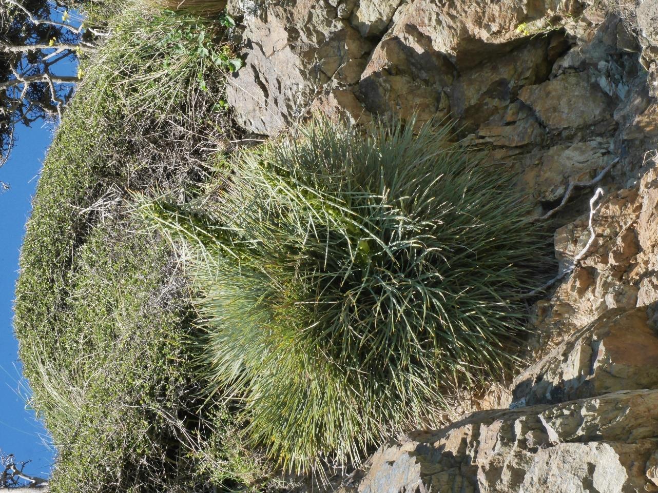
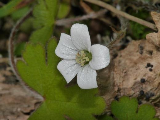
Aciphylla squarrosa var.
squarrosa. Photo 7(2)(a)
WCC SNA Botanical Ground-truthing of the Wellington South Coast 2021/22 - Surveyed by 7(2)(a) – RESTORE
Scope
Wellington City Council (WCC) contracted 7(2)(a)
RESTORE to improve the accuracy and capture of
ecological values within the Wellington’s South Coast - Te Kopahou SNA to support better management of
these sites by WCC officers. In particular to ground truth SNAs and produce a more detailed inventory of
the significant ecological values, identified within the larger sites.
Methodology
The general approach for surveying the area was to start at Sinclair Head at the Western most extent of
the site and work back toward the car park area on the eastern boundary of the site. A transect of sorts was
travelled along recording all species of interest seen as well as recording locations of interest using a GPS
unit. The ‘transect’ is not completely linear as the substrate, vegetation and terrain depicted dictated where
could be surveyed safely and thoroughly. For example, large swathes of gorse were not investigated due
inaccessibility.
The SNA was visited 18 times during this survey from July 2021 to February 2022. Due to weather and
time constraints, a mixture access points and timings was used to complete the survey.
Species were reported according to their Regional Threat Classification (Crisp, 2020), or National Threat
Classification (de Lange
et. al., 2018).
Specific Site Descriptions (Zones)
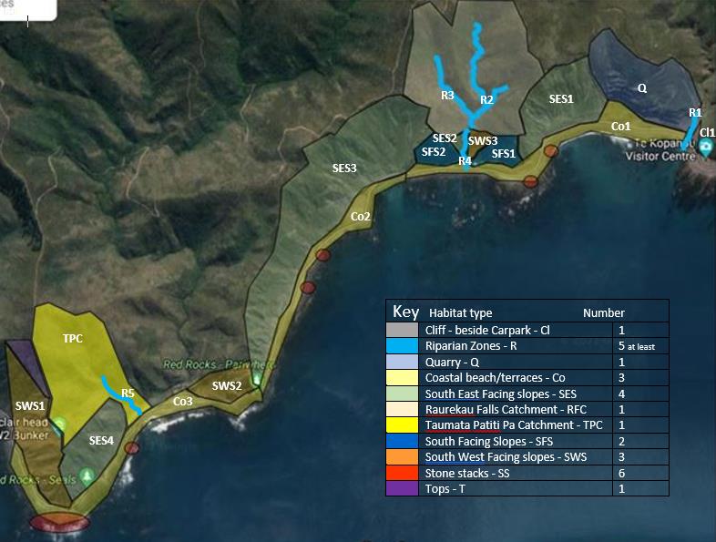
The SNA was split into various zones based on their geomorphology as illustrated in Map 1. Further details
of each zone are highlighted in the following sections. Each species list was recorded as per zone and can
be seen in the accompanying spreadsheet ‘Te Kopahou South Coast Survey Species Data’.
Map 1. The SNA zones surveyed during this project.
2
WCC SNA Botanical Ground-truthing of the Wellington South Coast 2021/22 - Surveyed by 7(2)(a) RESTORE
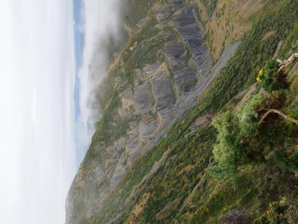
CLIFF
This only includes the area directly west of the Te Kopahou carpark as it is relatively unique in its steepness
and location. This is a very small zone which did not take much evaluation.
COAST
This includes habitat at the base of the slopes which may been dune, unworked scree, and beach. A couple
of seeps are also present. Scree fans were also included in the ‘coast’ zones due to the general gradual
slope and composition of substrate being weathered greywacke.
STONE STACKS
Any rock stacks seaside of the access road, including any sea surrounded rocks as long as vegetation is
present and able to be identified.
QUARRY
This encompasses the area formally used as a quarry. This area is artificially modified to include steeper
than usual bedrock faces, as well as flat(ish) platforms. This type of habitat is unique in the survey area.
RIPARIAN
These sites are the area directly near and affected by a stream. The likelihood of substrate which may be
affected either positively or negatively by constant water supply. Areas like this can also have a higher
humidity than sites nearby which may allow species to thrive that would not otherwise.
CATCHMENTS
Two catchments (Raurekau Falls and Taumata Patiti Pa) were added to the survey after initial feedback
was given. Both areas have riparian zones at their floors which lead to the sea on the South Coast. Each
catchment is quite unique as their output is very seasonal and remarkably contained compared to the
greater area.
SLOPES
The majority of the site is regarded as slope, yet some differentiation can be made. The slopes have been
divided into three types dependant on orientation; South-West, South, and South-East. The slopes are
steep and are generally composed of rocky outcrops surrounded by either stable or unstable scree.
Pest Animal Sign
14/7/21 – During survey of Sinclair Head a lot of pig routing and scat was noted. Saw a live possum in
SWS1 toward the top edge intersection which ran as soon as it saw me. Some of the lower slope
Aciphylla
squarrosa ssp. squarrosa showed signs of being nibbled by deer/hare/rabbit.
Most of the
Pimelea sp. appeared to be targeted by rabbit/Hare, leaving a small remnant of the plant alive
but in poor health.
23/7/21 - Possum seen on true left of lower section (R4) bank of Raurekau Catchment.
11/8/21 – Live possum seen on Eastern edge of Raurekau Falls Catchment, at top of lower branch to
tributary R2. Two rats ran across my note board as I pushed through some vegetation at the bottom of the
true left tributary of Raurekau Falls catchment.
24/9/21 – Live possum seen sleeping in the rotting remnant of a
Phormium sp.
29/9/21 – Live possum ambled off in front of me at top of eastern edge of SES3.
15/10/21 – Live Hare seen in terraced area above Red Rocks (SWS2). Live possum seen living/sleeping
under
Coprosma propinqua in Northern section of the Taumata Patiti Pa catchment
9/2/22 – SES1/SWS3/SFS - Three live possums seen during this day’s survey. All seemed pretty relaxed
with my presence to the point I managed to take photos. There was lots of rabbit scat present in the SES1
area.
In the zone SWS3 in the upper reaches particularly there was a lot of pig scat, so much so it felt as if the
area was where they might reside. There were a couple of flattened out areas of vegetation.
3
WCC SNA Botanical Ground-truthing of the Wellington South Coast 2021/22 - Surveyed by 7(2)(a) – RESTORE
Native Species of Interest
Table 1. shows how many data points of the species were collected throughout the entire site. Further details per zone are included later in the report including a zone-
specific threat rating compared to a general rating shown in Table 2. Some of the species featured below are not locally or nationally threatened, but may be of interest to
WCC for seed sources etc. Some of the species featured in the accompanying document ‘WCC South Coast SNA Survey 2021/22’ may not have been recorded on GPS
and are therefore not in Table 1.
Table 1. Targeted native species of interest.
GPS
# Of
# Of zones
Species
Threat Classification
Threats
Points specimens represented
Aciphylla squarrosa var. squarrosa
Vulnerable
137
516
9
Medium – Predation (Pigs depending on locale)
Anthosachne solandri
Endangered
14
38
3
Low – Erosion/ browsing
Brachyglottis lagopus
Naturally Uncommon
24
585
7
None
Caladenia variegata
Naturally Uncommon
1
4
1
Medium – Plant collectors
Carex cyanea
At Risk - Declining
22
52
5
None
Clematis afoliata
Regionally Naturally Uncommon
1
1
1
Medium – Isolation from other specimens
Corybas macranthus
Not Threatened
1
30
3
Low – Plant collectors
Craspedia uniflora var. maritima
Endangered
74
2532
8
None
Crassula mataikona
Naturally Uncommon
5
10
10
None
Freycinetia banksii
Not Threatened
1
1
1
Low – Browsing (Goat)
Fuchsia colensoi (F. excorticata X F. perscandens)
Unusual Hybrid
2
3
1
Medium - Erosion
Fuchsia perscandens
Locally Uncommon
18
51
3
None, possibly regional stronghold
Leptospermum scoparium var. scoparium
Nationally Vulnerable
60
765
6
Low – Myrtle Rust
Linum monogynum var. monogynum
At Risk - Declining
26
265
9
None
Melicytus crassifolius
Regionally Declining
10
22
6
Low – Browsing (Rabbit, Hare)
Melicytus orarius
Regionally Critical
2
2
1
Low – Track-side maintenance
Metrosideros fulgens
Nationally Vulnerable
1
2
1
Low – Myrtle Rust
Metrosideros perforata
Nationally Vulnerable
9
42
4
Low – Myrtle Rust
Pimelea prostrata ssp. seismica
Data Deficient
33
189
7
Low – Erosion (Not Immediate)
Poa billiardierei
Declining
1
40
1
Low - Browsing
Pterostylis foliata
Naturally Uncommon
1
55
3
Medium – Plant collectors
Raoulia hookeri ssp. hookeri
Declining
42
2277
6
Low - Erosion
Rubus squarrosus
Not Threatened
2
2
3
None
Scandia geniculata
Naturally Uncommon
87
295
5
None
Senecio aff. rufiglandulosus
Data Deficient
3
7
2
None
Sophora molloyi
Regionally Critical
24
64
5
Low - Erosion
Trisetum antarcticum
Declining
4
14
2
None
Vittadina australis
Endangered
15
92
4
Low – Adventive Overgrown
4
WCC SNA Botanical Ground-truthing of the Wellington South Coast 2021/22 - Surveyed by7(2)(a) RESTORE
Native Species – General split of species
Table 2. General split of native species present in the zones defined in Map 1.
South
South East Raurekau
Taumata
South
West
Stone
ZONE
Cliff
Riparian
Quarry
Coast
Facing
Falls
Patiti Pa
Facing
Tops
Facing
Stacks
Slope
Catchment Catchment
Slopes
Slopes
Number of Species recorded
20
155
93
77
119
146
91
49
96
34
38
Structural Class
#
%
#
%
#
%
#
%
#
%
#
%
#
%
#
%
#
%
#
%
#
%
MONOCOT TREES & SHRUBS
1
0.6
1
0.7
DICOT TREES & SHRUBS
7
35.0
37
23.9
21
23.0
21
27.3
25
21.0
33
22.8
19
20.9
12
24.5
23
24.0
6
17.6
11
29.0
MONOCOT LIANES
1
0.6
1
0.7
DICOT LIANES & TRAILING PLANTS
2
10.0
8
5.2
6
6.2
8
10.4
9
7.6
14
7.9
8
8.7
2
4.1
6
6.2
3
8.8
3
7.9
CLUBMOSSES & QUILLWORTS
1
0.7
FERNS & FORK FERNS
1
5.0
34
21.9
21
23.1
9
11.6
15
12.6
30
20.7
22
24.3
10
20.4
14
14.6
2
5.8
12
31.6
ORCHIDS
2
10.0
5
3.2
2
2.2
2
2.6
6
5.0
8
5.7
5
5.4
4
8.2
4
4.2
1
3.0
GRASSES
1
5.0
8
5.2
6
6.2
5
6.5
9
7.6
4
2.9
4
4.3
4
8.2
8
8.4
3
8.8
1
2.6
SEDGES
12
7.7
3
3.1
5
6.5
5
4.2
8
5.7
3
3.3
1
2.0
5
5.2
1
3.0
1
2.6
RUSHES & ALLIED PLANTS
1
5.0
4
2.6
3
3.1
4
5.2
2
1.7
4
2.9
3
3.3
2
4.1
2
2.1
1
3.0
1
2.6
HERBS - MONOCOT, OTHER THAN
1
5.0
4
2.6
2
2.1
2
2.6
4
3.4
4
2.9
3
3.3
1
2.0
2
2.1
1
3.0
2
5.2
ORCHIDS, GRASSES etc.
HERBS - DICOT COMPOSITES
8
5.2
9
9.6
4
5.2
13
10.9
12
8.4
7
7.7
7
14.3
11
11.4
3
8.8
1
2.6
HERBS - DICOT OTHER THAN
5
25.0
33
21.3
20
21.4
17
22.1
31
26.0
26
18.0
17
18.8
6
12.2
21
21.8
13
38.2
6
15.9
COMPOSITES
Key. # = number of species in that group; % = Percentage of total species recorded in that zone
5

WCC SNA Botanical Ground-truthing of the Wellington South Coast 2021/22 - Surveyed by 7(2)(a) RESTORE
Cliff Zone– 1 Area
Surveyed - 12/7/21
Figure 1 shows this area is unique as it faces
North-west (See Map 1.), it is also very close to
the Te Kopahou Visitor Centre carpark and
therefore easily accessible by humans and their
animals. The slope is particularly steep and
generally solid rock.
Threats
•
Human and animal traffic
•
Plant collection
•
North-westerly wind/rain/storms
•
Potential slippage
•
Erosion by Hape Stream
Species
Exact locations of the species in the following
tables can be found in the accompanying
document ‘WCC South Coast SNA Survey
2021/22 - GPS Locations of Species of interest’.
NATIVE
A total of 20 native plant species are present in
the areas within this zone description. One of
Figure 1. The Cliff Zone, the area next to the Te Kopahou
these was unfortunately a pest plant
Pittosporum
Visitor Centre Carpark. 7(2)(a)
crassifolium. Location of all species present in
each of the areas of each zone can be seen in the accompanying spreadsheet document entire survey species
list ‘WCC South Coast SNA Survey 2021/22’. Table 3 shows the recorded GPS points for native species of
interest.
Table 3. Targeted Native Species of Interest in the Cliff Zone.
GPS
Number of
Species
Points specimens Threats
Crassula mataikona
0
Several
None
Pimelea prostrata ssp. seismica
1
2
Erosion – Not Immediate
NON-NATIVE PEST PLANTS
Table 4 shows the GPS points of the pest plant species of interest.
Table 4. Targeted Non-native Species of Interest in the Cliff Zone.
GPS
Number of
Species
Threat Level
Points specimens
Chrysanthemoides monilifera subsp. monilifera
Several
Medium – Good idea to control
•
Boneseed was present in the area but only as a couple of specimens
6

WCC SNA Botanical Ground-truthing of the Wellington South Coast 2021/22 - Surveyed by
–
7(2)(a) RESTORE
Riparian Zone – 3 Areas
Surveyed - 12/7/21, 20/7/21, 23/7/21, 15/9/21,
11/12/21.
These three areas all had running water at the
time of survey and were delineated from
surrounds by the eroded environment either side
of the flowing water.
R1 - Hape Stream - This stream is encountered
as soon as you travel into the Te Kopahou
Reserve and was not specified as an area
needing survey as it has been thoroughly
surveyed in the past. The lower section was
surveyed to gather a species list which could be
compared to those from the other two streams
surveyed.
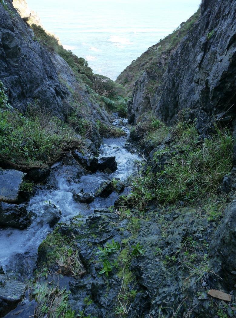
R2, R3, R4 - Un-named Stream to Whare-
Raurekau (Figure 2.) - Running North to South,
a steep un-named waterway utilised by the
baches on the old site of Whare-Raurekau
(Adkins, 1959) nearby as a water supply. The
area has steep cliff-like sides and a series of
waterfalls, which at time of first visit had a
reasonable amount of continuous flow. Several
steps of smaller grade rock material flatten the
span between each side of the waterway. Directly
below the waterfall larger grade rock material is
evident and potentially relatively newly placed.
Figure 2. The un-named stream “Raurekau Falls” above the
R5 - Un-named Stream in Taumata Pa
first area of batches. 7(2)(a)
Catchment - A stream of lower energy and flow
than the other two surveyed therefore showing lower range of species and area surveyed. A track has been
formed beside this stream which makes access to the greater Pa catchment relatively straightforward.
Threats
•
Animal incursions
•
Plant collection
•
Erosion - potential slippage
•
Human activity – water supply to the baches
Species
Exact locations of the species in the following tables can be found in the accompanying document ‘WCC South
Coast SNA Survey 2021/22 - GPS Locations of Species of interest’.
NATIVE
A total of species of 155 native plants are present in the areas within this zone description. Location of all species
present in each of the areas of each zone can be seen in the accompanying spreadsheet document entire
survey species list ‘WCC South Coast SNA Survey 2021/22’. Table 5 shows the recorded GPS points for native
species of interest.
7
WCC SNA Botanical Ground-truthing of the Wellington South Coast 2021/22 - Surveyed by
RESTORE
7(2)(a)
Table 5. Targeted Species of Interest in the Riparian Zone.
GPS
Number of
Species
Threats
Points specimens
Aciphylla squarrosa var. squarrosa
21
95
High - Pig predation
Anthosachne solandri
1
2
Low – Browsing (Rabbit, Hare)
Brachyglottis lagopus
3
24
None
Corybas macranthus
1
30
Low – Plant collection
Craspedia uniflora var. maritima
7
150
None
Crassula mataikona
2
5
None
Freycinetia banksii
1
1
Medium – Browsing (goat)
Fuchsia perscandens X F. excorticata
1
1
Medium - Erosion
Fuchsia perscandens
2
3
None
Leptospermum scoparium
10
40
Low – Myrtle Rust
Linum monogynum var. monogynum
3
43
None
Melicytus crassifolius
5
7
None
Metrosideros fulgens
1
2
Low- Erosion
Metrosideros perforata
4
19
Low - Erosion
Scandia geniculata
16
45
None
Senecio aff. rufiglandulosus
2
4
None
Sophora molloyi
4
5
None
•
Linum monogynum var. monogynum - more common than recorded, too many to record accurately.
•
Freycinetia banksii - only found in the RFC riparian areas.
•
Fuchsia perscandens X F. excorticata - only one specimen seen in the Hape Stream area and in
jeopardy of falling into the stream.
•
Senecio aff. rufiglandulosus - this is a species needing further study as it has unusual features that do
not entirely fit with the species it resembles.
NON-NATIVE PEST PLANTS
Table 6 shows the GPS points of the pest plant species of interest.
Table 6. Targeted Non-native Species of Interest in the Riparian Zone.
GPS
Number of
Species
Threat Level
Points specimens
Berberis darwinii
1
1
Medium – Control while only a few
Buddleja davidii
2
8
Medium – Control while only a few
Chrysanthemoides monilifera subsp. monilifera
14
228
Medium – Good idea to control
Polypodium vulgare
1
1
High – Remove immediately
•
Chrysanthemoides monilifera subsp. monilifera was quite commonly seen sporadically over much of this
site. The specimens noted were generally only in bunches of a few plants except in a couple of
locations.
•
Polypodium vulgare was not seen in this area prior to survey and should be dealt with as soon as
possible (Raurekau Falls Catchment).
•
Berberis darwinii is only in small numbers and could successfully be manually controlled.
•
The area R2 when surveyed had numerous weedy plant species including
Rubus fruticosus, Rubus
lacinatus and English Ivy above.
8

WCC SNA Botanical Ground-truthing of the Wellington South Coast 2021/22 - Surveyed by 7(2)(a) RESTORE
Quarry Zone – 1 Area
Surveyed - 12/7/21, 20/7/21, 29/7/21.
This area was previously a quarry. Figure 3
shows the contours of the cliff face as it remains,
exposed rock faces and drainage ruts provide a
suitable environment for several of the hardier
South Coast flora species.
Threats
• Plant collection
• Potential slippage
Species
Exact locations of the species in the following
tables can be found in the accompanying
document ‘WCC South Coast SNA Survey
2021/22 - GPS Locations of Species of interest’.
NATIVE
A total of 93 native plant species are present in
the areas within this zone description. Location
of all species present in each of the areas of
each zone can be seen in the accompanying
spreadsheet document entire survey species list
‘WCC South Coast SNA Survey 2021/22’. Table
7 shows the recorded GPS points for native
Figure 3. The Quarry Zone – Steep faces are a feature of this
environment.
species of interest.
7(2)(a)
Table 7. Targeted Species of Interest in the Quarry Zone
GPS
Number of
Species
Threats
Points specimens
Aciphylla squarrosa var. squarrosa
10
26
Low - Pig predation
Anthosachne solandri
1
3
Low – Browsing (Rabbit, Hare)
Brachyglottis lagopus
1
20
None
Carmichaelia australis
1
4
None
Craspedia uniflora var. maritima
7
400+
None
Lagenophora pumila
1
5
None
Leptospermum scoparium
5
15
Low – Myrtle Rust
Libertia ixioides
2
35
None
Linum monogynum var. monogynum
2
2
None
Melicytus crassifolius
1
1
None
Melicytus orarius
1
1
Low – Track-side maintenance
Raoulia hookeri var. hookeri
5
800+
Low - Erosion
Scandia geniculata
1
3
None
•
Craspedia uniflora var. maritima – the population found on the faces at the Western end are the
largest in the reserve seen during the survey.
•
Linum monogynum var. monogynum - more common than recorded, too many to record accurately.
•
Raoulia hookeri var. hookeri - the population found on the faces at the Western end are the largest in
the reserve seen during the survey.
9

WCC SNA Botanical Ground-truthing of the Wellington South Coast 2021/22 - Surveyed by 7(2)(a)
RESTORE
NON-NATIVE PEST PLANTS
Table 8 shows the GPS points of the pest plant species of interest.
Table 8. Targeted Non-native Species of Interest in the Quarry Zone.
GPS Number of
Species
Threat Level
Points specimens
Buddleja davidii
2
8
Medium – Control while only a few
Chrysanthemoides monilifera subsp. monilifera
14
228
Medium – Good idea to control
Cortaderia selloana
1
1
High – Remove immediately
Polypodium vulgare
2
11
High – Remove immediately
•
Chrysanthemoides monilifera subsp. monilifera was present in the area but only as a couple of specimens.
•
Polypodium vulgare was not seen in this area prior to survey and should be dealt with as soon as
possible.
•
Cortaderia selloana would be best to be removed before it becomes prolific.
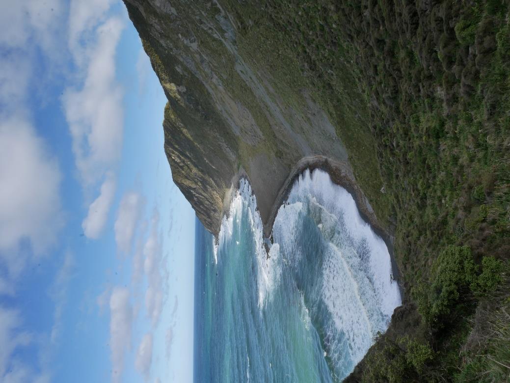
Coast Zone – 3 Areas
Surveyed - 20/7/21, 4/8/21, 15/9/21, 18/11/21.
This area has been divided into three sites in the
survey area, (Map 1).
Co1 - Encompasses the area from the carpark
to just beyond the first baches. This area
includes some restoration plantings which make
it somewhat different from Co2 & Co3.
Co2 - Is the zone from just past the first batches
to Pariwhero – Red Rocks and is South-East
facing. It also includes the lower section of a
stable scree fan
Co3 - Includes the zone from Pariwhero – Red
Rocks to the end of the survey site at Sinclair
Head, including the Seal haul out area.
This zone is the most accessible and dynamic.
Tides and human interaction continually shape
and reshape this zone.
• During the visit on 18/11/21 numerous
lizards (skinks) were seen darting away
as I recorded the plants.
• When recording Co3 the planted areas
near the batches were ignored, lots of
Figure 4. Coastal dwellers -
Pimelea prostrata subsp. seismica
Pohutukawa present in this area.
in flower, with
Raoulia hookeri var. hookeri in the background.
7(2)(a)
10
WCC SNA Botanical Ground-truthing of the Wellington South Coast 2021/22 - Surveyed by 7(2)(a) RESTORE
Threats
• Animal incursions
• Plant collection
• Erosion - potential slippage
• Storm surges
• Human activity – walkers, explorers, and vehicles
Species
Exact locations of the species in the following tables can be found in the accompanying document ‘WCC South
Coast SNA Survey 2021/22 - GPS Locations of Species of interest’.
NATIVE
A total of 77 native plant species are present in the areas within this zone description. Location of all species
present in each of the areas of each zone can be seen in the accompanying spreadsheet document entire
survey species list ‘WCC South Coast SNA Survey 2021/22’. Table 9 shows the recorded GPS points for native
species of interest.
Table 9. Targeted Species of Interest in the Coast Zone.
GPS
Number of
Species
Threats
Points specimens
Aciphylla squarrosa var. squarrosa
3
18
Medium – Tidal/human activity
Leptospermum scoparium
1
1
Low – Myrtle Rust
Linum monogynum var. monogynum
1
20
None
Melicytus crassifolius
1
1
Medium – Tidal/human activity
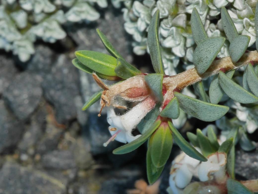
Pimelea prostrata subsp. seismica
10
62
Medium – Tidal/human activity
Plagianthus divaricatus
1
5
Medium – Tidal/human activity
Raoulia hookeri var. hookeri
4
585
Low - Erosion
Sophora molloyi
1
3
Low - Erosion
•
Linum monogynum var. monogynum - more common than recorded, too many to record accurately.
•
Plagianthus divaricatus - this species only noted once on the whole survey, near the Seal haul out
area.
•
Pimelea prostrata subsp. seismica (Figure 4.) – the largest population with the healthiest plants seen
in this zone.
NON-NATIVE PEST PLANTS
Table 10 shows the GPS points of the pest plant species of interest.
Table 10. Targeted Non-native Species of Interest in the Riparian Zone.
GPS
Number of
Species
Threat Level
Points specimens
Chrysanthemoides monilifera subsp. monilifera
1
8
Medium – Good idea to control
Clematis vitalba
1
5
High – Remove immediately
Glaucium flavum
2
6
Medium – Remove while only a few
•
Chrysanthemoides monilifera subsp. monilifera not seen in volumes, quite achievable to control.
•
Clematis vitalba – ideally remove before it spreads.
11

WCC SNA Botanical Ground-truthing of the Wellington South Coast 2021/22 - Surveyed by 7(2)(a)
RESTORE
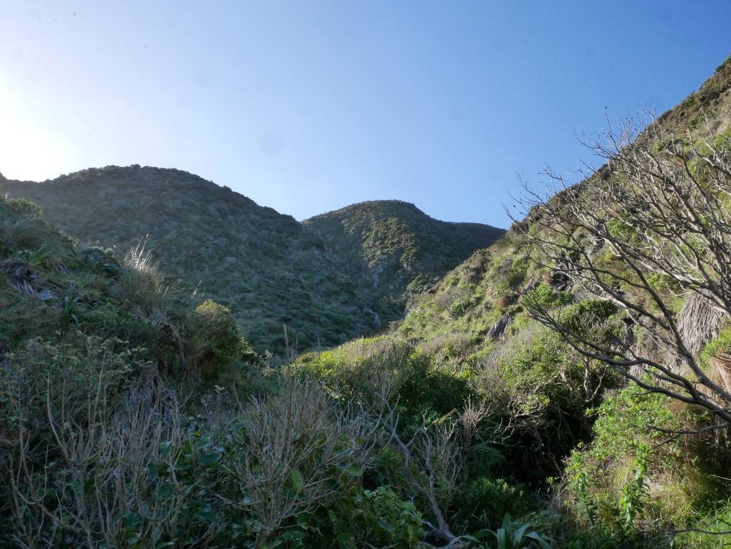
South-East Slope Zone – 4 Areas
Surveyed - 29/7/21, 4/8/21, 11/8/21, 15/9/21,
29/9/21, 29/10/21, 10/11/21, 18/11/21, 24/11/21,
9/2/22.
In total these 4 areas make up the largest part of
the survey (Map 1).
SES1 – This area is from the Quarry to east of
the first baches below Raurekau Falls.
SES2 – This is the smallest of the 4 areas and
was particularly difficult to survey. It is the slope
above the R4 section of the lower part of the
Raurekau Falls.
SES3 (Figure 5.) – This is the largest single
section of the survey. The area starts at the
western edge of the Raurekau Falls Catchment
and extends to the point formed by Red Rocks.
SES4 – This area is on the eastern slope of
Sinclair head and is bordered by the Taumata
Patiti Pa Catchment.
• A native NZ Falcon was seen speeding
past early in the day of 9/2/22.
• The area above and South of the
Raurekau Falls Catchment at the
extreme West of SES1 was mostly
Figure 5. SES3 – The largest area of any Zone in the survey.
Gorse and unable to be surveyed.
7(2)(a)
Threats
• Animal incursions
• Plant collection
• Erosion - Potential slippage
Species
Exact locations of the species in the following tables can be found in the accompanying document ‘WCC South
Coast SNA Survey 2021/22 - GPS Locations of Species of interest’.
NATIVE
A total of 119 native plant species are present in the areas within this zone description. Location of all species
present in each of the areas of each zone can be seen in the accompanying spreadsheet document entire
survey species list ‘WCC South Coast SNA Survey 2021/22’. Table 11 shows the recorded GPS points for native
species of interest.
12
WCC SNA Botanical Ground-truthing of the Wellington South Coast 2021/22 - Surveyed by
–
7(2)(a) RESTORE
Table 11. Targeted Species of Interest in the South-East Slope Zone.
GPS
Number of
Species
Threats
Points specimens
Aciphylla squarrosa var. squarrosa
56
199
Low – Browsing by rabbit/hare
Anthosachne solandri
10
20
None
Brachyglottis lagopus
4
250
None
Carex breviculmis
1
1
None
Carex cyanea
3
5
None
Clematis afoliata
1
1
None
Craspedia uniflora var. maritima
29
792
None
Crassula mataikona
1
1
None
Leptospermum scoparium
25
445
Low – Myrtle Rust
Linum monogynum var. monogynum
8
127
None
Melicytus crassifolius
1
1
Low - Slips
Metrosideros perforata
1
10
Low – Myrtle Rust
Pimelea prostrata subsp. seismica
13
94
Medium – Browsing by rabbit/hare
Pterostylis foliata
2
22
None
Raoulia hookeri var. hookeri
16
184
Low - Erosion
Scandia geniculata
10
26
None
Sophora molloyi
7
7
Low - Erosion
Trisetum antarcticum
1
4
None
Vittadina australis
9
71
Low - Overgrown
•
Aciphylla squarrosa var. squarrosa – Good amount in this zone, potentially as refugia due to
inaccessibility of sites.
•
Brachyglottis lagopus & Craspedia uniflora var. maritima – commonly seen in good numbers in areas
of outcrop which also have slight seeps.
•
Linum monogynum var. monogynum - more common than recorded, too many to record accurately.
•
Pimelea prostrata subsp. seismica – overall a good amount found, but many were small plants which
had been trimmed by browsing.
•
Pterostylis foliata – Not seen in this area prior to survey, due to accessibility.
NON-NATIVE PEST PLANTS
Table 12 shows the GPS points of the pest plant species of interest.
Table 12. Targeted Non-native Species of Interest in the South-East Slope Zone.
GPS
Number of
Species
Points specimens Threat Level
Medium – Spreads - controllable while in
Agapanthus praecox subsp. orientalis
1
2
small numbers
Berberis darwinii
Medium – Spreads - controllable while in
2
1
small numbers
Chrysanthemoides monilifera subsp. monilifera
71
423
Medium – Good idea to control
Medium – Spreads - controllable while in
Lupinus arboreus
3
12
small numbers
Medium – Spreads - controllable while in
Pittosporum crassifolium
1
1
small numbers
Medium – Spreads - controllable while in
Senecio angulatus
1
40
small numbers
Ulex europaeus
8
62
Low – Potentially controllable
•
Chrysanthemoides monilifera subsp. monilifera seen in volumes, difficult to control without much expense.
•
Lupinus arboreus is only in small numbers and could successfully be manually controlled.
•
Senecio angulatus is only in small numbers and could successfully be manually controlled.
•
Pittosporum crassifolium is single specimen which could successfully be manually controlled.
•
Ulex europaeus patches away from large swathes could successfully be manually controlled.
13

WCC SNA Botanical Ground-truthing of the Wellington South Coast 2021/22 - Surveyed by 7(2)(a)
RESTORE
Raurekau Falls Catchment
Surveyed - 23/7/21, 31/7/21,
11/8/21, 24/9/21, 29/9/21,
24/11/21, 9/2/22.
This area was a late addition
to the survey area due to its
uniqueness in being a small
catchment
feeding
the
Raurekau Falls. This water
is the supply used by the first
group
of
baches
encountered on the coastal
trail. Figure 6 (next page)
shows the area contains two
tributaries detailed on Map
1, as R2 and R3.
The
eastern
west-facing
slope has dense vegetation
of
mahoe,
gorse,
and
Coprosma propinqua, and is
quite slow to manoeuvre
through.
The
southern
Figure 5. The Raurekau Falls Catchment - Looking north up towards the steep
section of the western side
terrain and catchment area.7(2)(a)
of the catchment has a large
area of impenetrable gorse which needed to be detoured below then back up to survey the vegetation on the
other side of it.
The tributaries are well vegetated towards their upper reaches, the lower section is sparsely vegetated before
dropping off into the fall’s valley.
• Numerous skinks were seen on the upper exposed stony slopes of the East-facing Western section
(24/11/21).
Threats
• Pig-sign is relatively common in parts of this catchment, either below the canopy on the east, or in the
open areas of lower section towards the Falls. In the east the understory was lacking due mainly to the
consistent routing. The west section also has large swathes of excavated substrate below the
shrubbery.
• Possums (live) were seen several times during this survey.
• Rats were encountered on one occasion possibly suggesting high numbers.
Species
Exact locations of the species in the following tables can be found in the accompanying document ‘WCC South
Coast SNA Survey 2021/22 - GPS Locations of Species of interest’.
NATIVE
A total of 146 native plant species are present in the catchment areas within this zone description, this does not
include the riparian zone (which are featured in the Riparian Zone of this report). When the 3 riparian areas
within this zone are included a further 31 species can be considered, . Location of all species present in each of
the areas of each zone can be seen in the accompanying spreadsheet document entire survey species list ‘WCC
South Coast SNA Survey 2021/22’. Table 13 shows the recorded GPS points for native species of interest.
14
WCC SNA Botanical Ground-truthing of the Wellington South Coast 2021/22 - Surveyed by
–
7(2)(a) RESTORE
Table 13. Targeted Species of Interest in the Raurekau Falls Catchment Zone.
GPS
Number of
Species
Threats
Points specimens
Aciphylla squarrosa var. squarrosa
2
5
High – Pig predation
Astelia fragrans
1
1
None
Brachyglottis lagopus
7
126
None
Caladenia variegata
1
4
None
Carex cyanea
18
38
None
Carmichaelia australis
1
25
None
Corybas macranthus, Pterostylis graminea,
1
100+
None
P. banksii
Craspedia uniflora var. maritima
6
170+
None
Fuchsia perscandens
18
51
None
Geranium microphyllum aff.
1
2
None
Leptospermum scoparium
4
7
Low – Myrtle Rust
Libertia ixioides
1
1
None
Linum monogynum var. monogynum
5
24
None
Melicytus orarius
1
1
None
Pimelea prostrata subsp. seismica
1
1
Medium – Browsing by rabbit/hare
Pterostylis foliata
1
15
None
Raoulia hookeri var. hookeri
1
2
None
Rubus cissoides
1
1
None
Rubus squarrosus X R. cissoides
1
1
None
Rubus squarrosus
2
2
None
Scandia geniculata
59
220
None
Senecio rufiglandulosus aff.
1
3
None
Sophora molloyi
9
28
Low - Erosion
Trisetum antarcticum
1
4
None
Vittadina australis
1
4
Low - Overgrown
• This catchment is an area with highly concentrated populations of
Fuchsia perscandens and
Scandia
geniculata.
NON-NATIVE PEST PLANTS
Table 14 shows the GPS points of the pest plant species of interest.
Table 14. Targeted Non-native Species of Interest in the Raurekau Falls Catchment Zone.
GPS
Number of
Species
Threat Level
Points specimens
Medium – Spreads - controllable while
Berberis darwinii
26
56
in relatively small numbers
Chrysanthemoides monilifera subsp. monilifera
12
89
Medium – Good idea to control
Ilex aquifolium
1
1
Medium – Spreads via fruit
Lonicera japonica
1
3
High – Good to remove
Lupinus arboreus
1
6
Medium – Spreads
•
Polypodium vulgare was in this catchment (see Riparian Zone of this report).
• Several
Berberis darwinii specimens were noted and recorded in the area which due to the small number
would be quite possibly controllable with not too much effort.
•
Chrysanthemoides monilifera subsp. monilifera seen in volumes, difficult to control without much expense.
•
Ilex aquifolium – ideally remove before it spreads.
•
Lupinus arboreus is only in small numbers and could successfully be manually controlled.
•
Lonicera japonica would be ideal to remove, but these specimens are well established in relatively
mature native vegetation.
• Gorse patches too big to mention or try and control.
15

WCC SNA Botanical Ground-truthing of the Wellington South Coast 2021/22 - Surveyed by
–
7(2)(a) RESTORE
Taumata Patiti Pa Catchment
Surveyed – 15/10/21, 21/10/21
This area was a late addition to the survey area
due to its uniqueness in being a small
catchment feeding the historic Taumata Patiti
Pa site west of Waipapa Stream. This water is
the supply used by the last bach encountered
on the coastal trail. The area contains two
tributaries detailed on the map as R5.
A rudimentary track has been formed which is
why I was asked to survey this area as it
provides an entrance point for human
introduced weed species. The eastern west-
facing slope has dense vegetation of gorse and
Coprosma propinqua and is quite slow to
manoeuvre through unless a clear path is
chosen. The tributaries are mostly dry until
towards the steeper walled valley begins below
their confluence.
Threats
• The area appears to have very few
Berberis darwinii, which could be
successfully controlled.
• Gorse in present but mostly in patches
which may be a consideration for
control.
• A single patch of
Polypodium vulgare
Figure 6. Residents of the Taumata Patiti Pa Catchment –
was found in the catchment.
Clockwise
Fuchsia perscandens, Geranium aff. microphyllum,
•
Corybas macranthus, Crassula sieberiana. 7(2)(a)
Evidence of Pigs using the area was
seen.
Species
Exact locations of the species in the following tables can be found in the accompanying document ‘WCC South
Coast SNA Survey 2021/22 - GPS Locations of Species of interest’.
NATIVE
A total of 99 native plant species are present in the catchment areas within this zone description, this does not
include the riparian zone (which are included in the Riparian Zone section). When the riparian area within this
zone is included a further 9 species can be considered. Table 15 shows the recorded GPS points for native
species of interest.
All species present in the area of this zone can be seen in the accompanying spreadsheet document entire
survey species list ‘WCC South Coast SNA Survey 2021/22’.
16
WCC SNA Botanical Ground-truthing of the Wellington South Coast 2021/22 - Surveyed by
RESTORE
7(2)(a)
Table 15. Targeted Species of Interest in the Taumata Patiti Pa Catchment Zone.
GPS
Number of
Species
Threats
Points specimens
Brachyglottis lagopus
1
2
None
Craspedia uniflora var. maritima
2
23
None
Fuchsia perscandens
14
56
None
Geranium aff. microphyllum.
1
1
None
Libertia ixioides
1
3
None
Linum monogynum var. monogynum
5
24
None
Melicytus crassifolius
3
3
Medium – Browsing by rabbit/hare
Pimelea prostrata subsp. seismica
1
1
Medium – Browsing by rabbit/hare
Pterostylis foliata
1
1
None
Rubus squarrosus
2
6
None
Scandia geniculata
23
98
None
Vittadina australis
3
18
Low - Overgrown
•
This catchment is also another area with concentrated populations of
Fuchsia perscandens and
Scandia geniculata.
NON-NATIVE PEST PLANTS
Table 16 shows the number of GPS points of the pest plant species of interest.
Table 16. Targeted Non-native Species of Interest in the Taumata Patiti Pa Catchment Zone.
Number of
Species
GPS
Threat Level
Points specimens
Medium – Spreads - controllable while in
Berberis darwinii
1
1
small numbers
Chrysanthemoides monilifera subsp. monilifera
17
40
Medium – Good idea to control
Medium – Spreads - controllable while in
Pittosporum crassifolium
2
2
small numbers
Polypodium vulgare
1
5
High – Remove immediately
Medium – Spreads - controllable while in
Rosa rubiginosa
1
1
small numbers
Ulex europaeus
4
28
Low – Patches could be controlled
•
Berberis darwinii is only in small numbers and could successfully be manually controlled.
•
Chrysanthemoides monilifera subsp. monilifera seen in low volumes compared to other areas, may be
worth controlling in this Zone.
•
Pittosporum crassifolium – ideally remove before it spreads.
•
Polypodium vulgare was not seen in this area prior to survey and should be dealt with as soon as
possible.
•
Ulex europaeus patches not too big to possibly eradicate from the area.
17

WCC SNA Botanical Ground-truthing of the Wellington South Coast 2021/22 - Surveyed by 7(2)(a) RESTORE
South Facing Slopes Zone – 2 Areas
Surveyed – 15/9/21, 24/11/21, 9/2/22.
This zone comprises of two faces either side of
the Raurekau Falls riparian intersection with the
coastline. Both slopes are particularly steep as
can be seen in Figure 7.
Both areas were surveyed mostly from below or
above as the slope terrain was not safe to
traverse.
Threats
•
Coastal erosion is the only likely issue
for these 2 areas, yet both areas are
some height above the high tide mark
for now.
•
Human interaction may prove a
problem in time as they are above
baches.
•
Gorse is present in large volumes and
not safely controllable.
•
A live possum was recorded at the top
of SFS1 in the area transitioning into a
more gradual slope.
Species
Exact locations of the species in the following
Figure 7. Looking across SFS2 from the south side (top of
SWS3). 7(2)(a)
tables can be found in the accompanying
document ‘WCC South Coast SNA Survey 2021
- GPS Locations of Species of interest’.
NATIVE
A total of 49 native plant species are present within this zone description. Table 17 shows the recorded GPS
points for native species of interest.
All species present in the areas of this zone can be seen in the accompanying spreadsheet document entire
survey species list ‘WCC South Coast SNA Survey 2021/22’.
Table 17. Targeted Species of Interest in the South Facing Slope Zone.
GPS
Number of
Species
Threats
Points specimens
Aciphylla squarrosa var. squarrosa
4
5
None
Brachyglottis lagopus
5
165
None
Craspedia uniflora var. maritima
5
190
None
Leptospermum scoparium
8
58
None
Libertia ixioides
1
1
None
Linum monogynum var. monogynum
5
24
None
Pterostylis foliata
1
18
None
Raoulia hookeri var. hookeri
6
84
None
Scandia geniculata
1
1
None
18

WCC SNA Botanical Ground-truthing of the Wellington South Coast 2021/22 - Surveyed by7(2)(a) RESTORE
NON-NATIVE PEST PLANTS
Table 18 shows the GPS points of the pest plant species of interest.
Table 18. Targeted Non-native Species of Interest in the South Facing Slope Zone.
GPS
Number of
Species
Threat Level
Points specimens
Chrysanthemoides monilifera subsp. monilifera
3
14
Medium – Good idea to control
Lupinus arboreus
1
165
Medium – Spreads
•
Chrysanthemoides monilifera subsp. monilifera seen in low volumes compared to other areas, may be
worth controlling in this Zone.
•
Lupinus arboreus would be difficult to remove/control easily without some sort of aerial application.
South-West Slope Zone – 3 Areas
Surveyed - 14/7/21, 15/10/21, 18/11/21, 9/2/22.
Differentiated from the majority of the slope
habitat by the fact these slopes face south-west
which ensures they receive more sunshine hours
than others, especially whilst the sun curvature is
lower during the winter months. (may be
interesting to see what differences there are with
species composition).
SWS1 – This area is represented by the western
most extent of the SNA survey, this is the sunny
side of Sinclair Head (Figure 8.).
SWS2 – The sunny slope above Red Rocks from
the ridgeline to Waipapa Stream’s eroded east-
side.
SWS3 – The small sunny patch above the
Raurekau Falls Riparian area R4.
Threats
•
Erosion, fresh tongues of slippage
evident in places, particularly SWS1.
•
Massive amounts of
Centranthus ruber – Red Valerian particularly in SWS2.
•
Southern section of SWS1 has had a lot
of pig routing of the
Aciphylla squarossa
Figure 8. Sun hitting the slope SWS1 of Sinclair head in July.
var. squarossa, almost down to sea
Photo 7(2)(a)
level.
•
SWS3 had a lot of boneseed and gorse present directly above the batches on the southern extent of
area.
Species
Exact locations of the species in the following tables can be found in the accompanying document ‘WCC South
Coast SNA Survey 2021/22 - GPS Locations of Species of interest’.
19
WCC SNA Botanical Ground-truthing of the Wellington South Coast 2021/22 - Surveyed by 7(2)(a)
RESTORE
NATIVE
A total of 96 native plant species are present in the areas within this zone description. Location of all species
present in each of the areas of each zone can be seen in the accompanying spreadsheet document entire
survey species list ‘WCC South Coast SNA Survey 2021’. Table 19 shows the recorded GPS points for native
species of interest.
Table 19. Targeted Species of Interest in the South West Slope Zone.
Number of
Species
GPS
Threats
Points specimens
Aciphylla squarrosa var. squarrosa
38
161
High – Predation by Pig
Anthosachne solandri
2
13
None
Brachyglottis lagopus
4
10
None
Craspedia uniflora var. maritima
19
820
None
Crassula mataikona
2
4
None
Leptospermum scoparium
7
200
Low – Myrtle Rust
Linum monogynum var. monogynum
1
15
None
Melicytus crassifolius
2
12
Low - Slips
Metrosideros perforata
4
13
Low – Myrtle Rust
Pimelea prostrata subsp. seismica
9
32
Medium – Browsing by rabbit/hare
Poa billiardierei
1
40
None
Raoulia hookeri var. hookeri
10
620
Low - Erosion
Sophora molloyi
3
21
Low - Erosion
Trisetum antarcticum
2
6
None
Vittadina australis
5
17
Low - Overgrown
•
Aciphylla squarrosa var. squarrosa – Good amount in this zone, potentially as refugia due to
inaccessibility of sites.
•
Craspedia uniflora var. maritima – commonly seen in good numbers in areas of outcrop which also
have slight seeps.
•
Linum monogynum var. monogynum - more common than recorded, too many to record accurately.
•
Poa billiardierei – only location during survey this species was noted (SWS1).
•
Pterostylis foliata – Not seen in this area prior to survey, due to accessibility.
NON-NATIVE PEST PLANTS
Table 20 shows the GPS points of the pest plant species of interest.
Table 20. Targeted Non-native Species of Interest in the South West Slope Zone.
GPS
Number of
Species
Points specimens Threat Level
Berberis darwinii
Medium – Spreads - controllable while in
1
1
small numbers
Chrysanthemoides monilifera subsp. monilifera
26
112
Medium – Good idea to control
Hedera helix
1
10
Medium - Good idea to control
Medium – Spreads - controllable while in
Lupinus arboreus
1
3
small numbers
Ulex europaeus
2
80
Low – Potentially controllable
•
Berberis darwinii is only a small number and could be successfully manually controlled.
•
Chrysanthemoides monilifera subsp. monilifera seen in volumes, difficult to control without an expensive
campaign.
•
Lupinus arboreus is only in small numbers and could successfully be manually controlled.
•
Hedera helix is only in small numbers and could successfully be manually controlled.
•
Ulex europaeus patches away from large swathes could successfully be manually controlled.
20

WCC SNA Botanical Ground-truthing of the Wellington South Coast 2021/22 - Surveyed by7(2)(a)RESTORE
Stone Stacks Zone – 6 Areas
Surveyed - 4/8/21
Only rocky outcrops coastward of the coastal
access road were considered for this zone of the
survey, all species found in this zone are
particularly salt tolerant (see Figure 8.). This zone
represents the most volatile as some sites are
temporary due to coastal process interactions.
There are several rocky outcrops along the coast
with the largest and most diverse being that
beyond Red Rocks which is referred to Devil’s
Gate.
Threats
•
Human interaction
•
Storms
•
Tidal erosion
Species
Exact locations of the species in the following
tables can be found in the accompanying
document ‘WCC South Coast SNA Survey 2021
- GPS Locations of Species of interest’.
NATIVE
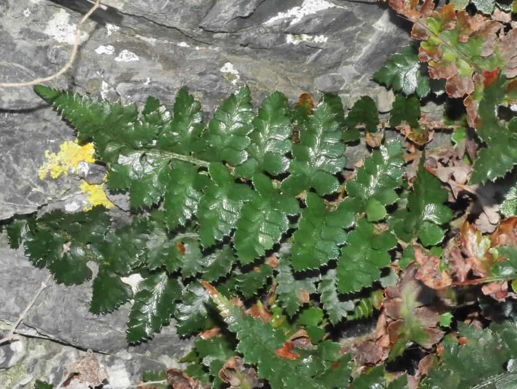
Figure 8. Polystichum oculatum, residing on Devil’s Gate, and
A total of 37 native plant species are present in
looking more robust, and greener than the usual blue-green
this zone description. Location of all species
this species is renowned for. 7(2)(a)
present in each of the areas of each zone can be
seen in the accompanying spreadsheet document entire survey species list ‘WCC South Coast SNA Survey
2021/22’. Table 21 shows the recorded GPS points for native species of interest.
Table 20. Targeted Species of Interest in the Stone Stacks Zone.
GPS
Number of
Species
Threats
Points specimens
Aciphylla squarrosa var. squarrosa
3
7
Low – Plant collection
Craspedia uniflora var. maritima
1
2
None
Linum monogynum var. monogynum
1
10
None
•
Aciphylla squarrosa var. squarrosa – Only seen at Devil’s Gate.
NON-NATIVE PEST PLANTS
There were no GPS points recorded for pest plant species of interest in this zone.
21

WCC SNA Botanical Ground-truthing of the Wellington South Coast 2021/22 - Surveyed by7(2)(a) RESTORE
Tops Zone – 1 Area
Surveyed - 14/7/21
An
unusual
area
being
somewhat unique to the
survey, due to its isolation.
The Tops Zone is one area
Located on the border of the
SNA and private land and is
high above Sinclair Head as
shown in Figure 9. The area
was particularly wet during the
survey suggesting a seep was
likely.
Threats
•
Pigs
•
Storms
Species
Figure 9. Top of the Tops Zone looking down on Sinclair Head. 7(2)(a)
Exact locations of the species
in the following tables can be
found in the accompanying document ‘WCC South Coast SNA Survey 2021/22 - GPS Locations of Species of
interest’.
NATIVE
A total of 41 native plant species are present in this zone description. Location of all species present in each of
the areas of each zone can be seen in the accompanying spreadsheet document entire survey species list ‘WCC
South Coast SNA Survey 2021/22’. Table 21 shows the recorded GPS points for native species of interest.
Table 21. Targeted Species of Interest in the Tops Zone.
GPS
Number of
Species
Points specimens Threats
Carex cyanea
1
9
None
•
Carex cyanea – Locally common below the scrub.
NON-NATIVE PEST PLANTS
There were no GPS points recorded for pest plant species of interest in this zone.
22
7(2)(a)
WCC SNA Botanical Ground-truthing of the Wellington South Coast 2021/22 - Surveyed by
RESTORE
References
Adkin, G. L. (1959)
The Great Harbour of Tara – Traditional Maori Place-names and Sites of Wellington
Harbour and Environs. A Revision by G. Leslie Adkin. Printed and published by Whitcomb and Tombs Ltd.
Christchurch Auckland Wellington Dunedin Hamilton Lower Hutt Timaru Invercargill London Melbourne
Sydney Perth Geelong.
Crisp, P. (2020).
Conservation status of indigenous vascular plant species in the Wellington region. Greater
Wellington Regional Council Publication No. GW/ESCI-G-20/20 Wellington. 43 p.
de Lange, P.J.; Rolfe, J.R.; Barkla, J.W.; Courtney, S.P.; Champion, P.D.; Perrie, L.R.; Beadel, S.M.;
Ford, K.A.; Breitwieser, I.; Schonberger, I.; Hindmarsh-Walls, R.; Heenan, P.B.; Ladley, K. (2018)
Conservation status of New Zealand indigenous vascular plants, 2017. New Zealand Threat Classification
Series 22. Department of Conservation, Wellington. 82 p.
Druce, A.P. (1992)
Indigenous vascular Plants between Owhiro Bay and Sinclair Head, Wellington South
Coast, s.l.to 100ft. (based on observations from 1948-1991). Published on New Zealand Plant Conservation
Network website.
Logan, R., Lee, D., Wassilieff, M. (1998)
List of Indigenous Vascular Plant Species and Preliminary List of
Animal Species identified in the Valleys located above the high waterfall on the Stream leading to Whare-
Raurekau* on Wellington South Coast (Map Grid Reference @ R27, R28 & Pt. Q27 554833). SOUTHERN
ENVIRONMENTAL ASSOCIATION (WELLINGTON) INCORPORATED, C/-15 High Street, Island Bay,
Wellington.
Ward, M.D. (2022)
Wellington City Council South Coast SNA Survey 2021. (based on observations from
2021-2022), 8 pages, RESTORE 2022.
Ward, M.D. (2022)
WCC South Coast SNA Survey 2021 - GPS Locations of Species of interest. Excel
spreadsheet. RESTORE 2022.
23