26/10/2023 - E +12 SITREPS
As at 2.44pm on 26/10/2023 prepared by Crispian
approved by Anusha Guler
Distributed All GEDT/ELT members
to
Key
Anusha Guler and Crispian
Contacts
Previous
E+10 SITREPS 7 24102023 - FINAL.docx
ELT SITREP
Overview
Summary of the current event
• Post election process
Voting
GENERAL UPDATE
Services
Overseas Operations
• No issues to report.
• Processing continues, validation / qualification approximately 85% complete.
• One scrutineer today.
Auckland North Region
• No issues to report.
• The election tracker is progressing well, the focus is on a couple of electorates.
• Still awaiting enrolment to complete SVDs before we start our next process. Enrolment will complete SVDs by
Saturday.
Auckland South Region
• No issues to report.
• Seeking assistance from L&P for processing dual votes for Tāmaki Makaurau (118) and Mangere (274).
Central North Island Region
• No issues to report.
• East Coast is back on track and there is a good team here supporting that work.
Lower North Island Region
• No issues to report.
South Island Region
• No issues to report.
• 75% of electorates will start SVs by tomorrow
• There are high levels of dual votes.
Voting Services:
• Request for a post-election debrief from Remutaka MP’s office – Legal has advised that they will be
undertaking candidate survey and debrief with party secretaries, after the release of the official results.
Advised staff to advise any candidate requesting a debrief to provide feedback through the party secretaries.
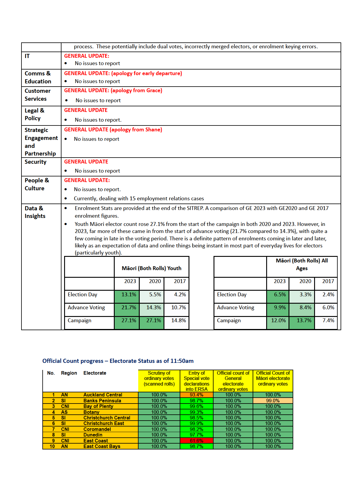
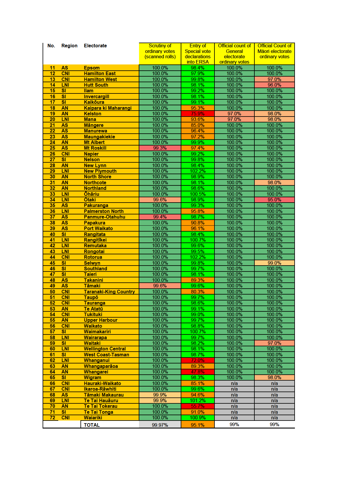
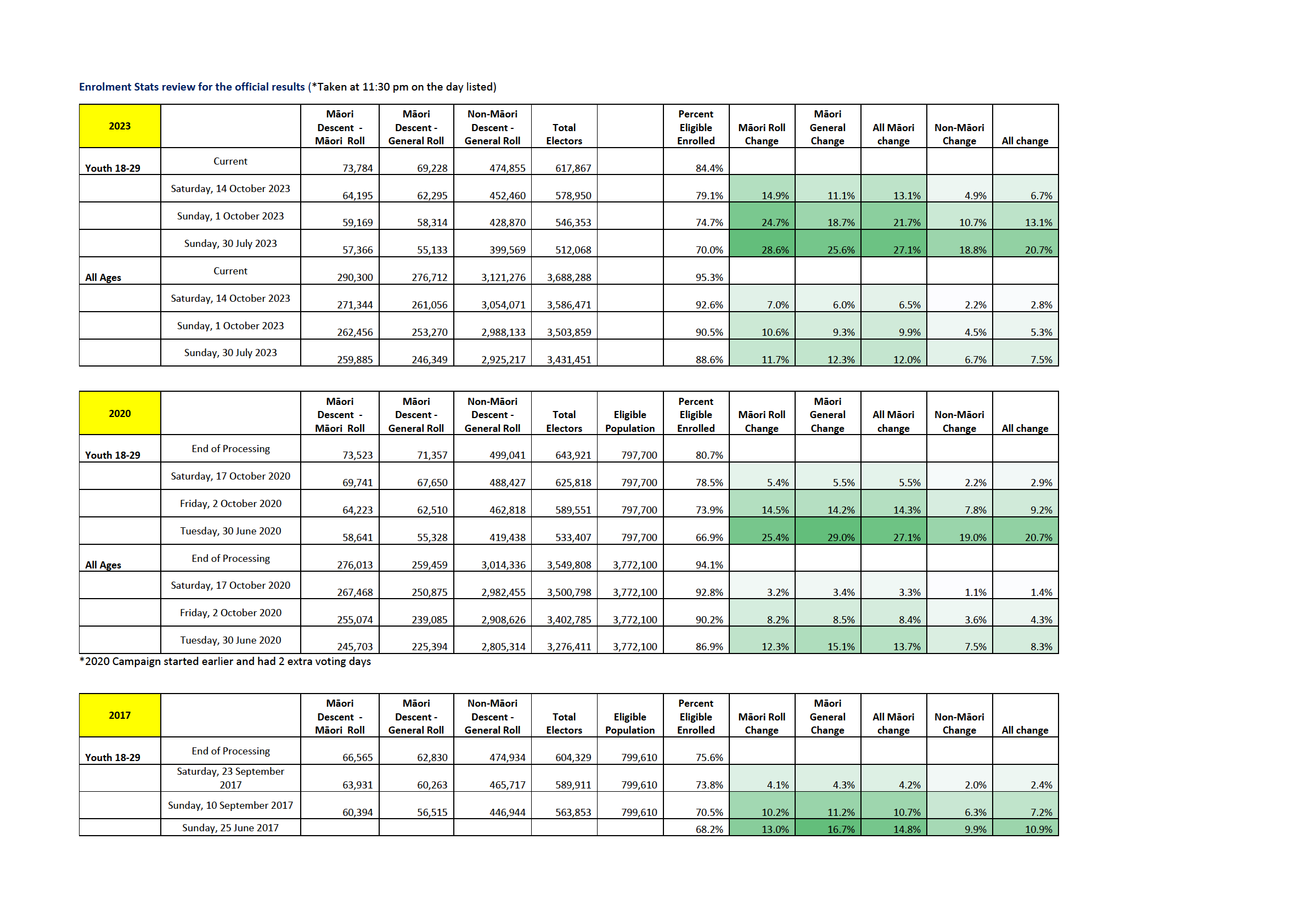
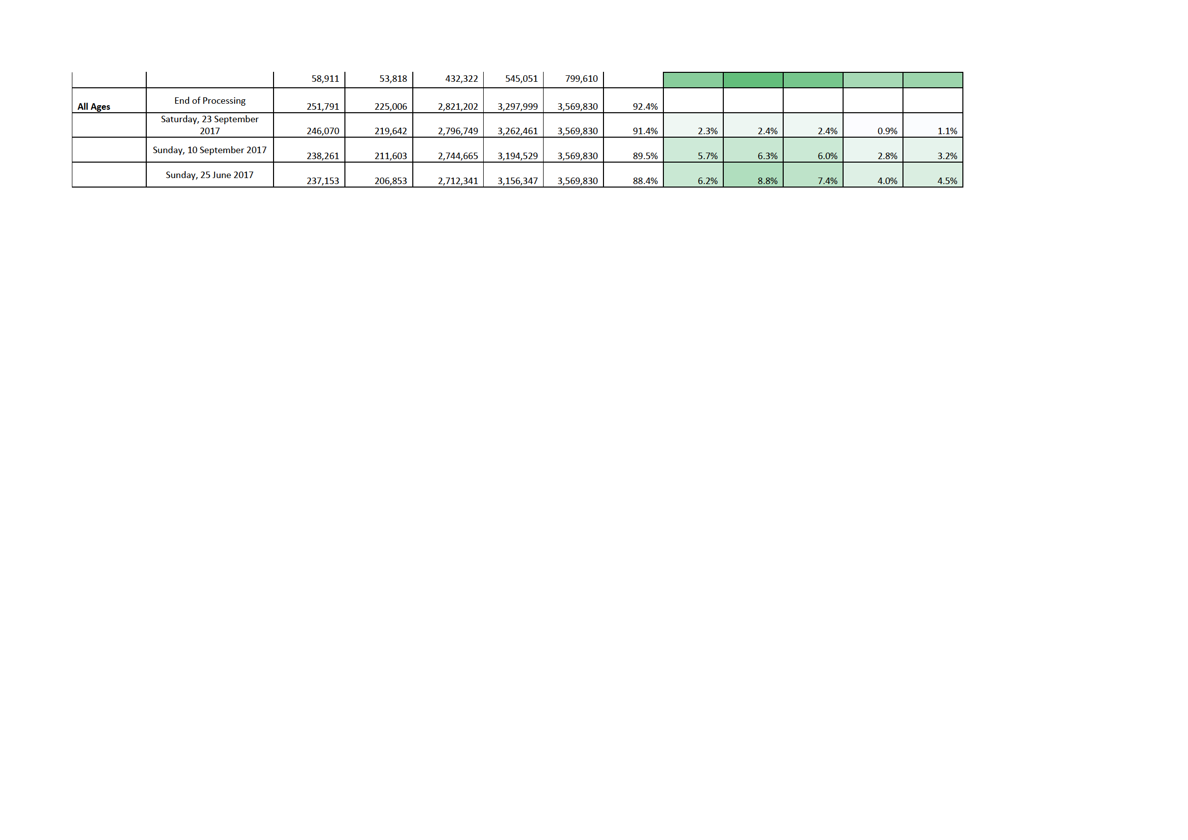
• Official count progress is included at the end of the SITREP.
Enrolment
GENERAL UPDATE:
• Enrolment form processing is complete, and the team has moved onto Special Vote Declarations (SVDs).
• As at midday today, there were 131,503 SVD forms in the enrolment queue for processing. 11,413 have been
processed and await the second check.
• As at midday we have not received any SVDs from electorates 46 (Southland), 59 (Waitaki) and 66 (Hauraki-
Waikato).
• Note that individual forms are returned to Electorate HQ as they are completed. We process a form from the
SVD queue (from the batch sent through to us), it then goes into the "second check" queue. Once the second
check is completed the form is immediately returned to VS.
• Some SVD forms within a batch may be processed slightly differently, as they require a manual qualification


UNCLASSIFIED
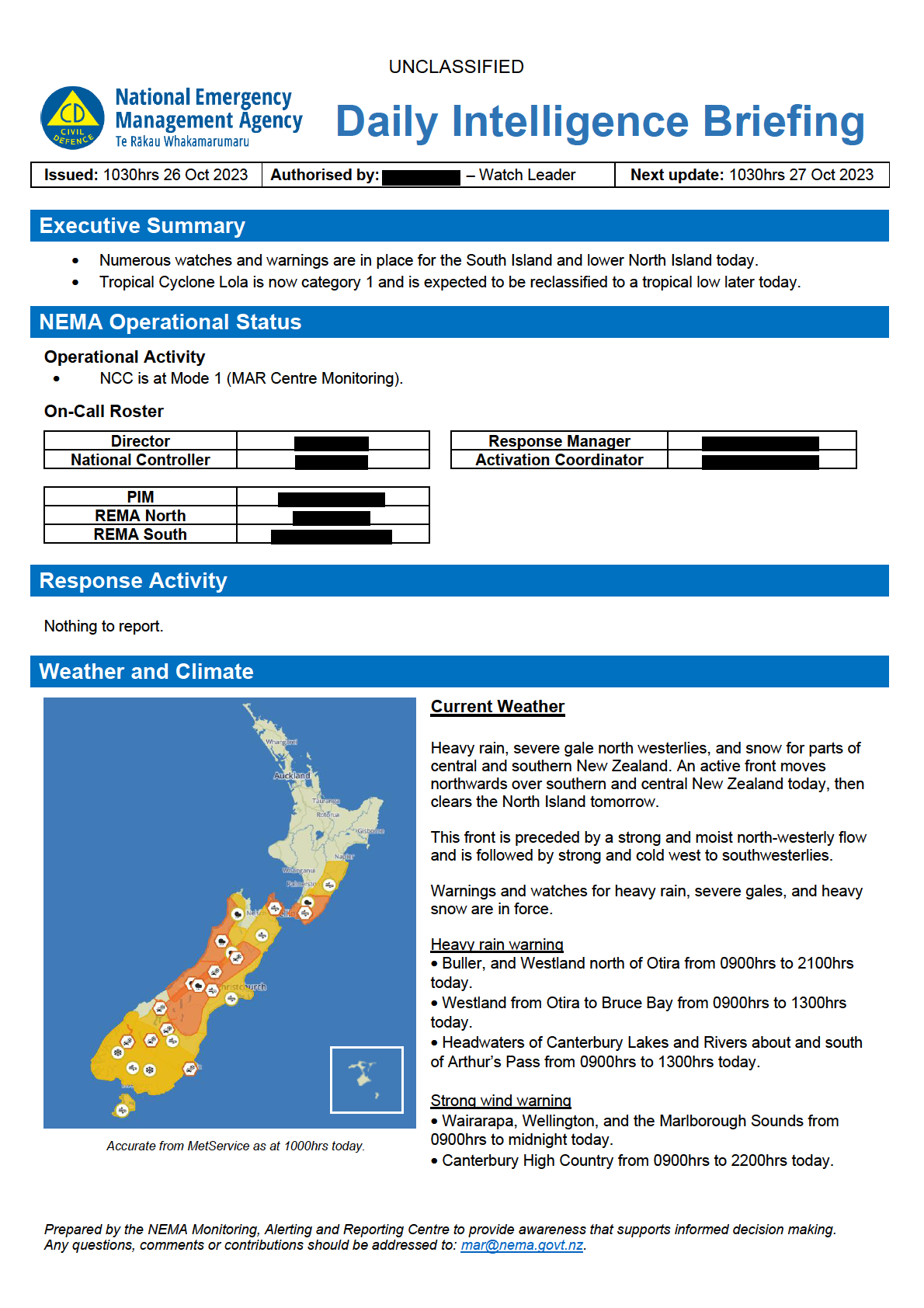
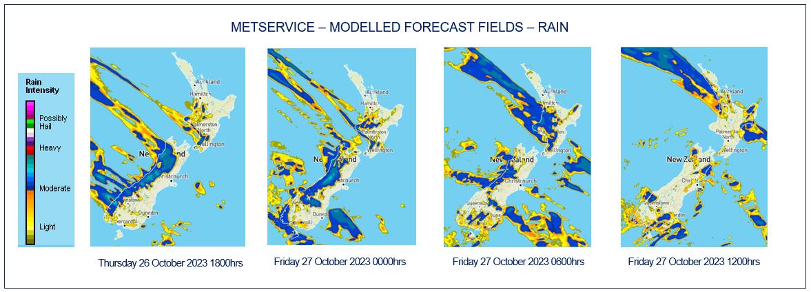
Heavy rain watches have been issued for: Tararua Range, The ranges of Tasman west of Takaka, Nelson Lakes, and
the headwaters of the Canterbury lakes and rivers north of Arthur's Pass within 25 km east of the main divide.
Strong wind watches have been issued for: Hawke's Bay south of Hastings, and the Tararua District, Marlborough
excluding the Sounds, Canterbury excluding the High Country, Otago excluding Clutha, Clutha, Southland, Stewart
Island and Fiordland.
Heavy snow watches have been issued for: Fiordland, Southland, Clutha, Dunedin, Central Otago and Queenstown
Lakes.
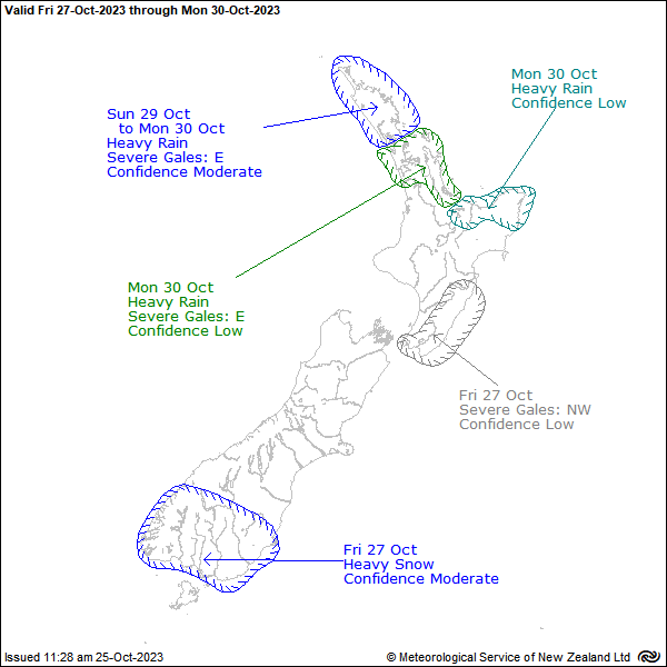
Severe Weather Outlook
A front preceded by strong west to northwest winds
moves north over the North Island tomorrow, and a
very cold south to southwest flow over the South
Island spreads over the North Island following the
front. Bitterly cold south to southwest winds and snow
to sea level are expected in the south of the South
Island.
Tomorrow sees a moderate confidence for heavy
snowfall in Southland reaching warning criteria.
Tomorrow also brings a low confidence for severe
gales in and around the Wellington region.
Monday sees the beginning of the next rain band
impacting the upper North Island, bringing moderate
to low confidences of heavy rain and severe gales.
Prepared by the NEMA Monitoring, Alerting and Reporting Centre to provide awareness that supports informed decision making.
Any questions, comments or contributions should be addressed to: [email address].


UNCLASSIFIED
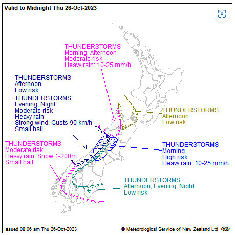
Thunderstorm Outlook
With the current forecasted weather, comes some risk of
thunderstorms.
There is a high risk of thunderstorms this morning for parts
of the West Coast and Canterbury High Country. The rest
of the west coast of the South Island can expect up to a
moderate risk of thunderstorms through various parts of the
day today.
For parts of South these thunderstorms may bring brief
heavy rain, hail and snow lowering to 100-200m.
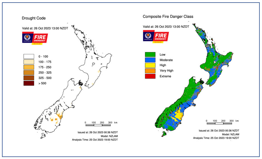
Fire and Drought Risk
Source: NIWA Fire Weather
Prepared by the NEMA Monitoring, Alerting and Reporting Centre to provide awareness that supports informed decision making.
Any questions, comments or contributions should be addressed to: [email address].
