25/10/2023 - E +11 SITREPS
As at 9.43am on 25/10/2023 prepared by Crispian
Distributed
All GEDT/ELT members
to
Key
Anusha Guler and Crispian
Contacts
Previous
E+10 SITREPS 7 24102023 - FINAL.docx
ELT SITREP
Opening Karakia: Pou Hihiri. Pou Rarama.
Tena te pou,
Te Poutokomanawa o tēnei whare
Te pou Tūhonohono
Te pou Arataki
Te pou Uakaha
Te pou Manaaki
Te pou o te Tika
Te pou ka toko, ka hiki, ka eke.
Ū te pou. Maia te pou. Rarawe te pou
Hui te mārama. Hui te ora.
Whano, whano! Haramai te toki – Haumi e!
Hui e – Tāiki e!
Overview
Summary of the current event
• Post election process
Voting
GENERAL UPDATE
Services
Overseas Operations
•
Auckland North Region
•
Auckland South Region
•
Central North Island Region
•
Lower North Island Region
•
South Island Region
•
Voting Services:
•
Enrolment
GENERAL UPDATE:
•
IT
GENERAL UPDATE: • .
Comms &
GENERAL UPDATE:
Education
•
Customer
GENERAL UPDATE:
Services
•
Legal &
GENERAL UPDATE
Policy
•
Strategic
GENERAL UPDATE
Engagement
•
and
Partnership
Security
GENERAL UPDATE
•
People &
GENERAL UPDATE:
Culture
• .
Closing Karakia:
Koia tēnei te whakairi ake i te kete whakaaro, i te kete kōrero ki te epa o te whare
Karakia whakamutunga
Tēnei te whakamoe tai o tēnei o ngā whare kōrero
Whakamoe tai
Whakamoe ahiahi/kaupapa
Whakamoe tēnei whare kōrero
Ko Io te pū, Io tā koutou weu, Io tā koutou tāmore
Tēnei te hau
Tēnei te hau kiwi, te hau weka
Tēnei te hau ka kawea mai, ka tau mai, ka mārire mai, ka māhaki mai
Māhaki ki te rangi
Māhaki ki te whenua
Māhaki ki ngā tāngata katoa
E Rongo, whakairihia te kete kōrero ki runga, kia Tina – Tina!
Hui e – Tāiki e!


UNCLASSIFIED
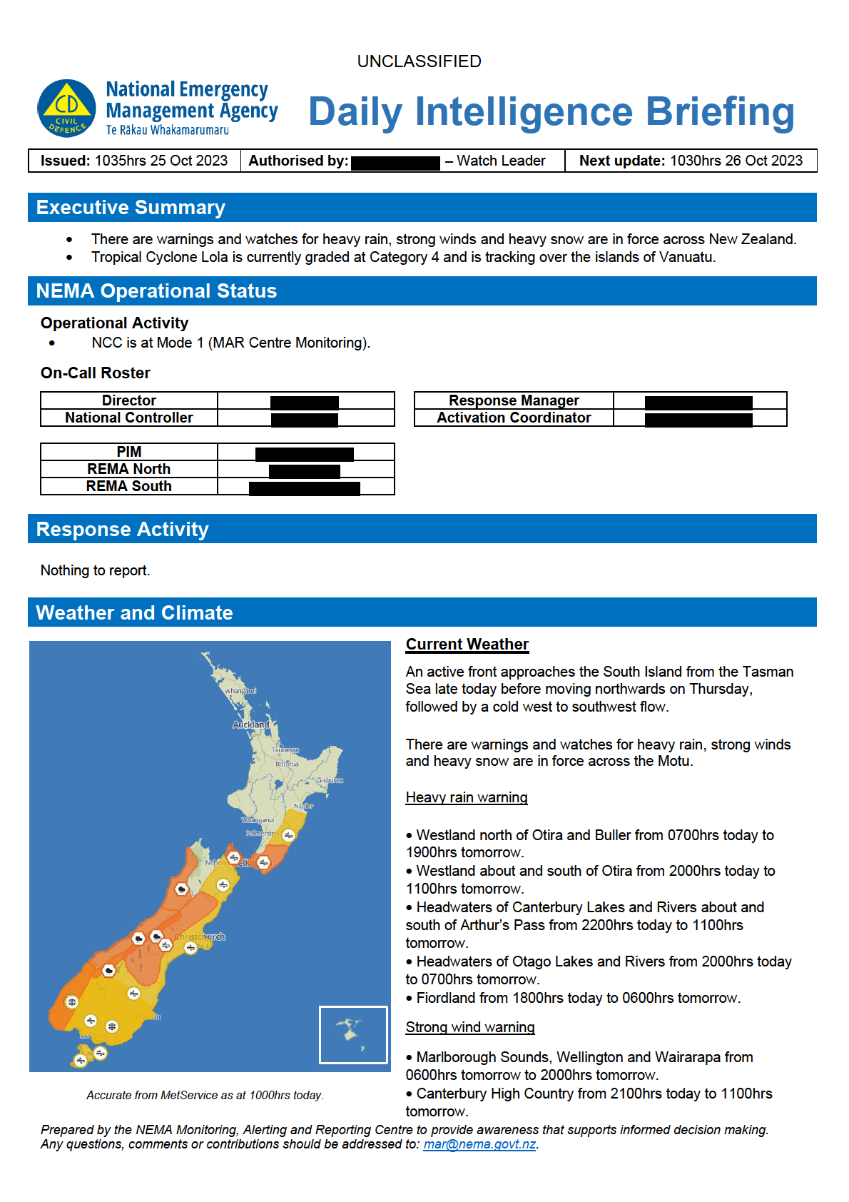
Strong wind watches
• Tararua District and Hawke’s Bay south of Hastings from 0900hrs tomorrow to 2300hrs tomorrow.
• Marlborough excluding the Sounds from 0600hrs tomorrow to 1800hrs tomorrow.
• Canterbury Plains including Banks Peninsula from 0600hrs tomorrow to 1800hrs tomorrow.
• Otago excluding Clutha from 2000hrs today to 1100hrs tomorrow.
• Clutha, Southland, Stewart Island and Fiordland from 1500hrs today to 1100hrs tomorrow.
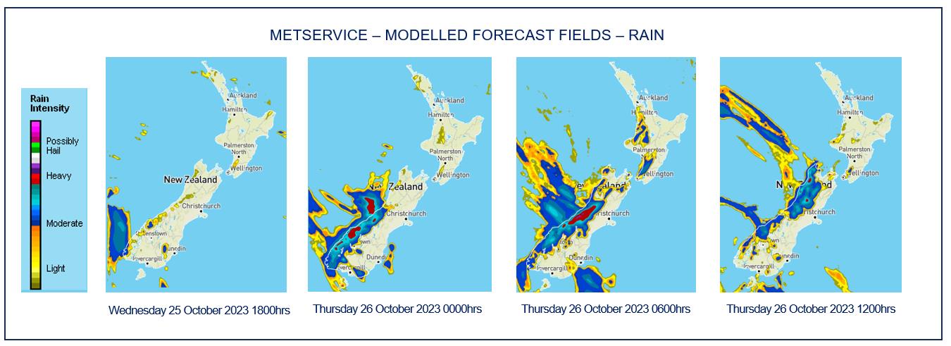
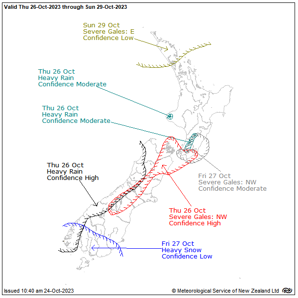
Severe Weather Outlook
On Thursday, a front moves northeast over the South
Island and onto the lower North Island, followed by a
cold southwesterly flow. There is high confidence that
rainfall accumulations will reach warning amounts in
Fiordland, Westland, Buller and the headwaters of the
Otago and Canterbury lakes and rivers. There is high
confidence in severe northwest gales for exposed
parts of the Canterbury high country and foothills,
Marlborough, Wellington and Wairarapa south of
Carterton. There is moderate confidence that rainfall
over Mt Taranaki and the Tararua Range will reach
warning amounts.
A strong cold southwesterly flow is expected to affect
the South Island on Friday. Snow showers could lower
to near sea level over parts of the South Island. There
is low confidence in warnings amounts of snow for
Clutha, Southland and the south of Fiordland. While
warning amounts of snow are not expected farther
north over the South Island, there is still a risk that
roads will be affected by snow. The strong
southwesterly winds, cold temperatures and snow to
low levels is likely to affect the entire South Island,
possibly bringing stress to livestock.
On Friday, there is moderate confidence that severe northwest gales will affect Wellington and Wairarapa including the
Tararua District. A ridge of high pressure is expected to bring settled weather to New Zealand on Saturday.
A ridge of high pressure is expected to bring settled weather on Saturday.
Prepared by the NEMA Monitoring, Alerting and Reporting Centre to provide awareness that supports informed decision making.
Any questions, comments or contributions should be addressed to: [email address].


UNCLASSIFIED
On Sunday, an area of low pressure may approach the North Island from the north, possibly Tropical Cyclone Lola. It is
important to note the current uncertainty associated with the development and movement of Tropical Cyclone Lola.
Refer to ‘Other Events’ for the most up-to-date information.
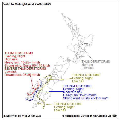
Thunderstorm Outlook
An unstable westerly flow covers the central and
southern North Island this morning as an upper cold
trough moves across the area. There is a low risk of
thunderstorms about ranges from the Kaimanawas to
the northern Tararuas, southern Gisborne, Hawke’s
Bay and Tararua District this morning.
Later today, a front and associated rain-band in the
Tasman Sea will move onto the southern South Island.
There is a high risk of thunderstorms within the rain-
band about the mountains of northern and central
Fiordland from this evening, and a moderate risk of
thunderstorms spreading into southern Fiordland, far
western Southland and Otago headwaters. There is a
lower risk of thunderstorms about other parts of
Southland, southern Westland and the southern
Canterbury High Country from late evening.
These thunderstorms will boost local rainfall rates,
mainly in the 15-25mm/h range, but there is a low risk
of 25-35mm/h downpours associated with the
thunderstorms about the Fiordland mountains. The
thunderstorms will also be embedded within a strong
northwest flow, so gusts of 90-110km/h are possible, however as the storms are elevated, they are not expected to
contribute any extra wind gusts.
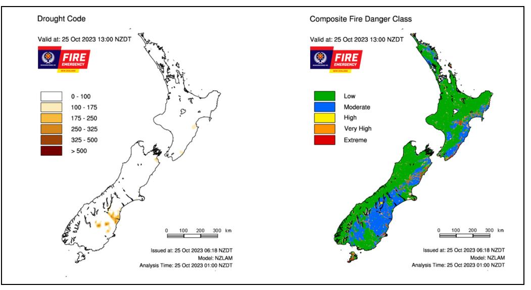
Fire and Drought Risk
Prepared by the NEMA Monitoring, Alerting and Reporting Centre to provide awareness that supports informed decision making.
Any questions, comments or contributions should be addressed to: [email address].
