
SUBMISSION 162
Form 5
Submission on notified proposal for plan change
Clause 6 of Schedule 1, Resource Management Act 1991
To: Upper Hutt City Council
Name of submitter: Guildford Timber Company Limited, Silverstream Forest Limited and
the Goodwin Estate Trust
This is a submission on the following plan change proposed to the Operative District Plan for
Upper Hutt (the
proposal):
• Proposed Plan Change 50 (PC50)
The submitters could not gain an advantage in trade competition through this submission.
The specific provisions of the proposal that the submission relates to are:
• The failure to include land owned by the Guildford Timber Company Limited,
Silverstream Forest Limited and the Goodwin Estate Trust in the review of rural
zones undertaken as part of PC50;
• The need to rezone parts of the Guildford Timber Company, Silverstream Forrest
Limited and the Goodwin Estate Trust’s land to General Residential or Rural
Lifestyle (including a new special Precinct for land adjoining Avro Road) to allow the
planned use and development of the submitter’s land; and
• The need to include a number of minor amendments to the Rural Lifestyle Zone to
allow for planned use and development in the proposed new Avro Road Precinct.
The submitters support the rezoning of some of its land to Rural Lifestyle included in PC50.
We seek the following decision from the Upper Hutt City Council:
Refer to submission attached.
As this is a rezone request the submitters requests that the Council take active steps to draw
this submission to the attention of all persons who may consider themselves adversely
affected by the relief sought in this submission to ensure that they are aware of the rezoning
request as part of Plan Change 50 and that they have had sufficient opportunity to file a
further submission if they so wish. The Submitter is prepared to work with Council Officers
to ensure this is achieved.
We wish to be heard in support of our submission.
1
Person authorised to sign
on behalf of Guildford Timber Company Limited, Silverstream Forest Limited and Goodwin
Estate Trust
Date: 17 November 2023
Electronic address for service of submitters: s7(2)(a)
Telephone: s7(2)(a)
Contact person: Chris Hansen, RMA Planning Consultant
2
Submission on notified Proposed Plan Change 50 (PC50)
Overview
The following submission is on behalf of the Guildford Timber Company Limited,
Silverstream Forests Ltd, and the Goodwin Estate Trust (submitters) who own land in
Pinehaven/Silverstream, Upper Hutt. The land the subject of this submission is currently
zoned General Rural in the Operative District Plan and therefore is able to be considered by
Proposed Plan Change 50 (PC50).
There are also a small number of lots owned by the submitters that PC50 rezones as Rural
Residential, as identified on the Map 1 in Appendix A, and the submitters support the
rezoning of those lots.
The Guildford Timber Company Limited is a family-owned company that was established in
1926. It has a 90+ year history and association with Upper Hutt and with Pinehaven and
Silverstream. The submitters own approximately 330ha of land in the Silverstream/
Pinehaven area that is held in multiple titles (refer to Map 1 in Appendix A). Its land
comprises the steeper slopes surrounding existing residential areas, and the rolling ridges
around the southern and eastern sides of the Pinehaven Valley, extending over into Blue
Mountains.
Since 1928 the land has primarily been used as a commercial pine plantation. The submitters
have called its forestry operation Silverstream Forest Ltd. Large areas of this mature
production forest (pines) is due to be harvested in the short-medium term.
The submitters intend to develop parts of its land for residential and mixed-use activities as a
post-harvest use of the land. The submitters have been working towards the transitioning
from forestry land to residential and mixed-use development with the Upper Hutt City
Council (UHCC) for almost two decades (as outlined below in this submission).
PC50 does not in its current form include provisions that enable parts of the submitter’s land
to be used for residential and mixed-use activities as planned by the submitters working with
the UHCC. The purpose of this submission is to address this lack of provision to develop the
submitter’s land. The submitters therefore oppose PC50 in its current form.
Planning Context
UHCC initial introduced PC50 in September 2020 and intended to review the residential and
rural provisions of the Operative District Plan, as part of a rolling plan review process.
Subsequent to seeking community input on PC50, the Government introduced through the
National Policy Statement – Urban development (NPS-UD) compulsory rules and standards
for residential subdivision and development (Medium Density Residential Standards known
as MDRS) and required Council to incorporate these provisions into the district plan by a set
timeframe. As a result, UHCC proceeded with the residential review of provisions through
3
an Intensification Planning Instrument (IPI) as one part of PC50 (with a Decision on this part
of PC50 due shortly), and delayed the rural review of provisions part of PC50 until October
2023.
The following other planning instruments are relevant to this submission:
• National Policy Statement – Urban Development 2020 (NPS-UD) - a key Objective of
the NPS-UD is to ensure New Zealand has well-functioning urban environments that
enable all people and communities to provide for their social, economic, and cultural
wellbeing, and for their health and safety, now and into the future. Regional and district
plans are required to implement this objective.
• Wellington Regional Growth Framework 2021 and draft Future Development Strategy
(FDS) 2023 – the submitter’s land was previously included as a Southern Growth Area
in Wellington Regional Future Growth Framework (2021). However, the draft FDS1
(PPC1 to the Natural Resources Plan) does not include the submitter’s land as a Future
Growth Area. The submitters have filed a submission2 to GRWC seeking the
reinstatement of its land as a Future Growth Area as included in the previous Regional
Growth Strategy, Upper Hutt City Council has supported this submission.
• UHCC Land Use Strategy 2016 – 2043 (LUS) - the submitter’s land is identified in the
Council’s LUS as the Southern Growth Area.
• UHCC Long Term Plan 2021 - 2031 (LTP) (adopted 2022) the submitter’s land is
identified in the Council’s LTP as the Southern Growth Area and is recognised and
accounted for in the planning for public infrastructure upgrades for growth planning
purposes. In particular:
o Silverstream bridge replacement being required due to growth in central Upper Hutt
and the southern growth zone. Infrastructure upgrades to the bridge was planned for
years 4-10.
o Pinehaven reservoir upgrades for water supply were required for growth in years
11-20
Both of these investments require significant capital investment but have been planned
for in the LTP and planned to allow for medium term growth.
• UHCC Plan Change 43 (stormwater/ flooding) and associated works, and Proposed
Plan Change 49, Variation 1 to provide to infrastructure and services (discussed further
below)
1 Wairarapa – Wellington – Horowhenua Future Development Strategy; September 2023
2 Submissions closed Thursday 9 November
4
Brief History of Planning for the Use and Development of the Land
The submitter’s have worked with UHCC to plan for residential and mixed use development
of part of their land known as the Southern Growth Area since 2007 and this planning is
reflected in the various planning instruments discussed above that anticipate future residential
and mixed use activities on the land. The submitter’s have a vision for the development being:
To provide a quality residential development that meets best practice urban design
standards and delivers on the wider community needs in Pinehaven and Silverstream
through provision of housing and allowing submarginal rural land to be either
replanted for ecological restoration and improve parks and reserve assets.
This vision is driven by providing walkable village hubs with compact and well-designed
housing and community spaces. Important ecological areas are identified and enhanced,
infrastructure including roading and 3 waters provided, and stormwater and flooding managed
to achieve hydraulic neutrality on the land.
The submitter’s land has been through two masterplan processes first in 2007 and more recently
in 2021 – the Silverstream Forest Masterplan. It has also been the subject of a joint
Infrastructure Accelerator Fund application with UHCC in 2020 which included assessments
for all required infrastructure and demonstrated that the land could be serviced.
Planning for infrastructure to support the submitters has been undertaken at a plan level by
UHCC via Plan Change 43 (stormwater/ flooding) and associated works, Proposed Plan
Change 49, Variation 1 to provide to infrastructure and services (roading access, utilities,
network utilities and water reservoirs for the Southern Growth Area and provision for growth
related infrastructure (water reservoir and Silverstream bridge upgrade) including expenditure
for this infrastructure in the UHCC LTCP 2021-2035 (adopted in 2022).
It proposed development would provide a significant number of additional dwellings of up to
1600 households, of varying typologies, and considerable testing has been undertaken in the
concept plan to confirm whether affordable housing could be provided within each of the
village hubs proposed in the growth area which are high quality and meet good urban design
principles.
The land sits between Silverstream and Upper Hutt City’s existing urban areas and is able to
be well connected with commuter cycling connections, connections to the Silverstream
Railway Station and provision of recreational tracks for all residents through the area. The
proposed development would focus on urban form and street design around public transport
nodes and further strength economic activity within the Silverstream Town Centre, meeting
the FDS prioritised Development Area assessment criteria.
Submission
The submitters cannot understand why their land, which has previously been identified as a
future growth area and has had significant investigations for its future use and development (as
outlined above), was not included as part of the current rural zoning review undertaken as part
of PC50, particularly as the land has been recognised by Council as the Southern Growth Area
5
in previous Council documents (as discussed above). The submitters have invested significant
time and money on expert assessments to date to support the rezone. The submitters consider
this a major oversight that needs to be rectified by Council through this submission.
The submitters note that PC50 changes the zoning of a number of properties from General
Rural to General Residential, and from General Rural to Rural Lifestyle.3
The submitters have demonstrated the suitability of its land for residential and mixed use
activities through the extensive planning undertaken since 2007, and the significant economic
and social benefits to the wider community, including affordable housing, recreational
opportunities, and ecological enhancement of important areas. The summary of this work
was provided in the Framework Document for the submitters4 which is publicly available.
The technical reports that underpinned this work included:
• Transport Modelling
• Electricity supply
• Stormwater
• Wastewater and water supply and other services
• Reverse sensitivity assessments
• Ecology
• Feasibility cost estimates
• Urban design
• RMA planning
• Consultation with relevant stakeholders and the wider community
The submitters consider it is appropriate based on the planning history of its land for the
following rezoning approach to be incorporated into the District Plan through PC50. The
Masterplan identifies four distinct areas that will allow for the future use and development of
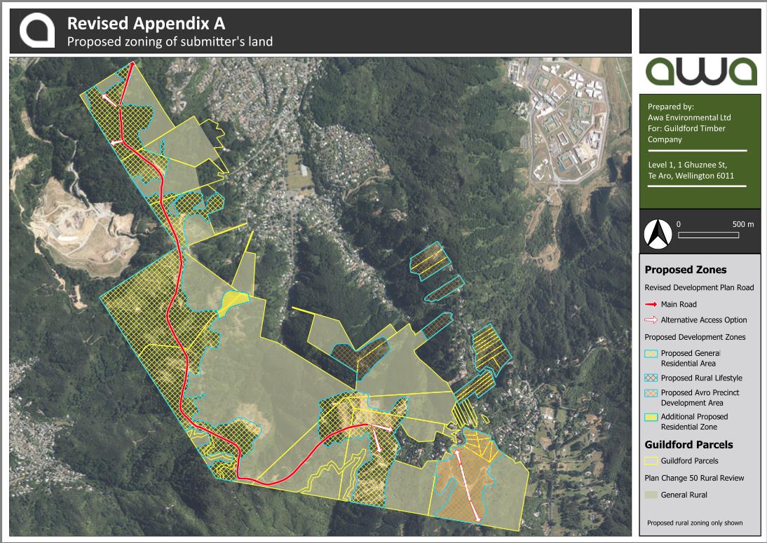
its land as shown on Map 1 included in Appendix A and described further below. The
submitters propose the following planning approach to each of these four areas:
Ridgeline Areas
Ridgeline Areas have been identified in the submitter’s development planning for ‘village
hubs’ that provide for residential and mixed use activities linked by road and 3 waters
infrastructure. These areas are shown as yellow cross-hatched on Map 1 in Appendix A. The
submitters propose the Ridgeline Areas be rezoned from General Rural to General
Residential and be subject to the MDRS provisions incorporated into the district plan through
the IPI component of PC50.
Small Rural Lifestyle Areas adjoining Blue Mountains Road
There are a number of small lots near to and adjoining Blue Mountains Road and the
submitters propose these areas be rezoned from General Rural to Rural Lifestyle. These
areas are shown as brown cross-hatched on Map 1 in Appendix A and are outside of the area
3 Appendix 1 to the s.32 Evaluation Report; October 2023
4 guildford-timber-company-framework-document-2007.pdf (upperhuttcity.com)
6
covered by the 2021 Silverstream Forest Masterplan. Rezoning these lots to Rural Lifestyle
is consistent with the existing pattern of rural residential land use within the existing General
Rural Zone along the Blue Mountains Road, and is consistent with the pattern of
development along Avro Road where PC50 changes the zoning of similar sites from General
Rural to Residential Lifestyle.
The submitter’s support the rezoning of the remainder of the small lots adjoining Blue
Mountains Road (shown on Map 1 in Appendix A) as proposed in PC50.
Large Lifestyle Area adjoining Avro Road
A larger area currently zoned General Rural adjoins Avro Road as shown orange cross-
hatched on Map 1 in Appendix A. The submitters propose this area be rezoned Rural
Lifestyle and be subject to the provisions of a new Avro Road Precinct. The purpose of this
new Precinct is to provide a gateway to the southern end of the new use and development and
to provide a lower level of residential density than proposed in the General Residential Zone
in the Ridgeline Areas to transition to the adjoining Rural Lifestyle Zone. The new Precinct
also and adjoins land identified as having important ecological values.
While the detail of the new Avro Road Precinct have yet to be developed, it is proposed the
residential activity would be a cluster development with a maximum of 12 dwellings per
hectare. This housing typology would be planned and designed to fit into the landscape
surrounding the new Precinct.
Bespoke provisions will be prepared for this new Avro Road Precinct and provided to the
hearings, that would include (but not limited to):
• A new subdivision objective and policy specific to the Avro Road Precinct;
• Inclusion in the subdivision standards for restricted discretionary activities that will
set minimum allotment sizes and the maximum number of lots for subdivision in the
Avro Road Precinct;
• New rules in the Rural Lifestyle Zone providing for the cluster residential activity
with a maximum of 12 dwellings per hectare as a restricted discretionary activity;
• Exemption from the traffic generation requirements for the Rural Lifestyle Zone
included in TP-S9;
• Other consequential amendments that may be required to enable the proposed use and
development in the Avro Road Precinct.
The submitter’s have considered the appropriateness of seeking Avro Street land be rezoned
Settlement Zone with amendments to allow the cluster housing development proposed.
However, the submitters consider the purpose or provisions of the Settlement Zone intends
the residential typology proposed. Notwithstanding this, the submitter’s are open to
discussing alternative planning mechanisms for achieving the outcomes sought for the Avro
Road land if a Precinct approach is not accepted..
Remainder of the Site
The remainder of the submitter’s land is a mix of some production forestry, identified
important ecological values and areas of high recreational value to the wider community as
7
shown green on Map 1 in Appendix A. The submitters propose to retained this area in the
General Rural Zone.
The submitters will provide the following information to the hearing to support the above
proposals:
- Technical Reports assessing the effects associated with the rezoning and the new
Avro Road Precinct proposed above:
o Traffic and Transportation.
o Landscape/visual effects.
o Ecological effects.
o Archaeological effects.
o Stormwater and flood hazard.
o Geological.
o Infrastructure – servicing/earthworks.
o Economic.
o Urban design.
o Reverse sensitivity effects from the landfill.
o Cultural effects.
o S32A Evaluation.
- Detail regarding the residential and mixed use development proposed in the Ridgeline
Areas to be rezoned General Residential;
- Detail regarding the type of residential development proposed in the small Rural
Lifestyle Zone with access to Blue Mountains Road;
- Detail regarding the bespoke provisions to be included in the Avro Road Precinct in
the larger Rural Lifestyle Zone adjoining Avro Road.
Decision Sought
The submitters seek Council to incorporate the following approach to rezone its land at
Pinehaven/Silverstream in PC50:
1. The Ridgeline Areas of the submitter’s land identified on Map 1 in Appendix A
suitable for residential and mixed use activities be rezoned General Residential:
2. The Small Rural Lifestyle Areas of the submitter’s land near and adjoining Blue
Mountains Road identified on Map 1 in Appendix A be rezoned from Rural Lifestyle;
3. The rezoning of the remainder of small lots adjoining the Blue Mountains Road to
Rural Lifestyle proposed in PC50 be adopted;
4. The larger Rural Lifestyle Area adjoining Avro Road identified on Map 1 in
Appendix A be rezoned Rural Lifestyle and be subject to the provisions of a new
Avro Road Precinct as outlined above;
5. Consequential amendments to the relevant District Planning Maps to include the
above rezoning and precinct requests;
6. Any further consequential amendments or other amendments to the Operative District
Plan considered necessary to achieve the intention of this submission request to better
provide for residential and mixed use activities on the submitter’s land.
8
APPENDIX A – Map 1 – Proposed rezoning of submitter’s land
9

10
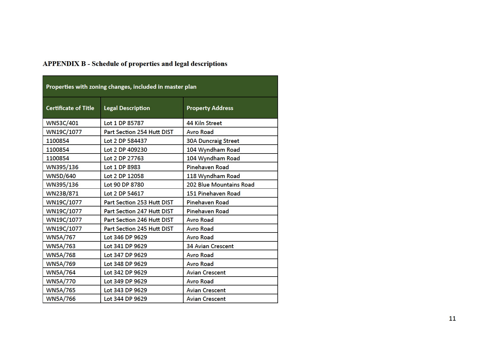
WN5D/652
Lot 27A DP 8777
139 Blue Mountains Road
WN6B/62
Lot 27 DP 8777
141 Blue Mountains Road
WN6B/63
Lot 28 DP 8777
143 Blue Mountains Road
WN6B/64
Lot 470 DP 9755
169 Blue Mountains Road
WN6B/65
Lot 471 DP 9755
171 Blue Mountains Road
WN6B/66
Lot 472 DP 9755
173 Blue Mountains Road
WN6B/67
Lot 473 DP 9755
175 Blue Mountains Road
WN6B/68
Lot 474 DP 9755
177 Blue Mountains Road
WN6B/69
Lot 475 DP 9755
179 Blue Mountains Road
WN6B/70
Lot 476 DP 9755
181 Blue Mountains Road
WN6B/72
Lot 478 DP 9755
185 Blue Mountains Road
WN6B/71
Lot 477 DP 9755
183 Blue Mountains Road
WN5A/733
Lot 269 DP 9629
222 Blue Mountains Road
WN5A/732
Lot 268 DP 9629
224 Blue Mountains Road
WN5A/731
Lot 267 DP 9629
226 Blue Mountains Road
WN5A/730
Lot 266 DP 9629
228 Blue Mountains Road
WN5A/729
Lot 265 DP 9629
230 Blue Mountains Road
WND3/938
Lot 32 DP 8777
151 Blue Mountains Road
12

Form 5
Submission on notified proposal for plan change
Clause 6 of Schedule 1, Resource Management Act 1991
To: Upper Hutt City Council
Name of submitter: Guildford Timber Company Limited, Silverstream Forest Limited and
the Goodwin Estate Trust
This is a (late) submission on the following plan change proposed to the Operative District
Plan for Upper Hutt (the
proposal):
• Proposed Plan Change 50 (PC50)
The submitters could not gain an advantage in trade competition through this submission.
The specific provisions of the proposal that the submission relates to are:
• The submitters provided a detailed submission on PC50 that requested the rezoning of
parts of its land in Pinehaven from Rural to General Residential;
• The original submission included in
APPENDIX A – Map 1 - Proposed zoning of
submitter’s land a map showing the proposed rezoning of the submitter’s land,
including the area requested to be rezoned from Rural to General Residential;
• Map 1 requires a minor correction as it inadvertently left off a small area of land east
of the main hilltop area the submitter’s are seeking to be rezoned from Rural to
General Residential;
• Attached is a
REVISED APPENDIX A – Map 1 - Proposed zoning of submitter’s
land map that correctly shows the area to be rezoned – the additional area is coloured
yellow.
We seek the following decision from the Upper Hutt City Council:
Replacement of
APPENDIX A – Map 1 - Proposed zoning of submitter’s land included in
the submitter’s original submission with the
Revised Attachment A – Map 1 - Proposed
zoning of submitter’s land attached to this late submission
We wish to be heard in support of our submission.
Person authorised to sign
on behalf of Guildford Timber Company Limited, Silverstream Forest Limited and Goodwin
Estate Trust
1
Date: 26 January 2024
Electronic address for service of submitters: s7(2)(a)
Telephone: s7(2)(a)
Contact person: Chris Hansen, RMA Planning Consultant
2
REVISED APPENDIX A – Map 1 – Proposed rezoning of submitter’s land
3
4