

RELEASED UNDER THE
OFFICIAL
Geographic and property
information
INFORMATION
Land Information Portfolio
ACT
November 2023
link to page 3 link to page 5 link to page 5 link to page 6 link to page 7 link to page 7 link to page 8 link to page 9 link to page 9 link to page 13 link to page 13 link to page 18 link to page 19 link to page 21 link to page 23 link to page 23 link to page 23 link to page 27 link to page 28 link to page 29 link to page 31
Geographic and property information
Contents
1
Introduction ............................................................................................................................. 3
2
Your role as Minister for Land Information .......................................................................... 5
2.1 Ensuring LINZ maintains and improves geographic and property information ................................ 5
RELEASED
OFFICIAL
2.2 Overseeing the delivery of SouthPAN ................................................................................................................ 6
2.3 Roles relating to Ngā Pou Taunaha o Aotearoa New Zealand Geographic Board ........................... 7
2.4 Appointing people to statutory boards ............................................................................................................. 7
2.5 Considering improvements to the valuation regime .................................................................................... 8
3
LINZ’s activity in the geographic information regime ......................................................... 9
3.1 Collecting, managing and publishing information ........................................................................................ 9
3.2 Maintaining New Zealand’s positioning infrastructure .............................................................................. 13
3.3 SouthPAN project to improve positioning data ........................................................................................... 13
INFORMATION
3.4 Administering Ngā Pou Taunaha o Aotearoa New Zealand Geographic Board ............................. 18
UNDER
3.5 Improving New Zealand’s preparation and response to emergency events .................................... 19
3.6 Preparing for a transformation to fully digital maritime navigation .................................................... 21
4
LINZ’s activity in the property information regime ........................................................... 23
4.1 Property information ............................................................................................................................................... 23
4.2 Administering the valuation regime .................................................................................................................. 23
5
Outlook for geographic and property information ............................................................ 27
THE
6
Next steps .............................................................................................................................. 28
Annex 1 Critical relationships ........................................................................................................ 29
Annex 2 Board membership .......................................................................................................... 31
ACT
2
Geographic and property information
1 Introduction
This briefing on geographic and property information supplements your initial briefing on
the Land Information portfolio.
Providing geographic and property information is one of four regimes covered in
RELEASED
OFFICIAL
supplementary briefings.
Figure 1: LINZ regimes covered in supplementary briefings
Regimes
Main activities
Main legislation
Overseas
Ensure permitted investments in New
Overseas Investment Act 2005
investment
Zealand’s sensitive assets by overseas
persons provide net benefits to New
Zealand
Property rights
Administer a state-guaranteed
Cadastral Survey Act 2002, Land
INFORMATION
regime of property rights, restrictions
Transfer Act 2017
and responsibilities over land and
UNDER
property in New Zealand
Geographic and
Providing information that New
Valuers Act 1948, Rating
property
Zealanders value when making land,
Valuations Act 1998, New
information
sea and property-related decisions,
Zealand Geographic Board (Ngā
as well as informing local and central
Pou Taunaha o Aotearoa) Act
government decision-making on
2008
issues like emergency response and
THE
climate change.
Crown land
Administer Crown land, and the
Land Act 1948, Public Works Act
regime for acquiring and disposing
1981, Crown Pastoral Land Act
of land in a way that balances both
1998
the public interest and private
ACT
property rights
This briefing discusses:
• your role in relation to geographic and property information
• activity in the geographic information regime
• activity in the property information regime
• the outlook for geographic and property information
• suggested next steps.
3
Geographic and property information
Facts at a glance
2,000+
160
authoritative geographic and
Notices to Mariners were issued
RELEASED
OFFICIAL
property datasets, 480 topographic
last year, providing updates to
maps and 525 nautical charts
charts and advising navigational
produced for New Zealand, some
hazards.
Pacific Islands and the Ross Sea
region of Antarctica.
12
100,000+
key datasets created for the
Resilience and Climate Change Key
registered users of the LINZ Data
Dataset Improvement Programme.
INFORMATION
Service (which provides free online
access to New Zealand’s most up-
UNDER
to-date land and seabed data).
80%
of New Zealand will be captured by
3D mapping as part of the national
light detection and ranging (LiDAR)
project.
THE
ACT
4
Geographic and property information
2 Your role as Minister for Land Information
Your main roles in relation to geographic and property information are ensuring
Toitū Te Whenua Land Information New Zealand (LINZ) maintains and improves
geographic and property information, overseeing the delivery of SouthPAN, roles
RELEASED
OFFICIAL
relating to Ngā Pou Taunaha o Aotearoa New Zealand Geographic Board,
appointments to statutory boards and considering improvements to the valuation
regime.
2.1 Ensuring LINZ maintains and improves
geographic and property information
The geographic and property information held by LINZ is a valuable government asset
that has been built up over a long period.
INFORMATION
You have a role in ensuring that LINZ:
• promotes the use of LINZ’s geographic and property data by central and local
UNDER
government to make informed decisions on policy, services and investment
• leads the management and amalgamation of geographic and property data
across government (and continues to take a more formal role as functional lead
across government, seeking efficiencies and consistency across agencies)
• identifies new opportunities to improve decision-making and services through
the use of geographic and property information as you introduce new policies
and priorities.
THE
New Zealanders, businesses, communities, and government rely on and use geographic
and property data every day (
Annex 1). The data is used on its own and in combination
with other data, supporting innovation and many economic, social, and environmental
decisions:
• Waka Kotahi New Zealand Transport Agency (NZTA) and councils use geographic
ACT
and property data to decide where to invest in roading infrastructure.
• Elections are supported by data on electoral boundaries.
• Farmers use detailed land information to inform their operations and practices.
• Mobile apps help the Ministry for Primary Industries, Department of Conservation,
regional councils, community groups and businesses manage environmental
resources, protect habitats and manage pests.
• Councils, government agencies and emergency response organisations use data to
understand the scope of disasters and to inform real-time decision-making
involving protection of people and property.
5
Geographic and property information
LINZ welcomes the opportunity to discuss areas of geographic and property
information that are of particular interest to you.
LINZ can advise you on how geographic and property information can support the
policies and services you wish to deliver.
RELEASED
OFFICIAL
LINZ will update you on any initiatives or issues as they arise.
2.2 Overseeing the delivery of SouthPAN
In partnership with Geoscience Australia, the Southern Positioning Augmentation Network
(SouthPAN) is a new network of satellite and ground-based infrastructure.
SouthPAN will improve the accuracy of satellite positioning signals (such as the Global
Positioning System) from 5 to 10 metres down to below a metre. In some cases, this will
be as little as 10 centimetres. Higher-quality data can be used for improved data-driven
INFORMATION
decision making to improve resource allocation and land management, and reduce travel
time and costs. These changes, in turn, increase productivity by streamlining operations
UNDER
and improving efficiency.
You are responsible for the delivery of SouthPAN alongside Hon Madeleine King, who is
Australia’s Minister for Resources and Minister for Northern Australia. LINZ and
Geoscience Australia are the lead agencies in their respective countries.
You may need to engage with Ministerial colleagues as part of SouthPAN’s delivery. For
example, the Minister for Transport will have an interest in the progress of SouthPAN due
to the significant transport sector benefits.
THE
The previous Minister for Land Information provided a report to Cabinet on SouthPAN in
May 2023. One of the recommendations of that report was that the Minister update
Cabinet again in March 2024.
ACT
LINZ will report to you regularly on the progress of SouthPAN. This will include
delivery against key milestones and budget, opportunities to promote the benefits
of SouthPAN services, and advice relating to bilateral discussions with your
counterparts in Australia.
LINZ will prepare the next six-monthly report for you to take to Cabinet in early
2024. LINZ is available to discuss with you and will liaise with you and your office
about the content and timing of the paper.
6
Geographic and property information
2.3 Roles relating to Ngā Pou Taunaha o Aotearoa
New Zealand Geographic Board
LINZ also supports Ngā Pou Taunaha o Aotearoa New Zealand Geographic Board (NZGB).
The Surveyor-General, a statutory officer at LINZ, is Chair of the NZGB.
RELEASED
OFFICIAL
As the national place naming authority for New Zealand, the NZGB is responsible for
official place names in New Zealand, New Zealand’s continental shelf and offshore islands,
and New Zealand’s area of interest in Antarctica.
The NZGB makes most final decisions on place names but you will be asked to make final
decisions when:
• there has been public consultation on a place name, and
• the NZGB has received submissions objecting to the proposed place name, and
• the NZGB does not uphold any or all of the objecting submissions.
INFORMATION
Place name decisions do not tend to be considered by Cabinet, but you have the option to
take such decisions to Cabinet if you wish. The Cabinet Manual’s general rule is that
UNDER
‘Ministers should put before their colleagues the sorts of issues on which they themselves
would wish to be consulted’ (section 5.11 of the Cabinet Manual).
For place names proposed as part of Treaty negotiations, the Minister for Treaty of
Waitangi Negotiations makes the final decisions. For Crown protected area names (such as
reserves), where NZGB does not accept a name proposal, the Minister of Conservation
makes the final decision.
You can expect to be asked to make decisions on about 10 place names each year.
THE
NZGB will provide you with advice and information to inform your decision making.
2.4 Appointing people to statutory boards
As the Minister for Land Information, you are responsible for the appointment of members
ACT
to three statutory boards in the geographic and property information regime, including
the NZGB, and for recommending the Chair of the Orton Bradley Park Board.
Annex 2 outlines the existing members of each board.
The terms of two members on the Valuers Registration Board have expired but the Valuers
Act allows for members to continue to sit on the board until their replacements are
appointed in 2024 (subject to LINZ discussion with you in late 2023).
7
Geographic and property information
Figure 2: The next scheduled appointment round for the boards you have a role in appointing
Board
Schedule
Valuers Registration Board
2023
• Oversees the registration and professional discipline of valuers in
New Zealand.
RELEASED UNDER THE
OFFICIAL
• Operates under the Valuers Act 1948.
Ngā Pou Taunaha o Aotearoa New Zealand Geographic Board
2025
• Responsible for official place names in New Zealand.
• Operates under the New Zealand Geographic Board (Ngā Pou
Taunaha o Aotearoa) Act 2008.
Orton Bradley Park Board
2025
• Orton Bradley Park is a private rural property in Christchurch. The
appointment of the Chair is made by the Governor-General on the
recommendation of the Minister for Land Information.
• Operates under the R O Bradley Estate Act 1972.
INFORMATION
Cadastral Surveyors Licensing Board
2026
• Licenses cadastral surveyors in New Zealand.
• Operates under the Cadastral Survey Act 2002.
In late 2023, LINZ will seek your direction on the Valuers Registration Board
appointments process.
2.5 Considering improvements to the valuation
regime
You set the legislative programme under the geographic and property information regime,
including for valuation. The Rating Valuations Act 1998 requires councils to undertake
valuations of the properties in their area and use this information to set rates. Correct
rating valuations are essential for councils to implement their rating policies.
A
Sections 4.2.3 and 4.2.4 provide advice on ways to improve the valuation regime and next
steps in providing you with advice.
[ s 9(2)(g)(i) ], [ s 9(2)(f)(iv) ]
8
Geographic and property information
3 LINZ’s activity in the geographic
information regime
3.1 Collecting, managing and publishing information
RELEASED
OFFICIAL
LINZ produces over 2,000 authoritative geographic and property datasets, 480
topographic maps and 525 nautical charts for New Zealand, some Pacific Islands and the
Ross Sea region of Antarctica.
The geographic and property information LINZ collects includes physical features of the
land, depths of the seafloor, property boundaries, addresses and place names. LINZ makes
this data and information open, accessible and available for reuse by the public to enable
better decision making and facilitate innovation.
3.1.1 Holding accurate geographic information
INFORMATION
Geographic information describes the names and locations of features above, below, or on
the earth’s surface.
UNDER
LINZ is New Zealand’s authoritative source for many national geographic datasets. These
are freely available and include:
• aerial imagery of the earth’s surface and the features on it
• elevation and depth data for creating three-dimensional maps
• sea-level data that can be used to predict tides and monitor impacts of climate
change
•
THE
hydrographic data showing the features of the seabed
• topographic data that shows physical features of the land
• user-generated maps, created through the Basemaps web service that is powered
by LINZ imagery.
3.1.2 Mapping New Zealand in 3D
ACT
LINZ provides 3D elevation data detailing the height and shape of the land and the things
on it, such as buildings and vegetation.
The technology that collects this data is called light detection and ranging, or LiDAR. This
uses lasers mounted on aircraft, with sensors measuring the time it takes for pulses of light
to travel to the ground and back.
9
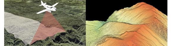
Geographic and property information
Figure 3: Aerial capture of LiDAR resulting in a 3D point cloud visualisation
RELEASED
OFFICIAL
The benefits of LiDAR over other techniques include:
• higher resolution
• accuracy to within centimetres
• large coverage areas
• ground detection in densely vegetated terrain.
To date, LINZ has published high-resolution 3D mapping data for Northland, Auckland,
INFORMATION
Waikato, Bay of Plenty, Taranaki, Hawke’s Bay, Gisborne, Wellington, Marlborough,
Tasman, West Coast, Canterbury, Otago and Southland.
UNDER
Current LiDAR data coverage across the country sits at over 50 percent. This is set to
increase to over 80 percent by the time work concludes in 2024.
1
This 3D data can be used for:
• property and land development
• understanding and managing the impacts of natural hazards and climate change
• improving environmental management, including water resource planning
THE
• forestry management and habitat protection
• providing farm-scale information to benefit the agriculture and forestry sectors.
In response to the North Island weather events in early 2023, LINZ is working with local
and central government agencies to procure and publish aerial imagery and LiDAR data to
support recovery activities in affected regions. This data will be collected and published
ACT
over the next two years.
In late 2023, LINZ will update you on the LiDAR funding it received in Budget 2023 as
part of the response to the North Island weather events.
1 There are some areas of New Zealand where accurate elevation data is not required (such as Fiordland). In
addition, the programme was a time-limited co-funding collaboration with councils, and some chose not to
participate at the time.
10
Geographic and property information
3.1.3 Mapping New Zealand’s coastline in 3D
Budget 2023 provided funding for LINZ to produce detailed coastal maps for climate
change adaptation. This information would help identify coastal areas that are at
significant risk of flooding, tsunami, or inundation.
If this project proceeds as planned, LINZ will use the data to create high-definition 3D
RELEASED
OFFICIAL
models and images of 85 percent of New Zealand’s coastline.
3.1.4 Hydrographic data for nautical charts
The New Zealand Hydrographic Authority is based within LINZ. The hydrographic data
LINZ collects is used to produce the official nautical charts to aid safe navigation in New
Zealand waters, parts of Antarctica, and parts of the south-west Pacific. New Zealand is the
primary charting authority for the Cook Islands, Niue, Tokelau, Tonga and Samoa.
3.1.5 Connecting central and local government
INFORMATION
property data
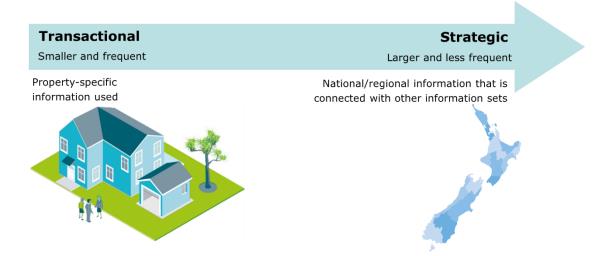
Property information includes property boundaries, ownership, ratings, addresses,
UNDER
buildings and utilities. Property decisions are made every day and vary from transactional
to strategic.
Figure 4: Transactional and strategic property decisions
THE
ACT
The property rights regime plays an essential role in creating the property information
(boundary and ownership data) released through the LINZ Data Service. The property
rights supplementary briefing provides more detail.
As well as maintaining boundary and ownership data, LINZ maintains a national
addressing dataset. This is published on the LINZ Data Service. LINZ has also created a
national dataset of the district valuation roll, which is collated from individual councils.
11
Geographic and property information
3.1.6 Publishing data on the LINZ Data Service
The LINZ Data Service provides free online access to New Zealand’s most up-to-date land
and seabed data. It has over 100,000 registered users who can access data related to:
• aerial imagery
• land title data
RELEASED
OFFICIAL
• elevation data
• place names
• topographic data
• street addresses
• property boundaries
• road information.
Users can search, browse and download data, and can integrate LINZ data into their own
applications. Most users are from engineering, surveying, geospatial/mapping,
agriculture, or central and local government organisations. The Data Service has around
3,500 visitors per day – this has almost doubled since a new interface was released with
very positive customer feedback.
INFORMATION
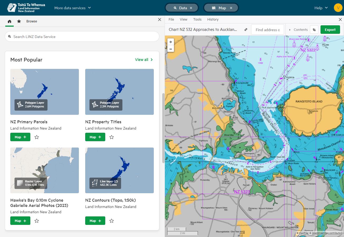
Figure 5: Waitematā Harbour maritime chart accessed thorugh the LINZ Data Service
UNDER
THE
ACT
12
Geographic and property information
3.2 Maintaining New Zealand’s positioning
infrastructure
LINZ is responsible for maintaining New Zealand’s positioning infrastructure. This
provides the spatial reference framework needed to create maps and nautical charts, and
to determine property boundaries. It also links New Zealand into the global positioning
RELEASED
OFFICIAL
reference frame.
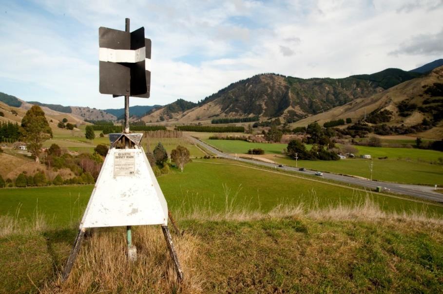
The positioning infrastructure includes:
• reference stations that collect satellite positioning data, and provide control points
to ensure survey marks are accurate and account for tectonic plate movement
• survey marks, including trig stations, which support property and infrastructure
development by helping determine property boundaries
• the Warkworth Radio Astronomical Observatory, which provides space-based
measurements that are critical to the global positioning reference frame
INFORMATION
• SouthPAN infrastructure and its data. UNDER
Figure 6: A trig station
THE
ACT
3.3 SouthPAN project to improve positioning data
LINZ and Geoscience Australia are working together to deliver SouthPAN and improve
positioning data.
SouthPAN is a satellite-based augmentation system (SBAS) made up of reference stations,
telecommunications infrastructure, computing centres, uplink centres and satellites.
Similar systems operate in North America, Europe, Japan, China and India. Other
13
Geographic and property information
countries, including the United Kingdom and South Korea, are also actively investing in
SBAS technology.
3.3.1 SouthPAN will deliver economic benefits
The improved accuracy of positioning information provided by SouthPAN will support
innovation across transport, agriculture, construction, forestry and horticulture. The
RELEASED
OFFICIAL
quantified economic benefits across multiple sectors are estimated to be $864m over the
next 20 years. This figure will grow as new technologies and innovations are developed to
harness SouthPAN’s possibilities.
SouthPAN signals will be available ‘free-to-air’ meaning they will be publicly available for
a broad range of potential uses. Early SouthPAN signals are being delivered now, so
benefits can be delivered from early in the project.
Stakeholders have been positive about the project and have identified critical benefits for
their industries.
UNDER
INFORMATION
THE
ACT
14
Geographic and property information
Figure 7: Stakeholder views of critical benefits of SouthPAN
Primary production
• "As a leading research and development organisation in this sector, we recognize the
transformational potential of SouthPAN and its capabilities, which are closely aligned with
our mission to advance the forestry sector. We are confident that its implementation will
RELEASED
OFFICIAL
lead to more informed, efficient, and sustainable forestry practices." - Scion
• SouthPAN will improve productivity and efficiency in the primary production sector.
Virtual fencing allows precise monitoring and control of livestock, helping farmers
optimise pastoral use. Sprays and fertilisers will be used more efficiently, especially when
delivered by aerial units.
Aviation
• Aviation safety and operations will be significantly improved when aircraft (including air
ambulance and air rescue services) are able to fly in adverse weather conditions, such as
low cloud.
INFORMATION
• "SouthPAN will benefit aviation by enabling improved instrument flight procedures to
be developed allowing a wider range of aircraft to complete flights to more locations
UNDER
throughout NZ safely in poor weather conditions such as low cloud. This will be of
particular benefit for air ambulance and air rescue services into regional and remote
locations." - Airways International
Data-driven decision making
• "SouthPAN presents an invaluable opportunity with its potential to enhance our ability
to make better data-driven decisions and improve the overall management of offenders
in our care. We are collaborating with LINZ and our technology partner to explore the
THE
possibility of integration of SouthPAN with a future generation of monitoring devices." -
Department of Corrections
Environment
• More accurate and reliable positioning services will help support New Zealand’s
ACT
environmental targets. For example, real-time, precise positioning data will help in pest
control and soil management.
• "The deployment of SouthPAN will enable us to significantly improve the spatial
accuracy with which we record spatial data and validate complementary data sets.
SouthPAN therefore has considerable application and benefits to our collective efforts
and DOC intends to fully explore the use and integration of SouthPAN into our
conservation toolkit." - Department of Conservation
15
Geographic and property information
3.3.2 New Zealand and Australia share decision-making
New Zealand and Australia have equal decision-making rights in relation to the delivery
of SouthPAN. SouthPAN is primarily governed by a New Zealand-Australia Joint
Governance Board. New Zealand provides 25 percent of the funding and Australia 75
percent.
RELEASED
OFFICIAL
The Governance Board is responsible for overseeing project delivery, finances and risk
management. Members include LINZ and Geoscience Australia, as well as independent
members nominated by each agency.
Geoscience Australia is the procurement lead for SouthPAN contracted services.
Procurement activities must comply with Commonwealth Procurement Rules, and be in
alignment with New Zealand Government Procurement Rules.
Significant contracts that have been awarded to date include the ‘prime’ contract with
Lockheed Martin Australia to build and operate the SouthPAN service for 19 years, and
the contract with Inmarsat Navigation Ventures Ltd to provide satellite capability through
INFORMATION
new and existing satellite infrastructure.
Decisions on significant contracts are made jointly by the Chief Executives of each agency,
UNDER
on the recommendation of the Joint Governance Board.
Ministers are regularly informed of progress on contract activity (including decisions
on contracts), and approval has previously been given by Ministers for the
SouthPAN Implementation Business Case and award of the ‘prime’ contract.
3.3.3 SouthPAN is on track for delivery
THE
As part of implementing SouthPAN, two new satellite payloads will be launched. The first
was procured in May 2023, and a tender for the second is being led by Geoscience
Australia. The tender offer period for the second satellite payload closes in January 2024.
Since committing to the delivery of SouthPAN in 2022, several milestones have been
achieved:
ACT
• In September 2022, contracts were entered into and the formal delivery of
SouthPAN commenced. This included an agreement between LINZ and
Geoscience Australia for the supply of a satellite-based augmentation system, and
Geoscience Australia entering into a contract with Lockheed Martin Australia for
the provision of the SouthPAN service for 19 years.
• In March 2023, construction started on New Zealand’s SouthPAN satellite uplink
centre in Awarua, near Invercargill. Two 11-metre antennas are being built at the
site. They will link to a control centre in Invercargill, monitored 24 hours a day.
16
Geographic and property information
• In May 2023, a new satellite service for SouthPAN was confirmed, with services to
be broadcast for 15 years from a new Inmarsat I-8 satellite from 2027. The new
SouthPAN satellite service on the Inmarsat I-8 satellite will replace the Inmarsat I
4F1 satellite, which was acquired as part of the SouthPAN test-bed trial.
Alongside the additional satellite capability, the SouthPAN network will be made up of
RELEASED
OFFICIAL
more than 30 ground reference stations across New Zealand, Australia and further ashore
including in Antarctica.
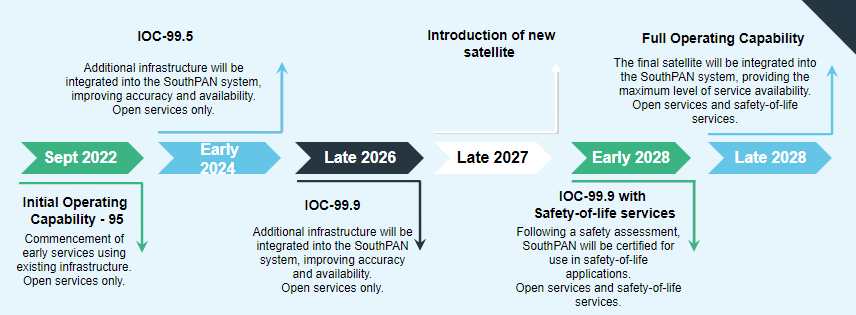
3.3.4 A five year establishment phase for SouthPAN is
underway
Full operating capacity for SouthPAN is expected in the 2028/29 financial year, which will
then be followed by a 14-year period of operations. The current life of the project is 19
years through to 2042. LINZ is in the five-year establishment phase to build the network,
which will see capability of the network increased over this period.
INFORMATION
Figure 8: SouthPAN's delivery timeline
UNDER
THE
Some of SouthPAN’s benefits can be delivered in the early stages of the project. For
example, early open services have been available since September 2022. Further
certification is needed, however, before the aviation sector can rely on SouthPAN signals
ACT
for safety-of-life applications.
17
Geographic and property information
Figure 9: Major milestones in SouthPAN's delivery
Date
Activity
April 2024
Construction completed at the Awarua uplink centre
June 2024
Uplink centre operations commence
OFFICIAL
Late 2024
Second satellite payload procured, and contract entered into
RELEASED
Late 2025 – early
Ground reference station sites come online
2026
March 2026
Uplink centre in Awarua fully contributes to the service
Late 2027
First satellite payload comes online
Mid 2028
Safety-of-life operations begin (initially with limited continuity)
Late 2028
Second satellite payload comes online, full operational capability
is achieved and continuity is assured for safety-of-life operations
INFORMATION
UNDER
In early 2024, LINZ will update you on the procurement of the second satellite
payload.
3.4 Administering Ngā Pou Taunaha o Aotearoa New
Zealand Geographic Board
LINZ supports the NZGB, the national place naming authority for New Zealand, its
THE
offshore islands, undersea regions on the continental shelf, and the Ross Sea region of
Antarctica.
The NZGB’s purpose, functions and duties are described in the New Zealand Geographic
Board (Ngā Pou Taunaha o Aotearoa) Act 2008. Its fundamental roles are to:
ACT
• give places and geographic features official names
• approve existing recorded place names that are unofficial
• change existing place names (for example, by correcting their spelling)
• alter district and region names of territorial authorities
• provide advice on place names that are part of cultural redress in Treaty of
Waitangi claim settlements
• review names of Crown reserves managed by the Department of Conservation
• maintain the New Zealand Gazetteer (an online searchable tool with over 54,000
place names) which lists all place names.
18

Geographic and property information
Road names and the name of New Zealand are outside of the NZGB's jurisdiction.
Place names are integral to contextualising location and address, and supporting
navigation. Place names also contribute to individual and national identity. Making place
names official is important as it means there is one agreed and correct name for a place.
One of the NZGB’s statutory functions is to encourage the use of original Māori names on
OFFICIAL
official charts and official maps (section 11(e), New Zealand Geographic Board (Ngā Pou
RELEASED
Taunaha o Aotearoa) Act 2008). Proposals for place names are predominantly Māori and
submissions are increasingly in support of these proposals.
Place name proposals can result in strong views and the NZGB takes account of
community views through public consultation. In these cases, final decisions may be
referred to you. You may wish to meet with the Chair to discuss proposals and
submissions received before making a decision. You may also choose to make any
announcements to the media.
The NZGB has 10 board members (
Annex 2). Two board members are ex-officio from
LINZ and you appoint the remaining eight members. The Surveyor-General is the NZGB’s
INFORMATION
Chair. The NZGB is supported by a secretariat within LINZ who provides administrative
support, research, advice and project delivery. UNDER
Figure 10: Surveyor-General
•
Sets standards for the cadastral and geodetic survey
regimes, and monitors and audits compliance with those
standards.
•
Administers place naming as ex-officio Chairperson of
Ngā Pou Taunaha o Aotearoa New Zealand Geographic
THE
Board.
•
Supports the setting of electoral boundaries by the
Surveyor-General: Anselm Haanen
Electoral Commission.
3.5 Improving New Zealand’s preparation and
ACT
response to emergency events
New Zealand needs accessible and accurate geographic and property data to prepare for
and respond to emergencies and climate change events. LINZ coordinates and uses these
datasets to support organisations before and in the aftermath of emergency events, and
to help prepare for the impacts of climate change.
19
Geographic and property information
3.5.1 Providing data to assist emergency responses
LINZ works with central and local government agencies to ensure their emergency
management data needs are met, including coordinating the procurement of additional
data of affected areas.
Figure 11: LINZ data provision to agencies for emergency response
RELEASED
OFFICIAL
LINZ coordinates the procurement of key data
Satellite imagery
LiDAR elevation data
Aerial imagery
Hydrographic data (detailed sea-bed mapping)
Organisations that use LINZ data during an emergency event
National Emergency Management
Civil Defence emergency management groups
Agency
Emergency response agencies (Fire,
GNS Science, National Institute of Water and
Police, and NZ Defence Force)
Atmospheric Research
INFORMATION
Businesses involved in emergency
Voluntary groups and individuals involved in
responses
emergency responses
UNDER
NZTA, KiwiRail
Councils
A wide range of organisations use LINZ data to coordinate response activities, analyse
and record the scale of damage, and assess impacts such as the extent of a flood or the
loss of farmland after a fire.
The value of LINZ’s national datasets was demonstrated in the aftermath of Cyclone
Gabrielle. Address and population data helped ensure isolated communities were
THE
accounted for, and KiwiRail used imagery to assess damage to railway bridges and
supporting infrastructure. LINZ acquired high-resolution satellite and aerial imagery
showing the Hawke’s Bay, Gisborne and Tararua districts immediately after the cyclone
hit, and provided this to agencies to support their response.
LINZ can work with you on policies to improve government data procurement and
ACT
sharing.
3.5.2 Improving data for emergency response
LINZ has been leading the improvement of datasets that are critical to emergency
management decision-makers. This has been guided by customer insights from the Civil
Defence emergency management community.
These datasets play a role in decision making in the context of emergency management
including risk reduction, readiness, response and recovery.
20


Geographic and property information
Figure 12: Key datasets critical to emergency management decision-making
• Addresses
• Roads
• Suburbs and localities
• Rail
• Buildings
• Property
RELEASED
OFFICIAL • Population
• Aerial imagery
• Rivers and
•
catchments
Topographic maps
• Elevation
• Coastline
• Place names
INFORMATION
This continuing data improvement programme involves collaborating with data holders
such as KiwiRail, the Ministry for Business, Innovation and Employment, the National
UNDER
Institute of Water and Atmosphere, Stats NZ and NZTA.
LINZ can provide advice to you on further opportunities to use LINZ data in
emergency responses, and how to improve this.
3.6 Preparing for a transformation to fully digital
maritime navigation
THE
New Zealand is an active member of the International Hydrographic Organisation (IHO).
The IHO is responsible for ensuring all the world’s seas, oceans and navigable waters are
surveyed and charted to consistent standards.
The IHO has developed new global data standards which will transform international
maritime navigation, and LINZ is responsible for their implementation in New Zealand’s
ACT
areas of charting responsibilities.
Known as the S-100 Universal Data Model, the standards will support autonomous
shipping, improve safety at sea, reduce emissions and increase supply chain efficiencies.
Mariners will be able to send and receive information about the physical environment,
such as tides, weather and hazards such as ice. They will also be able to share information
about berthing and landside services, maximising the efficiency of ports, ships and
landside transport providers.
21
Geographic and property information
Using the new standards, LINZ is responsible for introducing new electronic navigation
charts as well as bathymetric and water level products from 2026. This transformation is
an international obligation that will require investment.
LINZ is engaging with Maritime New Zealand, the regulator for navigational safety in New
Zealand waters, to explore opportunities to work together on introducing the standards.
RELEASED
OFFICIAL
LINZ will update you on work to introduce the new international data standards.
LINZ is also available to discuss how the new digital standards for hydrography link
to several areas of government policy, including the freight and supply chain
strategy and emissions reduction policy. LINZ will provide advice on this as policy
develops in the transport and environment portfolios.
UNDER
INFORMATION
THE
ACT
22
Geographic and property information
4 LINZ’s activity in the property information
regime
4.1 Property information
RELEASED
OFFICIAL
Property information is the essential information about land parcels and ownership that
enables accurate land management, valuation, transacting and decision-making.
Property information is created by many local and central government agencies through
their regulatory regimes and operational processes. For example, the Building Act 2004
(administered by the Ministry of Business, Innovation and Employment) requires building
consent information to be created, and then councils provide this information to the
public.
LINZ also creates important property information through its regulatory responsibilities
and operational processes. This includes survey and title data created through the LINZ
INFORMATION
property rights regulatory regime. LINZ is also responsible for, or has responsibilities in,
other regulatory regimes that contribute to the creation of property data.
UNDER
4.2 Administering the valuation regime
You are responsible for administering the Rating Valuations Act 1998 and the Valuers Act
1948, the key legislation for the valuation regime.
Figure 13: Valuation regime
Rating Valuations Act 1998
Valuers Act 1948
THE
• This Act establishes the role of the Valuer-
• This Act sets the rules on who can undertake
General and the regulatory regime
property valuations in New Zealand.
determining valuations for rating
• It creates bodies and regulatory power to
purposes.
determine which professional bodies will
• It creates timeframes and obligations to
manage professional obligations and set rules
ACT
ensure the rating regime has sound basis
for valuers.
in valuation.
• It sets up an objection process so that
people can dispute their valuations.
Local authorities undertake valuations of the properties in their area and use this
information to set rates. The Valuer-General at LINZ is responsible for regulating the
rating valuations industry under the Rating Valuations Act 1998. LINZ administers the
23

Geographic and property information
overall rating valuations regime to ensure it is credible and enables territorial authorities
to set rates fairly.
Valuation services must be undertaken by a registered valuer or an approved person or
body and must comply with rules under the Rating Valuations Act 1998. Valuations occur
at least every three years and are recorded in the district valuation roll, which feeds into
the property information regime.
RELEASED
OFFICIAL
The Rating Valuations Act 1998 also sets a requirement for territorial authorities to
comply with rules set by the Valuer-General.
4.2.1 The Valuer-General
The Valuer-General regulates the rating valuation regime and provides technical advice to
the government on valuation issues.
Figure 14: The Valuer-General is responsible for the rating valuation regime
•
The statutory officer responsible for regulating the rating
INFORMATION
valuation regime.
•
Plays a key role in the property information regime by
providing technical advice to the government on
UNDER
valuation issues, setting standards for the district
valuation role, and ensuring those standards are met.
•
May make rules setting requirements in relation to
valuations and district valuation rolls and require
Valuer-General Neill Sullivan
information to be provided to the Valuer-General or to
any other person.
•
Audits rating valuations carried out or commissioned by
local authorities to ensure they comply with the rules and
must give their approval before a general revaluation can
THE
be implemented.
•
Administers the Valuers Registration Board, which is
responsible for occupational regulation of registered
valuers and issues practising certificates.
The rating valuation regime is critical for local government functions. New Zealand’s
ACT
territorial authorities rely on rates to generate over $5.8 billion, approximately 59 percent
of their total operating income. Correct rating valuations are essential for territorial
authorities to implement their rating policies.
Accurate rating valuations and supporting property data are also used for lending,
insurance and private purchase purposes.
24
Geographic and property information
4.2.2 [ s 9(2)(g)(i) ], [ s 9(2)(f)(iv) ]
[ s 9(2)(g)(i) ], [ s 9(2)(f)(iv) ]
RELEASED UNDER THE
OFFICIAL
INFORMATION
[ s 9(2)(g)(i) ], [ s 9(2)(f)(iv) ]
ACT
25

Geographic and property information
Figure 15:
[ s 9(2)(g)(i) ]
[ s 9(2)(g)(i) ],
[ s 9(2)(f)(iv) ]
RELEASED
OFFICIAL
[ s 9(2)(g)(i) ], [ s 9(2)(f)(iv) ]
[ s 9(2)(g)(i) ], [ s
IN
9(2)(f)(iv) ]
[ s 9(2)(g)(i) ], [ s 9(2)(f)(iv) ]
E
4.2.4
[ s 9(2)(g)(i) ], [ s 9(2)(f)(iv) ]
T
[ s 9(2)(g)(i) ], [ s 9(2)(f)(iv) ]
26
Geographic and property information
5 Outlook for geographic and property
information
Currently, a range of geographic and property information is produced and collected by
many national and local government agencies but no one agency is the contact for or
RELEASED
OFFICIAL
coordinator of geospatial data. This was an issue after Cyclone Gabrielle as local councils
and agencies sought to find the information they needed for the response effort. LINZ
stepped into this leadership space, coordinating across government and providing
imagery that, combined with data provided by councils, was used by response and
recovery personnel to help them undertake effective action.
The Government Chief Data Steward (the Chief Executive of Stats NZ) is the functional
leader for data, setting the strategic direction, leading the response to emerging data
issues and facilitating a joined-up approach to data across government. The Government
Chief Data Steward supports delegating responsibility for geospatial data leadership to
the Chief Executive of LINZ, providing the sector with a dedicated coordination point for
INFORMATION
government geospatial data. LINZ will discuss further with you the ways in which this role
could be performed and opportunities it will bring for wider public and private use of our
UNDER
data.
THE
ACT
27
Geographic and property information
6 Next steps
LINZ is ready to respond to your direction on priorities for the geographic and property
information regime as part of your Land Information portfolio responsibilities. LINZ can
develop advice and options for issues of importance to you. LINZ will also provide advice
on implications for the geographic and property information regime as wider government
RELEASED
OFFICIAL
priorities are identified.
UNDER
INFORMATION
THE
ACT
28
Geographic and property information
Annex 1 Critical relationships
The critical relationships in the geographic and property information regime are
with other Ministers, the public, Māori, geospatial and property professionals and
businesses, and central and local government.
RELEASED
OFFICIAL
Other Ministers
Minister of Finance,
• The Minister of Finance and Minister of Transport are key
Minister of Transport
stakeholders in SouthPAN due to its significant transport sector
benefits.
Other Ministers
• You are likely to work closely on policy development with a
range of Ministers including the Minister for the Environment
and the Minister of Conservation.
Australian Minister for
• You and Hon Madeleine King, the Australian Minister for
SouthPAN
Resources and Minister for Northern Australia, are jointly
responsible for the delivery of SouthPAN.
INFORMATION
Māori
UNDER
Māori
• Māori are a key stakeholder in place names and correct spelling,
due to their tangata whenua status over the land. The NZGB has
a function to collect and encourage the use of original Māori
place names on official maps and charts.
New Zealanders and New Zealand businesses
Individuals, businesses,
• Individuals, businesses and communities use geographic and
communities
property information data as part of day-to-day economic and
social decision making. You can expect to receive THE
correspondence from many of these individuals and businesses.
You may also be invited to meet with industry organisations.
Officials can provide advice and information to assist you in any
meetings.
Central and local government
ACT
Ministry for the
• LINZ works with the Ministry for the Environment on
Environment and
environmental data and climate change. The agencies have
Department of
shared priorities for the cross-agency Climate Change and
Conservation
Sustainability Chief Executives agenda. LINZ works with DOC on
biodiversity monitoring and land management.
Emergency Management • LINZ provides information to the sector (including the National
Sector
Emergency Management Agency, Police, Defence, Fire and
Emergency NZ and the Earthquake Commission) to support
emergencies and build resilience. This includes the location,
terrain and conditions of hazardous areas.
29
Geographic and property information
Other government
• LINZ partners with Te Arawhiti – Office for Māori Crown
agencies
Relations on engaging with Māori and ensuring the fulfilment of
Treaty commitments relating to place names.
• LINZ works with Stats NZ and the Government Chief Data
Steward to ensure the supply of geographic and property
information to New Zealand’s wider data ecosystem.
OFFICIAL
Local government
•
RELEASED
LINZ works with local government for the provision of
geographic and property information. It also connects property
information and environmental data sets and managing the
Crown estate, especially around rivers and lakebeds.
• LINZ provides data and knowledge to support local
government’s decision making and management of
infrastructure, water, pests, damaged land and visitors.
Statutory officers and boards
Valuer-General, Neill
• The Valuer-General is responsible for regulating the rating
Sullivan
valuation regime. The Valuer-General plays a key role in the
property information regime by providing technical advice to the
INFORMATION
government on valuation issues, setting standards for the district
valuation role, and ensuring those standards are met. The Valuer-
UNDER
General is the ex-officio Chair of the Valuers Registration Board.
Surveyor-General,
• The Surveyor-General is responsible for setting the standards for
Anselm Haanen
the cadastral and geodetic regimes, and monitoring and auditing
compliance with those standards. The Surveyor-General also
administers the naming of places and supports the Electoral
Commission’s setting of electoral boundaries. The Surveyor-
General is the ex-officio Chair of the NZGB, and an ex-officio
member of the Cadastral Surveyors Licensing Board.
THE
Valuers Registration
• The Valuers Registration Board is responsible for the
Board
occupational regulation of registered valuers and issuing
practicing certificates. You are responsible for appointing the
members of the Board.
Cadastral Surveyors
• The primary function of the Cadastral Surveyors Licensing Board
Licensing Board
is the licensing of cadastral surveyors competent to conduct
ACT
cadastral surveys. You are responsible for appointing the
members of the Board.
Ngā Pou Taunaha o
• The role of the NZGB is to give places and features official
Aotearoa New Zealand
names, approve place names that are unofficial, change place
Geographic Board
names, for example by correcting spelling, and review Crown
reserve names. The Board maintains the
New Zealand Gazetteer and provides advice on place names that are part of cultural
redress in Treaty of Waitangi claim settlements. You are
responsible for appointing the members of the Board.
30
Geographic and property information
Annex 2 Board membership
Name
Date of original appointment
Expiry date of present term
New Zealand Geographic Board
HAANEN, Anselm (Chairperson)
2018
Ex Officio
GREENLAND, Adam
2011
Ex Officio
RELEASED
OFFICIAL
BARNETT, Shaun Christopher
2020
24 Feb 2025
KAUMOANA, Cadence
2023
10 Jul 2026
TOKA, Emmanuel Mahana
2023
10 Jul 2026
KEARNS, Professor Robin Affric
2023
10 Jul 2026
KAWHARU, Professor Merata
2013
24 Feb 2025
VERNON, Jennifer Anne
2010
24 Feb 2025
ELLIFFE, Paulette Joan
2016
24 Feb 2025
CRANWELL, Iaean
2023
10 Jul 2026
Valuers Registration Board
INFORMATION
SULLIVAN, Neill Anthony (Chairperson)
2004
Ex Officio
UNDER
GAMBY, Michael Evan Leigh
1991
22 Dec 2025
(Deputy Chairperson)
CURNOW, Phillip Allen
2007
12 Aug 2023
MURDOCH, Victoria Louise
2016
22 Dec 2025
TAYLOR, Kenneth Ross
2007
12 Aug 2023
Cadastral Surveyors Licensing Board
FAULKNER, Neale Charles Thomas
2010
12 Oct 2026
(Chairperson)
HAANEN, Anselm
2018
Ex Officio
THE
COLL MCLAUGHLIN, Laura Becker
2023
12 Oct 2026
DAGGUBATI, Sundeep Chowdary
2023
12 Oct 2026
JIANG, Pengbo
2023
12 Oct 2026
MCELWAIN, Colin Robert
2019
12 Oct 2026
MCINNES, Craig Kenneth
2016
12 Oct 2026
ACT
TOLAN, Clare Elizabeth
2023
12 Oct 2026
Orton Bradley Park Board
FERGUSON, Francis David (Chairperson)
2
2022
11 Oct 2025
2 Under the R O Bradley Estate Act 1972 the Chairman of the Orton Bradley Park Board is appointed by the Governor
General on the advice of the Minister for Land Information.
31