Imagery Elevation Bathymetry
RELEASED UNDER THE
OFFICIAL
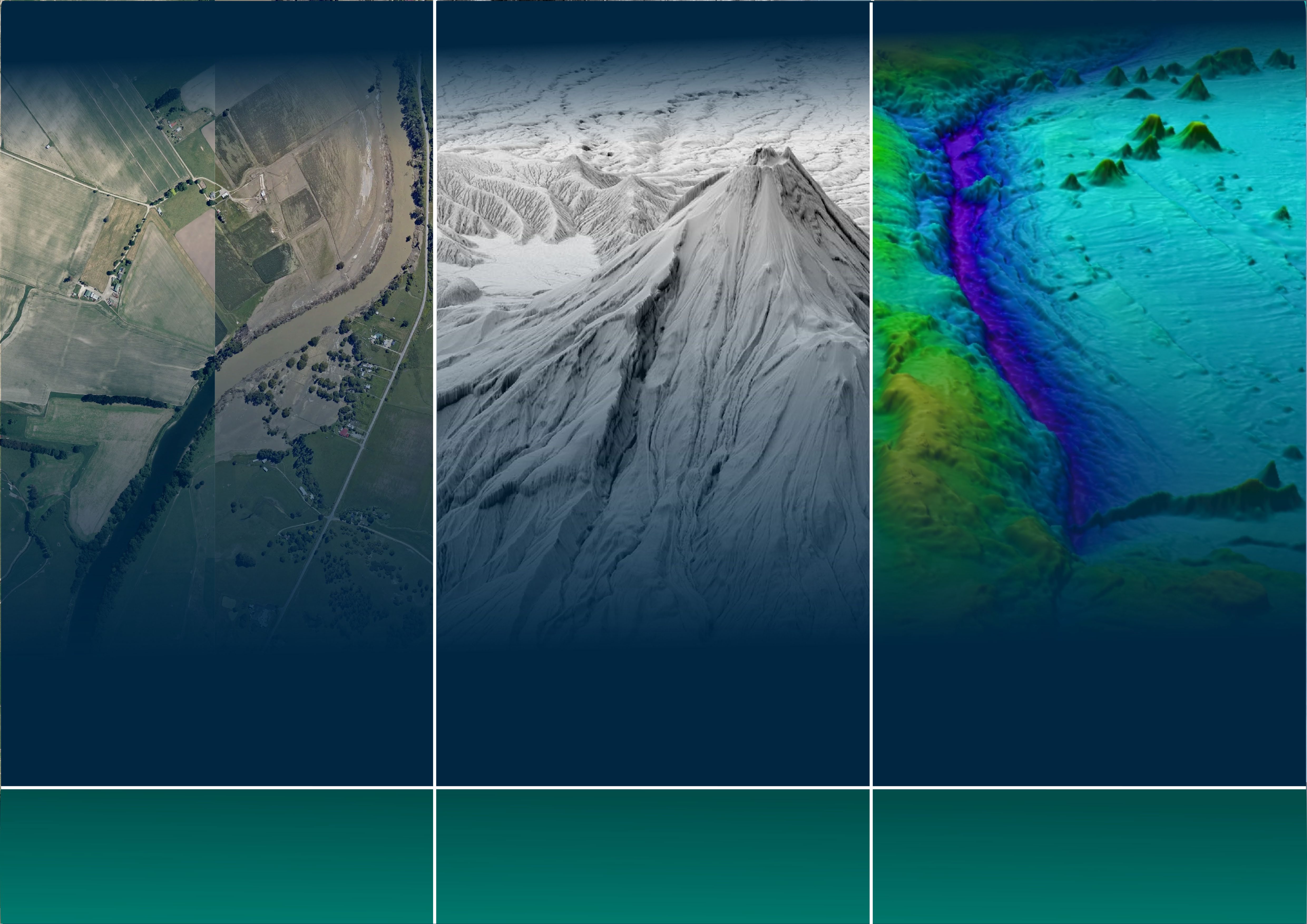
INFORMATION Aerial and satellite imagery provides accurate 3D elevation data details the height and shape of the Reliable up-to-date nautical charts and information photographic representation of the earth’s surface land and the things on it, for example buildings and is essential for safe navigation; to keep people safe and the features on it. The imagery can be used to vegetation. The technology used is called light and the environment protected. visualise the landscape or understand how an area detection and ranging or ‘LiDAR’, mounted on has evolved. aircraft. LINZ collects seafloor data (bathymetry) to produce official nautical charts for New Zealand waters, parts LINZ publishes aerial imagery covering 95% of the LINZ is on track to have LiDAR data available for 80% of Antarctica, and areas of the south-west country which is freely available for others to use. It of the country by 2024. LiDAR data is valuable to Pacific. LINZ’s nautical charts are used by can be accessed through the LINZ Data Service, AWS both public and private sector organisations for: commercial and recreational mariners. open data registry, or the LINZ Basemaps service which lets users build their own maps on top of LINZ
• Improving environmental management Bathymetry has other applications such as scientific published imagery. including water resource planning, forestry research and tide predictions. management and habitat protection In response to the North Island weather events in
• Providing farm-scale land information to In 2022/23 we were allocated $39.2 million over four early 2023, LINZ is working with local and central benefit the agriculture and forestry sectors years to undertake 3D coastal mapping. government agencies to procure and publish aerial
• property and land development, engineering This investment will support coastal communities,
ACT imagery and LiDAR data to support recovery and communications infrastructure, iwi, businesses and local and central government activities in affected regions. archaeology, architecture, and design to prepare for the impacts of climate change and applications. understand how the coastline is changing. We coordinate with councils, regional consortiums and response LiDAR elevation data capture project is providing co-funding to Due to the lead-in time needed for hydrographic surveys, we plan agencies to acquire and publish aerial imagery of New Zealand. develop a consistent elevation dataset across a number of regions. several years ahead. The capture from airborne sensors and cameras that give us an The standard open-data products are a 1m gridded bare earth The priority regions take into account ship traffic, hazards and accurate photographic representation of the earth’s surface and digital elevation model, a 1m gridded digital surface model, and the age of existing navigational information to determine the the features on it. the source data point cloud. level and location of navigational related risk. Property Address Buildings
RELEASED
OFFICIAL
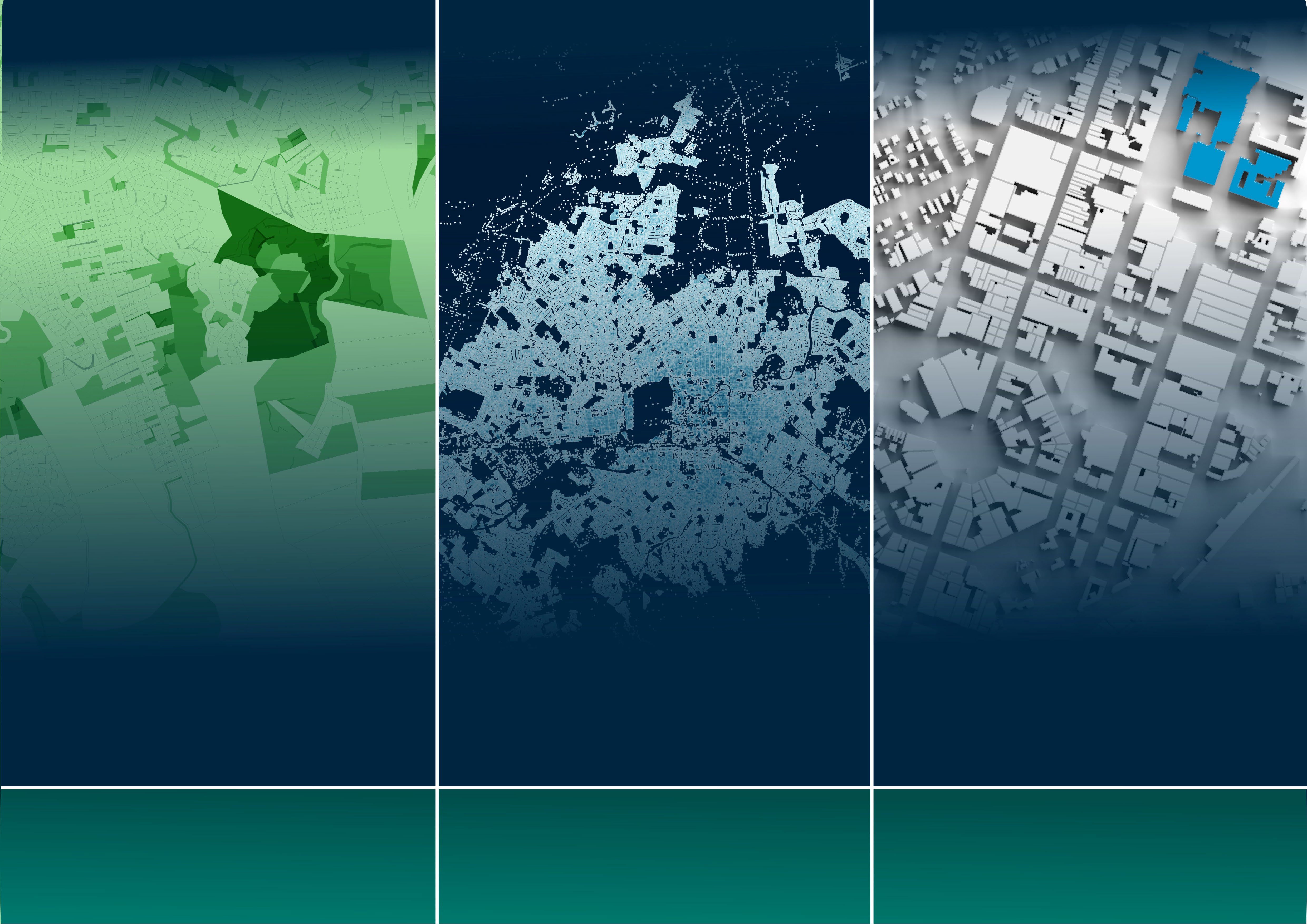
INFORMATION It is critical that decisions about property and land Property addresses and suburb information are Building outlines is a key dataset to support both
UNDER are well informed because these decisions impact needed for mail, emergency services like fire, police, urban planning and community resilience. It also quality of life and the environment. and ambulance, as wel as utilities like power and provides context when trying to understand land water. Addresses are also the basis of New Zealand’s use, changes over time and places of interest. Property information is the essential information voting system. about land parcels and ownership that enables This building outline dataset provides a accurate land management, valuation, transacting, LINZ maintains the official national record of all road foundation for various stakeholders to map risk and decision-making. names and property numbers in New Zealand. modelling, environmental assessment, LINZ assesses all numbering and naming proposals urban development, resilience planning in addition LINZ creates important property information from councils against the national standards to the visualization and physical location of
THE through its regulatory and responsibilities and before adding them to the official record. buildings. operational processes; its datasets include property boundaries, ownership, and rating information. LINZ's address and suburb data is key information used for decision-making during emergency Uses include: events. In the aftermath of Cyclone Gabrielle, emergency management groups used LINZ's address
ACT
• Waka Kotahi and councils deciding where to data with StatsNZ's population data to help ensure invest in roading infrastructure isolated communities were accounted for.
• Property developers and local government deciding where to build housing developments LINZ has a leadership role in connecting property When new addresses are created by local councils, LINZ contracts a New Zealand expert on machine data from central and local government. This they provide those to LINZ. They are assessed learning to produce buildings data from the latest includes creating a national dataset of district against the national addressing standard and aerial imagery. After automated checks and manual valuation roll (DVR) collated from individual councils, approved into the National Addressing Database. quality assurance. and making it available to local and central government