

QUEEN STREET
ESSENTIAL VEHICLES AREA EVALUATION
Sienna MacArthur-Beadle | Rebecca Luther | Hamish Mackie
4 OCTOBER 2022
MACKIE RESEARCH QUEEN STREET: ESSENTIAL VEHICLES AREA EVALUATION
1


Document Title:
Queen Street: Essential Vehicles Area Evaluation
Prepared for:
Auckland Transport
Prepared by:
Sienna MacArthur-Beadle and Rebecca Luther
Internal peer review: Hamish Mackie
Signed
Date: 04/10/2022
Revision history
Revision
Amendments
Completed by
Date
No.
1
Correction of background information
Sienna MacArthur-
06/10/2022
(infringements) and alteration to
Beadle
recommendation 4.
Mackie Research is an organisation providing high quality independent human systems research and consultancy
services. Mackie Research has expertise across a range of areas including transport human factors (road safety and
sustainable transport), recreation, equipment design, evaluation and other areas where interactions between
people and their environment or the things that people use are important.
Authorship: This document was written by Sienna MacArthur-Beadle, Rebecca Luther, and Hamish Mackie. For
further information, please contact Hamish using the contact details below.
Disclaimer: Mackie Research, its contributors and employees shall not be liable for any loss or damage sustained
by any person relying on this report, whatever the cause of such loss or damage.
Mackie Research:
Physical address
Postal address
Level 2
PO Box 106525
1 Albert Street
Auckland City
Auckland 1010
Auckland 1143
www.mackieresearch.co.nz
MACKIE RESEARCH QUEEN STREET: ESSENTIAL VEHICLES AREA EVALUATION
2
CONTENTS
1.
BACKGROUND ................................................................................................................... 4
2.
SCOPE & METHOD ............................................................................................................. 6
2.1 Scope .......................................................................................................................................................... 6
2.2 Method ...................................................................................................................................................... 6
3.
EVALUATION FINDINGS ..................................................................................................... 9
3.1 Description of Queen Street EVA ............................................................................................................. 9
3.2 Wakefield Road EVA Approach ............................................................................................................... 13
3.3 Queen Street (travelling north) EVA Approach ..................................................................................... 15
3.4 Queen Street (travelling south) EVA Approach ..................................................................................... 17
3.5 Wellesley Street West EVA Approach .................................................................................................... 19
3.6 Cross EVA Findings .................................................................................................................................. 21
4.
RECOMMENDATIONS FOR EVA ........................................................................................ 22
Appendix A. driver behaviour observations .............................................................................. 26
MACKIE RESEARCH QUEEN STREET: ESSENTIAL VEHICLES AREA EVALUATION
3
link to page 4 link to page 5
1. BACKGROUND
In July 2022, Auckland Transport and Auckland Council introduced an Essential Vehicle Area
(EVA) on Queen Street between Wakefield Street and Wellesley Street. The EVA has been
established as part of operationalising the Auckland City Centre Master Plan which seeks to shift
the city centre from a place people 'go through' to a place that people 'go to'.
The EVA means that the section of Queen Street between the Civic Theatre on Wellesley Street
and the Town Hall at the intersection of Wakefield Street is closed to private vehicles, taxis, and
car share and rideshare services. The EVA can only be used by buses, bikes, mopeds,
motorbikes, emergency vehicles, and registered goods vehicles, vans, trucks, or utility vehicles.
The EVA applies 24 hours a day, 7 days a week, with breaches liable for a $150 infringement fee.
From 12 September 2022 Auckland Transport started issuing fines, but only to those who had
already received a warning notice. Warning notices are issued to anyone who drives through
the area for the first time. Auckland Transport allows two weeks for the warning to be mailed
out and received. If the same vehicle then drives through the area after this two-week period,
they receive a fine.
The EVA became operational on 3 July 2022. Road layout and signage changes, including
advanced warning signs, have been completed as well as public communications through
relevant websites, posters in carparks, and direct communications to taxi and rideshare
organisations. Some guidance on alternate routes if travelling by car through Queen Street has
been provided. However, a more coordinated set of changes to better direct traffic away from
Queen Street and around the city centre as envisaged by the A4E (Access for Everyone) strategy
will be undertaken at later date.
Since the EVA has gone live there has been a high degree of non-compliance with the vehicle
restrictions. Between the ‘go live’ date and approximately mid-September 2022, 51,000
infringements were recorded1.
Auckland Transport data does suggest that the number of violations is reducing over time (see
Table 1). However, the number of first-time offenders after the infringement process began
(see
Table 2) is still notable.
Table 1: EVA zone non-compliance statistics (source: Queen St TDM working group 20/9/22)
Week
Number of Observations
Total Warning
Letters
2
13,102
9,447
4
13,162
10,302
9
7,599
Stand down
10
2,476
Stand down
1 https://www.driven.co.nz/news/auckland-transport-starts-issuing-150-tickets-on-section-of-queen-st/
MACKIE RESEARCH QUEEN STREET: ESSENTIAL VEHICLES AREA EVALUATION
4
Table 2: EVA zone non-compliance statistics – live infringements (source: AT communication)
Week
Number of first-time
Number of repeat
Total number of
violations (receiving
violations (receiving
violations
warnings)
fines)
1
402
151
553
Feedback to Auckland Transport also suggests that the road design around the EVA has not
been consistently effective in alerting drivers not to enter the area. This could either be because
the signage is not visually salient enough, or because the information on the signs is confusing.
It is also possible that some drivers are unable to plan an alternate route ‘on the fly’ and
therefore feel they have no choice but to drive through the EVA.
Before beginning to issue infringement fines for all road users violating the EVA (rather than
issuing warnings for first time violators), Auckland Transport has commissioned a Human
Factors (HF) Review of the EVA. This will provide assurance that drivers are being given the best
possible opportunity to identify the EVA, understand what behaviours are required, and
respond appropriately.
This report details the results of the review. Each approach to the EVA is reported separately.
Recommendations are focused on enhancing the overall design of the EVA. Where
recommendations are particularly relevant to an approach this is highlighted.
It should be noted that various changes have been made to the layout of the EVA since
inception and further minor signage changes are planned. The review largely focused on the
current installation. However, the reinstatement of the Queen St Northbound ADS sign was also
considered.
MACKIE RESEARCH QUEEN STREET: ESSENTIAL VEHICLES AREA EVALUATION
5
link to page 7
2. SCOPE & METHOD
2.1
Scope
The HF review of the EVA involved three key steps:
• Developing a description of Queen Street EVA focused particularly on road design and
signage.
• Observations of drivers at each EVA approach where non-permitted vehicles are
present.
• Site evaluations of each EVA approach where non-permitted vehicles are present.
2.2
Method
Description of Queen Street EVA
EVA planning and design documents provided by Auckland Transport were reviewed to develop
a description of the EVA intervention. Communications materials and any route guidance was
also reviewed. A short description of the EVA is provided in the results section of this report.
Driver Behaviour Observations
Structured one-hour observations of the two approaches at the southern end of the EVA were
undertaken to gather data on driver behaviour
. Figure 1 shows where observers were stationed
at each approach. Due to roadworks at the northern end of the EVA, systematic observation
was not possible. Instead, multiple site visits informed general observations.
During structured observations the following information was recorded about passing vehicles
(except buses):
• Vehicle type (e.g., car/van/ute/truck)
• Vehicle use (e.g., private/commercial/rideshare/taxi – if information was available)
• Lead/following vehicle (was vehicle travelling through first or following others)
• Traffic lights on approach (red/orange/green)
• Behavioural observations (description of driver behaviour on approach to intersection,
during time at intersection and after travelling through, including manoeuvres such U-
turns, or pausing in a lane)
• EVA use (did the driver enter the EVA)
• EVA avoidance (did the driver make evasive manoeuvres to avoid the EVA)
Data for vehicles observed at southern approaches and general observations completed at
northern approaches are provided in Appendix A.
MACKIE RESEARCH QUEEN STREET: ESSENTIAL VEHICLES AREA EVALUATION
6
link to page 7 link to page 7

 Figure 1: Map of the Queen St EVA and the Observer Entry Points
Site Evaluations
Driving is a complex task. As drivers navigate the roadway, they gather and process sensory
information and compare it to their existing driving knowledge to make safe choices. Safe and
successful driving requires a well-designed road environment and a knowledgeable, alert driver.
A good overview of driving from a psychological perspective is provided by the model
in Figure
2 which was adapted from one developed by TNO Netherlands.
Figure 2: Model of Driver Behaviour (adapted from TNO)2
2 https://international.fhwa.dot.gov/humanfactors/chapter_seven.cfm
MACKIE RESEARCH QUEEN STREET: ESSENTIAL VEHICLES AREA EVALUATION
7
One of the main areas of interest for road safety human factors is identifying and mitigating
crash risks. Again, well established theoretical models provide a useful basis for identifying
these risks. Generally, adverse events and crashes happen when multiple system
factors/failures occur together (Reason, 19903).
James Reason’s Swiss Cheese model is a cornerstone of this understanding and shows how both
unsafe acts (e.g., being distracted, or travelling too fast for conditions) and pre-cursors to
unsafe acts (e.g., difficult road conditions, inexperience) can co-occur and result in crashes.
Human factors checklists provide a useful way of identifying risks/systems factors and
associated mitigations. For the purposes of this assessment, a road safety human factors
checklist was used that covered the following categories:
• General environment (context)
• Roadway design, signage, and markings
• Road users (demographic factors, behaviour, attitudes, mistakes/slips/violations)
• Environmental factors (weather, light levels etc.)
Under each category, human factors areas or issues that have been shown through research to
affect safety were considered (e.g., environmental complexity, road signage and marking
design, driver familiarity with the area). Areas where safety risks co-occurred was noted (e.g.,
visually complex background and small signage).
Assessments were made at each approach to the EVA where non-permitted vehicles were
present. These involved site visits, photos of the site from different positions, and previously
completed observations of driver behaviour. Two human factors specialists completed the
assessment at each site. A further peer review process was used to test whether all potential
issues had been identified.
Reason, J. (1990).
Human Error. Cambridge University Press.
MACKIE RESEARCH QUEEN STREET: ESSENTIAL VEHICLES AREA EVALUATION
8
link to page 9

3. EVALUATION FINDINGS
3.1
Description of Queen Street EVA
The extent of the Queen Street EVA (in yellow) is sh
own in Figure 3, as are the routes that non-
permitted vehicles can take to travel around the EVA without receiving an infringement fine.
The area within the EVA is closed to private vehicles, taxis, and car share and rideshare services.
Figure 3: Queen Street EVA (figure supplied by Auckland Transport)
MACKIE RESEARCH QUEEN STREET: ESSENTIAL VEHICLES AREA EVALUATION
9
link to page 10 link to page 10


Queen Street EVA Signage
Auckland Transport provided the team with EVA plans that included the signage provided in
Figure 4.
Figure 4: EVA signage provided by Auckland Transport (AT Traffic Signs and Roadmarkings Plan Sheet -2021-
PTM-16_G130
While it is not included in
Figure 4, an advance direction stack (ADS) sign was also installed
on Queen St between Karangahape Rd and Mayoral Drive. This sign, shown below, warns
the road user that “local access only” is permitted further down Queen St.
Figure 5: Advance direction stack sign installed between Karangahape Rd and Mayoral Drive (image
provided by AT)
MACKIE RESEARCH QUEEN STREET: ESSENTIAL VEHICLES AREA EVALUATION
10


During site observations temporary portable variable message signs (VMS) were also in
place for both northbound and southbound traffic on Queen St. The VMS message for
southbound road users is shown below.
Queen Street EVA Communications
The following images show examples of Queen Street EVA communications materials. In
addition to the materials identified, further signage and communications regarding the EVA are
still underway.
Figure 6: Queen Street EVA communications
MACKIE RESEARCH QUEEN STREET: ESSENTIAL VEHICLES AREA EVALUATION
11
link to page 12


Prior to Sunday 3rd July
Motorway VMS gantry signs also presented the following messages before and after July 3rd.
Prio
Pa r t
ge o S
1 unday 3rd July
Page 2
Page 1
Q UEEN ST CHANGE S
Page
16 2 QUEEN ST CHANGES
18
TOWN HALL-CIVIC
15
TOWN HALL-CIVIC
18
FROM SUN 3 JUL
15
NO GENERAL TRAFFIC
4
From 3rd July onwards
From Sunday 3rd July onwards Page 1
Page 1
QUEEN ST CHANGES
16
TOWN HALL-CIVIC
15
NO GENERAL TRAFFIC
15
Figure 7: Queen Street EVA motorway VMS gantry signs
The Auckland Transport Betterway website was also updated to include a page dedicated to
driving.4 The EVA is explained, and supplementary information (e.g., parking, pick-up, and drop-
off information) is provided.
Taxi companies and rideshare platforms were informed of the changes and were provided with
a circulation map
(Figure 8) showing various routes to access the areas of Queen St adjacent to
the EVA.
Figure 8: Taxi and rideshare Queen Street EVA communications
4 Driving (at.govt.nz)
MACKIE RESEARCH QUEEN STREET: ESSENTIAL VEHICLES AREA EVALUATION
12


3.2
Wakefield Street EVA Approach
Figure 9: Wakefield St EVA approach
Site Assessment
The general environment at the Wakefield St approach is characterised by several tall
buildings. However, due to Aotea Square the visual scene is noticeably less cluttered than
the approaches at the northern end of the EVA. There are also fewer commercial signs, no
roadworks signs (which are currently present at the northern end) and more open sky.
Wakefield St is a feeder route to Queen St, so the traffic volumes are light, and speeds are
low. There is only a single traffic lane. As such, drivers do not have to work to choose the
correct lane or drive with consideration to drivers in other lanes of traffic travelling the
same direction. There are other road users present, although not in large numbers during
these observations.
The roadway design at Wakefield St is relatively straightforward. The single lanes in each
direction are separated by a small traffic island. The Queen St approach has a left-hand curve at
the point of the intersection and checkerboard-textured tiles, both of which provide further
cues to slow down. There is a left turn arrow marked on the road.
There is a range of signage regarding the EVA and who is allowed to enter it at this approach.
The signage is quite small and not very conspicuous. In this situation the signs seem sufficient
(given behavioural observations). This is likely because there is less visual clutter in the scene,
fewer road users, and the driving task is quite straightforward. Therefore, drivers can direct
more of their attention to the signs. While some of the text might be difficult to read, the no
right turn arrows probably compensate. The redundancy in signs provides multiple
opportunities for drivers to acquire information about the EVA.
In terms of wayfinding, if drivers are aware of the EVA and what route they wish to take,
they simply need to turn left at low speed. If they are not aware of the EVA, then they
must read signage, turn left, and plan an alternate route. In some cases, being forced left
is likely to send the drivers in the opposite direction to their intended route and may
require reasonably significant replanning. To ensure safety, particularly of vulnerable road
users, this should be done when pulled over as it would require significant attention.
MACKIE RESEARCH QUEEN STREET: ESSENTIAL VEHICLES AREA EVALUATION
13
Driver Behaviour Observations
Over the course of one-hour, 48 vehicles were observed exiting Wakefield St (see full list in
Appendix A). Because traffic was reasonably sporadic, most were lead vehicles and the
drivers had to choose their route without reference to the behaviour of cars around them.
Only one non-permitted vehicle was observed entering the EVA.5 This vehicle turned left
from Wakefield St onto Queen St. It then performed a U-turn and proceeded through the
EVA.
Behavioural observations suggest that the signage is sufficient to communicate to drivers
that they must not turn right into the EVA. However, several drivers were observed
approaching the intersection without indicating, pausing at the intersection for quite long
periods, or inching slowly around the corner when turning left. A few other drivers
performed quite complex manoeuvres, such as U-turns and pulling on to the pavement,
that may have been related to trying to navigate the EVA.
Conclusions
The review of Wakefield St indicates that given the general environment, traffic volume,
and driving task, the signage for the EVA is probably sufficient even though in other
circumstances it would likely be too small and inconspicuous to be reliably identified by
drivers. The redundancy in signage is not adding too much visual clutter and does provide
drivers with multiple opportunities to acquire information about the EVA.
Behavioural observations suggest that the signage and markings are sufficiently
conspicuous, and that drivers are aware they should not turn right. The hesitating
behaviour at the intersection may be because drivers are attempting to plan another
route, having expected to be able to travel down Queen St.
In the case of this approach, improvements could be made by better communicating
alternate routes to drivers (particularly providing information on which route to take to
travel north).
5 Two tow trucks, one motorcycle and a truck did enter.
MACKIE RESEARCH QUEEN STREET: ESSENTIAL VEHICLES AREA EVALUATION
14


3.3
Queen Street (travelling north) EVA Approach
Figure 10: Queen Street northbound EVA approach
Site Assessment
The general environment at this approach is characterised by several tall buildings.
However, they are distant as Aotea Square creates a break in the line of buildings. The
visual scene is less cluttered than the approaches at the northern end of the EVA. There
are noticeably fewer commercial signs and no roadworks signs.
Queen St is a main road and a main bus route, so the traffic volumes are generally heavy
(moderate outside of peak hours). There are two traffic lanes in the northbound direction.
As such, drivers must work to choose a correct lane, drive with consideration to drivers in
other lanes of traffic travelling the same direction and avoid the bus lane. There are other
road users present, particularly buses, though not in large numbers during the
observations for this work. Overall, traffic speeds were relatively low during observations.
The roadway design at this approach is moderately complex. The entry into the intersection
is two lanes: the left is a straight-only bus lane, the right lane is right turn only. A stretch of the
left lane approximately 15m long is painted green and marked with the words, “BUS GV LANE”.
Further back from the intersection the left lane is marked with a straight arrow, while the right
lane is marked with a right arrow.
There is a range of signage indicating the EVA. These contain conflicting messages about who is
allowed to enter it. On the left side of the roadway approximately 55m back from the
intersection a signpost has four signs arranged vertically. The top says, “GV LANE”, with a
pictogram of a bus, and below another says, “BEGINS”. Underneath these, a third says “BUS
LANE”, with a pictogram of a bus, and below another says “ENDS”. Next to this sign the road is
marked with the words, “BUS LANE BUS GV LANE”. These signs and the road marking (including
the unpainted section of the bus lane) could erroneously indicate to drivers that the bus lane
has ended and that usage restrictions of the lane no longer apply.
From this approach the signs seem insufficient (given behavioural observations). The text on the
signs is quite complex, not necessarily comprehensible to all motorists in some cases, and the
message does not seem consistent. In addition, the heavy thoroughfare of buses through this
intersection could block the view of some signage for drivers.
In terms of route finding, the number of drivers using the bus lane to continue travelling along
Queen St raises the possibility that they may be mentally committed to travelling straight (as
opposed to drivers approaching on Wakefield St who are expecting to turn at the intersection).
MACKIE RESEARCH QUEEN STREET: ESSENTIAL VEHICLES AREA EVALUATION
15
They may also be taking their direction from other drivers in front of them as there are more
following drivers on this approach.
The core driving task is more difficult at this site due to the multiple lanes, heavier traffic,
and bus lanes. If drivers are aware of the EVA and what route they wish to take they simply
need to turn right at low speed. If they are not aware of the EVA, then they must read
signage, potentially change into the right lane, turn right, and plan a new route. If they are
not familiar enough with the CBD this may involve erroneously pulling into Rutland St and
then needing to turn around and exit onto Wakefield St, or it may involve pulling over to
check directions. Because general driving is somewhat demanding here, the extra route
planning/navigation work may simply not be possible for some drivers. The difficulties
associated with erroneously turning into Rutland St may increase the stress and complexity
of route planning, especially considering the other driving restrictions in the CBD.
Driver Behaviour Observations
Over the course of one-hour, 74 vehicles were observed driving northbound on Queen St
(see full list in Appendix A). Because of the traffic light cycle at this intersection, the
vehicles tended to clump into groups. Vehicles following behind were able to choose their
route with reference to the behaviour of cars around them.
Behavioural observations suggest that the signage is insufficient in communicating to
drivers that they must not proceed straight into the EVA. Fourteen non-permitted vehicles
were observed entering the EVA.6 Of these 14 vehicles, six were observed following
another road user into the EVA. On one occasion four cars approached a red light in the
right lane. The first car changed into the left (bus) lane at the light and came to a stop. The
car behind copied the lead car and pulled to a stop mostly in the bus lane. The third car
then followed suit, pulling sightly into the bus lane. The fourth car then also copied, pulling
slightly to the left. The light then turned green and all four cars drove into the EVA.
Several drivers were observed approaching the intersection without indicating, pausing at
the intersection for quite long periods, or inching slowly around the corner when turning
right. A few other drivers performed quite complex manoeuvres, such as U -turns, that may
have been related to trying to navigate away from the EVA. In one such instance a driver
approached in the right lane without indicating. They proceeded straight through from the
right lane (on a green light with a red arrow) to the threshold of the EVA. They noticed the
EVA and quickly performed a U-turn in the middle of the intersection to avoid entering it.
They then turned left into Rutland St. These manoeuvres are quite dangerous and put
other road users at risk (particularly vulnerable road users) as the behaviour of the
vehicles is quite unpredictable.
Several drivers were also observed turning right into Wakefield St and then into Rutland St
(probably attempting to continue in a somewhat northbound direction). Upon realising
that there is no thoroughfare through Rutland St, they turned around and exited Rutland
St by turning left onto Wakefield St. There is no signage at the entry to Rutland St to
indicate that there is no exit/no throughfare.
6 Three utes and five other permitted vehicles also entered the EVA.
MACKIE RESEARCH QUEEN STREET: ESSENTIAL VEHICLES AREA EVALUATION
16

Conclusions
The review of Queen St northbound indicates that given the general environment, traffic
volume, and driving task, the signage for the EVA seems insufficient and confusing in some
cases. This may be because it is too small and inconspicuous to be reliably identified by
drivers in some circumstances. Or it may be because the driving workload means that
some drivers are simply unable to allocate attention to processing the signs.
The hesitating behaviour at the intersection also suggests drivers are attempting to plan
another route, having expected to be able to travel down Queen Street. Therefore, in the
case of this entry point, improvements could be made by better communicating alternate
routes to drivers, particularly to inform them of the no thoroughfare through Rutland St.
Finally, the issues of drivers following each other into the EVA in error is difficult to
resolve. Hopefully the addition of additional signage and route planning information will
help drivers be less reliant on following other vehicles.
3.4
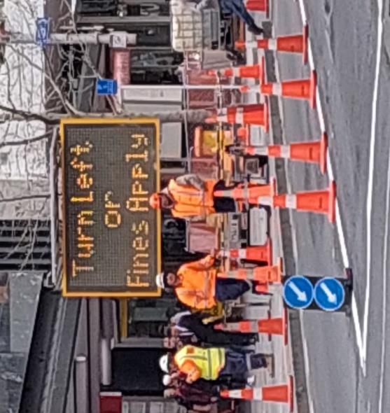
Queen Street (travelling south) EVA Approach7
Figure 11: Queen Street southbound EVA approach
Site Assessment
The general environment at this approach is characterised by many tall buildings, most
with awnings. The visual scene is noticeably more cluttered than the approaches at the
southern end of the EVA. There are many commercial signs including those on the Civic
Theatre. During observations there were also very heavy roadworks with associated
signage, and many road cones.
Queen St is a main road and a main bus route, so the traffic volumes are generally heavy
(moderate outside of peak hours). The roadworks have narrowed the street to only one
southbound lane. As such, drivers do not have to work to choose a correct lane or drive
with consideration to drivers in other lanes of traffic travelling the same direction.
However, they do have to navigate the roadworks. There are other road users present,
particularly buses, and at peak hours there are many pedestrians, cyclists, and scooter
users.
The roadway design at Queen St is yet to be finalised. There is a range of signage indicating
the EVA and who is allowed to enter it. This signage is quite small and not very conspicuous. In
7 Note, taking comprehensive photographs of a southbound driver’s point of view were not possible due
to roadworks at this site.
MACKIE RESEARCH QUEEN STREET: ESSENTIAL VEHICLES AREA EVALUATION
17
this situation, the signs seem insufficient (given behavioural observations). This is because the
heavy thoroughfare of buses through this intersection may block the view of some signage, the
visual clutter from the surroundings and the roadworks makes the signs inconspicuous, and the
complex driving environment requires a lot of attention. Additional signage indicating the
Wellesley Street W bus lane is present and is also relatively inconspicuous. Given behavioural
observations these signs also seem insufficient.
The core driving task is complex at this site. If drivers are aware of the EVA and what route
they wish to take the EVA does not add any additional workload. However, if they are not
aware of the EVA, then they must read signage, deduce that they can only turn left, and
plan a new route. This may involve pulling over if they are not familiar enough with the
CBD and it is difficult to find somewhere to do this. Because the high workload associated
with simply driving in the area, the extra route planning work may not be possible for
many drivers, especially given the number of restrictions in the CBD and the complexity of
identifying a viable new route. Due to this, drivers may be relying on other drivers in front of
them or feeling like they do not have sufficient time/confidence to quickly plan another route
and thus simply driving through the EVA.
Driver Behaviour Observations
Due to roadworks at the intersection of Wellesley and Queen streets, systematic
observation could not be undertaken. Multiple site visits to the intersection totalling
approximately 2.5 hours were instead used to develop general observations (see Appendix
A).
Commonly observed behaviours included vehicles approaching the intersection very
hesitantly—one driver was even seen stopping to talk to a road worker. Some drivers
seemed to realise that the EVA was ahead but could not confidently select another route
in time and, therefore, proceeded straight into the EVA (sometimes very hesitantly).
Many drivers were observed turning right into the Wellesley St W bus lane as they were
aware of the EVA, but not the Wellesley St W restrictions (or perhaps were aware of the
cameras and automatic infringements in the EVA and the absence of a bus lane camera on
Wellesley St W).
Prior to Queen St being narrowed to one southbound lane, drivers were seen stopping at
the intersection in the right lane before noticing the EVA, starting to indicate left, and
turning left into Wellesley St E from the right lane.
Other drivers were seen turning left into Wellesley St E before performing a U-turn
through the gap in the median traffic island and proceeding back through the intersection
and onto Wellesley St W.
Conclusions
The review of Queen St EVA southbound approach indicates that given the general
environment, traffic volume, and driving task, the signage for the EVA seems insufficient. It
is too small and inconspicuous to be reliably identified by drivers given the background
clutter—which is made worse by the complex roadworks currently in progress at the
intersection. This is evidenced by the number of drivers who proceeded into the EVA
without hesitation or turned up Wellesley St W.
MACKIE RESEARCH QUEEN STREET: ESSENTIAL VEHICLES AREA EVALUATION
18


Wayfinding is also an issue at this site, evidenced by the hesitating behaviour at the
intersection when drivers were attempting to plan another route, having expected to be
able to travel up Queen St. The hesitations, abrupt turns (sometimes from the wrong lane),
and unpredictable manoeuvres like U-turns are dangerous to other road users.
Improvements in communicating alternate routes are required.
3.5
Wellesley Street West EVA Approach
Figure 12: Wellesley Street West EVA approach
Site Assessment
The general environment at this approach is characterised by many tall buildings, most
with awnings. The visual scene is noticeably more cluttered than the entry points at the
southern end of the EVA. There are many commercial signs including those on the Civic
Theatre.
There are other road users present, particularly buses, and the area is becoming
increasingly pedestrianised. During observations there were many road users on the
footpath waiting for busses. Monitoring these road users adds to the complex ity of the
driving task.
Wellesley St W is a main road and a main bus route, so the traffic volumes are generally
heavy (moderate outside of peak hours). There are three traffic lanes including one bus
lane and several sets of traffic lights. Drivers must work to choose a correct lane and drive
with consideration to drivers in other lanes of traffic travelling the same direction. The
intersection which includes the right turn to the EVA has a left lane which is left turn only, a
middle lane is a straight-only bus lane, and a right lane which is both straight ahead and right-
turning. A large stretch of the left lane also doubles as a bus stop. The left lane is marked with a
left arrow, the centre lane is painted green and marked with the words, “BUS LANE”, and the
right lane is marked with a heavily worn hybrid straight and right arrow. The complex road
environment requires a lot of attention.
There is a range of signage indicating the EVA and who is allowed to enter it. Some signage pre-
warns drivers from as far back as the intersection between Wellesley St W and Elliott St.
However, this signage and the signage at the Queen St intersection is quite small and not very
conspicuous. In this situation, the signs seem insufficient (given behavioural observations).
Some of the signage is out of the driver’s eyeline, it is small and difficult to spot against the
clutter, the text is difficult to read, and signage can be obscured by busses and other large
vehicles.
MACKIE RESEARCH QUEEN STREET: ESSENTIAL VEHICLES AREA EVALUATION
19
The core driving task is very complex at this site. If drivers are aware of the EVA and what
route they wish to take they simply need to turn left or proceed straight at low speed
which does not add much workload. If they are not aware of the EVA, then they must read
the signage, deduce that they can only turn left or proceed straight, and plan a new route
while negotiating the complex roadway with a range of restrictions (such as bus lanes).
This may involve pulling over if they are not familiar enough with the CBD , although there
are limited opportunities to pull over in Wellesley St E (especially for traffic travelling in
the right lane who would need to change lanes before pulling over). Although the core
driving task is complex, the hybrid straight and right-turning lane allows for people to
change their route and proceed straight ahead without changing lanes if they are aware
they can do this. This is likely to be possible for most drivers.
Driver Behaviour Observations
Due to roadworks at the intersection of Wellesley and Queen streets, systematic
observation was unable to be undertaken. Multiple site visits to the intersection totalling
approximately 2.5 hours enabled general observations to be made (see full list in Appendix
A).
Some drivers were observed waiting at a red light in the right lane (indicating right to turn
into the EVA) before noticing the signage and driving straight through the intersection
(into Wellesley St E). Although some then made U-turns and travelled back along Wellesley
St W. Others were observed stopped at a red light for quite some time before turning into
the EVA with no indication that they had noticed the signage. On one occasion a vehicle in
the right turning lane seemed to notice the EVA and hesitated at the green light. A bus
behind began honking and the driver turned right into the EVA, seeming to know that the
area was restricted but not having the ability to change route and avoid it.
Conclusions
The review of Wellesley St W eastbound indicates that given the general environment,
traffic volume, and driving task, the signage for the EVA seems insufficient. At this site,
more than others, the signage was difficult to spot against the visual clutter. In addition,
drivers working hard to negotiate the complex environment are unlikely to be generally
scanning for additional information.
Behavioural observations also suggest that the signage and markings are not sufficiently
conspicuous, and that several drivers are not aware that they should not turn right at the
intersection.
It appeared that once drivers were aware of the EVA, they were able to re-plan relatively
easily to proceed straight.
MACKIE RESEARCH QUEEN STREET: ESSENTIAL VEHICLES AREA EVALUATION
20
3.6
Cross EVA Findings
Road environment design can greatly influence road users’ experiences of an area. Good road
environment design makes the roadway easy to understand and use and supports safe and
predictable behaviour of road users.
This review suggests that the road design at the approaches into the EVA has not been
successful in preventing unpermitted entry to the area—as indicated by the various
observations of EVA violations and the data collected by Auckland Transport. Although the
precise error types are not always possible to determine, our observations suggest that genuine
driver mistakes, through inadequate or confusing information is the main mechanism by which
drivers are choosing to enter the EVA area or alternatively change direction suddenly. The main
reasons for this appear to be that the signage is not sufficiently conspicuous, does not convey
clear information about the EVA to road users, and that alternate route planning is difficult at
some sites due to the general complexity of the driving task.
The core issues differ slightly by site. At the northern end of Queen St, the lack of conspicuous
signage (including some out of the line of sight) suggests some drivers simply do not see the
signs and fail to notice the EVA against the general clutter. It is also likely that additional
complexities related to navigating roadworks at the northern end of the EVA have contributed
to the general lack of awareness and high rate of violations from drivers.
For road users northbound on Queen St (at the southern end of the EVA), the site is less visually
complex, and the roadway is also. Signage appears to reliably alert drivers emerging from
Wakefield St and usually alert drivers travelling north on Queen St. Although the language on
some signs is unclear. For example, on the block between Karangahape Rd and Mayoral Dr, the
signage southbound says, “local access only”, and conflicts with the terminology used on all
other signage warning of the EVA. However, the primary issue at this site appears to be route
planning. The signage does not give those without prior knowledge of the EVA adequate time to
safely plan a new route and avoid the area. Also, the routes drivers need to take to avoid the
EVA are not particularly intuitive, potentially leaving drivers feeling they are travelling back the
way they came.
At both ends of the EVA the delayed perception and comprehension of the signage by some
road users and attempts to identify alternate routes under pressure have resulted in unsafe and
unpredictable behaviours from many of the observed vehicles (including U-turns in the middle
of intersections and through gaps traffic islands). This is dangerous to other road users.
MACKIE RESEARCH QUEEN STREET: ESSENTIAL VEHICLES AREA EVALUATION
21
link to page 23
4. RECOMMENDATIONS FOR EVA
The following recommendations are intended to improve the design of the EVA from a driver’s
perspective. They range from helping drivers plan their routes in advance, to ongoing
monitoring of driver behaviour at the EVA. The recommendations have been broken into five
areas:
• Route planning
• Roadway and signage design
• Tactical decision-making/real-time wayfinding
• Issuing infringement fines
• Tracking behaviour
1. Route Planning
Recommendation 1.1: Provide better route planning guidance
The route planning information identified during this review merely listed alternative roads that
could be used. To be useful to drivers, particularly those unfamiliar with the area, the
information would need to suggest specific routes for navigating around the EVA if travelling
north or south.
Ongoing monitoring of driver understanding of alternate routes should be undertaken so that
communications and route planning guidance can be targeted to areas of need.
2. Roadway and signage design
Recommendation 2.1: Develop EVA gateway signage
Recommendation 2.2: Improve conspicuity and legibility of all EVA signage
Recommendation 2.3: Use consistent terminology to communicate to drivers
The EVA is a new concept for New Zealand. Its unfamiliarity to drivers means that an extra
education effort is needed. A consistent change in behaviour is unlikely to be realised without
ongoing investment in communications and roadway design. This appears to be borne out by
the data collected on the EVA to date which has shown many violations.
At a concept level, we recommend developing gateway signage and road markings that connect
the EVA more closely to the broader story of the City Centre Masterplan and the vision for the
Waihorotiu/Queen Street Valley, communicating the ‘
why’ of the intervention. We recommend
making a feature of the EVA by making the ‘gateway’ visually eye-catching and including signs
explaining the EVA (perhaps with a QR code for easy access to more detailed information and
links to trip-planning guides). This should include large, uniquely colours signs with matching
pavement marking. Advanced signage should match the colours used and, if possible, a
consistent and recognisable logo or brand should be used.
Figure 13 on the following page shows an example of the gateway concept used for the London
Congestion Zone. This example doesn’t contain all the elements suggested above but does
provide an idea of what a gateway may look like.
MACKIE RESEARCH QUEEN STREET: ESSENTIAL VEHICLES AREA EVALUATION
22
 Figure 13: London Congestion Charging Zone.8
In terms of general signage related to the EVA, the review showed that although there seemed
to be some effective and clear advanced signage, much of the EVA signage was small, difficult to
spot against the background and difficult to read. This was particularly problematic at the
northern end of the EVA, and not helped by current roadworks.
Overall, the signs need to be more conspicuous. It was noted during the review that the blue
ADS sign stood out well against the visual background as it is not a common colour at the site.
Using this colour and increasing sign size as well as better placement may help drivers notice
the signs. Where possible signs should be placed where drivers typically scan rather than high
up or a long way off the roadway. However, given the complexity of the site, this may not
always be possible.
To embed recognition and understanding the signage must have consistency in language,
symbols, and colours to ensure that it is predictable to road users. Over time, this reduces the
amount of attention road users need to pay to the signs as they learn to identify them with a
quick glance. As a result, they can pay attention to safety critical things such as monitoring for
pedestrians and cyclists.
Upon review of various materials provided, and multiple site visits to the EVA, it was evident
that a variety of terminology has been used across the EVA and that it is assumed that the
public is familiar with all of them. Signage refers to the area being a ‘bus lane’, ‘GV lane’, ‘bus
GV lane’ and ‘local access only’. This variation could cause confusion for some road users,
especially when the wording on signs conflicts with the wording of road markings. A review of
existing signage and terminology may be needed to ensure that the existing EVA signage is not
unnecessarily confusing.
8
http://forums.pepipoo.com/lofiversion/index.php/t116534.html
MACKIE RESEARCH QUEEN STREET: ESSENTIAL VEHICLES AREA EVALUATION
23
link to page 24

3. Tactical decision-making and real-time wayfinding
Recommendation 3.1: Support real-time wayfinding
Route planning once drivers find themselves at the EVA is quite complex in some directions (see
Figure 15). For this reason, real-time route planning could significantly reduce risks to the driver
and other road users.
Figure 14: Example of route finding around Queen Street EVA from southbound on Queen Street (directions
sourced from google maps 2022)
While it is very difficult to provide wayfinding/route planning information to drivers in real-time
once they find themselves confronted with the EVA, it may be possible to identify specific sites
where many drivers are having difficulty and install route-finding, informational signage.
If possible, these sites should include pull-over areas so that drivers can safely pull off to read
sign. Including a QR code on the sign for drivers to scan from the car would provide them with
information to use as they navigate the alternate route.
Areas around the EVA where behaviour observations suggest route finding guidance may be
useful are:
• Drivers southbound on Queen St (many drivers observed starting to turn left onto
Wellesley St E, proceeding up it, performing a U-turn, and then turning left onto
Mayoral Dr (eastbound Wellesley St E drivers are not permitted to turn right onto
Mayoral Dr).
• Drivers travelling northbound on Queen Street (a significant number of drivers were
seen turning into Rutland Street and then turning around to exit it again. Clear signage
indicating the no exit/thoroughfare is highly recommended for the Wakefield Street
Rutland Street intersection).
MACKIE RESEARCH QUEEN STREET: ESSENTIAL VEHICLES AREA EVALUATION
24
4. Issuing infringement fines
Recommendation 4.1: Delay issuing infringement fines
In hindsight, it may have been better to ensure that the EVA was not introduced while extensive
roadworks were still being undertaken in the area (particularly at the intersection of Queen and
Wellesley streets). The complexity and clutter generated by the roadworks has greatly hindered
people’s ability to recognise and avoid the EVA. The soft launch of infringement fines (following
warning notices) does well to allow for first-time errors. However, if the number of repeat
offenders continues to remain high, it is recommended that infringement fines are not issued
until roadworks are complete.
5. Tracking behaviour
Recommendation 5.1: Monitor driver behaviour
In addition to monitoring people’s understanding of the EVA, we recommend tracking
driver compliance. High levels of non-compliance persisting over time suggest that the
scheme is fundamentally not user-friendly to drivers and further remediation is needed.
Alternatively, drivers may eventually habituate to the scheme when experience or word of
enforcement spreads even with sub-standard signage. However, this would seem unfair for
new drivers who are unfamiliar with the area, and background information, advanced
signage and threshold signage should do at least a reasonable job of alerting new drivers
to a non-access area.
Monitoring should include tracking driver awareness of the EVA, understanding of the rules
relating to it, behaviour when navigating it and knowledge of alternate routes is recommended
so that the most appropriate communications can be planned.
MACKIE RESEARCH QUEEN STREET: ESSENTIAL VEHICLES AREA EVALUATION
25
APPENDIX A. DRIVER BEHAVIOUR OBSERVATIONS
Observations were only recorded for all vehicles except buses. Utes are recorded separately from cars as there appears to be a loophole that allows them
to enter the EVA as the rules stand.
Location observed: Wakefield St North-Westbound Date: 21/09/2022 Time: 10:15-11:15 AM
Performed
Vehicle
Leader/
Use (if
Lights on
Behavioural Observations
Used EVA
manoeuvre
Type
follower
possible)
approach
to avoid
Had approached the lights and stopped approximately 5 metres back. The
driver from the car behind got out of their vehicle and told the driver to pull
Car
Leader
Private
Red
No
No
forward further. The light was not activated until they pulled forward. Indicated
left. Turned left (southbound on Queen St).
Indicated left on approach. Stopped and got out to speak to the driver of the
Car
Follower
Private
Red
No
No
vehicle in front. Turned left (southbound on Queen St).
Car
Follower
Private
Red
Indicated left on approach. Turned left (southbound on Queen St).
No
No
Car
Follower
Private
Red
Indicated left on approach. Turned left (southbound on Queen St).
No
No
Tow truck
Leader
Commercial Red
Did not indicate. Turned right (northbound on Queen St).
Yes
No
Van
Follower
Commercial Red
Indicated left on approach. Turned left (southbound on Queen St).
No
No
Indicated left on approach. Turned left (southbound on Queen St). Drove very
Car
Leader
Private
Red
slowly around the corner. Hesitated, potentially to read the ‘no right turn’ sign
No
No
across the intersection.
People
Leader
Private
Red
Indicated left on approach. Turned left (southbound on Queen St).
No
No
mover
Indicated left on approach. Turned left (southbound on Queen St). Hesitated,
Car
Leader
Private
Red
No
No
potentially to read the ‘no right turn’ sign across the intersection.
MACKIE RESEARCH QUEEN STREET: ESSENTIAL VEHICLES AREA EVALUATION
26
Did not indicate on approach. Turned on left indicator after sitting at the lights
Car
Leader
Private
Red
for a few seconds. Inched forward when another direction had a green light.
No
No
Turned left (southbound on Queen St).
Approached quite slowly as a pedestrian jaywalked in front of them. Started
Car
Leader
Private
Red
indicating left once they stopped. Inched towards the line. Turned left
No
No
(southbound on Queen St).
Did not indicate on approach. Stopped at light. Indicated right, then switched to
Car
Leader
Private
Red
No
No
indicating left. Turned left (southbound on Queen St).
Indicated left on approach. Light turned green just as they approached. Turned
left (southbound on Queen St). Pulled into a mobility park on the left just after
Car
Leader
Private
Green
the traffic lights, then immediately pulled back into traffic to continue
No
No
southbound. Potentially considered stopping to check directions/alternate
routes.
Indicated left on approach. Turned left (southbound on Queen St). Turned the
Car
Leader
Private
Red
corner at a moderate speed, seemed to glance across the intersection at the
No
No
‘no right turn’ sign.
Did not indicate on approach. Turned left (southbound on Queen St) on an
Car
Leader
Private
Orange
No
No
orange light.
Did not indicate on approach. Indicated left as they stopped at the light. Waited
at the green light for a pedestrian who jaywalked in front of them. Turned left
Car
Leader
Private
Red
No
No
(southbound on Queen St) quite slowly. Looked around at the pedestrians
waiting at the intersection.
Had driven south-eastbound up Wakefield St. Performed a U-turn and
Car
Leader
Commercial Red
approached the intersection without indicating. Indicated left after waiting at
No
No
the lights for a few seconds. Turned left (southbound on Queen St).
Tow truck
Follower
Commercial Red
Did not indicate on approach. Turned right (northbound on Queen St).
Yes
No
Car
Follower
Private
Red
Indicated left on approach. Turned left (southbound on Queen St).
No
No
MACKIE RESEARCH QUEEN STREET: ESSENTIAL VEHICLES AREA EVALUATION
27
Turned left out of Rutland St and drove south-eastbound up Wakefield St.
Truck
Leader
Commercial Red
Performed a U-turn and approached the intersection without indicating.
Yes
No
Indicated right. Turned right (northbound on Queen St).
Slowly approached without indicating and missed the green light. Driver was
Ute
Leader
Private
Green
potentially looking at a phone while driving. Indicated left after being stopped
No
No
at the lights for around 5 seconds. Turned left (southbound on Queen St).
Honked horn on approach. Did not indicate on approach. Turned left
(southbound on Queen St) quite slowly. Seemed to glance across the
intersection at the ‘no right turn’ sign. Pulled into the mobility parking on the
Car
Leader
Private
Red
left on Queen St. One passenger got out and walked around on the footpath for
Yes
No
a few minutes. Seemingly unbelted children in the back. Pulled out in front of
traffic to do a U-turn and stopped at the lights. Drove slowly through the
intersection and into the EVA (northbound on Queen St).
Stopped about 15m back from the intersection. Put hazard lights on and let out
Car
Leader
Rideshare
Red
two passengers. Turned off hazard lights and drifted forward a few metres. U-
No
Yes
turned to drive south-eastbound up Wakefield St and avoid the traffic lights.
Car
Leader
Rideshare
Red
Indicated left on approach. Turned left (southbound on Queen St).
No
No
Ute
Leader
Private
Red
Indicated left on approach. Turned left (southbound on Queen St).
No
No
Car
Leader
Private
Red
Indicated left on approach. Turned left (southbound on Queen St).
No
No
Stopped about 30m back from the intersection. Let out one passenger. U-
Car
Leader
Rideshare
Red
No
Yes
turned to drive south-eastbound up Wakefield St and avoid the traffic lights.
Motorcycle
Leader
Private
Red
Did not indicate on approach. Turned right (northbound on Queen St).
Yes
No
Did not indicate on approach. Inched forward when pedestrians had a green
light. Started indicating right when the light turned green. Drove into the
Car
Leader
Private
Red
intersection and did a U-turn around the island to turn into Rutland St
No
Yes
(eastbound). Turned around and approached the Rutland St intersection again.
Turned left out of Rutland St and drove south-eastbound up Wakefield St.
Ute
Leader
Commercial Red
Indicated left on approach. Turned left (southbound on Queen St).
No
No
MACKIE RESEARCH QUEEN STREET: ESSENTIAL VEHICLES AREA EVALUATION
28
Did not indicate on approach. Indicated left once the light turned green. Turned
Car
Follower
Private
Red
No
No
left (southbound on Queen St) late on an orange light.
Indicated left on approach. Turned left (southbound on Queen St) on a red
Car
Follower
Private
Red
No
No
light.
Car
Leader
Private
Red
Indicated left on approach. Turned left (southbound on Queen St).
No
No
Truck
Follower
Commercial Green
Indicated left on approach. Turned left (southbound on Queen St).
No
No
Car
Leader
Private
Red
Indicated left on approach. Turned left (southbound on Queen St).
No
No
Turned left out of Rutland St. Immediately performed a U-turn around the
traffic island and stopped at the lights. Did not indicate. Turned left
Car
Follower
Private
Red
No
No
(southbound on Queen St). Pulled into the mobility parking on the left on
Queen St.
Indicated left on approach. Light turned green just as they approached. Turned
Car
Leader
Private
Green
No
No
left (southbound on Queen St).
Car
Leader
Private
Red
Indicated left on approach. Turned left (southbound on Queen St).
No
No
Did not indicate on approach. Turned left (southbound on Queen St) quite
Campervan
Leader
Commercial Red
No
No
slowly.
Did not indicate on approach. Inched forwards at the red light. Obviously
Car
Leader
Private
Red
confused as they did not move forward on the green light. Began moving
No
No
forward on the orange light. Turned left (southbound on Queen St).
Indicated left on approach. Started to turn left. Completely stopped in the
Car
Leader
Private
Red
middle of the intersection for a few seconds. Continued southbound on Queen
No
No
St.
Drove on the wrong side of the road to turn right into Rutland St. Turned
Car
Follower
Private
Red
around and approached the Rutland St intersection again. Turned left out of
No
Yes
Rutland St and drove south-eastbound up Wakefield St.
Tow truck
Leader
Commercial Red
Did not indicate on approach. Turned left (southbound on Queen St).
No
No
MACKIE RESEARCH QUEEN STREET: ESSENTIAL VEHICLES AREA EVALUATION
29
Drove on the wrong side of the road to turn right into Rutland St. Parked on the
Truck
Leader
Commercial Red
No
No
left.
Car
Leader
Private
Red
Indicated left on approach. Turned left (southbound on Queen St).
No
No
Car
Follower
Private
Red
Indicated left on approach. Turned left (southbound on Queen St).
No
No
Indicated left on approach. Made a tight left turn on a red light and mounted
Truck
Follower
Commercial Red
No
No
the footpath to park in the middle of the paved pedestrian area.
Turned left out of Rutland St. Immediately performed a U-turn around the
Truck
Leader
Commercial Red
traffic island and stopped at the lights. Indicated right. Turned right
Yes
No
(northbound on Queen St).
Location observed: Queen St Northbound Date: 22/09/2022 Time: 10:25-11:25 AM
Performed
Vehicle
Leader/
Use (if
Lights on
manoeuvre
Behavioural Observations
Used EVA
Type
follower
possible)
approach
to avoid
EVA
Approached in right lane without indicating. Hesitated in the middle of the
intersection to decide which right turn to take. Turned into Rutland St. Turned
Car
Leader
Private
Red
No
No
around and approached the Rutland St intersection again. Turned left out of
Rutland St and drove south-eastbound up Wakefield St.
Ute
Leader
Commercial Red
Approached in right lane indicating right. Turned right into Rutland St.
No
No
Approached in right lane. Changed into left (bus) lane without indicating.
Ute
Leader
Private
Red
Hesitated when the light turned green (could have been due to distraction or
Yes
No
being unsure). Drove straight ahead into the EVA.
Car
Follower
Private
Green
Approached in left (bus) lane. Drove straight ahead into the EVA.
Yes
No
Approached and did a U-turn at the Airedale St intersection. Continued
Truck
Leader
Commercial
-
No
Yes
Southbound up Queen St.
Approached in right lane indicating right. Crossed over centre lane to partially
Forklift
Leader
Commercial Red
Yes
No
enter left (bus) lane. Proceeded straight through the EVA.
MACKIE RESEARCH QUEEN STREET: ESSENTIAL VEHICLES AREA EVALUATION
30
Approached in right lane without indicating. Turned right into Rutland St.
Turned around and approached the Rutland St intersection again indicating left.
People
Follower
Private
Green
Had right-of-way but stopped at the intersection for upwards of 10 seconds.
No
No
mover
Eventually turned left out of Rutland St and drove south-eastbound up
Wakefield St.
Approached in right lane without indicating. Driver leaned forward to look at
Car
Leader
Private
Red
No
No
signage. Started indicating right once stopped. Turned right into Rutland St.
Car
Follower
Private
Red
Approached in right lane without indicating. Turned right into Wakefield St.
No
No
Approached in right lane and started indicating left. Turned off left indicator
Car
Leader
Private
Red
No
No
and turned on right indicator. Turned right into Rutland St.
Truck
Follower
Commercial Red
Approached in right lane without indicating. Turned right into Rutland St.
No
No
Approached in right lane without indicating. Proceeded straight through on an
Van
Follower
Private
Red
Yes
No
orange light into the EVA.
Car
Leader
Private
Red
Approached in right lane indicating right. Turned right into Wakefield St.
No
No
People
Approached in right lane. Began indicating right after stopping behind the
Follower
Private
Red
No
No
mover
indicating car in front. Turned right into Wakefield St.
Approached in right lane. Began moving into the left (bus) lane without
Car
Follower
Private
Red
No
No
indicating. Turned right on a red light into Wakefield St.
Approached in right lane. Turned right on a red light. Hesitated in the
Car
Follower
Private
Red
No
No
intersection for a few seconds before deciding to turn into Rutland St.
Approached in right lane indicating right. Turned right very slowly. Braked in the
Car
Leader
Private
Red
No
No
middle of the intersection. Turned right into Wakefield St.
Car
Follower
Private
Red
Approached in right lane indicating right. Turned right into Rutland St.
No
No
Approached in right lane without indicating. Turned right on a late orange into
Car
Follower
Private
Red
No
No
Wakefield St.
MACKIE RESEARCH QUEEN STREET: ESSENTIAL VEHICLES AREA EVALUATION
31
Approached in right lane indicating right. Waited at the green light for an
Truck
Leader
Commercial Red
oncoming (southbound) truck running a red light. Turned right into Rutland St
No
No
and pulled over on the left to make a delivery (hazard lights on).
Car
Leader
Private
Red
Approached in right lane indicating right. Turned right into Wakefield St.
No
No
Approached in right lane. Turned right into Airedale St. Turned around and
Van
Follower
Private
-
approached the Airedale St intersection again. Turned left out of Airedale St
No
No
and drove southbound up Queen St.
Approached in right lane without indicating. Began indicating after stopping
People
Follower
Private
Red
behind the indicating car in front. Hesitated at the green light and then turned
No
No
mover
right into Rutland St.
Slowly approached in right lane without indicating. Began indicating right once
Car
Leader
Private
Red
No
No
stopped. Turned right into Wakefield St.
Slowly approached in right lane without indicating. Began indicating after the
Car
Follower
Private
Red
No
No
car in front began indicating. Turned right into Wakefield St.
Approached in right lane without indicating. Began indicating when the light
turned green. Turned right into Rutland St. Turned around and approached the
Car
Leader
Police
Red
No
No
Rutland St intersection again. Turned left out of Rutland St and drove south-
eastbound up Wakefield St.
Approached in right lane without indicating. Slowly pulled up to the red light
behind the police car. Inched forward on the green arrow but did not proceed
Car
Follower
Private
Red
through before it turned red. Came to a stop just over the line. Turned right
No
No
indicator on and then off. Waited for the next green arrow and turned right into
Wakefield St.
Approached in right lane without indicating. Driver looked confused and
Car
Leader
Private
Red
gestured to the passenger about the lanes ahead. Turned on right indicator
No
No
once stopped. Turned right into Wakefield St.
Approached in right lane without indicating. Turned on right indicator once
Car
Leader
Private
Red
stopped. Inched forward on the red light. Hesitated on the far side of the
No
No
intersection and turned into Rutland St. Turned around and approached the
MACKIE RESEARCH QUEEN STREET: ESSENTIAL VEHICLES AREA EVALUATION
32
Rutland St intersection again. Turned left out of Rutland St and drove south-
eastbound up Wakefield St.
Approached in right lane without indicating. Turned on right indicator once
Car
Leader
Private
Red
stopped. Hesitated on the far side of the intersection and turned right into
No
No
Rutland St. Pulled over on the left to park.
Approached and did a U-turn at the Airedale St intersection. Continued
Truck
Leader
Commercial -
No
Yes
Southbound up Queen St.
Van
Leader
Private
Red
Approached in right lane indicating right. Turned right into Wakefield St.
No
No
Approached in right lane without indicating. Hesitated on the far side of the
Car
Follower
Private
Red
No
No
intersection and turned right into Wakefield St.
Approached in right lane without indicating. Proceeded straight through from
Car
Follower
Private
Red
Yes
No
the right lane (on a green light with a red arrow) into the EVA.
Approached in right lane without indicating. Proceeded straight through from
the right lane (on a green light with a red arrow) to the exact threshold of the
Car
Follower
Private
Red
No
Yes
EVA. Quickly performed a U-turn to avoid entering the EVA. Turned left into
Rutland St.
Approached in right lane without indicating. Changed into the left (bus) lane
Van
Leader
Commercial Red
without indicating. Proceeded straight through into the EVA. Braked slightly at
No
No
the threshold.
Approached from the Mayoral Dr intersection in the left (bus) lane. Changed
Car
Leader
Private
Red
into the right lane. Changed back into the left (bus) lane at the intersection.
Yes
No
Waited for the green light. Proceeded straight through into the EVA.
Approached from the Mayoral Dr intersection in the left (bus) lane. Changed
into the right lane. Indicated left and followed the car in front to change into
Car
Follower
Private
Red
Yes
No
the left (bus) lane. Stopped mostly in the bus lane. Waited for the green light.
Proceeded straight through into the EVA.
Car
Follower
Private
Red
Approached from the Mayoral Dr intersection in the left (bus) lane. Changed
Yes
No
into the right lane. Followed the car in front to change into the left (bus) lane.
MACKIE RESEARCH QUEEN STREET: ESSENTIAL VEHICLES AREA EVALUATION
33
Stopped half in the bus lane. Waited for the green light. Proceeded straight
through into the EVA.
Approached from the Mayoral Dr intersection in the left (bus) lane. Changed
into the right lane. Indicated left and copied the car in front to angle towards
Car
Follower
Private
Red
Yes
No
the left (bus) lane. Waited for the green light. Proceeded straight through into
the EVA.
Food
Motorcycle
Follower
Red
Approached in the right lane. Turned right into Rutland St.
No
No
delivery
Approached in the right lane. Changed into the left (bus) lane. Turned on
Ute
Leader
Private
Red
hazard lights in the middle of the intersection. Proceeded straight through into
Yes
No
the EVA.
Approached in the right lane. Changed into the left (bus) lane. Indicated right in
Car
Follower
Private
Red
Yes
No
the middle of the intersection. Proceeded straight through into the EVA.
Approached in the right lane indicating right. Slowly turned right into Wakefield
Car
Leader
Private
Red
No
No
St.
Approached in the right lane without indicating. Hesitated on the far side of the
Car
Follower
Private
Red
No
No
intersection and turned right into Wakefield St.
Approached in the right lane without indicating. Drifted slightly into the left
(bus) lane and then returned to the right lane. Stopped at the light. Reversed a
Car
Leader
Rideshare
Red
few metres back from the line. Performed a U-turn then immediately pulled
No
Yes
over the left to drop off two passengers in a mobility park. Continued
southbound up Queen St.
Approached in right lane. Performed a three-point-turn manoeuvre at the
Car
Leader
Private
Red
No
Yes
Airedale St intersection and continued southbound up Queen St.
Approached in the right lane without indicating. Very slowly pulled up to the
light. Very slowly turned right into Rutland St. Turned around and approached
Car
Leader
Private
Red
No
No
the Rutland St intersection again. Turned left out of Rutland St and drove south-
eastbound up Wakefield St.
MACKIE RESEARCH QUEEN STREET: ESSENTIAL VEHICLES AREA EVALUATION
34
Approached in the right lane. Indicated left to change into the left (bus) lane.
Car
Leader
Private
Red
Yes
No
Hesitated on the green light. Proceeded straight through into the EVA.
Approached in the right lane. Indicated left to change into the left (bus) lane.
Van
Follower
Commercial Red
Yes
No
Proceeded straight through into the EVA.
Auckland
Approached in the right lane. Indicated left to change into the left (bus) lane.
Truck
Follower
Red
Yes
No
Council
Proceeded straight through into the EVA.
Flatbed
Approached in the right lane. Indicated left but stayed in the right lane. Stopped
Follower
Commercial Green
No
No
truck
on the red arrow and started indicating right. Turned right into Wakefield.
Approached straddling both lanes. Changed into the right lane. Turned right
Car
Leader
Private
Red
No
No
into Wakefield St.
Approached in the right lane without indicating. Pointed their wheels towards
Car
Follower
Private
Red
the left (bus) lane and then shifted them back. Turned right and hesitated on
No
No
the far side of the intersection. Settled on proceeding up Wakefield St.
Approached in the right lane without indicating. Started indicating right. Turned
Car
Follower
Private
Red
No
No
on a late orange into Rutland St.
Car
Leader
Private
Red
Approached in the right lane indicating right. Turned right into Rutland.
No
No
Car
Follower
Private
Red
Approached in the right lane without indicating. Turned right into Rutland.
No
No
Van
Leader
Commercial Red
Approached in the right lane without indicating. Turned right into Wakefield.
No
No
Approached in the right lane without indicating. Turned right on a late orange
Car
Follower
Private
Red
No
No
light and drove slowly up Wakefield.
Approached in the right lane indicating right. Turned right on a red light into
Car
Follower
Private
Red
No
No
Wakefield St.
Approached in the right lane without indicating. Proceeded straight through
Motorcycle
Leader
Private
Red
Yes
No
into the EVA.
Approached in the right lane. Indicated left and changed into the left (bus) lane.
Car
Leader
Private
Red
Yes
No
Proceeded straight through into the EVA.
MACKIE RESEARCH QUEEN STREET: ESSENTIAL VEHICLES AREA EVALUATION
35
Approached in the right lane. Indicated left and changed into the left (bus) lane.
Truck
Follower
Commercial Red
Yes
No
Proceeded straight through into the EVA.
Ute
Follower
Private
Red
Approached in the left (bus) lane. Proceeded straight through into the EVA.
Yes
No
Car
Leader
Private
Red
Approached in the right lane without indicating. Turned right into Wakefield St.
No
No
Food
Motorcycle
Follower
Red
Approached in the right lane without indicating. Turned right into Rutland St.
No
No
delivery
Car
Follower
Private
Red
Approached in the right lane without indicating. Turned right into Rutland St.
No
No
Approached in the right lane without indicating. Proceeded straight into the
Car
Follower
Private
Red
EVA from the right lane. Merged in between two buses travelling northbound
Yes
No
from the left (bus) lane.
Approached very slowly in the right lane without indicating. Changed into the
Van
Leader
Private
Red
Yes
No
left (bus) lane. Proceeded straight through into the EVA.
Approached in the right lane without indicating. Changed into the left (bus)
Car
Follower
Private
Red
Yes
No
lane. Proceeded straight through into the EVA.
Pulled out from a taxi stand on the left. Changed into right lane indicating right.
Truck
Leader
Commercial Red
No
No
Turned right into Wakefield St.
People
Approached in the right lane without indicating. Changed into the left (bus)
Follower
Private
Red
Yes
No
mover
lane. Proceeded straight through into the EVA behind a bus.
Approached in the right lane without indicating. Changed into the left (bus)
Van
Leader
Commercial Red
No
No
lane. Proceeded straight through into the EVA behind a bus.
Approached in the right lane without indicating. Indicated right as the light
Car
Leader
Private
Red
No
No
turned green and turned right into Wakefield St.
Location observed: Queen St Southbound Date: 14,21,22,23/09/2022
Behaviour Type
Behavioural Observation
• Road users were observed trying to determine where to turn to avoid the EVA. They could be seen leaning forward in their seat to
Avoiding the EVA
read the signage and could be seen gesturing to passengers. One road user stopped and held up traffic to talk to a construction
worker.
MACKIE RESEARCH QUEEN STREET: ESSENTIAL VEHICLES AREA EVALUATION
36
• When two southbound lanes were in place people could be seen abruptly turning left onto Wellesley St E from the right lane.
• Road users were often seen changing which way they indicated after sitting at the red light for a short while.
• When the first vehicle avoided the EVA it often cued others behind to do the same. Conversely, when one vehicle proceeded through
the EVA a run of other vehicles was often observed following—perhaps without realising, or perhaps assuming that the driver in front
EVA use (presumed
of them knew something they did not.
violations)
• Some road users seemed to recognise that they should not use the EVA ahead but had not been able to plan an alternate route, and
thus committed to (hesitantly) driving through the EVA.
• Some road users were observed approaching the intersection presumably intending to drive straight. Upon noticing the EVA ahead,
they changed their planned route and began indicating right. They did not observe or disregarded the ‘no right turn’ sign and bus
Wellesley St W bus lane
lane signage. The road users then turned right into Wellesley St W.
violation
• Some road users were observed turning left onto Wellesley St E, performed a U-turn through gap in a traffic island (a courtesy
pedestrian crossing) and proceeding back through the intersection westbound on Wellesley St W (using the bus lane).
Location observed: Wellesley St W Eastbound Date: 14,21,22,23/09/2022
Behaviour Type
Behavioural Observation
• Some road users were observed indicating right in the right turning lane. Upon recognising the EVA, they were able to continue
Avoiding the EVA
straight onto Wellesley St E (without needing to change lanes).
• Several vehicles were noted turning right out of Wellesley St W, having sat in queue of traffic for some time, and therefore having
EVA use (presumed
had a long time to see the signs.
violations)
• One vehicle was observed sitting stationary in the right turning lane while on a green light, before being honked at by a bus behind
them and then turning right into the EVA.
MACKIE RESEARCH QUEEN STREET: ESSENTIAL VEHICLES AREA EVALUATION
37