
 Project:
Links to Glen Innes Cycleways
Title:
2022 Addendum to Single Stage Business Case
Document Reference: P:\Stan\097 Links to Glen Innes- Business Case Addendum 2022 -
SO\4.0 Reporting\R1B220929 Links to GI 2022 Addendum to Single
Project:
Links to Glen Innes Cycleways
Title:
2022 Addendum to Single Stage Business Case
Document Reference: P:\Stan\097 Links to Glen Innes- Business Case Addendum 2022 -
SO\4.0 Reporting\R1B220929 Links to GI 2022 Addendum to Single
Stage Business Case.docx
Prepared by:
Reviewed by:
Revisions:
Date
Status
Reference
Approved by
Initials
21 September 2022
Version A
R1A220921
KM
29 September 2022
Version B
R1B220929
KM
The drawings, information and data recorded in this document (the information) are the property of Flow Transportation Specialists
Ltd. This document and the information are solely for the use of the authorised recipient and this document may not be used, copied
or reproduced in whole or part for any purpose other than that for which it was supplied by Flow Transportation Specialists Ltd. Flow
Transportation Specialists Ltd makes no representation, undertakes no duty and accepts no responsibility to any third party who may
use or rely upon this document or the information.

Links to Glen Innes
2022 Addendum to Single Stage Business Case
i
EXECUTIVE SUMMARY
Flow Transportation Specialists (Flow) has been commissioned by Auckland Transport to provide an
addendum to the Links to Glen Innes Cycleways Single Stage Business Case (SSBC). The SSBC was
completed for the project in 2020, and a previous addendum in 2021 included updates to:
The Strategic Case following new and updated National and Regional Strategic documentation.
Update on Stakeholder engagement and consultation
Preferred option update and assessment
Recommended option economic assessment
Updated performance measures
This subsequent 2022 addendum provides an update to:
Update on Stakeholder engagement and consultation
Preferred option update and assessment
Recommended option economic assessment
This addendum consolidates the previous investigations and options assessments and provides a clear
and concise justification for the preferred option, which supports higher quality cycling facilities.

Links to Glen Innes
2022 Addendum to Single Stage Business Case
ii
CONTENTS
1
BACKGROUND .................................................................................................................................. 3
1.1
Changes following completion of 2021 SSBC addendum ...................................................... 4
2
STAKEHOLDER AND PUBLIC CONSULTATION ................................................................................... 5
2.1
Overview ................................................................................................................................ 5
2.2
Feedback received .................................................................................................................. 5
2.3
Outcomes from stakeholder and public consultation ........................................................... 6
3
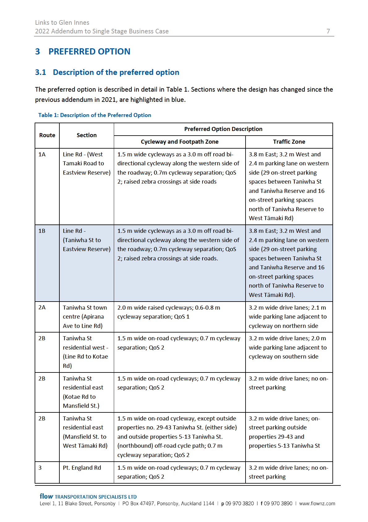
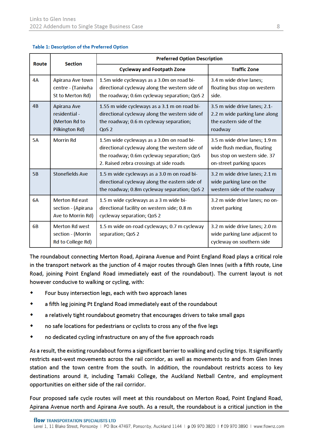
PREFERRED OPTION ......................................................................................................................... 7
3.1
Description of the preferred option ....................................................................................... 7
3.2
Preferred option assessment ................................................................................................. 9
4
RECOMMENDED OPTION ECONOMIC EVALUATION ..................................................................... 14
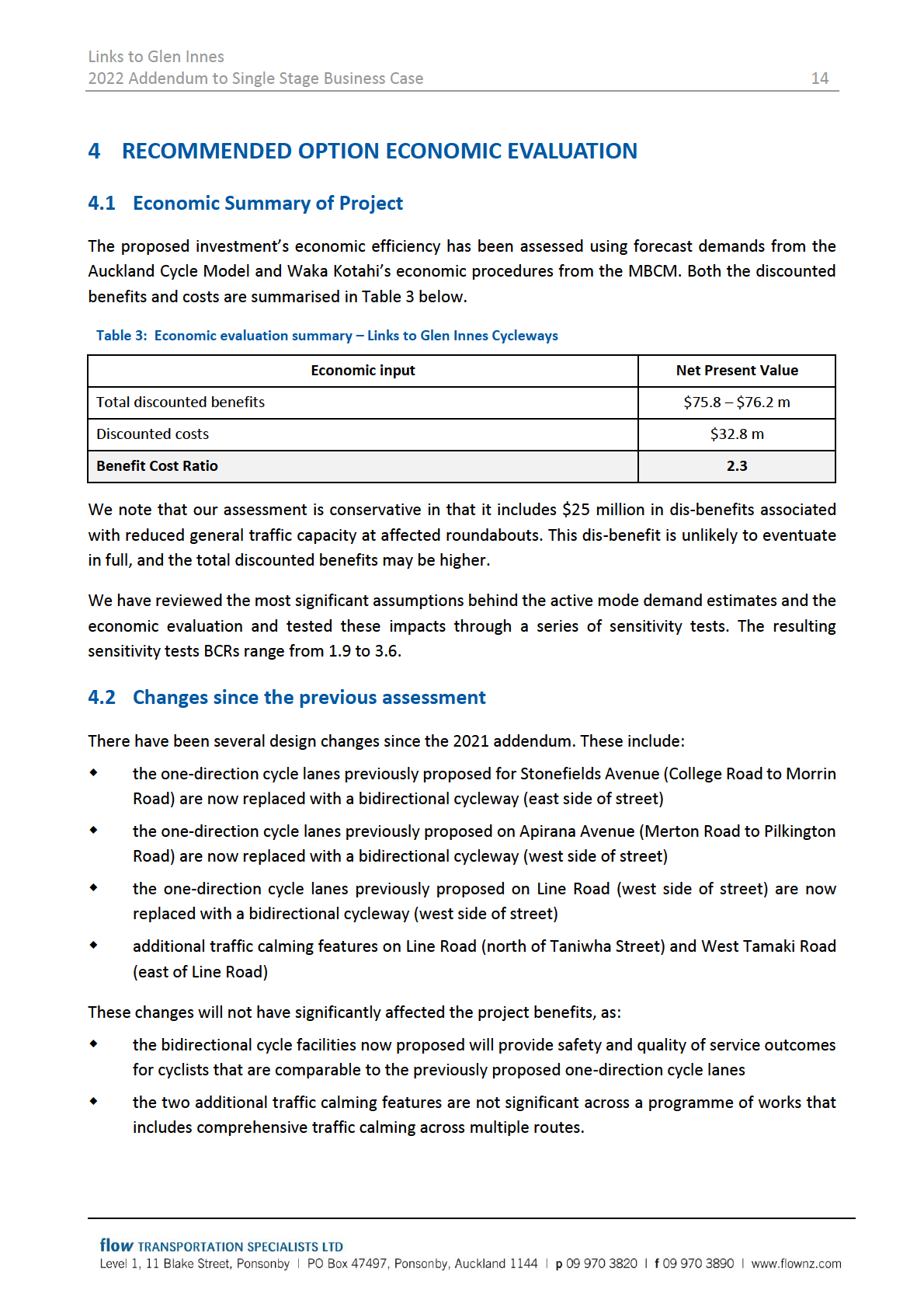
4.1
Economic Summary of Project ............................................................................................. 14
4.2
Changes since the previous assessment .............................................................................. 14
4.3
Benefit Streams .................................................................................................................... 15
4.4
Project Costs ......................................................................................................................... 15
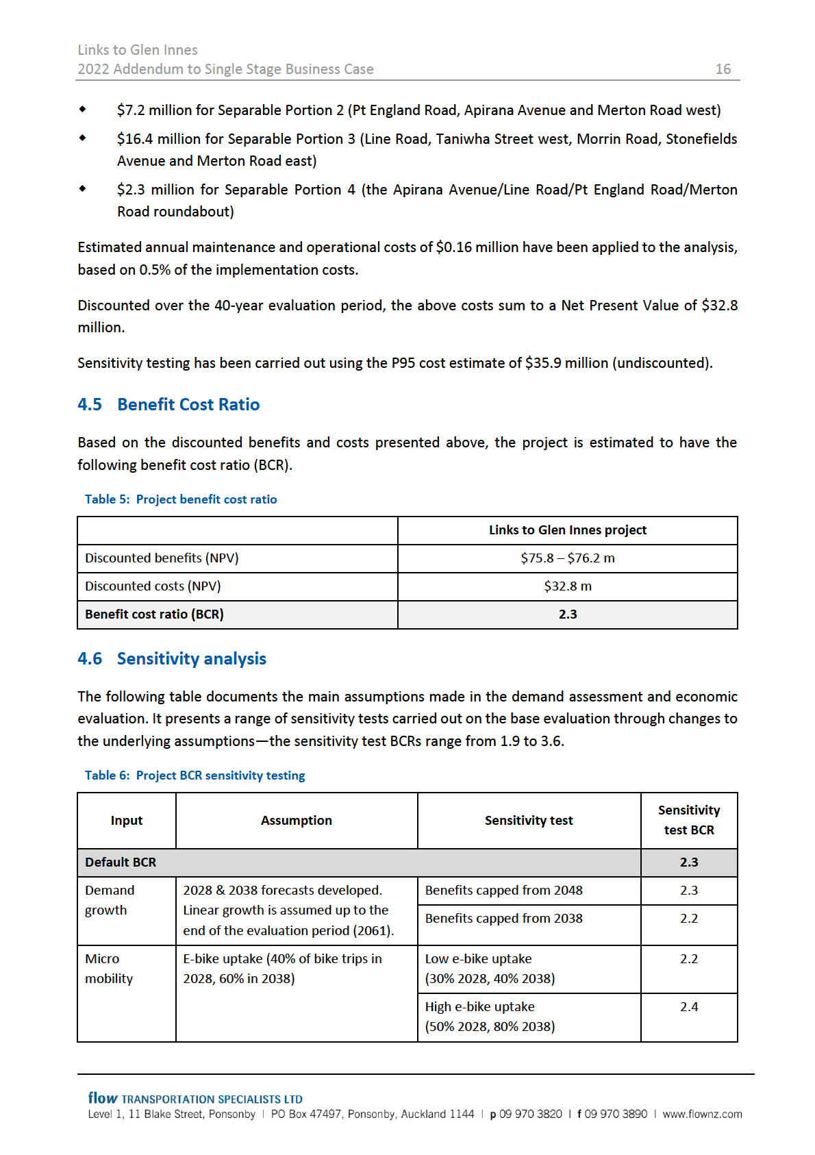
4.5
Benefit Cost Ratio ................................................................................................................. 16
4.6
Sensitivity analysis ................................................................................................................ 16
4.7
Investment assessment framework rating .......................................................................... 19
4.8
Investment performance measures ..................................................................................... 19

Links to Glen Innes
2022 Addendum to Single Stage Business Case
3
1 BACKGROUND
The case for investing in cycling within Auckland was established by Auckland Transport’s Auckland
Cycling Programme Business Case (PBC) in 2017. The PBC gained funding for a 10-year programme of
investment across the region, focussing on
trips most likely to be undertaken by bike, being short trips to jobs and education
communities with the greatest potential for cycling and the highest need
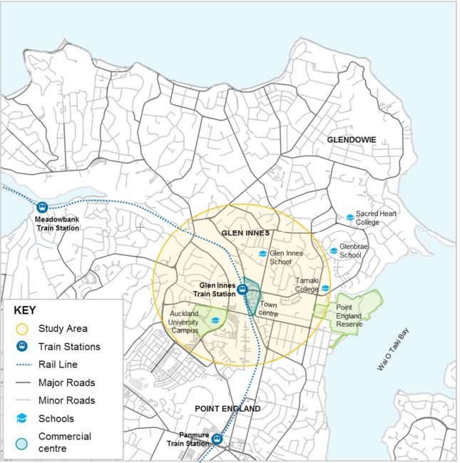
Glen Innes is a suburb located west of the Auckland CBD and borders Wai O Taiki Bay. The area is
predominantly residential; however, it also includes several schools, community facilities, businesses,
and a train station (Glen Innes Train Station). The area has recently been identified as a growth area with
intensification planned. This will include more homes, people, schools, businesses, and traffic to be
generated in the coming years. Therefore, alternative transport modes connecting the community to
and from the Auckland CBD and other key destinations has been identified as a high priority for the area.
The key objective of the project is to improve cycling connections to public transport hubs (i.e. Glen
Innes Train Station) and connect the suburbs of Glen Innes and Stonefields with the Urban Cycleway
Network through the provision of a series of separated cycleways.
Figure 1: Geographic scope of the project
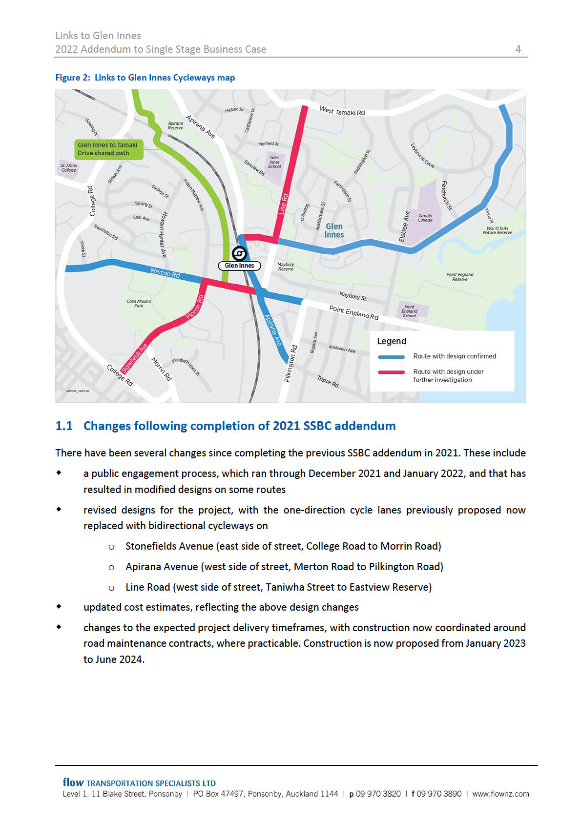
The Links to Glen Innes project proposes separated cycleways on approximately 7.3 km of Glen Innes’s
streets. The routes centre on the Glen Innes town centre and train station and connect to the terminus
of the Glen Innes to Tāmaki Drive shared path. The project also includes a comprehensive series of
pedestrian and general traffic safety improvements at intersections. Following completion of the SSBC,
the routes shown in red in Figure 2 have undergone further design refinement, which will be covered
further in later sections of this addendum.

Links to Glen Innes
2022 Addendum to Single Stage Business Case
5
2 STAKEHOLDER AND PUBLIC CONSULTATION
2.1 Overview
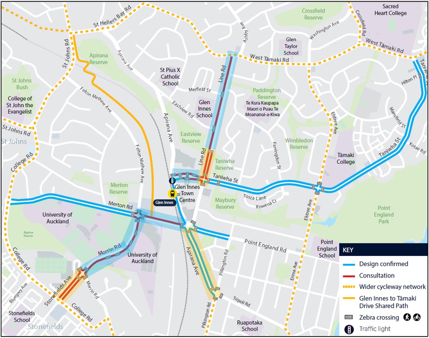
Public consultation on the Links to Glen Innes project was undertaken between December 2021 and
January 2022. A total of 243 responses were received, mainly in favour of the proposal, some of which
included suggestions of how the proposed designs could be improved.
Figure 3 shows the routes taken to public consultation in December 2021. Designs for routes shown in
blue had been confirmed previously, while designs for routes shown in red were the focus of the
consultation. The designs taken to public consultation can be viewed on the project’s webpage.1
Figure 3: Proposed Links to Glen Innes Cycleway routes
2.2 Feedback received
Following public consultation, a number of routes were confirmed to proceed to detailed design
(highlighted blue in Figure 3), while a number were identified for further investigation based on feedback
1 Auckland Transport. (2022).
Links to Glen Innes Cycleways. https://at.govt.nz/about-us/have-your-say/east-auckland-
consultations/links-to-glen-innes-cycleways/

Links to Glen Innes
2022 Addendum to Single Stage Business Case
6
from stakeholders and the community (highlighted yellow in Figure 3). One previously confirmed route
was also identified for re-evaluation (Apirana Avenue between Merton Road and Pilkington Road).
The routes confirmed to proceed to detailed design (on top of routes with previously confirmed designs)
were:
Line Road between Eastview Reserve and West Tāmaki Road - an off-road bi-directional cycleway
on the western side of Line Road
Taniwha Street off-road between Apirana Avenue and Line Road – off-road uni-directional
cycleways on either side of the road
Merton Road between Apirana Avenue and Morrin Road – an off-road bi-directional cycleway on
the northern side of the road
Morrin Road between Merton Road and Stonefields Avenue – an on-road bi-directional cycleway
on the eastern side of the road.
The matters identified for further investigation included:
the feasibility of continuing the on-road bi-directional cycleway from Morrin Road onto
Stonefields Avenue between Morrin Road and College Road instead of changing to on-road uni-
directional cycleways on either side of the road. This would provide a more continuous and
consistent facility along Morrin Road and Stonefields Avenue
the feasibility of providing an off-road bi-directional cycleway on the western side of Line Road
between Taniwha Street and Eastview Reserve (as opposed to off-road uni-directional cycleways
on either side of the road). This would result in a more continuous and consistent facility along
the length of Line Road, ensure sufficient buffer is provided between traffic and cyclists, and
balance the parking loss
potential to deliver a bi-directional on-road cycleway on the western side of Apirana Avenue
between Merton Road and Pilkington Road (instead of the proposed uni-directional cycleways).
This would result in a more continuous and consistent facility along the length of Apirana Avenue,
and allow more width in the road corridor to enable freight movements
opportunities to improve safety at driveways – particularly commercial driveways.
2.3 Outcomes from stakeholder and public consultation
Auckland Transport have adopted the changes identified through public and stakeholder consultation,
including converting the proposed uni-directional cycleways on Stonefields Avenue, Line Road and
Apirana Avenue to bi-directional facilities on one side of the road (detailed in Section 4.2).
Adjustments to driveway treatments are also proposed, including installing speed humps at busy
commercial driveways and providing clearer cyclist priority across driveways. This will ensure cyclists can
smoothly travel across driveways, and that cyclist priority over driveway traffic is evident.
Additionally, further traffic calming features on Line Road (north of Taniwha Street) and West Tamaki
Road (east of Line Road) are proposed as part of the revised plan.

Links to Glen Innes
2022 Addendum to Single Stage Business Case
9
walking and cycling networks, where multiple important routes intercept. Without the walking and
cycling improvements proposed at this intersection, the benefits of these four proposed cycle routes
would not be realised, as each would be disconnected from the other.
The roundabout is also critical to the general traffic network, as it provides access across the rail corridor
via Merton Road. The alternative rail crossings for traffic are around 1.8 km away, at St Johns Road (to
the north) and Morrin Road (south). Four bus services also pass through the roundabout, connecting
Glen Innes station and town centre to areas west, south and east.
The proposed improvements to the roundabout include raised table crossings over the Merton Road,
Line Road and Point England Road Apirana Avenue (south) legs, each linked by a network of footpaths
and a bi-directional cycleway. Collectively, these improvements
remove the barrier that this roundabout currently presents for people walking and cycling
slow traffic speeds approaching the roundabout, improving safety for all road users
link together the existing footpaths at this intersection via safe crossing facilities
connect the four proposed cycle routes that meet at this intersection via safe crossing facilities
The improvements deliver the above while maintaining two short traffic lanes on each approach to the
roundabout to minimise impacts on general traffic and bus services.
3.2 Preferred option assessment
Outcomes: Healthy and Safe People, Economic Prosperity and Inclusive Access
The desired outcomes of the project will be met for the following reasons:
Fully separated cycleways will improve safety and accessibility for people on bicycles for a range
of confidence levels and across all ages.
The cycleways provide more transport choices for the community through easily accessible
cycleway facilities.
Speed calming measures such as raised zebra crossing facilities and lane reduction (at certain
intersections) will improve safety at key intersections for both cyclists and pedestrians along the
routes.
Installation of a signalised mid-block crossing on Apirana Avenue will improve pedestrian and
cyclist safety when crossing Apirana Avenue.
The proposed cycleway routes improve the connection to the Glen Innes to Tāmaki Drive Shared
Path from Merton Road.
Provision for additional, more secure bicycle parking at the Glen Innes Train Station will encourage
more people to bike to the Glen Innes Train Station

Links to Glen Innes
2022 Addendum to Single Stage Business Case
10
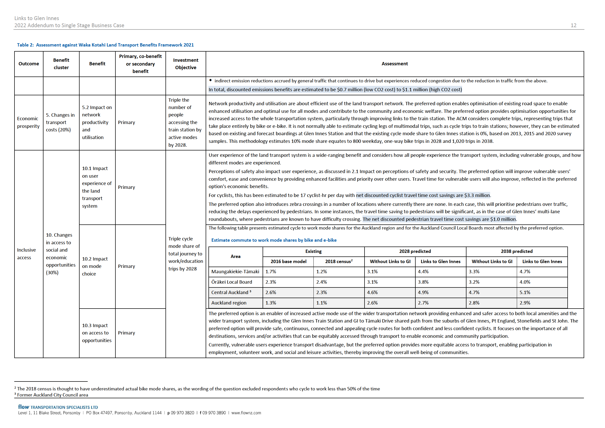
Table 2 presents an update of the project’s assessment against Waka Kotahi’s Land Transport Benefits Framework 2021. Where this assessment has changed since the 2021 Addendum, this has been highlighted.
Table 2: Assessment against Waka Kotahi Land Transport Benefits Framework 2021
Primary, co-benefit
Benefit
Investment
Outcome
Benefit
or secondary
Assessment
cluster
Objective
benefit
The preferred option provides separated cycleway facilities exclusively for cycling and micromobilty; the option provides some form of physical separation on all routes
from motor traffic, reducing and removing the likelihood of motor vehicle conflicts with vulnerable users. The cycleways offer different levels of service reflected in QoS
assessment both in terms of actual safety (i.e. in terms of crash risk) and perceived safety (i.e. in terms of people’s subjective evaluations). The preferred option also
includes improvements for all vulnerable users, including raised zebra crossing facilities, lane reduction (at certain intersections), a signalised mid-block crossing on Apirana
Avenue and overall general traffic calming.
The Waka Kotahi’s Monetised Benefits and Costs Manual (MBCM) Crash Estimation Compendium provides the following crash reduction rates that have been applied to
1.1 Impact on
the economic analysis of the preferred option:
social cost of
a 50% reduction in cycling crashes due to protected cycle lanes. The Crash Estimation Compendium provides a rate of 20% for painted cycle lanes but no further reduction for
deaths and
Primary
protected cycle lanes due to a lack of data. Recent international research provides a rate of 50%-60% for protected lanes relative to painted cycle lanes. Combining these results
serious
Reduce deaths
in a net 64% crash reduction (100% - 80% x 55%). We have applied a 50% reduction, which we consider conservative given that the project will result in almost complete
injuries
or serious
separation of cyclists from general traffic
injuries
a 20% reduction in pedestrian crashes for raised tables and 35% for kerb extensions. Both have been applied to the analysis (a net 48% reduction, i.e. 100% - 80% x 65%)
involving
a 20% reduction in general traffic crashes for traffic calming. Other relevant factors not applied include a 35% reduction for a “road diet” and an implied reduction of 40% when
people using
changing a multi-lane roundabout to a single lane roundabout (i.e. when comparing the crash prediction models for the two roundabout types in table 15). We consider the
bikes by 20% by
assessment conservative by applying only the lower factor
Healthy
1. Changes in
2028
In total, discounted safety benefits are estimated to be $2.6 million for cyclists, $6.1 million for pedestrians, and $1.8 million for general traffic. In total, this accounts for
and safe
user safety
11% of the overall project benefits.
people
(30%)
Reduce total
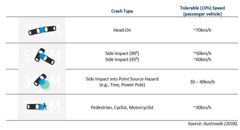
The provision of separated cycleways and other enhancements to improve safety for all vulnerable users will significantly reduce the level of risk to those users. As the speed limit
number of
on the routes is 50 km/h, the supporting treatments included in the preferred option will reduce the risk and consequence of crashes involving vulnerable users as tolerable speeds
injuries
for these types of users can be exceeded due to potential operating speeds following implementation.
involving
Safe System Kinetic Energy
cyclists and
pedestrians by
20% by 2028
1.2 Impact on Primary
a safe system
Safe Systems assessments have been carried out for all areas of the preferred option, and there is a significant reduction in SSAF scores for all routes.

Links to Glen Innes
2022 Addendum to Single Stage Business Case
11
Forecast cycling outcomes have been assessed using the Auckland Cycle Model (ACM). Below summarises the estimated trips by bike and e-bike on each of the 8 Links to
Glenn Innes routes. Two forecast scenarios are presented without the Links to Glen Innes project (but with other proposed and funded Auckland cycle infrastructure
projects) with the Links to Glenn Innes project. Forecast trips are the averages along each route. Each route is generally expected to have busier and less busy sections.
Forecast trips on Links to Glen Innes routes by bike and e-bike
2028 predicted
2038 predicted
Route
Without Links to Glen Innes
Links to Glen Innes
Without Links to Glen Innes
Links to Glen Innes
1 Line Road
40
500
40
600
2A Taniwha Street (west)
80
700
100
900
2B Taniwha Street (east)
40
300
50
400
3 Pt England Road
60
200
70
250
4A Apirana Avenue (north)
20
300
20
350
4B Apirana Avenue (south)
100
500
120
650
5 Morrin Rd and Stonefields Ave
100
400
130
500
6A Merton Road (east)
90
400
110
450
6B Merton Road (west)
20
100
20
100
3.1 Impact of
mode on
Primary
Triple cycle
The following table presents modelled cycling statistics for the Auckland region showing the increased number of trips and trip lengths created by the preferred option.
3. Changes in
physical and
volumes in
human health mental health
Modelled cycle network statistics
dense activity
(20%)
centres by 2028
“Existing”
2028 predicted
2038 predicted
2016 base model
Without Links to Glen Innes
Links to Glen Innes
Without Links to Glen Innes
Links to Glen Innes
Predicted daily cycle
18,600
44,300
45,800
53,400
55,300
trips
(+1,500)
(+1,900)
Predicted daily cycle-km
98,000
265,000
270,000
332,000
338,000
(+5,000)
(+6,000)
Average cycle trip
5.3 km
6.0 km
5.9 km
6.2 km
6.1 km
length
Health benefits for cyclists
Health benefits are also gained from additional cycling activity that the preferred option provides. Cyclist health benefits have been calculated for the full length of each
new cyclist trip. Discounted over the 40-year evaluation period of the project, this benefit stream equates to $42.5 million
Health benefits for pedestrians and wheeled pedestrians
The MBCM also calculates health benefits for new pedestrian trips as the preferred option will improve pedestrian connectivity across busy multi-lane roundabouts that
currently lack pedestrian crossing facilities. Addressing these crossings will reduce barriers to walking trips and encourage more people within Glen Innes to walk. These
benefits have been estimated based on the preferred option resulting in a 20% increase in these pedestrian trips; discounted pedestrian health benefits are estimated to
be $20.9 million in total.
3.2 Impact of
Emissions reductions associated with the preferred option come from two sources
air emissions
Primary
direct emission reductions, where a private car driver chooses not to drive but to walk or cycle instead
on health

Links to Glen Innes
2022 Addendum to Single Stage Business Case
13
Table 2: Assessment against Waka Kotahi Land Transport Benefits Framework 2021
Primary, co-benefit
Benefit
Investment
Outcome
Benefit
or secondary
Assessment
cluster
Objective
benefit
10.4 Impact
The preferred option provides improved community cohesion to enable and maintain the normal functions of a community by improving facilities for vulnerable uses and
on
remedying the impact on system vulnerabilities for individuals and the overall community caused by heavy volumes of general traffic. In addition, the preferred option
Secondary Benefit
community
improves users' safety and perceptions of safety and accessibility through enhanced crossing facilities and connectivity locally and to the wider transport system.
cohesion

Links to Glen Innes
2022 Addendum to Single Stage Business Case
15
However, the revised construction timeframes have marginally affected the discounting of the project’s
benefits. Therefore, our updated assessment also updates the time-zero to July 2022 and applies current
MBCM update factors.
4.3 Benefit Streams
The economic evaluation has been updated in accordance with Waka Kotahi’s MBCM. As a result,
revised project benefits are presented below in Table 4, reflecting the updated project construction
timeframes and an updated time-zero of July 2022.
Table 4: Discounted economic benefits (Net Present Value – NPV)
Economic input
Links to GI project
Health benefits
$42.5 m
Cycling benefits Perceived travel time benefits
$3.3 m
Safety benefits
$2.6 m
Health benefits
$20.9 m
Pedestrian
Travel time benefits
$1.0 m
benefits
Safety benefits
$6.2 m
General traffic reduction benefits
$22.1 m
General traffic
General traffic dis-benefits
-$25.4 m
benefits
Safety benefits
$1.8 m
Emissions reduction benefits 4
$0.7 – $1.1 m
Total discounted benefits
$75.8 – $76.2 m
We note that the estimated project benefits of $75.8-$76.2 million are only marginally different from
the previous (2021 addendum) benefits of $71.7-$72.1 million. The difference results from the slightly
changed construction timeframes, updated time-zero, and revised MBCM update factors.
We also note that the estimated project benefits continue to include $25 million of travel time dis-
benefits for general traffic. Most of this is a result of the reduced traffic capacity at the Merton
Road/Morrin Road roundabout. As per the 2021 addendum, we consider this calculation to be
conservative: actual travel time dis-benefits will be smaller if some car users respond to the project by
changing their mode, their route, their time of travel, or their destination.
4.4 Project Costs
Project costs have been supplied by Auckland Transport and include expected (P50) implementation
costs of $32.5 million (including Auckland Transport’s admin costs). This includes
$6.6 million for Separable Portion 1 (Taniwha Street east)
4 Waka Kotahi require emissions benefits to be calculated using a low and high carbon cost range.

Links to Glen Innes
2022 Addendum to Single Stage Business Case
17
Table 6: Project BCR sensitivity testing
Sensitivity
Input
Assumption
Sensitivity test
test BCR
E-scooters are assumed to account for Low e-scooter proportion
2.5
20% of pedestrian trips by 2028, 40%
(10% 2028, 20% 2038)
by 2038.
High e-scooter proportion
2.2
(30% 2028, 60% 2038)
E-scooters assumed to generate the
E-scooter rides accrue the same
2.6
same health benefit per km as e-bikes
health benefits per km as walkers
Health
Walking and cycling health benefits
50% cap (50% of New Zealand
2.0
benefits
are capped by factoring by 60% (40%
population meets MoH guidelines)
of Auckland population already meets
No cap
3.6
Ministry of Health exercise guidelines)
20% increase in pedestrian trips
Low increase: 10%
2.0
assumed following project
High increase: 30%
2.6
General
Economic evaluation applies a flat
Assume a $3/km benefit rate in
3.0
traffic
$1.97/km benefit rate for peak period
2028, $4/km in 2038.
benefits
car trips removed from the MBCM.
This rate does not change over time.
Other central Auckland projects have
developed project specific rates, using
traffic models that reflect local traffic
conditions. These rates can be as high
as $5/km in 2028 and $7/km in 2038.
Traffic benefits calculated for weekday Include interpeak period traffic
2.5
commuter periods only
benefits
Congestion
Cycle demand modelling assumes no
Sensitivity test higher cycle
2.8
charging and
future changes in generalised costs of
demand (+20%), reflecting higher
other changes travel by public transport or car. In
generalised cost of travel by car
in generalised practice, generalised costs may
and public transport
costs
increase due to changes such as
congestion charging, increased
Sensitivity test lower cycle demand
1.9
parking and public transport costs, or
(-20%), reflecting lower generalised
increased fuel costs. In these cases,
cost of travel by car and public
cycle demands would be expected to
transport
increase. Conversely, generalised
costs may decrease due to
improvements in public transport
infrastructure. In this instance, cycle
demands may reduce.

Links to Glen Innes
2022 Addendum to Single Stage Business Case
18
Table 6: Project BCR sensitivity testing
Sensitivity
Input
Assumption
Sensitivity test
test BCR
Cycle
2028 forecasts assume the completion Tested through +20% cycle
n/a
infrastructure of cycle projects with RLTP funding.
demand test above
2038 forecasts assume no further
background investment in cycling.
Future, connecting cycle infrastructure
projects would likely increase cycle
demand on the project.
Pedestrian
Pedestrian demands based on count
20% higher pedestrian demands
2.5
demands
data from 2016 survey data
20% lower pedestrian demands
2.2
Pedestrian growth: 5% annual growth
Low growth in pedestrian
2.1
assumed
demands: 3%, matching forecast
population growth
High growth in pedestrian
2.6
demands: 8%, matching forecast GI
station patronage growth
Trips to GI
10% cycle mode share estimated with
Low mode share: 5%
2.2
station
project
High mode share: 20%
2.6
20% of the above cycle-train trips are
Low proportion of diverted car
2.2
assumed to be diverted car trips (i.e.
trips: 10%
Glen Innes to CBD or similar)
High proportion of diverted car
2.5
trips: 30%
General
Calculated for travel time, congestion
Some vehicle trips change route
2.7
traffic dis-
and vehicle operating costs during
/time /mode: 50% dis-benefits
benefits
peak periods at roundabouts where
More vehicle trips change route
3.1
traffic capacity is being reduced. Fixed
/time /mode: 0% dis-benefits
demands assumed.
Calculated for commuter peaks,
Omit interpeak and weekend peak
2.5
weekday interpeak and weekend peak traffic effects, consistent with the
periods.
calculation of general traffic
decongestion benefits
Costs
Calculated using expected (P50) costs
Undiscounted P95 construction
2.1
costs of $31.0 million

Links to Glen Innes
2022 Addendum to Single Stage Business Case
19
4.7 Investment assessment framework rating
The 2021 addendum assessed the project against Waka Kotahi’s Investment Prioritisation Method for
the 2021–24 National Land Transport Programme. It found that the project had a Priority Order of 6 (1
being the highest, 12 being the lowest), based on a
High GPS alignment
Medium scheduling rating
Low efficiency, with a BCR at the time of 2.1
The ratings for GPS Alignment and Scheduling remain unchanged. However, the BCR is now 2.3 due to
cost savings. The new BCR, however, remains within the 1 to 3 range for a Low Efficiency rating. As a
result, the project’s Priority Order remains unchanged at 6.
4.8 Investment performance measures
The project’s investment performance measures remain unchanged relative to the 2021 Addendum.