


RESTING RAIL 0.35m BACK
20MPa CONCRETE. FINISH TO BE
FROM EDGE OF ISLAND
AGREED WITH COUNCIL ENGINEER
20MPa CONCRETE. FINISH TO BE
KERB PAINTED WITH
N
1.8m TACTILE PAVERS
AGREED WITH COUNCIL ENGINEER
REFLECTORISED WHITE PAINT
KERB PAINTED WITH
0.6m RADIUS
REFLECTORISED WHITE PAINT
125
75
PROPOSED 2.0m WIDE PRAM CROSSING
75
AS PER KCDC STANDARD DRAWINGS
30
105
0.6m RADIUS
RESTING RAIL 0.35m BACK
2.5m GAP IN
FROM EDGE OF ISLAND
R10 BAR @750 CRS
PEDESTRIAN ISLAND
RG17 OR RG17.1 SIGN ON
R10 BAR
50mm LONG
RG17 OR RG17.1 SIGN ON 60mm
200
60mm POWDER COATED
ENSURE EXISTING STORMWATER
PROPOSED NO STOPPING MARKINGS EACH
POWDER COATED WHITE
WHITE ALUMINIUM POST
SUMPS ARE AVOIDED
SIDE OF PRAM CROSSING, AS PER NZTA
ALUMINIUM POST WITH SOCKET
WITH SOCKET
PEDESTRIAN PLANNING AND DESIGN GUIDE
MOUNTABLE KERB
PEDESTRIAN REFUGE DETAIL
NOT TO SCALE
(FOR ISLANDS ONLY)
NOT TO SCALE
NOTE:
1.40
1.06m
1.
LENGTH OF EACH ISLAND 2x THE WIDTH OF ISLAND.
1.20
MEASUREMENT TO BE AGREED WITH COUNCIL ENGINEER ON
60mm POWDER COATED YELLOW
1.00m
SITE.
GALVANISED STEEL PIPE-3.2mm WALL
15.00
2.00
15.00
2.
EXISTING PAVEMENT SURFACE SHALL BE COATED WITH
THICKNESS
APPROVED BONDING AGENT PRIOR TO PLACING ANY MORTAR
REFLECTORISED TAPE
BEDDING.
LOWER BAR
1.0m
3.
SURFACE OF THE ISLAND TO HAVE A 3% CROSSFALL OR MAX
50mm
RISE TO CENTRE OF 150mm.
100mm CLEARANCE
4.
A MINIMUM CLEARANCE OF 300mm BETWEEN KERB FACE AND
FROM GROUND LEVEL
LANE EDGE AND BETWEEN EDGE OF ANY SIGNS AND KERB
KAPITI ROAD
PROPOSED 2.4m WIDE PEDESTRIAN REFUGE
FACES.
3.50
0.30
AS PER KCDC STANDARD DRAWING NO.
60mm ALUMINIUM SOCKET
5.
INSTALL TACTILE PAVERS TO LTNZ RTS14 GUIDELINE WHEN
4.80
2.50
KCDC-ED-011 R11
IMBEDDED INTO 400mm CONCRETE
REQUIRED. REFER TO RELEVANT NZTA, MOTSAM, TCD, RSMA AND
HOLD RAIL DETAIL
E & P/24 SPECIFICATIONS.
NOT TO SCALE
6.
MOUNTABLE NIB KERB OR BLOCKS.
7.
RESTING RAILS OFFSET AT LEAST 350mm FROM THE KERB FACE
3.00
2.40
AT THE EDGE OF THE ADJACENT TRAFFIC LANE(S).
8.
FINAL DETAILS TO BE AGREED WITH COUNCIL ENGINEER ON SITE.
LANDING 1.33m MIN FROM TOP
0.30
OF RAMP TO ANY OBSTRUCTION
3.50
BERM
2.00
BERM
SAWCUT
SAWCUT
CONCRETE FOOTPATH
2.50
WITH BLACK OXIDE
1:12
SAWCUT
1:12
1:12
GRADE
SAWCUT
GRADE
GRADE
BERM
BERM
CONCRETE FOOTPATH
WITH BLACK OXIDE
EXISTING NO STOPPING
0.6m
2.0m
0.6m
KERB AND CHANNEL
0.6m
2.0m
0.6m
KERB AND CHANNEL
MARKINGS TO REMAIN
PROPOSED 2.0m WIDE PRAM
CROSSING AS PER KCDC
PRAM CROSSING LOCATION GENERALLY LOCATED
STANDARD DRAWINGS
TO CONNECT WITH PATH FROM WETLANDS.
EDGE OF KERB AND BERM SHAPED
100mm CONCRETE FOOTPATH AT
TACTILE PAVERS
EXACT LOCATION OF PRAM CROSSING TO BE
TO MATCH TOP OF PRAM LEVEL
20MPa WITH BLACK OXIDE
100mm CONCRETE FOOTPATH AT 20MPa
CONFIRMED ON SITE WITH COUNCIL ENGINEER
ADDITIVE AT A RATE OF 2KG/M3
0.30m
0.30m
WITH BLACK OXIDE ADDITIVE AT A RATE OF
PRIOR TO CONSTRUCTION STARTING.
TACTILE PAVERS
NO LIP
NO LIP
2KG/M3
BERM
BERM
EXISTING FOOTPATH IN WETLANDS
100mm COMPACTED
TE HUARAHI RAUPO
1.5m 1:12 GRADE
100mm COMPACTED BASECOURSE AP40.
BASECOURSE AP40.
1.5m 1:12 GRADE
(WETLANDS)
CLEGG TESTED >25
CLEGG TESTED >25
PLAN
SCALE 1:100
PRAM CROSSING WITH BERM
PRAM CROSSING ADJACENT
ADJACENT TO KERB DETAIL
TO KERB DETAIL
NOT TO SCALE
NOT TO SCALE
NAME
DATE
STATUS:
KAPITI COAST DISTRICT COUNCIL
SURVEYED
-
-
FOR CONSTRUCTION
DESIGNED
R.GRUITERS
30.10.19
MINOR SAFETY PROJECT
0
1
2
3
4
5m
DATE:
SCALE AT A1:
10.12.2019
AS SHOWN
DRAWN
R.GRUITERS
30.10.19
SCALE 1:100 AT ORIGINAL SIZE
KAPITI ROAD PEDESTRIAN REFUGE
DRAWING NO.
REV
1
ISSUED FOR CONSTRUCTION
RG
SG
RG
10.12.19
REVIEWED
S.GREEN
31.10.19
REV
REVISION DESCRIPTION
OVERALL LAYOUT PLAN & CONSTRUCTION DETAILS
17-088-03-C001
1
DRAWN
CHECKED APPROVED
DATE
APPROVED
IS-12-670
Chairperson and Committee Members PARAPARAUMU/RAUMATI COMMUNITY BOARD
9 OCTOBER 2012
Meeting Status:
Public
Purpose of Report: For Decision
NO PARKING LINES ON KĀPITI ROAD
PURPOSE OF REPORT
1
This report seeks Council approval to install broken yellow lines from the
entrance of Seven Oaks in the 70k area towards Hurley Road, and broken yellow
lines on Kāpiti Road from the complex to Cedar Drive.
SIGNIFICANCE OF DECISION
2
The recommendations in this report do not trigger the Council’s significance
policy.
BACKGROUND
3
Several requests have come from the Kāpiti Retirement Trust wanting no parking
lines on Kāpiti Road as there are concerns with the visibility for cars exiting the
Seven Oaks complex onto Kāpiti Road due to vehicles parked right up to the
entrance-way to the village.
4
This area would include the Kea Crossing which was previously installed without
the required no stopping lines.
CONSIDERATIONS
Issues
5
The solution to the problem would be to install give way signage and associated
road markings at both sites in line with Attachment 1
Financial Considerations
6
There are no financial considerations, as the cost of the proposed works is in the
order of $5,000 and can be accommodated from the 2012/2013 Minor Works
budget.
Legal Considerations
7
There are no legal considerations
Delegation
8
The Community Board has “authority” to approve or reject officer
recommendations relating to all traffic control and signage matters, in relation to
Page 1 of 2
IS-12-670
existing local roads within the community board’s area, except for changes to
speed restrictions on local roads. (The latter power has been delegated to the
Regulatory Management Committee).
Consultation
9
The police have been consulted with and are supportive of this solution.
Publicity Considerations
10 The public will be notified prior to works commencing on site and again once the
improvements are complete through a press release.
RECOMMENDATIONS
11 That the Paraparaumu/Raumati Community Board approves the installation of
broken yellow lines from the entrance of Seven Oaks in the 70k area towards
Hurley Road, and broken yellow lines on Kāpiti Road from the complex to
Cedar Drive.
Report prepared by:
Approved for submission by:
Jane Pearson
Sean Mallon
TRANSPORT SAFETY
GROUP MANAGER
COORDINATOR
INFRASTRUCTURE SERVICES
ATTACHMENT 1: proposed broken yellow lines area
Page 2 of 2
IS-18-426
Chairperson and Community Board Members
PARAPARAUMU/RAUMATI COMMUNITY BOARD
13 FEBRUARY 2018
Meeting Status:
Public
Purpose of Report: For Information and decision
BROKEN YELLOW LINES ON KĀPITI ROAD
PURPOSE OF REPORT
1
To inform the Community Board of the decision to install broken yellow lines on the
north side of Kāpiti Road between Larch Grove and Warrimoo Street.
2
To obtain approval from the Community Board to extend the existing broken yellow
lines on the north side of Kāpiti Road between Seven Oaks and Cedar Drive to cover
the whole length of this section of Kāpiti Road.
DELEGATION
3
Section D of the Governance Structure and Delegations 2016-2019 Triennium
provide the Community Board with the
“…Authority to approve or reject officer recommendations relating to traffic
control and signage matters for existing local roads, except those matters that
involve significant safety issues. Community Boards will be consulted about
these matters but final delegation will rest with Council officers”.
4
The matter referred to under 1. is considered a significant safety issue and is
therefore presented for information. The matter referred to under 2. is presented for
decision-making.
BACKGROUND
5
The section of Kāpiti Road between Larch Grove and Warrimoo Street was already
identified in 2014 as posing a safety issue for cyclists when cars are parked on the
on-road cycle lane. Along the south side of this section of Kāpiti Road with the
exception of one 8 metre section broken yellow lines (BYLs) were installed. On the
north side no BYLs were installed after consultation with residents.
6
The installation of BYLs on both sides for the full length of this section has now been
reconsidered following continued feedback from Kāpiti’s cycling groups.
7
Requests also have been received from residents to extend the existing BYLs along
Kāpiti Road between Seven Oaks and Cedar Drive.
ISSUES AND OPTIONS
Issues
8
Kāpiti Road between Warrimoo Street and Larch Grove
The Council has received continued requests for the installation of BYLs on both
sides of Kāpiti Road on this section from cyclist advocacy groups. In 2014 BYLs were
installed on the southern side only with the exception of 8 metres outside the
property at 45 Kāpiti Road. This was the result of consultation with residents and
#3422280
Page 1 of 3
IS-18-426
receiving feedback from three residents along this section that were opposed to the
BYLs for various reasons.
9
If cars are parked on the cycle lane this means that cyclists have to swerve around
them, into the live traffic lane. The latest traffic count on Kāpiti Road is 22,000
vehicles per day and it is by far Kāpiti’s busiest arterial road. This puts cyclists at a
high risk of being involved in an accident. For that reason, on large parts of Kāpiti
Road, BYLs have already been installed.
10 A comparison of crash statistics shows that Kāpiti has the second highest crash risk
on arterial roads in comparison to the peer group (Upper Hutt, Porirua, Nelson,
Napier, Palmerston North and Invercargill). Kāpiti Coast has also been identified by
New Zealand Transport Association (NZTA) in the Communities at Risk Register as
having the second highest personal risk for cyclist crashes of all local authorities in
New Zealand.
11 Council wants to deliver roads that are safe for all its users and wants to encourage
and promote the use of active transport modes. Taking the above into account, the
current situation is considered to pose a high safety risk for cyclists and the decision
was made to install BYLs along the northern side between Warrimoo Street and
Larch Grove and on the 8 metre section on the southern side that previously was not
included. A plan of the extended parking restrictions is included as Appendix 1 of this
report.
12 Kāpiti Road between Seven Oaks and Cedar Drive
BYLs were installed at the intersection of Kāpiti Road and Cedar Drive in March 2017
to improve visibility for vehicles turning out of Cedar Drive onto Kāpiti Road. A
section of approximately 25 metres was left without BYLs to allow for some car
parking. Having on-street car parking on this section of Kāpiti Road is seen as a
passive traffic calming method, it creates “side friction” and helps to reinforce that it is
a 50kmh road. In recent months service requests have been received requesting the
extension of the BYLs to Cedar Drive to prevent any car parking and improve
visibility further.
Options
13 Kāpiti Road between Seven Oaks and Cedar Drive has been looked at several times
and by different members of the Roading Team, and the visibility in each direction
has been within guidelines and is not considered an issue. The on-road cycle lane
also places oncoming vehicles a further 1.5 metres out from any parked cars
improving visibility. Visiting the site after each initial service request proved fruitless
because there were few if any cars parked there but in recent weeks the cars for sale
numbers have tripled and now extend from Magrath Avenue through to Cedar Drive.
From a road safety perspective, the current BYLs allow for appropriate visibility but
based on the service requests residents are having a different experience and do not
feel safe pulling out of Cedar Drive. Therefore it is recommended that the BYLs are
extended and fill in the gap between Lodge Drive and Cedar Drive.
#3422280
Page 2 of 3
IS-18-426
CONSIDERATIONS
Legal considerations
14 There are no legal considerations other than ensuring any new road-markings are
installed in accordance with NZTA Guidelines and New Zealand Traffic Regulations.
Financial considerations
15 The cost of line marking the new broken yellow lines can be accommodated in the
2017/2018 road maintenance budget.
SIGNIFICANCE AND ENGAGEMENT
Significance policy
16 This matter has a low level of significance under Council policy.
Consultation already undertaken
17 Previous consultation was undertaken in February 2014 with Kāpiti Road residents
between Moana Road and Larch Grove resulting in parking restrictions only being
implemented on the south side of Kapiti Road between Warrimoo Street and Moana
Road. Safety concerns for the greater community now outweigh the need of some
residents to retain on-street parking on this section of Kapiti Road. Residents
affected by the new parking restrictions were informed of the changes by letters sent
out on 17 January 2018. To date, no feedback on the letter has been received.
18 For the section of Kāpiti Road between Lodge Drive and Cedar Drive, there are no
residential properties fronting or taking access from Kāpiti Road and on-street
parking is not required. Residential properties in this area are all part of the Seven
Oaks retirement village and take access from their internal roads. We do not
consider them to be affected by any parking restrictions and have therefore not
consulted them.
RECOMMENDATIONS
19 That the Paraparaumu/Raumati Community Board approves:
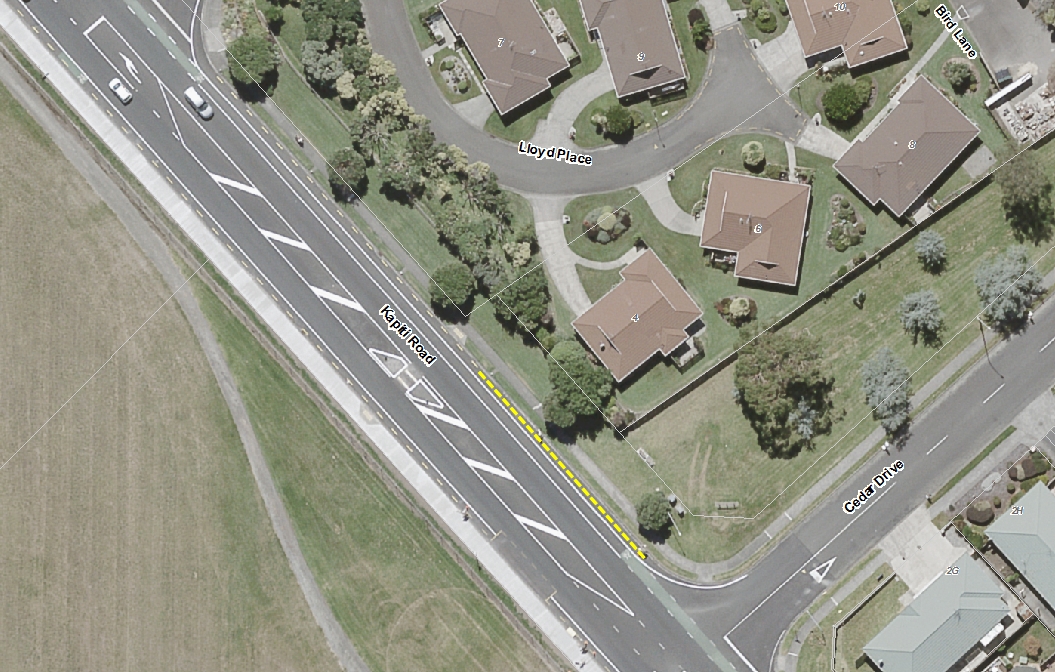
20 Installation of 30 metres of broken yellow lines from a point 60 metres east of Lodge
Drive to a point 10 metres west of Cedar Drive on Kāpiti Road as shown in Appendix
2 of report IS-18-426.
Report prepared by Approved for submission Approved for submission
Gary Adams
Max Pedersen
Sean Mallon
Traffic Engineer
Group Manager
Group Manager
Community Services
Infrastructure Services
ATTACHMENTS
Appendix 1 Parking Restrictions 45 and 46-54 Kāpiti Road
Appendix 2 Parking Restrictions on Kāpiti Road at the corner of Cedar Drive
#3422280
Page 3 of 3


Kapiti Coast District Council accepts no responsibility for incomplete or
SCALE 1: 500
@A4
App1 Parking Restrictions 45, 46-54 Kapiti Rd
inaccurate information contained on this map. Use of this website is subject
to, and constitutes acceptance of the conditions set out in our disclaimer.
This publication is copyright reserved by the Kapiti Coast District Council.
Date Printed:
Cadastral and Topographic information is derived from Land Information
30-January-2018
New Zealand, CROWN COPYRIGHT RESERVED.


Kapiti Coast District Council accepts no responsibility for incomplete or
SCALE 1: 500
@A4
App2 Parking Restrictions Kapiti Rd nr Cedar Dr
inaccurate information contained on this map. Use of this website is subject
to, and constitutes acceptance of the conditions set out in our disclaimer.
This publication is copyright reserved by the Kapiti Coast District Council.
Date Printed:
Cadastral and Topographic information is derived from Land Information
30-January-2018
New Zealand, CROWN COPYRIGHT RESERVED.

Document Outline