
 Technical Memorandum
July 22, 2022
To
Technical Memorandum
July 22, 2022
To
Tom Parsons, CCC
Contact No.
Copy to
Andrew Watt
Email
[email address]
From
Andrew Malden
Project No.
12509119 Rev 1 (Status Code S4)
Project Name
Edgeware Village Full Height Kerb Assessment
Subject
Assessment Findings
1.
Introduction
The shops behind the south side kerb of Edgeware Road between Sherborne Street and Colombo Street in
Edgeware, have a history of flooding. The existing kerb is a low height kerb and is not to current
Christchurch City Council (CCC) design standards. CCC have indicated that the community have raised
concerns that the current kerb does not have adequate surface water capacity. A drainage assessment was
undertaken by CCC staff which highlighted that:
–
The flooding is driven by St Albans Creek water level during flooding events preventing clear outfall
from the network to the creek, which surcharges the existing gravity stormwater drainage system. This
surcharging leaves nowhere for the surface runoff to drain to and in turn floods the area.
–
Provided that the above point is addressed and that there is clear outfall to St Albans Creek for the
piped flow, the existing kerb does have capacity to meet the stormwater design requirements.
The objective of this memo is to conduct a high level investigation into the feasibility and merits of
construction of a full height kerb on the south side of Edgeware Road between Sherborne Street and
Colombo Street. CCC want to understand the constraints, benefits, risks and issues associated with the
work to inform an options report to Council.
This investigation does not take into account the CCC Edgeware Village Masterplan from December 2013
(https://ccc.govt.nz/assets/Documents/The-Council/Plans-Strategies-Policies-Bylaws/Plans/suburban-
plans/EdgewareVillageFinalMasterPlan.pdf). Preparation of this masterplan has been paused at the
request of the Community Board, but initial drafts indicated that the kerb may not be on the same alignment
as the existing. This work is out of scope for the purpose of this investigation. Although it should be noted
that to achieve the outcome of the masterplan, the existing road would likely have to be rebuilt.
2.
Roading Assessment
2.1
Existing Site
The current road speed through this section has recently been reduced to 30 km/h as part of the
Downstream Effects Management Plan (DEMP) project.
This Technical Memorandum is provided as an interim output under our agreement with Christchurch City Council. It is provided to foster discussion in relation to
technical matters associated with the project and should not be relied upon in any way.
The Power of Commitment
12509119 Rev 1 (Status Code S4) 1
The existing kerb on Edgeware Road between Sherborne Street and Colombo Street has a lower height
than the current CCC standard detailed in CSS SD601 Part 6. The current standard is for a 130 mm high
kerb, whereas the existing kerb through this section is only approximately 40 mm high.
The condition of the kerb is poor, with multiple large cracks along the entire length. The kerb is not planned
for replacement in the near future. There have been recent upgrades to the kerb on either end, both on
Sherborne Street and Colombo Street, as part of the DEMP and Major Cycle Route Program (MCR). The
length of deficient kerb between these two sections is 94 m, which is the length of kerb replacement
considered in this investigation.
The existing road profile has very flat crossfall to the north side (less than 2%) and is very steep to the
south (up to 5.3%). The north side existing kerb fender levels are much higher compared to the existing
kerb fender levels on the south side of the road by up to 288 mm. Refer to Appendix B for a full table of all
the existing kerb fender and centreline heights and crossfalls.
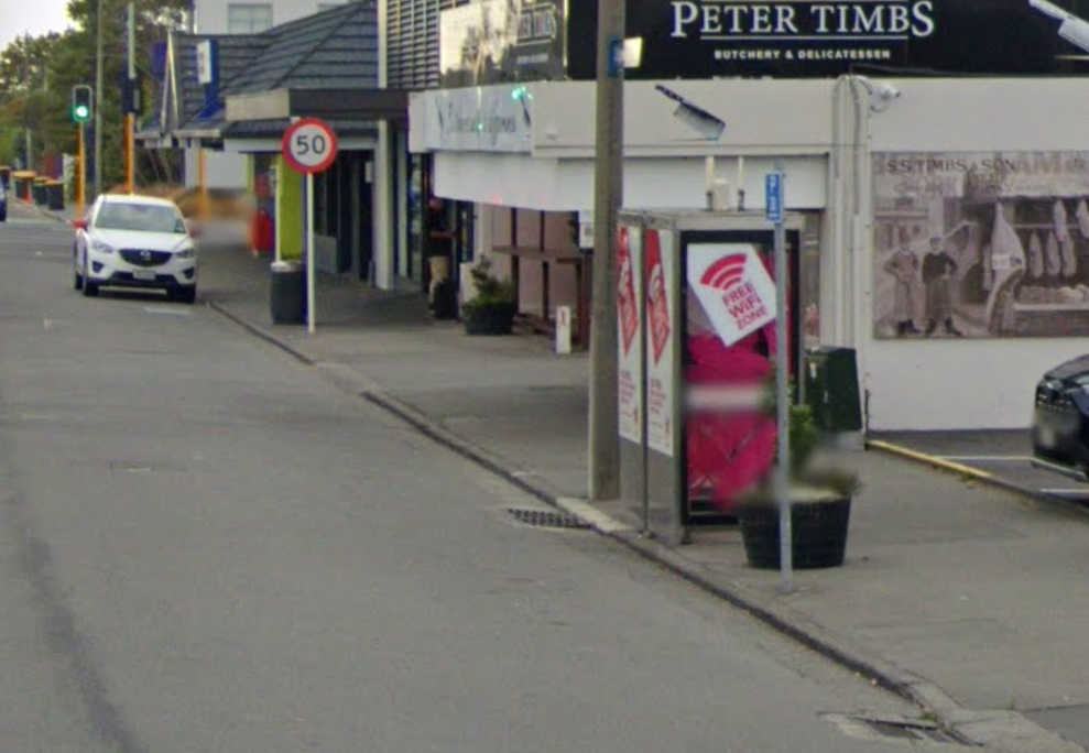
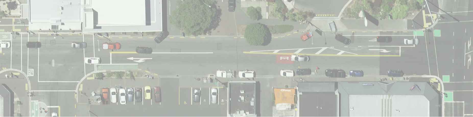
A photograph of the south side of Edgeware Road between Sherborne Street and Colombo Street is shown
in Figure 1.
Figure 1
South side of Edgeware Road between Sherborne Street and Colombo Street
2.2
Replacement with Full Height Kerb on Southern Side
If we replace the existing low height kerb with new CCC standard full height kerb, matching the existing
kerb lip levels (with the back of kerb level higher than existing) as shown in Figure 2, we find that:
–
There would be minimal carriageway works required along the shoulder
–
This approach works for the first 35 m from the tie in point near Colombo Street to approximately the
start of the Peter Timbs Butcher building.
–
From this point to the end of the deficient kerb at Sherborne Street, the new path crossfall level ranges
between 0.1% to 0.5% and would be flatter than allowed by the design standard. The CCC IDS Part
8.15.2 states a minimum of 1.2% and an optimum 2% is required. A maximum of 3% is generally used,
This Technical Memorandum is provided as an interim output under our agreement with Christchurch City Council. It is provided to foster discussion in relation to
technical matters associated with the project and should not be relied upon in any way.
12509119 Rev 1 (Status Code S4) 2
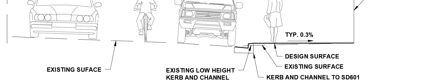
with anything over this agreed with CCC. An acceptable crossfall allows for the surface runoff of water
into the kerb and channel and prevents water ponding and freezing over during winter, causing a slip
hazard, while still providing a stable surface for pedestrians. The current existing crossfalls are at a
nominal 3%.
Figure 2
Edgeware Road Typical section of the South side existing low-profile kerb replaced with full-height kerb at
existing fender level
As this first scenario does not meet the design requirements, we looked at replacing the existing low height
kerb with new CCC standard full height kerb, but this time matching the existing back of kerb levels, and we
found that:
–
Minimal work is required to the footpath, leaving the existing footpath at 3% crossfall
–
The shoulder tie-in from the kerb lip to the existing road surface becomes too steep, in the range of
6.5% to 9.5%. The shoulder through this section is used for on-street parking, which CCC IDS Part
8.13.4 states should not exceed 6%. Anything steeper than 6% could cause high sided vehicles to lean
too far and clash with the shop awnings, as well as making it dangerous for people getting into and out
of their vehicles.
–
The driveways become too steep and would be unusable, as the change in grade can cause vehicles
to bottom out. It is generally accepted that a maximum of 12% change of grade is used when
designing driveways.
As detailed above, neither of these approaches would be acceptable, and further work would be required to
achieve an outcome that meets all accepted design criteria.
2.3
Proposed Full Height Kerb Design
Due to the deficiencies of replacing the existing low height kerb with full height kerb described in Section
2.2, the following work is required to mitigate these deficiencies and achieve construction of full-height kerb
outside Edgeware Village:
–
Lower the existing road crown over a 102 m length by up to 130 mm
–
Lower the kerbs on both the south and north side of Edgeware Road
–
Construct new footpaths on both sides of the road
This work is detailed in the provided sketches in Appendix A.
2.3.1
Edgeware Road Cross Section
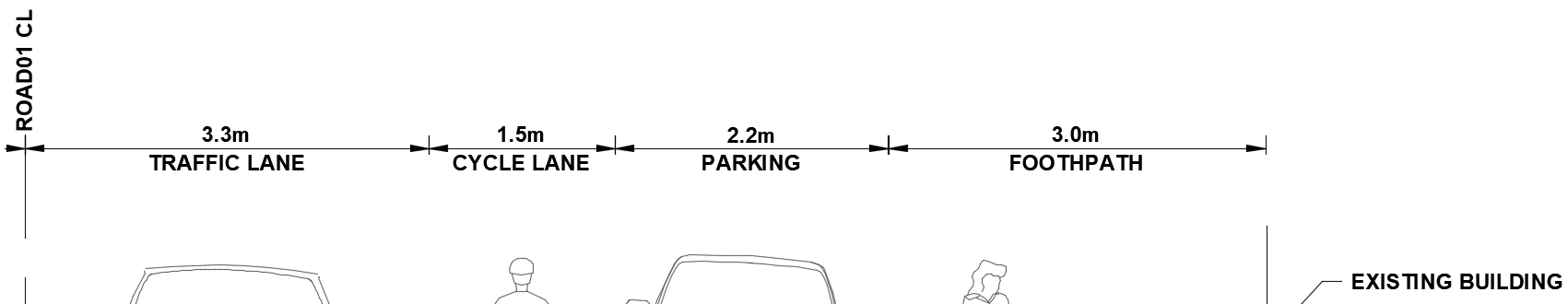
The proposed cross section has been kept the same as the existing cross section which consists of:
–
3 m footpaths each side
–
1.5 m on-road cycle lane both sides
This Technical Memorandum is provided as an interim output under our agreement with Christchurch City Council. It is provided to foster discussion in relation to
technical matters associated with the project and should not be relied upon in any way.
12509119 Rev 1 (Status Code S4) 3
–
2.2 m on-street parking on the south side
–
Single nominal 3.2 m (varies) westbound traffic lane
–
Single nominal 3.2 m (varies) eastbound traffic lane
–
Single exclusive right turn lane at the Sherborne Street and Edgeware Road signalised intersection
The actual sections shown in Appendix A show footpath crossfalls ranging from 2% to 4%. With fine tuning of
the design during a more detailed design process, consistent grades of 2% to 3% would be achievable.
2.3.2
Proposed Kerb and Road Longitudinal Grades
The proposed north side kerb and the south side kerb meet minimum longitudinal grade requirements of
1:500.
The existing stormwater system is intended to be used with this design. All sags are in the same locations,
and require the existing sumps to be lowered, taking into consideration the cover requirements for any
stormwater pipes which may be required to be lowered. The use of the existing stormwater system would be
dependent on further work being carried out on flood mitigation to the existing gravity drainage network
through here.
To tie the design into the existing surface, there will be an impact to the northbound lanes through the
intersection of Edgeware Road and Sherborne Street. The lowered Edgeware Road crown will need to be
tied 6 m into Sherborne Street, so work will impact the usage of this intersection.
2.3.3
Impacts and Risks of the Proposed Design
The impacts of this work are:
–
Lowered road surface results in less cover to existing services. This may result in extensive service
lowering, protection or relocations. Services which exist through this section which would be impacted
include:
•
Stormwater
•
Water Supply
•
Sewer
•
Power
•
Fibre
•
Gas
•
2x Public Telephone booths
•
Streetlighting
•
Various roadside amenities such as rubbish bins, planter boxes and street sign
Risks associated with the proposed works include:
–
Unknown existing pavement condition which lowering of the road could lead to extensive pavement
reconstruction
–
If the existing DN825 stormwater pipe is too high and does not have adequate cover, this could lead to
an expensive and time consuming stormwater network redesign
–
Discovery of contaminates, in particular coal tar, which is prevalent throughout Christchurch and
requires expensive dumping fees and impacts construction time
–
Extensive excavation may reveal archaeological objects which can impact the construction programme
–
Extensive traffic management would be required causing delays to the road network
–
Disruptions to the local businesses on both side of Edgeware Road, causing possible temporary loss
of business
–
Service strikes causing disruptions to local businesses and lengthy repairs
This Technical Memorandum is provided as an interim output under our agreement with Christchurch City Council. It is provided to foster discussion in relation to
technical matters associated with the project and should not be relied upon in any way.
12509119 Rev 1 (Status Code S4) 4
–
Discovery of historical tram tracks can add a significant cost to the overall project cost.
2.3.4
Benefits of the Proposed Design
The benefits from lowering the road crown on Edgeware Road and installing new kerb on both sides of the
road are:
–
Increasing the capacity of the major secondary drainage system. This is only beneficial if further flood
mitigation works are conducted to prevent tail water from the St Albans Creek from overloading the
gravity drainage network.
–
Crossfall grades which meet current CCC design standards
–
Retains current cross section so there is no loss of parking or traffic restrictions required
2.3.5
Disbenefits of the Proposed Design
The disbenefits from lowering the road crown on Edgeware Road and installing new kerb on both sides of
the road are:
–
Cost, particularly as the asset life may be short if future work is proposed for the Edgeware Village
area
–
Does not solve the current flooding issues without additional flood mitigation to St Albans Creek
–
Inconsistent with the draft Masterplan goals (Noting that the draft Masterplan has been put on hold, as
outlined in Section 1).
2.3.6
Construction Duration and Cost
It is estimated that the complete scope of works would take approximately two months to construct. The
carriageway pavement and surfacing could be completed in two weeks if it is done as deep lift asphalt and
is conducted at night. This has the additional benefit of being able to have the road opened during the day.
Based on Table 1 below, the estimated final cost for these works would be $1,180,410.
These estimated rates are based on recent council projects and are inclusive of offsite and onsite
overheads, traffic management, removal of existing material and all other associated works. The utilities are
based off similar recent council projects for a full width reconstruction, the actual scope of these works is
unknown due to lack of potholing data. For the purpose of this report, escalation is excluded from all costs.
Table 1
Estimated Project Costs
Civil Works
Item
Unit
Quantity
Unit Cost
Total
Full height kerb
m
200
$150
$30,000
(SD601)
Footpaths
m2
683
$120
$81,960
Carriageway
m2
1175
$334
$392,450
pavement and
surfacing
Utilities (All)
m
200
$1000
$200,000
Subtotal
$704,410
This Technical Memorandum is provided as an interim output under our agreement with Christchurch City Council. It is provided to foster discussion in relation to
technical matters associated with the project and should not be relied upon in any way.
12509119 Rev 1 (Status Code S4) 5

Contingency 35%
$247,000
Total
$951,410
Professional Fees
Scheme Design
$67,000
Phase 7%
Detailed Design
$67,000
Phase 7%
MSQA 10%
$95,000
Subtotal
$229,000
Overall Total
$1,180,410
3.
Summary
The following conclusions have been made from the investigation:
–
Acceptable footpath and parking lane crossfall grades are not achievable with a direct replacement of
the low height existing kerb on the southern side of Edgeware Road with a CCC standard full height
kerb
–
A full height kerb design will require the crown of Edgeware Road to be lowered to achieve minimum
standard crossfall grades for all footpaths, parking, and vehicle lanes, which also results in lowering
the north and south side kerbs
–
Lowering of the road crown will require work to extend into the Sherborne Street and Edgeware Road
intersection by approximately 6m to tie into existing surface levels
–
The lowered road corridor will increase the major secondary drainage system/flow path capacity,
however it will have an impact on the existing services
–
Any drainage benefit of lowering Edgeware Road and installing CCC standard full-height kerb would
be dependent on the water level in St Albans Creek not over-loading the existing gravity drainage
network.
Regards
Andrew Malden
Design Technician Civil
This Technical Memorandum is provided as an interim output under our agreement with Christchurch City Council. It is provided to foster discussion in relation to
technical matters associated with the project and should not be relied upon in any way.
12509119 Rev 1 (Status Code S4) 6
This Technical Memorandum is provided as an interim output under our agreement with Christchurch City Council. It is provided to foster discussion in relation to
technical matters associated with the project and should not be relied upon in any way.
12509119 Rev 1 (Status Code S4) 7
Appendix A – Concept Sketches
This Technical Memorandum is provided as an interim output under our agreement with Christchurch City Council. It is provided to foster discussion in relation to
technical matters associated with the project and should not be relied upon in any way.
12509119 Rev 1 (Status Code S4) 8

EDGEWARE VILLAGE
FULL HEIGHT KERB ASSESSMENT
N
ISSUED
EDGEWARE VILLAGE KERB ASSESSMENT
DAY
30
MONTH
06
SITE LOCATION
DRAWING NO.
DRAWING TITLE
YEAR
2022
SK001
COVER SHEET, LOCATION PLAN AND DRAWING LIST
A
SK100
PLAN AND LONGITUDINAL SECTION
A
SK101
KERB LONGITUDINAL SECTIONS
A
SK110
TYPICAL SECTIONS
A
SK111
CROSS SECTIONS
A
LOCATION PLAN
SCALE NTS
PRELIMINARY
NOT FOR CONSTRUCTION
GHD Limited Conditions of Use.
This document may only be used by GHD's client (and any other person who
GHD has agreed can use this document) for the purpose for which it was
A
PRELIMINARY
DM*
06.07.22
© COPYRIGHT CHRISTCHURCH CITY COUNCIL \ AERIAL PHOTOGRAPHY © COPYRIGHT TERRALINK INTERNATIONAL LIMITED prepared and must not be used by any other person or for any other purpose.
ISSUE
AMENDMENTS
SIGNED
DATE
DATUM
C.D.D.
NAME
SIGNED
DATE
CONSULTANT
PROJECT TITLE
DRAWING TITLE
CONTRACT NUMBER
ORIGINAL
SCALES
APPROVED
SHEET
BENCH MK.
-
DESIGNED
A. MALDEN
AM*
06.07.22
FOR TENDER
SIZE
Level 3, 138 Victoria Street
-
G. DOUGHERTY
GD*
06.07.22
COVER SHEET
NTS
RL
DES. REVIEW
DATE
SIGNED
CAD DRAWING FILE REF.
Christchurch 8013, New Zealand
-
R. GERONIMO
RG*
06.07.22
-
-
EDGEWARE VILLAGE
SURVEY
DRAWN
T 64 3 378 0900
F 64 3 370 8001
A1
-
G. DOUGHERTY
GD*
06.07.22
E [email address]
W www.ghd.com
DO NOT SCALE
LOCATION PLAN AND
SURVEY LB
DRW. CHECK
FOR CONSTRUCTION
CPG PROJECT FILE NUMBER
SHEET
FULL HEIGHT KERB ASSESSMENT
© COPYRIGHT
DATE
SIGNED
CHRISTCHURCH CITY COUNCIL
-
DRAWING LIST
DRAIN. REF.
CONSULTANT DRAWING SHEET REF.
CONSULTANT FILE REF.
OF
TECHNICAL SERVICES AND DESIGN
AERIAL PHOTOGRAPHY © COPYRIGHT
-
-
1
5
SAP WBS
TERRALINK INTERNATIONAL LIMITED
-
This Drawing must not be used for Construction unless signed as Approved
14-SK001
12509119
PLOT DATE: 06 July, 2022 - 8:08 AM
BY: Rey Emmanuel Geronimo
CAD FILE NO: C:\12d\SW\data\P-00-12D-001\51-12509119 - Edgeware Village Kerb Assessment_1946\CADD\Drawings\12509119-14-SK001.dwg
Note: * indicates signatures on original issue of drawing or last revision of drawing


FO
W
FO
FO
SW
W
SW
SW
W
LEGEND - EXISTING
E E
T
BOUNDARY
S
S
E
E
EDGE LINE
FO
FO
N
FO
EDGE OF SEAL
SW
W
W
SW
SW
FENCE
E E
T
S
BUILDING
E
EFO
WALL TOP
FO
E
FO
A
B
EXISTING SUMP
VEGETATION
CORNWALL ST
CRANFORD ST
SW
W
EXISTING SUMP
C110
C110
W E
SW
CT256.450
TC291.110
W
LEGEND - EXISTING SERVICES
E
SW S
KERB02
E
CTP252.313
296.137
E
15.45
FO
15.40
W
W
TC248.470
WM
W
W
15.35
15.35
15.35
15.35
15.35
W
15.30
W 15.30
T
TELCO
FO
FO
FO
FO
FO
FO
FO
FO
FO
T
W
260
270
280
290
15.35
15.25
E
E
E
E
15.40
W E
T
T
T
T
FO
T
T
T
T
15.30
W
T
S
W
FO
FIBRE
15.25
E
E
E
E
E
200
LIMIT OF WORKS
E
E
210
E
E
220
230
240
250
S
S
S
S
S
S
S
SEWER
S
S
S
S
R-6.337
15.05
15.35
SW
SW
SW
SW
SW
SW
SW
SW
SW
SW
SW
SW
SW
R9.700
SW
SW
SW
SW
15.30
SW
SW
15.30
15.25
SW
15.20
R-9.000
WATER
15.15
SW
SW
15.25
15.10
SW
SW
W
15.35
S
S
S
S
S
S
1000
1010
1020
1030
1040
1050
1060
1070
1080
1090
S
S
S
S
1100
1102
S
SW
STORMWATER
S
S
S
SW
W
W
W
15.30
S
S
S
W
FO
T
E
W
W
SW
15.40
T
S
SW
E
POWER
15.35
TC108.000
S
CTP110.760
S
15.35
CT114.363
15.45
LEGEND - PROPOSED
15.30
EDGEWARE RD
100
194.103
1000
15.25
S
110
W
15.40
S
S
SW
CONTROL LINE
15.20
W
W
W
W S
W
W
W
W
120
W
130
W
140 W
W
150
W
160
W
170W
W
180
W
190
W
W
W
AND CHAINAGE
T
SW
E
15.05
FO
FH
R5.000
FH
15.15
T
S
15.15
15.2015.10
15.35
R-6.500
15.00
S
S
T
T
T
T
T
T
KERB & CHANNEL
14.95
SW
SW
SW
SW
14.90
15.20
15.30
SW
T
T
SW
LIMIT OF WORKS
E
SW
E
W
SW
E
T
T
15.20
T
T
T
T
T
E
T
E
T
E
T FO
E
T
E
T
15.20
E
FO
FO
FO
FO
FO
FO
FO
FO
FO
FO
FO
FO
FO
15.25
E
W
FO
FO
FO
FO
FO
FO
FO
GAS
GAS
GAS
T
T
GAS
GAS
GAS
GAS
15.15
15.20
GAS
GAS
FO
15.15
GAS
W
FO
E
FO
FO
15.25
15.15
FO
FO
FO
WM
FO
FO
15.10
15.10
15.10
15.15
15.15
15.20
FO
T
S
FO
IMPORTANT SERVICES NOTE:
S
START OF KERB
EXISTING SUMP
ROAD01
KERB01
EXISTING SUMP
START OF KERB
FO
T
THE SERVICES SHOWN SHALL BE CONSIDERED
E
COLOMBO ST
SHERBORNE ST
INDICATIVE , AND ARE BASED ON RECORDS
W
T
T
E
S
FO
SUPPLIED BY THE SERVICE AUTHORITIES.
S
W
FO
SW
PRIVATE CONNECTIONS AND SERVICES ARE
T
FO
NOT SHOWN. THE CONTRACTOR IS
E
GAS
RESPONSIBLE FOR ENSURING ALL SERVICES
FO
S
W
T
T
E
E
S
ARE LOCATED AND MARKED BY THE
S
FO
W
FO
APPROPRIATE SERVICE AUTHORITY, OR THEIR
SW
FO
OWN STAFF, PRIOR TO ANY SITEWORKS, AND
E
GAS
FOR PROTECTING THESE SERVICES FOR THE
T
E
T
W
E
FO
S
DURATION OF THE CONTRACT.
S
FO
W
SITE PLAN
SCALE 1:250
IP CH 1014.14 RL 15.33
IP CH 1030.47 RL 15.19
IP CH 1089.96 RL 15.31
SAG CH 1033.5 RL 15.2
DATUM RL. 11.00
L=11.64m
L=8.83m
L=51.99m
L=9.54m
VERTICAL ALIGNMENT
L=5m
L=10m
L=5m
G=-0.25%
G=-0.83%
G=0.2%
G=1.14%
HORIZONTAL ALIGNMENT
L=102m
DESIGN SURFACE LEVEL
15.364
15.339
15.325
15.281
15.209
15.213
15.234
15.254
15.274
15.294
15.320
15.428
15.451
VERTICAL 1:50
0
0.5
1
1.5
2
2.5m
AT ORIGINAL SIZE
EXISTING SURFACE LEVEL
15.364
15.339
15.329
15.315
15.304
15.288
15.295
15.338
15.382
15.400
15.457
HORIZONTAL 1:250
AT ORIGINAL SIZE
0
2.5
5
7.5
10
12.5m
CHAINAGE
1000.000
1010.000
1014.142
1020.000
1030.000
1040.000
1050.000
1060.000
1070.000
1080.000
1089.963
1100.000
1102.000
PRELIMINARY
LONGITUDINAL SECTION - ROAD01
NOT FOR CONSTRUCTION
HORZ 1:250
VERT 1:50
GHD Limited Conditions of Use.
This document may only be used by GHD's client (and any other person who
GHD has agreed can use this document) for the purpose for which it was
A
PRELIMINARY
DM*
06.07.22
© COPYRIGHT CHRISTCHURCH CITY COUNCIL \ AERIAL PHOTOGRAPHY © COPYRIGHT TERRALINK INTERNATIONAL LIMITED prepared and must not be used by any other person or for any other purpose.
ISSUE
AMENDMENTS
SIGNED
DATE
DATUM
C.D.D.
NAME
SIGNED
DATE
CONSULTANT
PROJECT TITLE
DRAWING TITLE
CONTRACT NUMBER
ORIGINAL
SCALES
APPROVED
SHEET
BENCH MK.
-
DESIGNED
A. MALDEN
AM*
06.07.22
FOR TENDER
SIZE
Level 3, 138 Victoria Street
-
G. DOUGHERTY
GD*
06.07.22
PLAN
1:50, 1:250
RL
DES. REVIEW
DATE
SIGNED
CAD DRAWING FILE REF.
Christchurch 8013, New Zealand
-
R. GERONIMO
RG*
06.07.22
-
-
EDGEWARE VILLAGE
SURVEY
DRAWN
T 64 3 378 0900
F 64 3 370 8001
A1
-
G. DOUGHERTY
GD*
06.07.22
E [email address]
W www.ghd.com
DO NOT SCALE
AND LONGITUDINAL
SURVEY LB
DRW. CHECK
FOR CONSTRUCTION
CPG PROJECT FILE NUMBER
SHEET
FULL HEIGHT KERB ASSESSMENT
© COPYRIGHT
DATE
SIGNED
CHRISTCHURCH CITY COUNCIL
-
SECTION
DRAIN. REF.
CONSULTANT DRAWING SHEET REF.
CONSULTANT FILE REF.
OF
TECHNICAL SERVICES AND DESIGN
AERIAL PHOTOGRAPHY © COPYRIGHT
-
-
2
5
SAP WBS
TERRALINK INTERNATIONAL LIMITED
-
This Drawing must not be used for Construction unless signed as Approved
14-SK100
12509119
PLOT DATE: 06 July, 2022 - 9:34 AM
BY: Rey Emmanuel Geronimo
CAD FILE NO: C:\12d\SW\data\P-00-12D-001\51-12509119 - Edgeware Village Kerb Assessment_1946\CADD\Drawings\12509119-14-SK100_SK101.dwg
Note: * indicates signatures on original issue of drawing or last revision of drawing
 EXISTING SUMP
EXISTING SUMP
EXISTING SUMP
IP CH 213.96 RL 15.15
IP CH 248.48 RL 15.08
IP CH 255.12 RL 15.05
IP CH 290.29 RL 15.12
SAG CH 255.12 RL 15.05
DATUM RL. 11.00
L=13.96m
L=34.52m
L=6.64m
L=32.67m
L=3.35m
VERTICAL ALIGNMENT
L=5m
G=-0.67%
G=-0.2%
G=-0.5%
G=0.21%
G=2.13%
HORIZONTAL ALIGNMENT
L=48.47m
L=3.84m
L=4.14m
L=34.66m
L=5.03m
R=-9m
R=9.7m
R=-6.34m
DESIGN SURFACE LEVEL
15.241
15.174
15.148
15.136
15.116
15.096
15.079
15.071
15.059
15.045
15.048
15.056
15.077
15.098
15.129
15.244
EXISTING SURFACE LEVEL
15.241
15.245
15.247
15.258
15.256
15.244
15.226
15.219
15.199
15.151
15.126
15.124
15.125
15.150
15.176
CHAINAGE
200.000
210.000
213.958
220.000
230.000
240.000
248.470
250.000
252.313
255.118
256.450
260.000
270.000
280.000
290.000
296.137
LONGITUDINAL SECTION - KERB02
HORZ 1:250
VERT 1:50
EXISTING SUMP
IP CH 110.05 RL 15.08
IP CH 117.46 RL 15.01
IP CH 130.81 RL 14.91
IP CH 159.17 RL 14.98
IP CH 189.96 RL 15.05
SAG CH 131.05 RL 14.91
DATUM RL. 11.00
L=7.55m
L=2.41m
L=10.36m
L=27.86m
L=29.79m
L=3.14m
VERTICAL ALIGNMENT
L=5m
L=5m
L=1m
L=2m
G=-0.55%
G=-1.04%
G=-0.77%
G=0.28%
G=0.2%
G=1.9%
HORIZONTAL ALIGNMENT
L=8m
L=2.76m L=3.6m
L=79.74m
R=5m R=-6.5m
DESIGN SURFACE LEVEL
15.140
15.096
15.082
15.040
15.009
14.988
14.911
14.931
14.959
14.984
15.006
15.026
15.050
15.124
EXISTING SURFACE LEVEL
15.140
15.096
15.085
15.038
15.004
14.981
14.955
14.988
15.012
15.054
15.070
15.084
15.113
15.124
VERTICAL 1:50
0
0.5
1
1.5
2
2.5m
AT ORIGINAL SIZE
CHAINAGE
HORIZONTAL 1:250
AT ORIGINAL SIZE
0
2.5
5
7.5
10
12.5m
100.000
108.000
110.000
114.363
117.458
120.000
130.000
140.000
150.000
159.172
170.000
180.000
189.965
194.103
LONGITUDINAL SECTION - KERB01
PRELIMINARY
HORZ 1:250
VERT 1:50
NOT FOR CONSTRUCTION
GHD Limited Conditions of Use.
This document may only be used by GHD's client (and any other person who
GHD has agreed can use this document) for the purpose for which it was
A
PRELIMINARY
DM*
06.07.22
© COPYRIGHT CHRISTCHURCH CITY COUNCIL \ AERIAL PHOTOGRAPHY © COPYRIGHT TERRALINK INTERNATIONAL LIMITED prepared and must not be used by any other person or for any other purpose.
ISSUE
AMENDMENTS
SIGNED
DATE
DATUM
C.D.D.
NAME
SIGNED
DATE
CONSULTANT
PROJECT TITLE
DRAWING TITLE
CONTRACT NUMBER
ORIGINAL
SCALES
APPROVED
SHEET
BENCH MK.
-
DESIGNED
A. MALDEN
AM*
06.07.22
FOR TENDER
SIZE
Level 3, 138 Victoria Street
-
G. DOUGHERTY
GD*
06.07.22
KERB
1:50, 1:250
RL
DES. REVIEW
DATE
SIGNED
CAD DRAWING FILE REF.
Christchurch 8013, New Zealand
-
R. GERONIMO
RG*
06.07.22
-
-
EDGEWARE VILLAGE
SURVEY
DRAWN
T 64 3 378 0900
F 64 3 370 8001
A1
-
G. DOUGHERTY
GD*
06.07.22
E [email address]
W www.ghd.com
DO NOT SCALE
LONGITUDINAL
SURVEY LB
DRW. CHECK
FOR CONSTRUCTION
CPG PROJECT FILE NUMBER
SHEET
FULL HEIGHT KERB ASSESSMENT
© COPYRIGHT
DATE
SIGNED
CHRISTCHURCH CITY COUNCIL
-
SECTIONS
DRAIN. REF.
CONSULTANT DRAWING SHEET REF.
CONSULTANT FILE REF.
OF
TECHNICAL SERVICES AND DESIGN
AERIAL PHOTOGRAPHY © COPYRIGHT
-
-
3
5
SAP WBS
TERRALINK INTERNATIONAL LIMITED
-
This Drawing must not be used for Construction unless signed as Approved
14-SK101
12509119
PLOT DATE: 06 July, 2022 - 8:09 AM
BY: Rey Emmanuel Geronimo
CAD FILE NO: C:\12d\SW\data\P-00-12D-001\51-12509119 - Edgeware Village Kerb Assessment_1946\CADD\Drawings\12509119-14-SK100_SK101.dwg
Note: * indicates signatures on original issue of drawing or last revision of drawing
 2.0m
3.0m
1.5m
3.5m
ROAD01 CL
3.3m
1.5m
2.2m
3.0m
FOOTHPATH
LANDSCAPING
CYCLE LANE
TRAFFIC LANE
TRAFFIC LANE
CYCLE LANE
PARKING
FOOTHPATH
EXISTING BUILDING
TYP. 3%
TYP. 3%
TYP. 3%
-6%
TYP. 3%
KERB AND CHANNEL TO SD601
KERB AND CHANNEL TO SD601
EXISTING SUFACE
2.0m
3.0m
1.5m
3.5m
ROAD01 CL
3.3m
1.5m
2.2m
3.0m
FOOTHPATH
LANDSCAPING
CYCLE LANE
TRAFFIC LANE
TRAFFIC LANE
CYCLE LANE
PARKING
FOOTHPATH
EXISTING BUILDING
TYP. 3%
TYP. 3%
TYP. 3%
-6%
TYP. 3%
KERB AND CHANNEL TO SD601
KERB AND CHANNEL TO SD601
EXISTING SUFACE
A
SECTION
C100
SCALE 1 : 50
3.1m
1.5m
2.7m
ROAD01 CL
2.7m
3.3m
1.5m
2.2m
3.0m
FOOTHPATH
CYCLE LANE
TRAFFIC LANE
RIGHT TURN LANE
TRAFFIC LANE
CYCLE LANE
PARKING
FOOTHPATH
EXISTING BUILDING
TYP. 3%
TYP. 3%
TYP. 3%
-6%
TYP. 3%
KERB AND CHANNEL TO SD601
B
SECTION
KERB AND CHANNEL TO SD601
EXISTING SUFACE
C100
SCALE 1 : 50
0
0.5
1.0
1.5
2.0
2.5m
SCALE 1:50 AT ORIGINAL SIZE
PRELIMINARY
NOT FOR CONSTRUCTION
GHD Limited Conditions of Use.
This document may only be used by GHD's client (and any other person who
GHD has agreed can use this document) for the purpose for which it was
A
PRELIMINARY
DM*
06.07.22
© COPYRIGHT CHRISTCHURCH CITY COUNCIL \ AERIAL PHOTOGRAPHY © COPYRIGHT TERRALINK INTERNATIONAL LIMITED prepared and must not be used by any other person or for any other purpose.
ISSUE
AMENDMENTS
SIGNED
DATE
DATUM
C.D.D.
NAME
SIGNED
DATE
CONSULTANT
PROJECT TITLE
DRAWING TITLE
CONTRACT NUMBER
ORIGINAL
SCALES
APPROVED
SHEET
BENCH MK.
-
DESIGNED
A. MALDEN
AM*
06.07.22
FOR TENDER
SIZE
Level 3, 138 Victoria Street
1:50
RL
-
DES. REVIEW G. DOUGHERTY
GD*
06.07.22
DATE
SIGNED
CAD DRAWING FILE REF.
Christchurch 8013, New Zealand
-
R. GERONIMO
RG*
06.07.22
-
-
EDGEWARE VILLAGE
SURVEY
DRAWN
T 64 3 378 0900
F 64 3 370 8001
A1
-
G. DOUGHERTY
GD*
06.07.22
E [email address]
W www.ghd.com
DO NOT SCALE
TYPICAL SECTIONS
SURVEY LB
DRW. CHECK
FOR CONSTRUCTION
CPG PROJECT FILE NUMBER
SHEET
FULL HEIGHT KERB ASSESSMENT
© COPYRIGHT
DATE
SIGNED
CHRISTCHURCH CITY COUNCIL
DRAIN. REF.
-
CONSULTANT DRAWING SHEET REF.
CONSULTANT FILE REF.
OF
TECHNICAL SERVICES AND DESIGN
AERIAL PHOTOGRAPHY © COPYRIGHT
-
-
4
5
SAP WBS
TERRALINK INTERNATIONAL LIMITED
-
This Drawing must not be used for Construction unless signed as Approved
14-SK110
12509119
PLOT DATE: 06 July, 2022 - 8:11 AM
BY: Rey Emmanuel Geronimo
CAD FILE NO: C:\12d\SW\data\P-00-12D-001\51-12509119 - Edgeware Village Kerb Assessment_1946\CADD\Drawings\12509119-14-SK110_SK111.dwg
Note: * indicates signatures on original issue of drawing or last revision of drawing

3.7%
-2.5%
-3.6%
-6%
2.3%
DATUM R.L. 14.00
DESIGN
SURFACE LEVEL
15.372
15.195 15.185 15.055 15.095
15.213
15.041
14.932 14.892 15.022 15.032
15.098
DEPTH
CUT - / FILL +
0.01
-0.12 -0.13 -0.26 -0.15
-0.07
-0.07
-0.06 -0.13 -0 0
-0
EXISTING
SURFACE LEVEL
15.37
15.32 15.32 15.32 15.24
15.29
15.11
14.99 15.03 15.03 15.03
15.1
OFFSET
FROM CENTRELINE
-10.03
-5.18 -5.04 -5.03 -4.65
0
4.75
6.57 6.95 6.95 7.1
9.99
CH 1040
4.4%
-3.2%
-3.9%
-6%
3.7%
4.1%
-3%
-3.4%
-6%
2%
DATUM R.L. 14.00
DATUM R.L. 14.00
DESIGN
DESIGN
SURFACE LEVEL
SURFACE LEVEL
15.365
15.145 15.135 15.095 15.135
15.281
15.095
14.986 14.946 14.986 14.996
15.112
15.309
15.199 15.189 15.059 15.099
15.294
15.136
15.027 14.987 15.117 15.127
15.188
DEPTH
DEPTH
CUT - / FILL +
CUT - / FILL +
0
-0.11 -0.11 -0.15 -0.12
-0.03
0.01
-0.01 -0.09 -0.05 -0.05
0
-0.02
-0.04 -0.04 -0.17 -0.05
-0.1
-0.09
-0.06 -0.11 0.02 0.02
0
EXISTING
EXISTING
SURFACE LEVEL
SURFACE LEVEL
15.37
15.25 15.24 15.24 15.26
15.32
15.09
15 15.04 15.04 15.04
15.11
15.33
15.24 15.23 15.23 15.15
15.4
15.22
15.09 15.1 15.1 15.1
15.19
OFFSET
OFFSET
FROM CENTRELINE
FROM CENTRELINE
-10.1
-5.14 -4.99 -4.99 -4.61
0
4.77
6.59 6.97 6.97 7.12
9.93
-9.91
-6.97 -6.83 -6.82 -6.44
0
4.72
6.54 6.92 6.92 7.07
10.1
CH 1020
CH 1080
1.9%
-2.8%
-4.6%
-2.5%
2%
8.1%
-3.1%
-3.3%
-6%
2.2%
DATUM R.L. 14.00
DATUM R.L. 14.00
DESIGN
DESIGN
SURFACE LEVEL
SURFACE LEVEL
15.432
15.338 15.328 15.198 15.238
15.364
15.14 15.1 15.23 15.24
15.192
15.243
15.311
15.067 15.057 15.017 15.057
15.254
15.096
14.987 14.947 15.077 15.087
15.152
DEPTH
DEPTH
CUT - / FILL +
CUT - / FILL +
0
0.01 0.01 -0.12 -0
0
0 -0.13 0 0.01
0
0
-0.03
-0.05 -0.06 -0.1 -0.07
-0.05
-0.09
-0.07 -0.13 -0 0
-0
EXISTING
EXISTING
SURFACE LEVEL
SURFACE LEVEL
15.43
15.33 15.32 15.32 15.24
15.36
15.14 15.23 15.23 15.23
15.19
15.24
15.35
15.12 15.11 15.11 15.12
15.3
15.19
15.06 15.08 15.08 15.08
15.15
OFFSET
OFFSET
FROM CENTRELINE
FROM CENTRELINE
-10.09
-5.09 -4.94 -4.94 -4.56
0
4.86 5.24 5.24 5.39
7.33
9.88
-9.93
-6.91 -6.77 -6.76 -6.38
0
4.74
6.56 6.94 6.94 7.09
10.04
CH 1000
CH 1060
0
1
2
3
4
5m
SCALE 1:100 AT ORIGINAL SIZE
PRELIMINARY
NOT FOR CONSTRUCTION
GHD Limited Conditions of Use.
This document may only be used by GHD's client (and any other person who
GHD has agreed can use this document) for the purpose for which it was
A
PRELIMINARY
DM*
06.07.22
© COPYRIGHT CHRISTCHURCH CITY COUNCIL \ AERIAL PHOTOGRAPHY © COPYRIGHT TERRALINK INTERNATIONAL LIMITED prepared and must not be used by any other person or for any other purpose.
ISSUE
AMENDMENTS
SIGNED
DATE
DATUM
C.D.D.
NAME
SIGNED
DATE
CONSULTANT
PROJECT TITLE
DRAWING TITLE
CONTRACT NUMBER
ORIGINAL
SCALES
APPROVED
SHEET
BENCH MK.
-
DESIGNED
A. MALDEN
AM*
06.07.22
FOR TENDER
SIZE
Level 3, 138 Victoria Street
1:100
RL
-
DES. REVIEW G. DOUGHERTY
GD*
06.07.22
DATE
SIGNED
CAD DRAWING FILE REF.
Christchurch 8013, New Zealand
-
R. GERONIMO
RG*
06.07.22
-
-
EDGEWARE VILLAGE
SURVEY
DRAWN
T 64 3 378 0900
F 64 3 370 8001
A1
-
G. DOUGHERTY
GD*
06.07.22
E [email address]
W www.ghd.com
DO NOT SCALE
CROSS SECTIONS
SURVEY LB
DRW. CHECK
FOR CONSTRUCTION
CPG PROJECT FILE NUMBER
SHEET
FULL HEIGHT KERB ASSESSMENT
© COPYRIGHT
DATE
SIGNED
CHRISTCHURCH CITY COUNCIL
DRAIN. REF.
-
CONSULTANT DRAWING SHEET REF.
CONSULTANT FILE REF.
OF
TECHNICAL SERVICES AND DESIGN
AERIAL PHOTOGRAPHY © COPYRIGHT
-
-
5
5
SAP WBS
TERRALINK INTERNATIONAL LIMITED
-
This Drawing must not be used for Construction unless signed as Approved
14-SK111
12509119
PLOT DATE: 06 July, 2022 - 8:11 AM
BY: Rey Emmanuel Geronimo
CAD FILE NO: C:\12d\SW\data\P-00-12D-001\51-12509119 - Edgeware Village Kerb Assessment_1946\CADD\Drawings\12509119-14-SK110_SK111.dwg
Note: * indicates signatures on original issue of drawing or last revision of drawing
Appendix B – Key Existing Levels Table
Table 2
Existing kerb heights and road crossfalls
LHS
Design
LHS
LHS
LHS
Ex. CL
RHS Ex.
RHS
RHS
RHS
Level
Ex.
CL Ch.
Offset
Ex.
Ex.
Height
Kerb
Offset
Ex.
Ex.
Diff.
Kerb
(m)
From
Kerb
Xfall
(m)
String
From
String
Xfall
LHS
String
Ex. CL
String
Name
Ex. CL
Height
and
Name
(m)
Height
(m)
(m)
RHS
(m)
Kerb
Fenders
(mm)
Fender
Fender
LHS
1000
-4.562
15.241
2.7%
15.364 RHS
4.858
15.14
4.6%
101
Fender
Fender
LHS
1001
-4.573
15.24
2.6%
15.361 RHS
4.859
15.134
4.7%
106
Fender
Fender
LHS
1002
-4.585
15.24
2.6%
15.359 RHS
4.861
15.129
4.7%
111
Fender
Fender
LHS
1003
-4.597
15.24
2.5%
15.356 RHS
4.863
15.123
4.8%
117
Fender
Fender
LHS
1004
-4.608
15.239
2.5%
15.354 RHS
4.865
15.118
4.9%
121
Fender
Fender
LHS
1005
-4.617
15.238
2.4%
15.351 RHS
4.849
15.11
5.0%
128
Fender
Fender
LHS
1006
-4.624
15.237
2.4%
15.349 RHS
4.831
15.103
5.1%
134
Fender
Fender
LHS
1007
-4.629
15.237
2.4%
15.346 RHS
4.813
15.095
5.2%
142
Fender
Fender
LHS
1008
-4.634
15.237
2.3%
15.344 RHS
4.845
15.089
5.3%
148
Fender
Fender
LHS
1009
-4.64
15.238
2.2%
15.341 RHS
5.004
15.083
5.2%
155
Fender
Fender
LHS
1010
-4.645
15.238
2.2%
15.339 RHS
5.298
15.084
4.8%
154
Fender
Fender
LHS
1011
-4.65
15.238
2.1%
15.336 RHS
5.75
15.082
4.4%
156
Fender
Fender
LHS
1012
-4.656
15.238
2.1%
15.334 RHS
6.185
15.068
4.3%
170
Fender
Fender
LHS
1013
-4.663
15.238
2.0%
15.332 RHS
6.469
15.053
4.3%
185
Fender
Fender
LHS
1014
-4.674
15.239
1.9%
15.329 RHS
6.593
15.038
4.4%
201
Fender
Fender
LHS
1015
-4.685
15.24
1.9%
15.327 RHS
6.596
15.027
4.5%
213
Fender
Fender
LHS
1016
-4.696
15.24
1.8%
15.325 RHS
6.599
15.016
4.7%
224
Fender
Fender
LHS
1017
-4.707
15.241
1.7%
15.322 RHS
6.602
15.005
4.8%
236
This Technical Memorandum is provided as an interim output under our agreement with Christchurch City Council. It is provided to foster discussion in relation to
technical matters associated with the project and should not be relied upon in any way.
12509119 Rev 1 (Status Code S4) 9
LHS
Design
LHS
LHS
LHS
Ex. CL
RHS Ex.
RHS
RHS
RHS
Level
Ex.
CL Ch.
Offset
Ex.
Ex.
Height
Kerb
Offset
Ex.
Ex.
Diff.
Kerb
(m)
From
Kerb
Xfall
(m)
String
From
String
Xfall
LHS
String
Ex. CL
String
Name
Ex. CL
Height
and
Name
(m)
Height
(m)
(m)
RHS
(m)
Kerb
Fenders
(mm)
Fender
Fender
LHS
1018
-4.718
15.242
1.7%
15.32
RHS
6.605
14.994
4.9%
248
Fender
Fender
LHS
1019
-4.729
15.242
1.6%
15.318 RHS
6.609
14.983
5.1%
259
Fender
Fender
LHS
1020
-4.74
15.243
1.5%
15.315 RHS
6.585
14.998
4.8%
245
Fender
Fender
LHS
1021
-4.692
15.247
1.4%
15.314 RHS
6.582
14.995
4.8%
252
Fender
Fender
LHS
1022
-4.689
15.248
1.4%
15.313 RHS
6.578
14.992
4.9%
256
Fender
Fender
LHS
1023
-4.687
15.25
1.3%
15.312 RHS
6.575
14.989
4.9%
261
Fender
Fender
LHS
1024
-4.684
15.251
1.3%
15.311 RHS
6.571
14.986
4.9%
265
Fender
Fender
LHS
1025
-4.682
15.252
1.2%
15.309 RHS
6.568
14.983
5.0%
269
Fender
Fender
LHS
1026
-4.679
15.254
1.2%
15.308 RHS
6.564
14.98
5.0%
274
Fender
Fender
LHS
1027
-4.676
15.255
1.1%
15.307 RHS
6.561
14.977
5.0%
278
Fender
Fender
LHS
1028
-4.675
15.256
1.1%
15.306 RHS
6.557
14.974
5.1%
282
Fender
Fender
LHS
1029
-4.676
15.255
1.1%
15.305 RHS
6.239
15.002
4.9%
253
Fender
Fender
LHS
1030
-4.676
15.255
1.0%
15.304 RHS
6.178
14.996
5.0%
259
Fender
Fender
LHS
1031
-4.668
15.252
1.1%
15.302 RHS
6.603
14.964
5.1%
288
Fender
Fender
LHS
1032
-4.657
15.248
1.1%
15.301 RHS
6.602
14.967
5.1%
281
Fender
Fender
LHS
1033
-4.651
15.246
1.1%
15.299 RHS
6.6
14.97
5.0%
276
Fender
Fender
LHS
1034
-4.649
15.246
1.1%
15.297 RHS
6.598
14.972
4.9%
274
Fender
Fender
LHS
1035
-4.651
15.246
1.1%
15.296 RHS
6.597
14.975
4.9%
271
Fender
Fender
LHS
1036
-4.658
15.245
1.1%
15.294 RHS
6.595
14.977
4.8%
268
Fender
Fender
LHS
1037
-4.666
15.245
1.0%
15.293 RHS
6.594
14.98
4.7%
265
This Technical Memorandum is provided as an interim output under our agreement with Christchurch City Council. It is provided to foster discussion in relation to
technical matters associated with the project and should not be relied upon in any way.
12509119 Rev 1 (Status Code S4) 10
LHS
Design
LHS
LHS
LHS
Ex. CL
RHS Ex.
RHS
RHS
RHS
Level
Ex.
CL Ch.
Offset
Ex.
Ex.
Height
Kerb
Offset
Ex.
Ex.
Diff.
Kerb
(m)
From
Kerb
Xfall
(m)
String
From
String
Xfall
LHS
String
Ex. CL
String
Name
Ex. CL
Height
and
Name
(m)
Height
(m)
(m)
RHS
(m)
Kerb
Fenders
(mm)
Fender
Fender
LHS
1038
-4.674
15.245
1.0%
15.291 RHS
6.592
14.982
4.7%
263
Fender
Fender
LHS
1039
-4.675
15.244
1.0%
15.289 RHS
6.59
14.985
4.6%
259
Fender
Fender
LHS
1040
-4.672
15.243
1.0%
15.288 RHS
6.589
14.987
4.6%
256
Fender
Fender
LHS
1041
-4.669
15.242
1.0%
15.289 RHS
6.587
14.99
4.5%
252
Fender
Fender
LHS
1042
-4.666
15.241
1.0%
15.289 RHS
6.586
14.993
4.5%
248
Fender
Fender
LHS
1043
-4.664
15.24
1.1%
15.29
RHS
6.582
14.995
4.5%
245
Fender
Fender
LHS
1044
-4.663
15.238
1.1%
15.291 RHS
6.576
14.997
4.5%
241
Fender
Fender
LHS
1045
-4.666
15.235
1.2%
15.291 RHS
6.571
14.999
4.4%
236
Fender
Fender
LHS
1046
-4.668
15.233
1.3%
15.292 RHS
6.581
15.001
4.4%
232
Fender
Fender
LHS
1047
-4.671
15.23
1.3%
15.293 RHS
6.593
15.002
4.4%
228
Fender
Fender
LHS
1048
-4.672
15.227
1.4%
15.293 RHS
6.602
15.004
4.4%
223
Fender
Fender
LHS
1049
-4.738
15.222
1.5%
15.294 RHS
6.6
15.008
4.3%
214
Fender
Fender
LHS
1050
-4.913
15.218
1.6%
15.295 RHS
6.599
15.012
4.3%
206
Fender
Fender
LHS
1051
-5.202
15.209
1.7%
15.299 RHS
6.598
15.016
4.3%
193
Fender
Fender
LHS
1052
-5.618
15.196
1.9%
15.303 RHS
6.596
15.02
4.3%
176
Fender
Fender
LHS
1053
-6.04
15.177
2.2%
15.308 RHS
6.595
15.023
4.3%
154
Fender
Fender
LHS
1054
-6.334
15.161
2.4%
15.312 RHS
6.593
15.027
4.3%
134
Fender
Fender
LHS
1055
-6.227
15.144
2.8%
15.317 RHS
6.592
15.031
4.3%
113
Fender
Fender
LHS
1056
-6.422
15.12
3.1%
15.321 RHS
6.591
15.035
4.3%
85
Fender
Fender
LHS
1057
-6.441
15.118
3.2%
15.325 RHS
6.589
15.04
4.3%
78
This Technical Memorandum is provided as an interim output under our agreement with Christchurch City Council. It is provided to foster discussion in relation to
technical matters associated with the project and should not be relied upon in any way.
12509119 Rev 1 (Status Code S4) 11
LHS
Design
LHS
LHS
LHS
Ex. CL
RHS Ex.
RHS
RHS
RHS
Level
Ex.
CL Ch.
Offset
Ex.
Ex.
Height
Kerb
Offset
Ex.
Ex.
Diff.
Kerb
(m)
From
Kerb
Xfall
(m)
String
From
String
Xfall
LHS
String
Ex. CL
String
Name
Ex. CL
Height
and
Name
(m)
Height
(m)
(m)
RHS
(m)
Kerb
Fenders
(mm)
Fender
Fender
LHS
1058
-6.444
15.119
3.3%
15.33
RHS
6.587
15.045
4.3%
74
Fender
Fender
LHS
1059
-6.448
15.12
3.3%
15.334 RHS
6.585
15.05
4.3%
70
Fender
Fender
LHS
1060
-6.452
15.121
3.4%
15.338 RHS
6.583
15.055
4.3%
66
Fender
Fender
LHS
1061
-6.456
15.122
3.4%
15.343 RHS
6.581
15.06
4.3%
62
Fender
Fender
LHS
1062
-6.46
15.123
3.5%
15.347 RHS
6.58
15.065
4.3%
58
Fender
Fender
LHS
1063
-6.462
15.124
3.5%
15.352 RHS
6.583
15.067
4.3%
57
Fender
Fender
LHS
1064
-6.456
15.124
3.6%
15.356 RHS
6.588
15.069
4.4%
55
Fender
Fender
LHS
1065
-6.451
15.124
3.7%
15.36
RHS
6.583
15.067
4.5%
57
Fender
Fender
LHS
1066
-6.445
15.124
3.7%
15.365 RHS
6.572
15.061
4.6%
63
Fender
Fender
LHS
1067
-6.44
15.124
3.8%
15.369 RHS
6.561
15.056
4.8%
68
Fender
Fender
LHS
1068
-6.434
15.124
3.9%
15.373 RHS
6.258
15.088
4.6%
36
Fender
Fender
LHS
1069
-6.429
15.124
4.0%
15.378 RHS
6.269
15.095
4.5%
29
Fender
Fender
LHS
1070
-6.424
15.125
4.0%
15.382 RHS
6.585
15.061
4.9%
64
Fender
Fender
LHS
1071
-6.426
15.127
4.0%
15.384 RHS
6.583
15.063
4.9%
64
Fender
Fender
LHS
1072
-6.429
15.13
4.0%
15.386 RHS
6.581
15.065
4.9%
65
Fender
Fender
LHS
1073
-6.431
15.133
4.0%
15.388 RHS
6.579
15.068
4.9%
65
Fender
Fender
LHS
1074
-6.433
15.136
3.9%
15.389 RHS
6.577
15.07
4.9%
66
Fender
Fender
LHS
1075
-6.435
15.139
3.9%
15.391 RHS
6.575
15.072
4.9%
67
Fender
Fender
LHS
1076
-6.438
15.141
3.9%
15.393 RHS
6.573
15.074
4.9%
67
Fender
Fender
LHS
1077
-6.44
15.144
3.9%
15.395 RHS
6.571
15.077
4.8%
67
This Technical Memorandum is provided as an interim output under our agreement with Christchurch City Council. It is provided to foster discussion in relation to
technical matters associated with the project and should not be relied upon in any way.
12509119 Rev 1 (Status Code S4) 12
LHS
Design
LHS
LHS
LHS
Ex. CL
RHS Ex.
RHS
RHS
RHS
Level
Ex.
CL Ch.
Offset
Ex.
Ex.
Height
Kerb
Offset
Ex.
Ex.
Diff.
Kerb
(m)
From
Kerb
Xfall
(m)
String
From
String
Xfall
LHS
String
Ex. CL
String
Name
Ex. CL
Height
and
Name
(m)
Height
(m)
(m)
RHS
(m)
Kerb
Fenders
(mm)
Fender
Fender
LHS
1078
-6.442
15.147
3.9%
15.397 RHS
6.569
15.079
4.8%
68
Fender
Fender
LHS
1079
-6.444
15.149
3.9%
15.399 RHS
6.567
15.081
4.8%
68
Fender
Fender
LHS
1080
-6.447
15.151
3.9%
15.4
RHS
6.565
15.084
4.8%
67
Fender
Fender
LHS
1081
-6.449
15.153
3.9%
15.406 RHS
6.563
15.086
4.9%
67
Fender
Fender
LHS
1082
-6.452
15.155
4.0%
15.412 RHS
6.561
15.089
4.9%
66
Fender
Fender
LHS
1083
-6.454
15.156
4.0%
15.417 RHS
6.558
15.092
5.0%
64
Fender
Fender
LHS
1084
-6.456
15.158
4.1%
15.423 RHS
6.556
15.095
5.0%
63
Fender
Fender
LHS
1085
-6.459
15.16
4.2%
15.429 RHS
6.554
15.098
5.1%
62
Fender
Fender
LHS
1086
-6.461
15.162
4.2%
15.434 RHS
6.551
15.101
5.1%
61
Fender
Fender
LHS
1087
-6.463
15.164
4.3%
15.44
RHS
6.549
15.104
5.1%
60
Fender
Fender
LHS
1088
-6.467
15.168
4.3%
15.446 RHS
6.547
15.107
5.2%
61
Fender
Fender
LHS
1089
-6.471
15.174
4.3%
15.451 RHS
6.545
15.11
5.2%
64
Fender
Fender
LHS
1090
-6.475
15.18
4.3%
15.457 RHS
6.542
15.113
5.3%
67
Fender
Fender
LHS
1091
-6.504
15.193
4.2%
15.463 RHS
6.54
15.116
5.3%
77
This Technical Memorandum is provided as an interim output under our agreement with Christchurch City Council. It is provided to foster discussion in relation to
technical matters associated with the project and should not be relied upon in any way.
12509119 Rev 1 (Status Code S4) 13