


under the Official Information Act 1982
New Zealand Transport Agency
Whirokino Trestle and Manawatu River Bridge Specimen
Released
Design Road Safety Audit
July 2017
1982
Act
Information
Official
the
under
Released
Table of Contents
1.
Background .................................................................................................................................... 2
1.1
Safety Audit Procedure ........................................................................................................ 2
1.2
The Safety Audit Team (SAT) .............................................................................................. 3
1.3
Report Format ...................................................................................................................... 3
1.4
Scope of Audit ...................................................................................................................... 4
1982
1.5
Documents Provided............................................................................................................ 4
1.6
Disclaimer ............................................................................................................................ 5
1.7
Project Description ............................................................................................................... 5
Act
2.
Safety Audit Findings ..................................................................................................................... 7
2.1
Typical Section Issues ......................................................................................................... 7
2.2
Specific Location Issues on SH1 ....................................................................................... 12
2.3
Local Road Issues ............................................................................................................. 17
2.4
Cyclist and Shared Path Issues ......................................................................................... 20
2.5
Other Comments ................................................................................................................ 25
3.
Audit Statement ............................................................................................................................ 26
Information
Official
the
under
Released
GHD | Report for New Zealand Transport Agency - Whirokino Trestle and Manawatu River Bridge Specimen Design
Road Safety Audit, 51/34032/00 | i
1.
Background
1.1
Safety Audit Procedure
This report has been prepared for the specimen design for the replacement of the Whirokino
Trestle and Manawatu Bridge on SH1 in the Horowhenua District between the towns of Foxton
and Levin.
A road safety audit is a term used internationally to describe an independent review of a future
or recently completed project which interact with the road environment to identify any safety 1982
concerns that may affect the safety performance. The audit team considers the safety of all
road users and qualitatively reports on road safety issues or opportunities for safety
improvement.
Act
A road safety audit is therefore a formal examination of a road project, or any type of project
which affects road users (including cyclists, pedestrians, mobility impaired etc.), undertaken by
an independent competent team who identify and document road safety concerns.
A road safety audit is intended to help deliver a safe road system and is not a review of
compliance with standards.
The primary objective of a road safety audit is to deliver a project that achieves an outcome
consistent with Safer Journeys and the Safe System approach, that is, minimisation of death
and serious injury. The road safety audit is a safety review used to identify all areas of a project
Information
that are inconsistent with a safe system and bring those concerns to the attention of the client in
order that the client can make a value judgement as to appropriate action(s) based on the risk
guidance provided by the safety audit team.
The key objective of a road safety audit is summarised as:
To deliver completed projects that contribute towards a safe road system that is increasingly
Official
free of death and serious injury by identifying and ranking potential safety concerns for all road
users and others affected by a road project.
A road safety audit should desirably be undertaken at project milestones such as:
the
Concept Stage (part of Business Case);
Scheme or Preliminary Design Stage (part of Pre-Implementation);
Detailed Design Stage (Pre-implementation / Implementation); and
under
Pre-Opening / Post-Construction Stage (Implementation / Post-Implementation).
A road safety audit is not intended as a technical or financial audit and does not substitute for a
design check on standards or guidelines. Any recommended treatment of an identified safety
concern is intended to be indicative only, and to focus the designer on the type of improvements
that might be appropriate. It is not intended to be prescriptive and other ways of improving the
road safety or operational problems identified should also be considered.
In accordance with the procedures set down in the “NZTA Road Safety Audit Procedures for
Projects Guideline, (Interim Release May 2013)”, the audit report should be submitted to the
Released
client who will instruct the designer to respond. The designer should consider the report and
comment to the client on each of any concerns identified, including their cost implications where
appropriate, and make a recommendation to either accept or reject the audit report
recommendation.
2 |
GHD | Report for New Zealand Transport Agency - Whirokino Trestle and Manawatu River Bridge Specimen Design Road
Safety Audit, 51/34032/00
link to page 6
For each audit team recommendation that is accepted, the client shall make the final decision
and brief the designer to make the necessary changes and/or additions. As a result of this
instruction the designer shall action the approved amendments. The client may involve a safety
engineer to provide commentary to aid with the decision.
Decision tracking is an important part of the road safety audit process. A decision tracking table
is embedded into the report format at the end of each set of recommendations to be completed
by the designer, safety engineer and client for each issue documenting the designer response,
client decision (and asset manager’s comments in the case where the client and asset manager
are not one and the same) and action taken.
A copy of the report including the designer’s response to the client and the client’s decision on
1982
each recommendation shall be given to the road safety audit team leader as part of the
important feedback loop. The road safety audit team leader will disseminate this to team
members.
Act
1.2
The Safety Audit Team (SAT)
The road safety audit was carried out in accordance with the “NZTA Road Safety Audit
Procedures for Projects Guideline”, (Interim Release May 2013) and also reference made to its
earlier document (dated 2004).
The assessment team was as follows:
s 9(2)(a)
, GHD Limited, Wellington
Information
Out of Scope New Zealand Transport Agency, Napier
A daytime site inspection was undertaken on 9th May 2016 when the weather was dry.
1.3
Report Format
The potential road safety problems identified have been ranked as follows:-
Official
The expected crash frequency is qualitatively assessed on the basis of expected exposure (how
many road users will be exposed to a safety issue) and the likelihood of a crash resulting from
the presence of the issue. The severity of a crash outcome is qualitatively assessed on the
the
basis of factors such as expected speeds, type of collision, and type of vehicle involved.
Reference to historic crash rates or other research for similar elements of projects, or projects
as a whole; have been drawn on where appropriate to assist in understanding the likely crash
types, frequency and likely severity that may result from a particular concern.
The frequency and severity ratings are used together to develop a combined qualitative ranking
under
for each safety issue using the Concern Assessment Rating Matrix i
n Table 1 below. The
qualitative assessment requires professional judgement and a wide range of experience in
projects of all sizes and locations.
Released
GHD | Report for New Zealand Transport Agency - Whirokino Trestle and Manawatu River Bridge Specimen Design
Road Safety Audit, 51/34032/00 | 3
link to page 6
Table 1: Concern Assessment Rating Matrix
Severity
Frequency (probability of a crash)
(likelihood of death or
Frequent
Common
Occasional
Infrequent
serious injury)
Very likely
Serious
Serious
Significant
Moderate
Likely
Serious
Significant
Moderate
Moderate
Unlikely
Significant
Moderate
Minor
Minor
1982
Very unlikely
Moderate
Minor
Minor
Minor
Act
While all safety concerns should be considered for action, the client or nominated project
manager will make the decision as to what course of action will be adopted based on the
guidance given in this ranking process with consideration to factors other than safety alone. As
a guide a suggested action for each concern category is given i
n Table 2 below.
Table 2: Risk Categories
Concern
Suggest Action
Serious
A major safety concern that must be addressed and requires changes to
avoid serious safety consequence Information
Significant
Significant concern that should be addressed and requires changes to avoid
serious safety consequences
Moderate
Moderate concern that should be addressed to improve safety
Minor
Minor concern that should be addressed where practical to improve safety
In addition to the ranked safety issues it is appropriate for the safety audit team to provide
Official
additional comments with respect to items that may have a safety implication but lie outside the
scope of the safety audit. A comment may include items where the safety implications are not
yet clear due to insufficient detail for the stage of project, items outside the scope of the audit
the
such as existing issues not impacted by the project or an opportunity for improved safety but not
necessarily linked to the project itself. While typically comments do not require a specific
recommendation, in some instances suggestions may be given by the auditors.
1.4
Scope of Audit
under
This audit is a Detailed Design Stage Safety Audit of the specimen design of the Whirokino
Trestle and Manawatu River Bridge.
The SAT has a copy of the preliminary design safety audit completed in December 2014.
1.5
Documents Provided
The Safety Audit Team (SAT) has been provided with the following documents for this audit:
Released
Whirokino Trestle and Manawatu River Bridge Specimen Design 142220/07, Bloxam
Burnett & Oliver, April 2016, drawings 5000-5007, 5221-5223, 5251-5262, 5271-5273,
5281, 5291, 5351-5356, and 5361.
Whirokino Trestle and Manawatu River Bridge Preliminary Design Safety Audit Report,
GHD Limited, December 2014.
4 |
GHD | Report for New Zealand Transport Agency - Whirokino Trestle and Manawatu River Bridge Specimen Design Road
Safety Audit, 51/34032/00
link to page 7
 1.6
Disclaimer
1.6
Disclaimer
The findings and recommendations in this report are based on an examination of available
relevant plans, the specified road and its environs, and the opinions of the SAT. However, it
must be recognised that eliminating safety concerns cannot be guaranteed since no road can
be regarded as absolutely safe and no warranty is implied that all safety issues have been
identified in this report. Safety audits do not constitute a design review or an assessment of
standards with respect to engineering or planning documents.
Readers are urged to seek specific technical advice on matters raised and not rely solely on the
report.
1982
While every effort has been made to ensure the accuracy of the report, it is made available on
the basis that anyone relying on it does so at their own risk without any liability to the safety
audit team or their organisations.
Act
1.7
Project Description
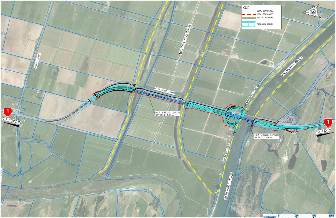
The existing Whirokino Trestle and Manawatu Bridge on SH1 between Foxton and Levin
requires replacement. The specimen design proposes an alignment which is adjacent and
parallel to the existing alignmen
t. Figure 1 shows the existing and proposed replacement
alignments and surrounding environment.
Throughout this report references to locations have been provided based on the SH1
southbound running distance from Culvert 9651 (at approximately Reference Station 954, Route
Position 11.0), as per the drawings. For Whirokino Road and Link Road the running distance is
Information
from the intersection with SH1, and for Matakarapa Road the running distance is from Link
Road.
Official
the
under
Released
Figure 1: Project Elements and Road Layout (Drawing 5002)
The project includes:
• 615 m Whirokino Trestle bridge.
GHD | Report for New Zealand Transport Agency - Whirokino Trestle and Manawatu River Bridge Specimen Design
Road Safety Audit, 51/34032/00 | 5
• 190 m Manawatu River Bridge.
• Embankment between the two bridges over farmland with a stock underpass.
• A new road (Link Road) from the northbound side of SH1, opposite Whirokino Road, in
a crescent shape joining onto Whirokino Road via an underpass of SH1. Matakarapa
Road connects to Link Road at a T junction approximately half way along with priority
given to Link Road.
• Realignment of Whirokino and Matakarapa Road with new intersection connections.
• A rest area and wetland at the southern side of the Manawatu River Bridge.
1982
• Shortening of a southbound passing lane.
• Improved facilities for cyclists using the existing cycle path adjacent to the Whirokino
Trestle.
Act
The specimen design resembles Option 2 from the preliminary design, with some alterations.
Information
Official
the
under
Released
6 |
GHD | Report for New Zealand Transport Agency - Whirokino Trestle and Manawatu River Bridge Specimen Design Road
Safety Audit, 51/34032/00
2.
Safety Audit Findings
2.1
Typical Section Issues
2.1.1
Solid White Centreline Marking
SIGNIFICANT
Frequency Rating
COMMON
Severity Rating
LIKELY
Outside of the project area, solid/continuous white centrelines and lane lines are typically used
where overtaking is not permitted, but has a lesser perception than no passing lines by the 1982
public at large. Examples of solid white lines not permitting overtaking are; approaching
intersections, level crossing, pedestrian crossings, raised islands, or flush medians. Using solid
white centrelines within the project will confuse users regarding if overtaking is, or is not
Act
permitted.
Recommendation
Alter wide centreline marking to either dashed white if overtaking is permitted or solid yellow if
overtaking is not permitted. Alternatively, a median treatment such as a wire-rope barrier or
flexible posts could be provided if overtaking is not permitted.
Designer Response
The NZTA Draft Wide Centreline Traffic Note allows for continuous or
Information
dashed wide centreline markings. We chose continuous markings for
maximum effectiveness as a head on crash countermeasure.
NZTA Draft ONRC cross section guidelines specify median barriers or
wide centreline for moderate volume National Strategic Highways and 3
or 4 lanes. In this case we have 2 lanes because of the high cost of
bridging. Official
Presumably the ONRC guidelines envisage a median barrier when
there is overtaking opportunity provided (3 or 4 lanes) and a wide
the
centreline when there are 2 lanes, so that overtaking can occur during
periods when traffic volumes are low. However this does not comply
with the safe system approach.
Our recommendation is to adopt a median barrier to provide a new
section of highway where head on crashes cannot occur.
under A median barrier would also address issue 2.2.1 below. Accordingly, a
wire rope median barrier would be our recommended centreline
treatment. Otherwise, we have no issues with providing a dashed wide
centreline instead of continuous wide centreline to address this audit
concern.
Safety Engineer
High Speed Passing - If vehicles overtaking one and other at high
speed are not vital to the function of this bridge, it may be best to
Released
prevent it through the design by including the median wire rope. The
location of the nearest passing opportunities to the bridge should be
part of this deliberation. The road will however have a clear view along
its length so high speed passing is not necessarily dangerous
(compared with a section with poor visibility).
Low Speed Passing - Low speed agricultural vehicles (tractors), may
GHD | Report for New Zealand Transport Agency - Whirokino Trestle and Manawatu River Bridge Specimen Design
Road Safety Audit, 51/34032/00 | 7
frequent this road and this is quite a long length to follow there is
insufficient room to pass. Encroachment onto a wide centreline is an
option for the following drivers, and still may be possible if there is a
median barrier system at a low speed.
In my opinion, if we believe that high speed head on crashes will be a
problem long term, I would rather see a wire rope barrier installed as
part of the design rather than taking a “wait and see” approach. If a
median barrier cannot be used as the passing opportunity is needed
(either high or low speed) then we stick with the typical wide centreline
design using the standard configuration for consistency (dashed lines
1982
or solid/dashed yellow).
There are two other considerations for the use of a median barrier. The
first is that a barrier will restrict the sight lines at some of the side
Act
accesses and there may be a condition on the consent around this.
Second there are maintenance issues around traffic control if a barrier
is installed.
Client Decision
The NZTA is currently investigating the installation of a central median
WRB.
Action Taken
Awaiting NZTA decision on whether to incorporate the wire rope
median barrier.
Information
2.1.2
Shoulder Width Consistency
MODERATE
Frequency Rating
INFREQUENT
Severity Rating
VERY LIKELY
Official
Shoulder widths between the bridge sections (1.5 m) and embankment sections (2.0 m) are
inconsistent. Variable widths will introduce a suddenly narrowing pinch point pushing vulnerable
users towards traffic. This variation in shoulder width was identified in the preliminary design
the
safety audit as issue 2.2.4 with a minor consequence. The detailed design shoulder widths
appear to have been reduced from the preliminary design Option 2.
Recommendation
Narrow the width of the marked shoulders at decision points (south of Culvert 9651 and south of
under
Link Road). Or; standardise the shoulder widths to provide a more consistent cross-section.
Designer Response
A path for vulnerable users is provided, except for on the Manawatu
River bridge. The other mitigating factor is that a wide centreline
provides additional road space for vehicles to shy away from cyclists.
Widening the bridge shoulders is desirable but unaffordable. There are
numerous safety benefits from having wide shoulders off the bridges so
Released
narrowing these shoulders to match the bridge width is not
recommended.
Safety Engineer
The approaches are straight and sight lines appear to be good, so a
cyclist or other vehicle on the verge is observable well in advance of the
narrowing. A more gradual transition could be part of the design.
8 |
GHD | Report for New Zealand Transport Agency - Whirokino Trestle and Manawatu River Bridge Specimen Design Road
Safety Audit, 51/34032/00
link to page 11 link to page 11 link to page 11
Client Decision
Agree with Safety Engineer’s response. Maintain variable shoulder
width (as described by the Designer) subject to suitable transitions
between variations in width.
Action Taken
The current Principal Supplied Design incorporates the Client
Decision, with a transition in width over the length of the
concrete barrier to W-Beam terminal transition. No further
action is required.
1982
2.1.3
Edge Marker Post Location
MINOR
Frequency Rating
INFREQUENT
Severity Rating
UNLIKELY
Act
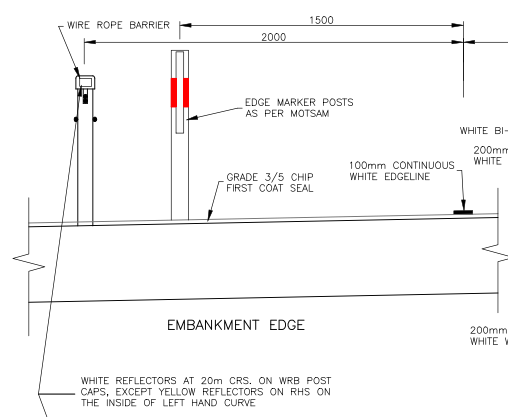
Edge marker posts have been included on the embankment sections of the new alignment
located 1.5 m from the edgeline, and 0.5 m from the wire-rope edge barriers as shown i
n Figure
2 below; it should be noted that
Figure 2 does not include planned edgeline ATP marking. Edge
marker posts at this location are a hazard/obstruction to road users on the shoulder such as
confident cyclists and hinder and increase required maintenance activities.
Information
Official
the
under
Figure 2: Embankment Shoulder Delineation Treatments
Recommendation
Released
Include edge marker posts as an attachment on the outside of the wire-rope barriers.
Designer Response
We agree with the audit recommendations because otherwise the edge
marker posts at 1.5m offset negate some of the benefits of providing a
GHD | Report for New Zealand Transport Agency - Whirokino Trestle and Manawatu River Bridge Specimen Design
Road Safety Audit, 51/34032/00 | 9
2.0m wide shoulder.
Safety Engineer
Support the auditors’ and designers’, recommendation.
Client Decision
Agree with the Safety Engineer’s response.
Action Taken
The current Principal Supplied Design incorporates the Client
Decision to move the EMP’s behind the barrier. No further
action is required.
1982
2.1.4
Audio Tactile Profiled Markings on Bridges
MINOR
Act
Frequency Rating
INFREQUENT
Severity Rating
UNLIKELY
The bridge and embankment sections of the realignment have different surfacing types. The
bridge sections (stone mastic asphalt – SMA) appears to be a single application, embankment
sections have two coat chip specified which are typically installed approximately 12 months
apart. Both the embankment and bridge will eventually have ATP marking, however there is no
economic reason to delay ATP marking on the bridge sections.
Recommendation
Install ATP on bridge sections after surfacing.
Information
Designer Response
While we agree with the audit concern, the cross section and road
marking dimensions are unique to this project and it may be preferable
to delay application of long life markings until satisfactory operation is
confirmed.
Official
Safety Engineer
I understand the designer’s reluctance to install the long life markings
with elements of the layout being untested. I recommend that there is a
the
short timeframe for a post construction review of the edge lines and
once completed, install the ATP markings as soon as possible.
Client Decision
Agree with the Safety Engineer’s response.
Action Taken
An instruction will be issued to apply the ATP markings on the
under bridges a short time after initial marking, rather than in sync
with the markings on the chipseal as stated in PR A9.2.4.
2.1.5
Bridge Delineation
COMMENT
Frequency of delineators on the bridge sections have not been indicated on drawing 5361.
These should be consistent with wire-rope barrier delineators on embankment sections.
Released
10 |
GHD | Report for New Zealand Transport Agency - Whirokino Trestle and Manawatu River Bridge Specimen Design Road
Safety Audit, 51/34032/00
2.1.6
Local Road Shoulder/Berm Layers
COMMENT
Drawing 5222 shows typical sections for the local roads (Whirokino Road, Matakarapa Road,
and Link Road). The pavement layer and Topsoil & Grass Berm are shown to overlap. A thick
layer of topsoil overlapping the pavement layer increases maintenance costs.
1982
Act
Information
Official
the
under
Released
GHD | Report for New Zealand Transport Agency - Whirokino Trestle and Manawatu River Bridge Specimen Design
Road Safety Audit, 51/34032/00 | 11
2.2
Specific Location Issues on SH1
2.2.1
Right Turns at Intersections
SERIOUS
Frequency Rating
FREQUENT
Severity Rating
LIKELY
Whirokino Road and Link Road are proposed to operate as left-in left-out connections to SH1.
No Right Turn signs (RG-7) are used to discourage right turn movements. These measures are
not effective as a deterrent for determined right turn movements made for convenience.
Recommendation
1982
Consider a physical restraint in the median area to prevent right turn movements such as
flexible posts or a wire-rope barrier.
Act
Consider an expressway style schematic advanced directional sign, similar to AD-4 or AD-5,
(which might be out of context for the rural road environment).
Designer Response
In this case, right turn movements are able to be made as left turn
movements, via the underpass. The key will be to get people to use
the underpass, rather than risk turning right. We think the guide signs
at the Matakarapa and Whirokino Road intersections with Link Road
will provide sufficient information for drivers to use the intersections
correctly if they choose to do so. However, in practice, people may turn
Information
right when traffic conditions are light, but would use the grade
separation when traffic is heavy.
Safe hit posts could be installed in the wide centreline if right turns
prove to be a problem however no overtaking lines would then need to
be marked for a considerable distance in either direction to prevent
overtaking vehicles from running into them.
Official
A median barrier continuous throughout the length of the project would
provide the ultimate solution to this safety issue.
the
Safety Engineer
As the right turns are not necessary due to the underpass configuration,
there is no problem using a median barrier to preclude right turn
movements.
If the median barrier is not part of the final design, the use of signage to
under direct the traffic is OK; they will only cross right if the traffic is light and
the sight lines will be adequate for the right turn if they opt for this.
Client Decision
The NZTA is currently investigating the installation of a central median
WRB.
Action Taken
Awaiting NZTA decision on whether to incorporate the wire rope
median barrier.
Released
2.2.2
Farm Access at 2400 m
SERIOUS
Frequency Rating
COMMON
Severity Rating
VERY LIKELY
12 |
GHD | Report for New Zealand Transport Agency - Whirokino Trestle and Manawatu River Bridge Specimen Design Road
Safety Audit, 51/34032/00
Access to the farm (1187 SH1, Levin) will be provided from the northbound side of SH1 at
2400 m. This location is at the beginning of the southbound passing lane. The access will be
constructed according to a modified diagram D, and will not have right turn provision.
Diagram D in the Planning Policy Manual has at least 6 m of carriageway space from the
centreline for 90 m either side of the access (excluding the nearside departure), this is not
achieved at this location with the wire-rope barrier located 5.5 m from the centreline on the
northbound side at 2400 m and 2450 m in drawings 5260 and 5261.
This access is located in a high speed environment between a long straight with a wide road
and a 110 km/h design speed curve with passing lane.
1982
The location of this access will cause confusion as vehicles indicating to turn right into the
access could be mistaken for indicating that they are going to overtake, resulting in rear-end
impacts. While rear-end crashes typically have lower occurrence of death or serious injury
Act
outcomes, at this location the right turning vehicle would most likely be pushed into the
northbound lane and increase the likelihood of the crash becoming a head-on impact.
Recommendation
Consider how this access could interact with neighbouring access at 2275 m on the southbound
side of the road as a system and prevent right turn movements with a median treatment (see
recommendation 2.1.1 and 2.1.2).
Designer Response
While the layout is not ideal, the existing road layout has the entrance
Information
within the actual passing lane which arguably is less safe than what is
proposed.
On the southbound side the edge barrier is offset 3.0m. This could be
widened to say 3.5m over a distance of 90m either side of the entrance,
giving additional space for through vehicles to manoeuvre around a
Official
vehicle turning right.
On the northbound side the barrier offset could similarly be increased to
3.5m over a distance of 90m either side of the entrance.
the
The wide centreline or median barrier could be extended further south
across the entrance. This has not been investigated in detail. There
could be design issues and safety issues associated with tapering back
to a standard centreline within the passing lane and within a curve.
under In terms of interaction with the entrance at 2275m there are no direct
turning conflicts however ideally these entrances would be spaced
further apart to prevent any interaction between decelerating and
accelerating vehicles and through traffic.
A median barrier to prevent right turns at these access ways would
require a safe turn around facility to be provided. To the north the new
Whirokino/Matakarapa Road intersection would provide a suitable
turning facility. Currently there is no equivalent safe turn around facility
Released
to the south.
Safety Engineer
Ultimately, the design is an improvement over the existing situation.
The increase in offset described by the designer is an option that
should be considered at this stage.
GHD | Report for New Zealand Transport Agency - Whirokino Trestle and Manawatu River Bridge Specimen Design
Road Safety Audit, 51/34032/00 | 13
Client Decision
Agree with the Safety Engineer’s response.
Action Taken
The current Principal Supplied Design incorporates the Client
Decision, including the increased offset. No further action is
required.
2.2.3
Rest Area and Wetland Access at 2275 m
SIGNIFICANT
1982
Frequency Rating
COMMON
Severity Rating
LIKELY
Access to the rest area and wetland will be provided from the southbound side of SH1 at
2275 m. This location is where the wide centreline is tapering back to a normal centreline. The
Act
access will need to be constructed according to diagram D, and will not have right turn
provision.
Diagram D is not achieved at this location with the wire-rope barrier located 5.5 m from the
centreline on the northbound side from 2350 m to 2200 m in drawings 5259 and 5260.
This access is located in a high speed environment between a long straight with a wide road
and a 110 km/h design speed curve with passing lane.
Recommendation
Information
Consider the provision of a right turn bay. Or, how this access could interact with neighbouring
access at 2400 m on the northbound side as a system and prevent right turn movements.
Designer Response
Irrespective of the above issues being addressed, a reduction in
movements by moving the rest area to an alternative site within the Link
Official
Road loop could be considered.
A median barrier would introduce the need for a safe turn around to the
south and potentially issues with providing a safe transition back to the
the
standard centreline (refer above).
To provide road space for through vehicles to manoeuvre around
slowed or stopped vehicles turning into and out of the entrance, barrier
offsets could be increased over a distance of 90m either side of the
entrance.
under
Safety Engineer
Consider moving the site as discussed by the designer as avoidance is
better than any likely mitigation.
Increase the offsets as described if this is unable to be undertaken.
Client Decision
Agree with the Safety Engineer’s response. Also, the NZTA is currently
investigating the installation of a central median WRB.
Released
Action Taken
The current Principal Supplied Design incorporates the Client
Decision, including the increased offset. No further action is
required.
14 |
GHD | Report for New Zealand Transport Agency - Whirokino Trestle and Manawatu River Bridge Specimen Design Road
Safety Audit, 51/34032/00
2.2.4
Cyclist Permanent Warning Signs
MODERATE
Frequency Rating
INFREQUENT
Severity Rating
LIKELY
Permanent warning signs have not been provided on the approaches at the locations where
cyclists re-join SH1 from the shared path. Cyclists re-join SH1 at 120 m for northbound, and
1700 m southbound.
Recommendation
Provide PW-35 signs 160 m prior to cyclists re-joining SH1 as per MOTSAM.
1982
Designer Response
Agree with safety audit recommendations.
Act
Safety Engineer
Agree with the auditors and designers’ recommendations.
Client Decision
Agree with the Safety Engineer’s response.
Action Taken
The current Principal Supplied Design incorporates the Client
Decision to add PW-35 signs. No further action is required.
2.2.5
Warning and Directional Sign Frequency
MINOR
Information
Frequency Rating
INFREQUENT
Severity Rating
UNLIKELY
There is a high frequency of road signs in both directions between the Whirokino Road and Link
Road intersection and the southbound passing lane. Closely spaced signs can obscure or
detract from other signs.
Official
The following sign sequences are closely spaced:
Northbound; RG-7 (1750 m), Cycle path closure sign, Link Road Motorist Service &
Street Name signs (1710 m)
the
Southbound; Motorist Service sign (1840 m) and IG-14 (1845 m)
Northbound; PW-48 (1880 m) and PW-9 (1845 m)
Southbound; PW-48 (2005 m) and IG-6 (2045 m)
under
Recommendation
Consider sign configuration along SH1 with regards to longitudinal, vertical, and horizontal
placement along the roadside in accordance with MOTSAM. Particular concern should be used
with permanent warning signs and directional information signs.
Designer Response
We agree that sign locations could be improved and will update the
sign drawings to address these issues as far as practicable.
Released
Safety Engineer
Support the designers reviewing of sign placement.
Client Decision
Agree with the Safety Engineer’s response.
Action Taken
The current Principal Supplied Design incorporates the Client
Decision, including revised sign locations. No further action is
GHD | Report for New Zealand Transport Agency - Whirokino Trestle and Manawatu River Bridge Specimen Design
Road Safety Audit, 51/34032/00 | 15
required.
2.2.1
Northern Curve Super-elevation
COMMENT
The northern curve (from 85 – 580 m) has a super-elevation of 7%. The Whirokino Trestle
bridge starts at 575 m. The curve super-elevation returning to typical elevation occurs on the
Whirokino Trestle. While this is not a safety issue it does add construction difficulties.
1982
2.2.2
Passing Lane Length
COMMENT
The existing passing lane from 2400 m onwards currently has a length of 750 m (excluding
Act
tapers). This project will reduce the passing lane length to 650 m (excluding tapers). While this
is above absolute minimum standards, its effectiveness will be reduced and impact SH1 safety
downstream (outside of the project extent).
Information
Official
the
under
Released
16 |
GHD | Report for New Zealand Transport Agency - Whirokino Trestle and Manawatu River Bridge Specimen Design Road
Safety Audit, 51/34032/00
2.3
Local Road Issues
2.3.1
Whirokino Road Curve at 200 m
MODERATE
Frequency Rating
OCCASIONAL
Severity Rating
LIKELY
This curve, which will retain the current alignment and form, is short and has low radius
(approximately 50 m) and is located at the end of a straight. Link Road is proposed to joining the
apex of this curve. Approach speed to this curve was identified in the preliminary design safety
audit as issue 2.3.7 with a moderate consequence, with advisory speed signs as the
recommendation.
1982
Recommendation
Provide curve advisory speed sign and chevron curve indicators. And/or; realign the existing
Act
curve and extend the Link Road connection.
Designer Response
Curve realignment would require an alteration to designation. A curve
advisory speed sign and chevron curve indicators are therefore
recommended to address this risk.
Safety Engineer
Install curve-warning signs as recommended by designer.
Client Decision
Agree with the Safety Engineer’s response.
Information
Action Taken
The current Principal Supplied Design incorporates the PW-17 /
PW-25 sign combination but not the chevron Board. An
instruction will be issued to add a PW-66 chevron board.
Official
2.3.2
Local Road Embankment Hazard Protection MODERATE
the
Frequency Rating
OCCASIONAL
Severity Rating
LIKELY
Whirokino Road and Link Road approaches to SH1 are on embankments. The W-section barrier
on SH1 extends around the intersection curve for the first 20 m of these two roads. This leaves
the remainder of the approach embankments with unprotected slopes. Unprotected slopes on
the approach roads were identified in the preliminary design safety audit as issue 2.3.2 with a
under
significant consequence, with barrier protection or reduced embankment slope as the
recommendation.
Recommendation
Extend w-section barrier around the outside of the approach curves on Whirokino Road and
Link Road.
Released
Designer Response
Ideally barrier would be provided however batter slopes are traversable
for light vehicles (4:1) and speeds are low.
Safety Engineer
The 4:1 batter slope is the maximum gradient and 6:1 is recommended
in the SH design manual (part 6). In this case, 4:1 is adequate as the
actual speeds on these road will be quite low and crashes will be
GHD | Report for New Zealand Transport Agency - Whirokino Trestle and Manawatu River Bridge Specimen Design
Road Safety Audit, 51/34032/00 | 17
unlikely, though care will need to be taken to consider if this slope is a
risk to errant vehicles on the main road.
Client Decision
Agree with the Safety Engineer’s response.
Action Taken
No action required. The slopes are shielded from main road traffic by
continuous side barriers.
2.3.3
Cyclist Warning Signs
MODERATE
1982
Frequency Rating
OCCASIONAL
Severity Rating
LIKELY
The northbound and southbound cycle routes traverse Whirokino Road and Link Road between
Act
SH1 and the shared path. Link Road is only 6 m wide at the underpass which is very narrow to
accommodate north bound cyclists as well as vehicle traffic in both directions.
Cyclist numbers on these roads near SH1 will be out of context with the surrounding rural road
network in Horowhenua and cyclist presence maybe unexpected for vehicle drivers.
Recommendation
Provide warning to vehicle operators of the presence of cyclists at the narrowing of Link Road.
Provide PW-35 signs on Whirokino Road and Matakarapa Road prior to the Link Road
Information
intersection.
Designer Response
Agree with audit recommendations.
Safety Engineer
Agree with the auditors and designers’ recommendations.
Official
Client Decision
Agree with the Safety Engineer’s response.
Action Taken
An instruction will be issued to add the PW-35 signs.
the
2.3.4
Whirokino Road and Link Road Intersection MINOR
under
Frequency Rating
INFREQUENT
Severity Rating
UNLIKELY
The Link Road approach to Whirokino Road has a downward gradient of 7.3% for the final 17 m
i.e. the super-elevation of the Whirokino Road curve. This downward slope and the transition
onto Whirokino Road may create a tipping risk for high-sided vehicles turning right from Link
Road onto Whirokino Road.
Recommendation
Consider realigning the existing curve on Whirokino Road and extend the Link Road connection
Released
to achieve a shallower approach slope.
Designer Response
Curve realignment would require an alteration to designation.
18 |
GHD | Report for New Zealand Transport Agency - Whirokino Trestle and Manawatu River Bridge Specimen Design Road
Safety Audit, 51/34032/00
Safety Engineer
Contemplate the likelihood of high-sided vehicles using this link road
and if it is frequent, consider making the required adjustments to the
designation.
Client Decision
Agree with the Safety Engineer’s response.
Action Taken
Very few high sided vehicles will use the intersection, so no action
taken.
1982
2.3.5
Link Road SH1 Bridge Underpass Drainage
COMMENT
The planned Link Road passes underneath the SH1 Manawatu River Bridge. At this location the
Act
Link Road is at a low point, and consequently prone to flooding. A culvert drain has is indicated
on Drawing 5222 but it is unknown if this is sufficient to clear surface water at this location
2.3.6
Local Road Directional/Guide Signage
COMMENT
On the local roads, directional and guide signage provides guidance for northbound and
southbound cyclists and vehicles using “Foxton” and “Levin”. Using town names will assist local
users who are familiar with the area, however could provide confusion for users unfamiliar with
the area such as cycle tourists.
Information
Official
the
under
Released
GHD | Report for New Zealand Transport Agency - Whirokino Trestle and Manawatu River Bridge Specimen Design
Road Safety Audit, 51/34032/00 | 19
2.4
Cyclist and Shared Path Issues
2.4.1
Directional Guidance for Northbound Cyclists onto the Shared Path
SIGNIFICANT
Frequency Rating
OCCASIONAL
Severity Rating
VERY LIKELY
Northbound cyclists crossing the Manawatu River Bridge lack clear directional signs indicating
the safe routes for them to access the shared path. This could result in northbound cyclists
accessing the shared path by turning right at the SH1 Whirokino Road intersection.
1982
Recommendation
Provide clearer signage for northbound cyclists to the presence and access method for the
shared path. This could be a schematic sign in combination with vehicle users.
Act
Designer Response
Cycle guide signs wil be reviewed. “Cycle Route North” could be used
in lieu of the “Cycle Path Open” sign. Various map signs have been
considered for motorists and cyclists and our conclusion has been that
these are too complex to be read by motorists.
Safety Engineer
Clear signage is being planned. Post construction, monitor the cyclists
feedback and make the necessary alterations if needed.
Information
Client Decision
Agree with the Safety Engineer’s response.
Action Taken
The current Principal Supplied Design includes the guide sign
“Cycle Path North” at the point where northbound cyclists will
need to turn left into Link Road to access the cycleway. This may
or may not be sufficient to address the issue. No further action
Official
is proposed until post construction feedback from users is
available.
the
2.4.2
Northbound Shared Path Bridge Clearance
MODERATE
Frequency Rating
INFREQUENT
Severity Rating
LIKELY
under
The northbound connection of the shared path to SH1 (at 600 m to 120 m) passes under the
Whirokino Trestle bridge while climbing the Moutoa Floodway stopbank. The height between the
shared path and bottom of the bridge deck has not been provided. Cyclists require adequate
space
Recommendation
Consider the clearance height for shared path users on the northbound shared path.
Released
Designer Response
The vertical alignment design of the path was not complete at time of
the audit. We are confident that clearance of at least 2.2m can be
provided which meets AUSTROADS cycle envelope requirements. The
horizontal alignment of the path can be adjusted if necessary to achieve
20 |
GHD | Report for New Zealand Transport Agency - Whirokino Trestle and Manawatu River Bridge Specimen Design Road
Safety Audit, 51/34032/00
this.
Safety Engineer
Adjust horizontal alignment if required during design. 2.2m minimum is
recommended.
Client Decision
Agree with the Safety Engineer’s response.
Action Taken
The current Principal Supplied Design has the required clearance.
No further action is required.
1982
Act
2.4.3
Shared Path Northern Directional Guidance
MODERATE
Frequency Rating
OCCASIONAL
Severity Rating
LIKELY
There has been no provision of directional guidance at the northern end of the shared path
where the northbound and southbound path splits. This could lead northbound path users to
take the southbound path and emerge on the incorrect side of SH1.
Recommendation
Provide directional guide signs on shared path.
Information
Designer Response
An appropriate sign can be added.
Safety Engineer
Recommend sign is added.
Official
Client Decision
Agree with the Safety Engineer’s response.
Action Taken
The current Principal Supplied Design has a sign at the fork
directing cyclists onto the correct branch of the path to Foxton.
the
No further action is required.
2.4.4
Shared Path Central Stopbank Crossing
MODERATE
under
Frequency Rating
INFREQUENT
Severity Rating
LIKELY
The shared path appears to retain the existing alignment when crossing the Moutoa Floodway
southern stopbank. At this location there is low forward sight distance due to the vertical and
horizontal alignment. Southbound and northbound users travelling at speed may not have time
to see and react to users travelling in the same or opposite direction.
Recommendation
Released
Consider the alignment, approach slope, width, and centreline delineation of the shared path to
achieve separation of users at this location.
Designer Response
Conflict with opposing direction users could be avoided by applying a
GHD | Report for New Zealand Transport Agency - Whirokino Trestle and Manawatu River Bridge Specimen Design
Road Safety Audit, 51/34032/00 | 21
centreline (locally, over the stop bank only) and keep left signs.
Conflicts in the same direction are less likely and we think have a low
risk of occurrence and injury.
Safety Engineer
Support the use of signage in this case advising keep left. Arrows on
the surface of the shared path could also be considered.
Client Decision
Agree with the Safety Engineer’s response.
Action Taken
The current Principal Supplied Design includes centreline
marking over the stopbank. An instruction will be issued to add
1982
cyclist keep left signs.
Act
2.4.5
Shared Path Farm Gate
MODERATE
Frequency Rating
OCCASIONAL
Severity Rating
LIKELY
At 1500m two gates cross the shared path. These gates appear to connect farmland with the
agricultural underpass. These gates have permanent warning (PW-37) signs in advance as well
as “Please Close Gate” signs at the gate. Stopping and dismounting a bike to open and close
two gates is a significant hindrance to travel time and will detract cyclists from using the shared
path, and instead continue along SH1 across the Whirokino Trestle bridge and embankment. It
Information
must be remembered that a shared path is effectively a legal road and the users have the legal
right of way.
Recommendation
Provide gates for the farmer to operate rather than putting the onus on shared path users and/or
provide cyclist safe cattle stops on the shared path approaches.
Official
Designer Response
Land owner agreements do not allow the priority to be changed.
the
Safety Engineer
Consider the cycle safe cattle stops.
Client Decision
Agree with Designer’s comments.
Action Taken
The Principal Supplied Design includes the gates, in keeping with
under the property agreement. Cattle stops would potentially allow
cyclists to conflict with stock. No action taken.
2.4.6
Shared Path Curves
MINOR
Frequency Rating
OCCASIONAL
Severity Rating
UNLIKELY
Released
Two sharp curves on the shared path at 600 m and 1675 m. These two curves do not appear to
have considered radius or superelevation to meet cyclists’ speeds. Cyclists consequently have
the risk of crashing on these curves.
The curve at 600 m which is for southbound users appears to use the existing northbound
shared path connection to SH1.
22 |
GHD | Report for New Zealand Transport Agency - Whirokino Trestle and Manawatu River Bridge Specimen Design Road
Safety Audit, 51/34032/00
link to page 25
 Recommendation
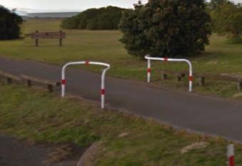
Consider cyclists speeds when providing low radius curves on the shared path. If the intention
of these low radius curves is to prevent motorised vehicles from using the path then consider
using barriers with a narrow opening rather than low radius curves. See
Figure 3 below.
1982
Act
Figure 3: Example Vehicle Exclusion Barriers
Designer Response
Agree with audit concerns. The curves will be eased.
Safety Engineer
Support easing of the curves.
Client Decision
Agree with the Safety Engineer’s response.
Information
Action Taken
An instruction will be issued to amend the Principal Supplied Design
to increase the curve radii at these locations.
2.4.7
Shared Path Vehicle Exclusion
MINOR
Official
Frequency Rating
INFREQUENT
Severity Rating
UNLIKELY
the
No provision for the exclusion of vehicles from the shared path has been provided in drawings.
Recommendation
Provide mechanisms which do not hinder cyclists, to exclude non-maintenance vehicles from
the shared path at the southern end and on the northbound and southbound connections to
under
SH1 at the northern end (see example in recommendation 2.4.6 above.
Designer Response
Agree with audit recommendations.
Safety Engineer
Agree with audit recommendations.
Client Decision
Agree with the Safety Engineer’s response.
Released
Action Taken
The Principal Supplied Design includes barriers/bollards at the start of
the path on each side at the northern end, and at the southern end. No
further action required, other than to specify the type of barrier/bollard.
An instruction will be issued to clarify, based on the exclusion barriers
illustrated in Figure 3.
GHD | Report for New Zealand Transport Agency - Whirokino Trestle and Manawatu River Bridge Specimen Design
Road Safety Audit, 51/34032/00 | 23
2.4.8
Shared Path Southern Terminus
MINOR
Frequency Rating
INFREQUENT
Severity Rating
UNLIKELY
The southern terminus of the shared path joins Whirokino Road between SH1 and the Link
Road. This requires cyclists to turn right across Whirokino Road at a mid-block. Vehicle drivers
would have increased awareness of cyclists turning at intersections.
Recommendation
1982
Consider relocating the shared path terminus on Whirokino Road to opposite Link Road.
Act
Designer Response
The intention is to minimise the length of the route from path to road
shoulder for southbound cyclists, which will encourage more use of the
path. Moving the path junction to the intersection adds 100m and is not
recommended given that traffic volumes and speeds on Whirokino
Road are low and good sight distance is provided.
Safety Engineer
An extensions to a route which requires human powered is not
recommended if you want cyclists to prefer it to the bridge.
If the sight lines are adequate and the speed is low, this should not be a
problem.
Information
Client Decision
Agree with the Safety Engineer’s response.
Action Taken
Sight lines are adequate and speeds are low. Accordingly, no action is
required.
Official
2.4.9
Shared Path Maintenance
COMMENT
the
The existing shared path has a low level of maintenance which makes the pathway unattractive.
Grass is growing in cracks throughout the path, at the farm stock crossing, a considerable layer
of mud and excrement appears to have built up. Cyclists need facilities which are safe,
convenient, and attractive to utilise.
under
Released
24 |
GHD | Report for New Zealand Transport Agency - Whirokino Trestle and Manawatu River Bridge Specimen Design Road
Safety Audit, 51/34032/00
2.5
Other Comments
2.5.1
Drawing Labels
COMMENT
Drawing 5206: Longsection of MC10 labelled Whirokino Road instead of Link Road.
Drawing 5207: Longsection of MC20 labelled Link Road instead of Whirokino Road.
2.5.2
Drawing Ambiguities
COMMENT
1982
Drawing 5201: Swale drawn on western side of embankment and at no other locations
throughout drawing set. This swale has not been included in the key.
Drawing 5204: Parallel blue lines on either side of SH1 near New Wetland Access label. It
Act
is unclear what these lines mean.
Drawing 5206: Link Road does not include w-section barriers included in drawing 5222.
Information
Official
the
under
Released
GHD | Report for New Zealand Transport Agency - Whirokino Trestle and Manawatu River Bridge Specimen Design
Road Safety Audit, 51/34032/00 | 25

 3.
Audit Statement
3.
Audit Statement
We certify that we have used the available plans, and have examined the specified roads and
their environment, to identify features of the project we have been asked to look at that could be
changed, removed or modified in order to improve safety. The problems identified have been
noted in this report.
1982
Signed:
Dated:
20 May 2016
s 9(2)(a)
, GHD Limited
Act
Signed:
Dated:
20 May 2016
Out of Scope New Zealand Transport Agency
Information
Designer: Name……………………………………………. Position………………………..
Signature……………………………………………….Date…………………………….
Official
Safety Engineer: Name………………………… Position…………….
the
Signature……………………………….. …………….Date…………………………….
Project Manager: Name………………………………… Position………………………..
under
Signature……………………………………………... Date…………………………….
Action Completed: Name…………………………………Position………………………..
Signature…………………………………………..….. Date…………………………….
Released
Project Manager to distribute audit report incorporating decision to designer, Safety
Audit Team Leader, Safety Engineer and project file. Date:……………………..
26 |
GHD | Report for New Zealand Transport Agency - Whirokino Trestle and Manawatu River Bridge Specimen Design Road
Safety Audit, 51/34032/00


1982
Act
Information
Official
GHD
Level 1, Grant Thornton House
the
215 Lambton Quay, Wellington 6011
T: 64 4 472 0799 F: 64 4 472 0833 E: [email address]
© GHD Limited 2016
under
This document is and shall remain the property of GHD. The document may only be used for the
purpose for which it was commissioned and in accordance with the Terms of Engagement for the
commission. Unauthorised use of this document in any form whatsoever is prohibited.
G:\51\34032\WP\Whirokino Trestle Manawatu Bridge Specimen Design Safety Audit.docx
Document Status
Rev Author
Reviewer
Approved for Issue
No.
Name
Signature
Name
Signature
Date
1
s 9(2)(a), Out of Scope
Out of Scope,
19/5/2016
s 9(2)(a)
Released
2

1982
Act
Information
www.ghd.com
Official
the
under
Released