 Treatment Options for Coastal Erosion at Plimmerton Fire Station
The dunes in front of the Plimmerton Fire Station have experienced ongoing erosion
over the past few years and the beach is now in a degraded state.
The sand dunes are relatively recent, having accreted largely since the fire station
was constructed in 1955, which has provided a wind barrier for sand to accumulate.
In order to construct the station, a small pocket beach and part of the rock shore
platform on the point between Plimmerton Beach and Karehana Bay was reclaimed.
There are historical accounts that sand was present along the shore. This is
supported by aerial photographs dating from 1942, but they do not indicate there was
a dune system (aside from a few low sand hummocks) at this site prior to
construction of the station (Figure 1).
In geomorphological terms therefore, the presence of the dunes can be partly
attributed to human activities, rather than pure natural processes. Nevertheless, they
form an aesthetic edge to what would otherwise be a concrete barrier.
Over time, the dunes and beach have formed around the edge of the station under
the action of wind and waves transporting sand along and up the shore. A series of
large storm tide events in the past 12-18 months have caused the beach to become
heavily eroded. Old shore protection works have been exposed at the front of the
station, testament to either previous responses to erosion or part of the original
reclamation.
Presently, old clay and gravel basecoarse from construction of the road berm and
building platform is present at the base of the dunes, interspersed with hardfill
(concrete blocks, rocks and bricks) and old shore protection structures (filled
concrete drums).
A vegetative cover of marram (Ammophila arenaria), South African ice plant
(Carpobrotus edulis) and taupata (Coprosma repens) covers the degraded dunes.
Also present is some spinifex (spinifex sericeus) planted at the southern edge of the
site. This vegetation is insufficient to provide much holding capacity for the sand and
the site will face ongoing erosion from high tides and storm events.
The most cost effective option will be to undertake a small beach renourishment and
dune restoration programme.
WGN_DOCS-#1015070-v1
1
A dune restoration needs as much room as possible to allow fluctuations in the
beach from erosion. Because the site is narrow and perched on a rock shore
platform, it doesn’t have a large volume of sand, thus it is vulnerable to erosion from
storm events. It also makes it harder for vegetation to recover from storm damage.
The site can be broken down into 4 areas on the basis of its exposure and
geomorphology; the southern edge; the western edge; the northwest corner and; the
northeast corner. Each of these areas will require a slightly different approach and
can be tackled one at a time to stage the project over a couple of seasons.
As a rule of thumb the minimum width need to maintain a dune is 10 m. The front
western edge of the site has approximately this width available. The old drums
should be removed and some sand renourishment undertaken to reshape the dune
to make up for the loss of volume. As discussed on site, it would be desirable to
remove part of the paved area in front of the firehouse to free up a bit more width and
increase the resilience the beach and dune, however, this isn’t essential. In doing
this, some of the vegetation will also be removed, which will require replanting. The
best choice will to plant with spinifex. Any remaining marram and ice plant should be
sprayed. The reason for this is that marram does not recover well from storm erosion
and exacerbates sand loss from the beach as it creates a vertical scarp that is easily
undermined by wave activity. This is what is partly contributing to erosion at the site.
Spinifex creates a more rounded dune form with creeping runners that grow over an
erosion scarp and are better able to recover the beach (figure 2).
The northern and southern sides are a lot more squeezed. In particular, the
northwest corner of the building has less than half the required distance for a dune
restoration. It may not be possible to establish a functional dune at this pinch point.
The best option is to renourish the backshore with sand to repair the blowout and
rebuild the beach, and allow dunes to establish in adjacent areas. Any fill in here,
such as the old clay basecoarse should be removed. Clay in particular is detrimental
to a beach because it filters into the pore spaces between the sand and reduces its
capacity to absorb wave runup. This in turn enhances scouring of the beach during
storm conditions. The backshore can then be planted to stabilize the sand and
provide some amenity plantings (Figure 3).
The northeastern corner is a natural point of sand accumulation as the reclamation
acts as a groyne to sand transported southward during north and northwest
conditions. There is enough width here to maintain the small beach and dune with
some native plantings.
The southern edge of the site has had some spinifex planting, but it too has become
degraded by storm wave activity. In general, the spinifex has performed well and is
currently holding a reasonable volume of material. The best option is to renourish the
toe with sand to give a foothold for the spinifex at the crest to grow into (Figure 4).
2
WGN_DOCS-#1015070-v1
In summary, it is recommended that the restoration is undertaken with the following
steps (a summary is provided in Figure 5):
1. Remove old fill (particularly old concrete blocks, rusting drums and clay
material) as this inhibits plant growth and provides scour points for wave
and current activity during storm events.
2. Replenish the beach and dunes with sand and reshape the eroded dune
scarps. (A good source for the renourishment would be sand dredged from
the marina).
3. Spray out the remaining invasive exotic plants, especially the marram and
ice plant that will outcompete native sand binders, but leave in place to
hold the sand until native plants become established.
4. Bulk plant with spinifex above MHWS at approx. 0.75 m spacings to get a
plant cover established. This is best achieved in April to May after the
March equinox winds and prior to winter rainfall.
5. Could also add in some pingao (Ficinia spiralis) (best in clustered groups)
and sand tussock (Poa billardierei was Austrofestuca littoralis) for a bit of
plant variety at the crest.
6. Replenish periodically with sand to top up the beach and provide material
for spinifex to help grow the dunes and provide a buffer to the station.
Such a project is not without risk. There is always the possibility that a storm event
causes damage to the restoration while it is becoming established. In addition, there
will be ongoing periods of erosion from time to time. In the long term, this will be
exacerbated by sea level rise. But these risks are outweighed by the benefits, which
is to restore a beach asset for the community whilst at the same time provide a soft
engineered shore protection solution for the fire station.
Dr Iain Dawe
Senior Policy Advisor (Hazards)
Greater Wellington
09/02/2012
WGN_DOCS-#1015070-v1
3
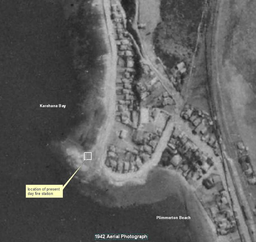 Figure 1:
 1942 Aerial photograph showing location of present day fire station which
was constructed on the beach and shore platform on the point between Plimmerton
Beach and Karehana Bay.
4
WGN_DOCS-#1015070-v1
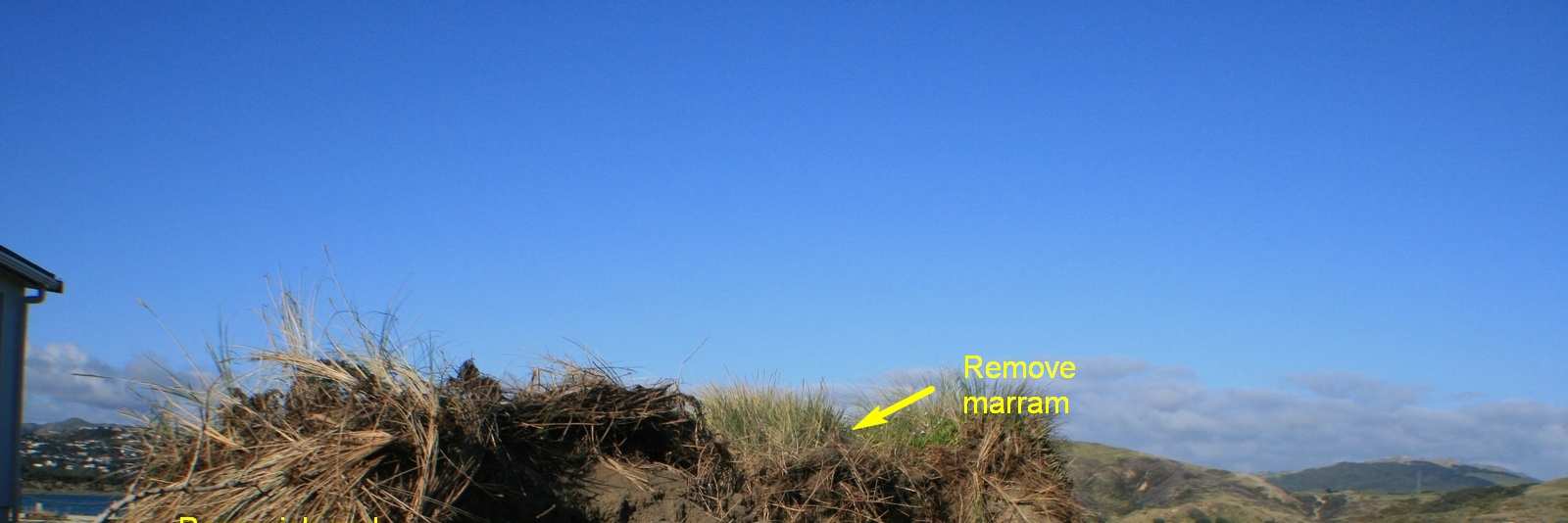
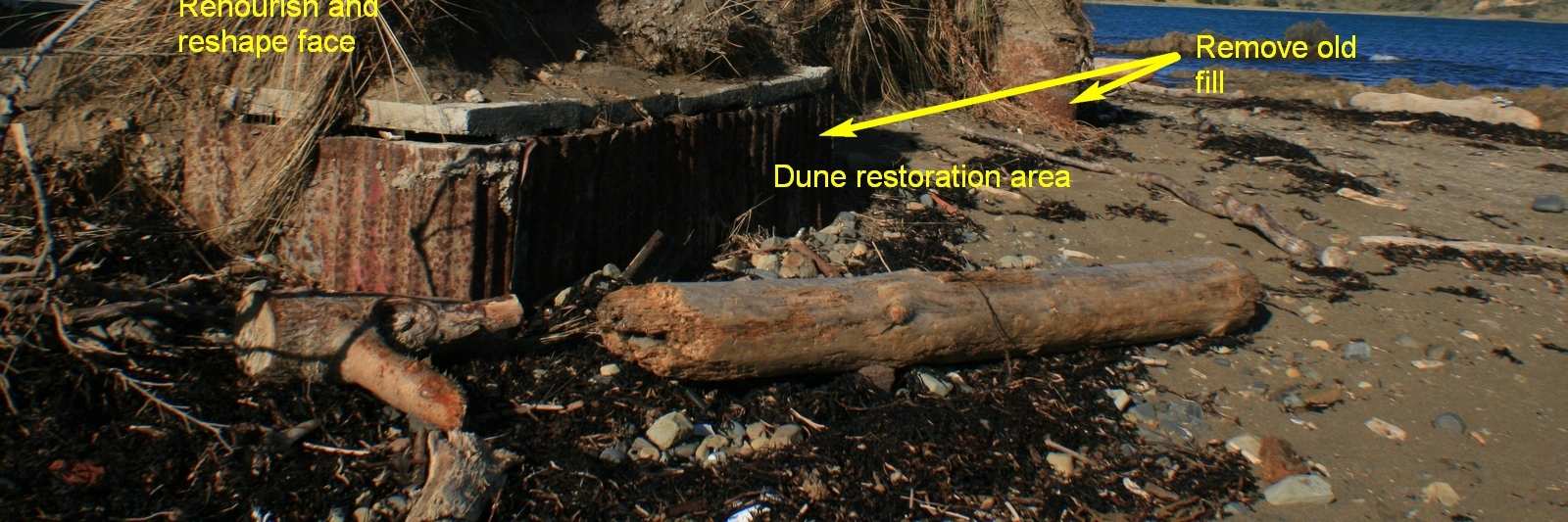
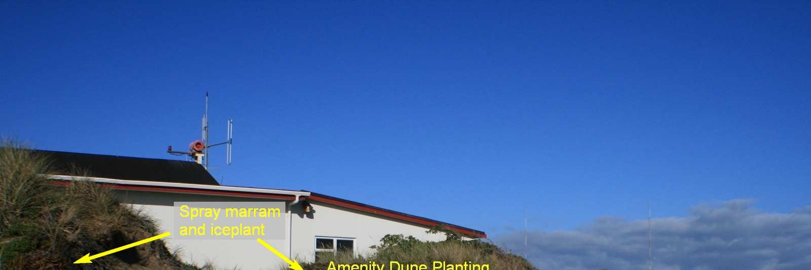
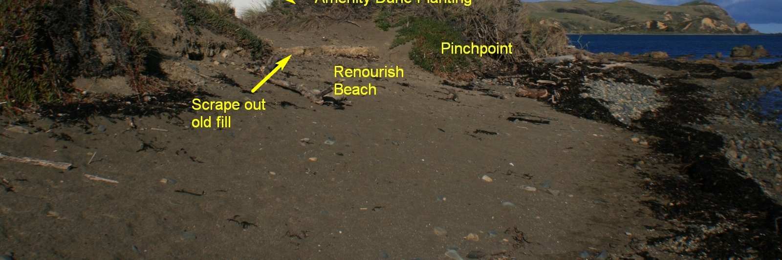 Figure 2:
 Western edge (front) of the site
Figure 3: Northwest corner of the site
WGN_DOCS-#1015070-v1
5
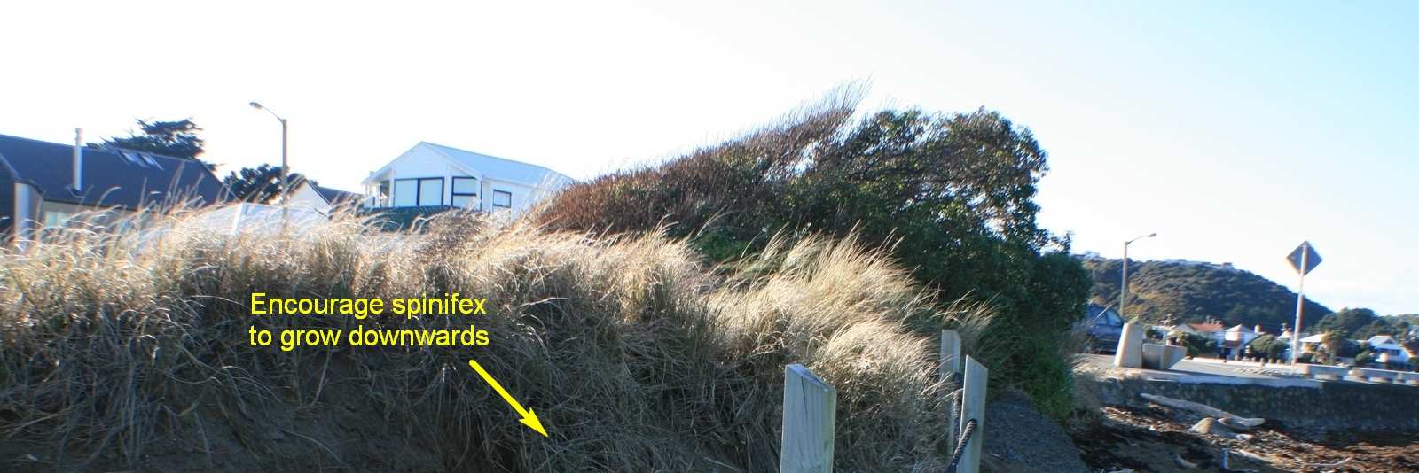
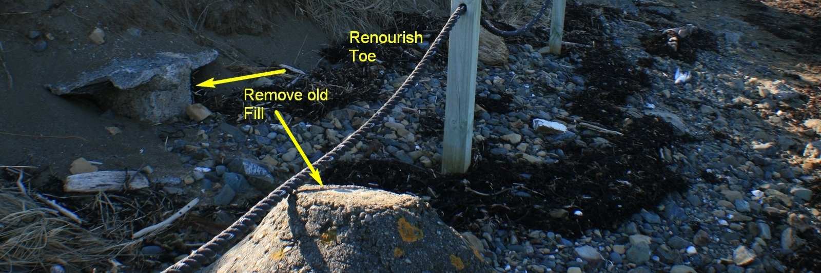
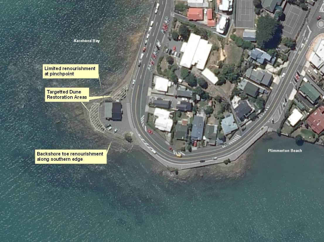 Figure 4:
 Southern edge of the site
Figure 5: Summary of the beach and dune restoration project
6
WGN_DOCS-#1015070-v1