1.
Incident Name
2. Operational Period
SITUATION
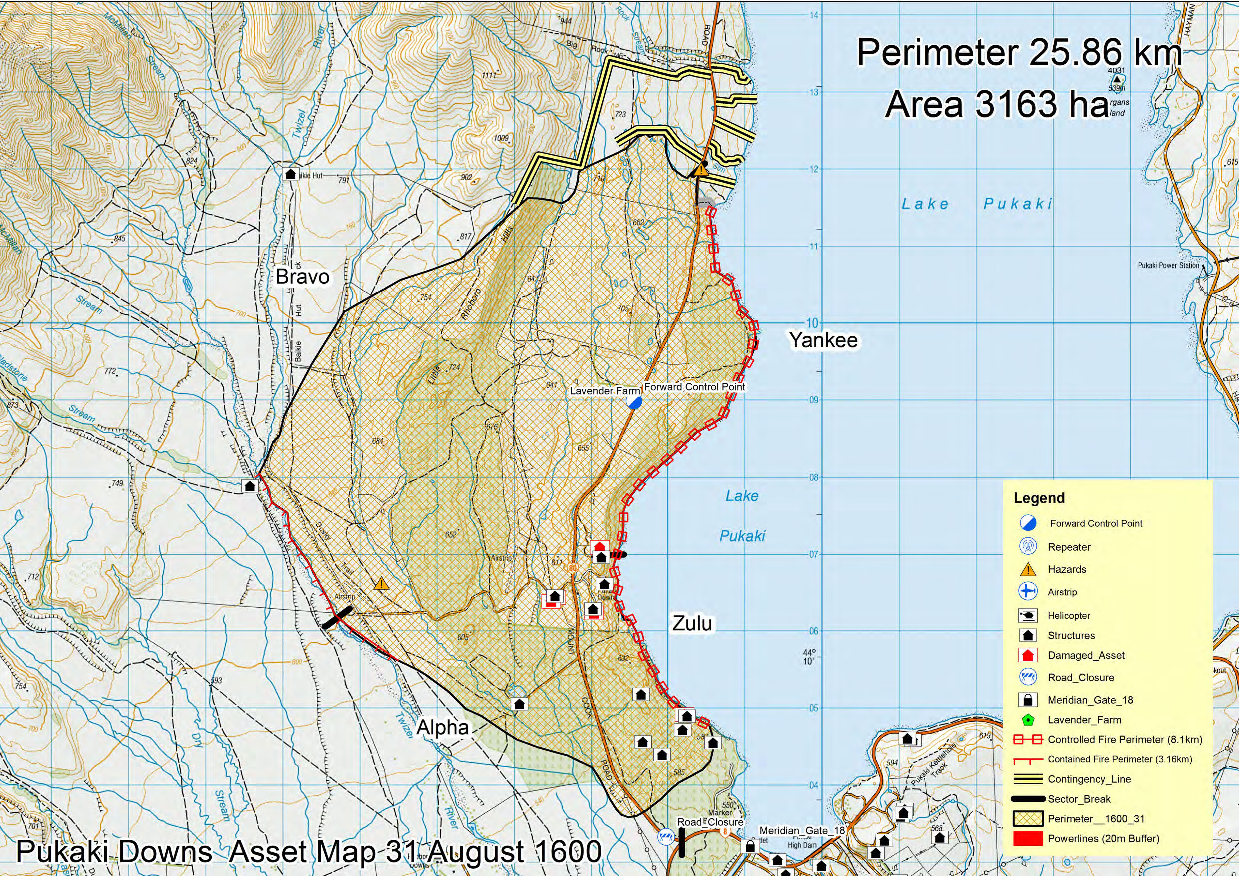
Pukaki Downs Fire
Date 31st August 2020
REPORT
Time
1900hrs
RF201
3. Location
4. Vegetation
5. NZ Topo50 Grid Ref.
Twizel
Forest/Scrub/Grass/Slash/
E1365102
Other:
N5107856
6. Assessment
Fire started in the vicinity of the confluence of the Gladstone and Twizel Rivers along Baikie Hut
track approximately 11.25am and spread rapidly through a mix of tussock grass and wilding pine
fuels.
There are 8 significant residential properties, with multiple structures, affected on the east side
of SH80. One house has been lost, along with a barn and four small outbuildings. Currently
carrying out property protection using ground crews supported by tankers.
Pukaki Scientific Reserve has been extensively damaged.
The fire has continued to spread overnight. Perimeter is approximately 25km and total area of
incident ground is 3163ha
7. Action taken
Multiple ground crews were tasked to work on structure protection and evacuate properties. Air
resources worked on the flanks and structure protection when required. Heavy machinery
engaged to create fire breaks in suitable places around the perimeter. Crews patrolled and
worked on structure protection overnight. Fire break construction on the northern end of the
fire has established extra contingency lines beyond the fire edge. Five excavators and two
bulldozers have worked all day today to reinforce and extend the fire breaks.
Contact has been made and will continue with stakeholders, Landowners, Iwi, Police, LINZ, MPI,
MSD DOC, NEMA, Meridian and Netcon. Managed and supervised access to properties for
residents has been organised and will be implemented through the afternoon if conditions
allow.
under the Official Information Act 1982
Coastguard are on site to provide support on the lake front around the areas where helicopters
are dipping.
Affected property meeting planned occurred at 11.00hrs. Residents were escorted in to four
properties to allow them to get personal items, check on livestock, and assess damage this
afternoon.
Released
Infra Red camera was flown over the fire ground to check around the perimeters of each
dwelling.
A fire investigator, John Foley, has been appointed and will be arriving today.
8. Factors
• Extreme fire behaviour occurring and expected to continue today.
• Power grid control gate 18 threatened. This was potential to have significant effect on
supply of power to whole of South Island. Retardant has been put around the gate 18
structures for protection.
• Powerlines along SH80 are severely damaged. Lines crews have assessed them and are
looking at repair options.
• SH80 – link to Aoraki Mt Cook
and will remain closed overnight
• A convoy will be established to escort vehicles in and out of Mt Cook village at set times
to allow residents and essential services to reach the village
• SH8 – Now open
•
1982
Prime assets – lavender farm and structures
• DOC estate
• Patchy areas within fire area remain unburnt
Act
9. Predicted Incident Development
The fire will continue to burn in heavy wilding pine fuels under strong winds and potentially
extreme fire behaviour conditions. Crews will continue to work on protection of structures.
43% of the perimeter has been confirmed as contained.
Overnight rain and colder weather tomorrow should dramatically reduce fire behaviour allowing
Multi day mop-up and containment using helicopters, heavy machinery and ground crews
Information
10. Prepared by:
Date/Time 31-8-20 1900hrs
Official
the
under
Released
1982
Act
Information
Official
the
under
Released