1982
Act
Movement and Place Classification
Network Classifcation Factors and Measures
Information
Disclaimer: The concepts outlined in this document are to undergo trials with a
representative group of Road Controlling Authorities and may be changed based
Official
on the results of those trials and other feedback received.
the
under
Released
Purpose
1982
The purpose of this document is to present for review, discussion and
agreement the factors measures to be considered for the categorisation of
Act
transport networks into the One Network Framework classification system.
This includes both quantitative measures, numbers of people and tonnage of
goods being moved along a corridor, and the qualitative measures, linking
locations of importance such as ports, schools and commercial precincts.
Background
The One Network Framework project delivered the high level design
concepts for movement and place classification in April 2020. These
concepts were intentionally ‘high level’ and described the overall concepts
Information
that were agreed by a range of transport sector subject matter experts
through a series of design workshops. The published categories included
some indicative categorisation factors and measures that at the time were
indicative only and served to demonstrate the concepts being presented.
The next phase of the project is expanding the high level concepts into a
detailed design of the framework. This includes development, consideration
and agreement of the specifics of each movement, place, modal movement
Official
and street family class, and the methodology of how streets and roads
should be classified.
the
under
Discussion Document - Network Catregorisation
1
Released
Place
1982
Classification of ‘Place’ in terms of definable metrics is not necessarily a
In terms of metric to describe each on-street activity category, this most
particularly easy exercise. The intrinsic value of a place is often invoked
closely aligns with pedestrian activity, thus describing a correlation between
Act
more by feelings than in what could be described by facts. Despite this,
movement and place. On-street activity also creates the need for
numerous academic engineering studies have sought to quantify the value of
pedestrians to cross the carriageway lateral y proportionately, this is
place. Much of this enquiry was in response to the need to classify place
considered through the interaction with movement metric.
and its relationship with movement, in so enabling a movement and place
approach to transport corridor planning and management.
Catchment significance and connection to community
The classification of place should achieve the following outcomes:
At a high level, catchment significance relates to how far people are wil ing to
travel to experience a place. Guidance is provided in terms of the types of
•
Reflect the planned and intended nature of the specific location
facilities that may fall into each class.
•
Relate to the on-street activity generated by adjacent land-use
Adjacent Land-use
•
Consider the interaction with the movement function of the corridor,
including the requirement for lateral movement across the carriageway
Adjacent land-use is a creator of on-street activity and the requirement for
Information
access to and from the corridor. While a range of economic and social
•
Factor in the requirement for access to adjacent land-use from the
indicators, such as GDP and population density, could be used as metrics to
corridor and access to the transport corridor from adjacent land, in terms
categorise place in terms of adjacent land-use, the application of this would
of frequency and regularity.
be cumbersome and require a large amount of data analysis. Land-use
zoning in the TLA’s district plan provides the aspirational intentions for the
•
Be informed by adjacent land-use, and the density of activity occuring
adjacent land as determined by land-use planners.
‘off-street’
Interaction with movement function
•
Recognise the significance of the catchment from which the locationOfficial
attracts visitors, or the location’s importance to the surrounding
As the levels of on-street activity and requirement for access increase, so
community.
does the need for movement laterally across the carriageway. This
Intended nature of place
requirement can be thought of in terms of the frequency of crossing facilities
along the corridor, with the requirement for lateral movement across the
the
The ONF intends to primarily describe the aspirational view of the transport
carriageway increasing in proportion to on-street activity. For M1P5 in the
network and the relationship with adjacent land-use close to the transport
urban context lateral movement wil always be grade separated.
corridor. The intended nature of a place is a brief description of the location
Intensity of use
that in simple language describes the overall nature of the place and is able
to invoke in the mind’s eye what the place may appear like.
Intensity of use is a measure of how much the off-carriageway space is being
under
On-street activity
used, by people dwelling in the space, eating al-fresco, browsing market
stal s, window shopping, or just relaxing on a bench seat. The metric
The level of on-street activity is a direct pointer to the classification of place.
measures how utilised each square metre of public space is over the course
As the level of observable and measurable activity off-carriageway within the
of a day (7am to 5pm).
corridor increases, so does the classification of place, in proportionate steps.
Discussion Document - Network Catregorisation
2
Released
1982
The table overleaf describes how each of the factors described above could
be used for categorisation of place. Once agreed and approved the metrics
in the table would be utilised in a functional classification tool that would form
Act
part of the toolset to assist users in the application of the framework.
The factors described in the table are derived from a number of local and
overseas movement and place frameworks, including those used by
Transport for London, City of Toronto, VicRoads (Victoria, Australia),
Transport New South Wales, and Auckland Transport.
Information
Official
the
under
Discussion Document - Network Catregorisation
3
Released
Place
Classification factors
Metrics
1982
Level of On-Street
Level of On-Street
Interaction with
Intensity of use
Nature of Place
Activity
Indicative Land-Use
Catchment Significance
Activity
movement
Indicative Adjacent Land-Use
Catchment Significance
Residential and Commercial
The intensity of use
Requirement for
Place significance - Activity
of the off-
Pedestrian volume
density:
Act
lateral movement
generating facilities
carriageway space
Land-use zone classification
by persons dwel ing
Regionally Significant Locations:
Land-use generates high
Central Business Districts
levels of on-street activity
On-street facilities
including lateral movement
Very high-density mixed
Airports
Provincial/
encourage use by active
use (high rise apartments
Streetscape provides for a
Aligned to W1
At intersections, and
Central Metro Stations
> 4 Person
P1
across the carriageway.
Metropolitan Centre zone
modes, and visitors to stop
and office towers),
provincial or regional level
> 10
00 /hour (peak)
frequent intermediate
Ports
hours/m2/day (7am to
Regional
Sites of regional
City Centre zone
and experience the locality
significance that attract
downtown retail and
of amenity.
> 5,000 /day
intervals midblock
Hospitals
5pm)
for longer periods.
commercial centres.
Sports Stadiums and Event Arenas
significant visitor numbers
University and Polytechnic Campuses
to the location.
Major tourist destinations
Surrounding land-use
Information
generates significant levels
City/District Significant Locations:
of on-street activity
Diverse mixed use, low rise
At intersections, and
Main Shopping Centres
City/
On-street facilities
Streetscape provides for a
Aligned to W1,W2
High Density Residential Zone
> 2 Person
P2
encourage visitors to stop
including lateral movement
apartments, special zones
city or district level of
infrequent
Commercial zone
Big Box Retail precincts
hours/m2/day (7am to
District
and experience the locality.
across the carriageway.
or high density
amenity.
> 25
00 /day
intermediate intervals
Large Format Retail zone
Transport Interchanges
5pm)
Weekend markets and
commercial/ retail.
midblock
Secondary Schools
special events may also
Main regional tourist attractions
generate peak activity.
Medium Density Residential zone
Neighbourhood Significant Locations:
Surrounding land-use
Neighbourhood Centre zone
Suburban Shopping Centres
Official
generates increased on-
At intersections and
Local Centre zone
Suburban Metro Stations
Medium density residential,
Neighbourhood/
Increasing levels of on-
street activity.
Streetscape provides for a
> 1 Person
Aligned to W2
connecting strategic
Mixed use zone
Primary Schools
P3
mixed use residential/
street activity and access to
Community facilities and
neighbourhood or township
routes (such as
Town Centre zone
Playgrounds
hours/m2/day
Township
commercial, or industrial
adjacent land.
points of interest in rural
> 1000 /day
areas.
level of amenity.
pedestrian alleyways
Light Industrial zone
Sporting Club Grounds
(7am to 5pm)
settings generating some
and cycle paths)
Heavy Industrial zone
Local parks
on-street activity.
Open space zone
District Halls
the
Sport and Active Recreation zone
Places of local interest/colour
Casual with care
Large Lot Residential zone
Quieter streets likely to
Primarily residential or peri-
Mostly low density
within M4 and M5
Low Density Residential zone
urban in nature, with on-
Aligned to W3
movement classes,
< 1 Person
P4
Local
attract some on-street
residential in urban and
Streetscape has local area
General Residential Zone
activity. Generally private
street activity associated
peri-urban areas. Lifestyle
significance.
targeted but
Rural Lifestyle zone (R)
Suburban Residences
hours/m2/day (7am to
with residents going about
< 1000 /day
infrequent within M2
5pm)
low frequency access.
their lives.
blocks in peri-urban areas.
and M3, Grade
Settlement zone (R)
under
separated at M1.
Natural Open Space zone
No pedestrian
Streetscape has local
Movement of people and
Mostly rural, except for
significance in the rural
movement, Walking
P5
Limited
goods the primary function.
Little discernible on-street
Motorways and
context, but does not
may be prohibited
Casual with care
General Rural zone (R)
Rural Environment
Effectively Nil
Limited on-street activity
activity.
Expressways in urban
provide any amenity for on
along corridor, no
Rural Production Zone (R)
and requirement for access.
areas.
street activity
Pedestrian facilities
provided
Discussion Document - Network Catregorisation
4
Released
 Movement of People and Goods
1982
The classification of overall movement should achieve the following
outcomes:
Act
• Recognise the contribution to movement of all modes of transport,
including active modes
• Re-focus on the movement of people and goods along a corridor, not
simply the number of vehicles using the carriageway
• Provide a method for classification that can be both prescriptive and
intuitive. That is, the approximate classification can be derived using
quantitative measures, and refined using qualitative factors
• Feel right when the movement and place classification for the corridor is
compared against the street family that classification places it in, i.e. the
intended function of the corridor is congruent with its movement class.
Information
• Is there a transport function to be considered?
Figure 1: People movement
People movement
Linking locations of significance
A fundamental shift from the One Network Road Classification framework is
Other factors for movement need to be considered, such as the intent of the
the consideration of movement as people and goods, rather than the number
corridor in linking locations of significance. This categorisation factor is
Official
of cars and trucks using a corridor. This approach also better recognises the
known as strategic significance and indicates the importance of the corridor
contribution of other modes to the classification of overall movement.
within the transport network. Factors that contribute to strategic significance
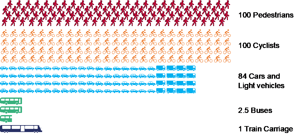
Consider figure 1, if we need to move 100 people along a corridor. This can
include the importance of the start and end points of the journey, usually in
be achieved by 100 pedestrians, or 100 cyclists, or 84 cars and light
terms of their contribution to the economy, access to essential services and
the
vehicles, or 2.5 buses, or just one train carriage. In reality it will be some
the distance between these points, for example inter-regional journeys being
combination of all available modes. The point is that 100 pedestrians
categorised higher than local journeys. Strategic significance is also
walking down a street is as valid a means of movement as 84 cars travelling
designated by network design. This is best demonstrated that in most
down the same street.
instances, there are likely to be more than one possible route to connect two
locations of significance, but only one wil usually be designated as the
strategic corridor for that link.
under
Putting this together with people movement means that a footpath linking a
major transport interchange with a metropolitan centre carrying 30,000
pedestrians a day has a similar rating for movement to an urban motorway.
Discussion Document - Network Catregorisation
5
Released
Movement by mode
1982
General Traffic
Strategic significance
Act
General traffic wil continue to use the 8 levels of classification prescribed by
For general traffic, the strategic significance of each class is implicit, with the
the One Network Road Classification framework.
higher rated classes having greater strategic significance. When classifying
This approach has the following advantages:
general traffic, it wil be important to look at the function the corridor is
intended to provide, and not simply the volume of vehicles it is expected to
• For much of the network, the current ONRC classification can be directly
convey. For example, urban motorways do not have to be capable of
transcribed over to One Network Framework
supporting 35,000 cars per day if their primary purpose is to connect to a
• The ONRC classification methodology for general traffic is well known
strategically important location. Likewise, a rural road that is supporting
throughout the sector
relatively low volumes of traffic could be elevated in status if it is the sole
means of connectivity to a remote region to ensure the corridor receives
• Existing approaches to performance monitoring and reporting for
adequate funding to maintain the appropriate level of resilience.
carriageways can be retained
The significant difference to ONRC is that the One Network Framework is
Information
intended to reflect the aspirational state of the network, i.e. the classification
Generally, the methodology for determining the movement classification of
should reflect how the corridor is expected to operate in the medium to long
the general traffic mode wil continue to utilise the ONRC method, which
term. This coupled with the fact that the categorisation need only consider
includes consideration of traffic volumes, importance of the link (strategic
the General Traffic mode means that some adjustment to the ONRC
significance), and differentiating urban and rural contexts. The AADT metrics
measures to align with strategic significance may be justified.
for each category wil be adjusted to reflect people movement rather than
vehicle movement, therefore allowing for a base comparison with other
Rural / Urban difference
modes and the facility to use simple arithmetic to determine an overall
movement classification based on all modes.
Official
As for the ONRC, the categorisation for General Traffic wil recognise the
difference between streets within urban areas, and rural roads, i.e. the
threshold to be rated in a particular class wil be lower in the rural context
the
than in the urban context.
It is intended that Urban and Rural be dif erentiated based on adjacent land-
use, i.e. if the land the street or road traverses is a rural land-use zone then
the road is rural.
under
Discussion Document - Network Catregorisation
6
Released
General Traffic
1982
ONRC Metric / class
People movement per
Class
ONRC Class
Strategic Significance
differentiator
day
Act
The high volume movement of people nationally or to
GT1
ONRC - High Volume.
nationally significant locations. Nationally significant
Urban > 35,000,
Urban > 40,000,
routes.
Rural > 20,000 VPD
Rural > 25,000 VPD
GT2
ONRC – National
The movement of people nationally or to nationally
Urban > 25,000
Urban > 30,000
significant locations
Rural > 15,000
Rural > 18,000
GT3
ONRC – Regional
Connectors providing significant movement of people
Urban > 15,000
Urban > 18,000
between cities and regions.
Rural > 10,000
Rural > 12,000
Information
GT4
ONRC – Arterial
Connectors providing significant movement of people
Urban > 5,000
Urban > 6,000
through or between neighbourhoods and towns.
Rural > 3,000
Rural > 3,500
GT5
ONRC – Primary Collector
Major collectors that link neighbourhoods to
Urban > 3,000
Urban > 3,500
townships/districts.
Rural > 1,000
Rural > 1,200
GT6
ONRC – Secondary Collector Minor collectors that link local areas to
Urban > 1,000
Urban > 1,200
neighbourhoods.
Rural > 1,000
Rural > 1,200
Official
GT7
ONRC – Access
Movement within a local area or to access areas outside Urban < 1,000
Urban < 1,200
the local area.
Rural < 200
Rural < 250
the
GT8
ONRC – Low Volume
Low volume movement within a local area
Urban < 200
Urban < 250
Rural < 50
Rural < 60
under
Discussion Document - Network Catregorisation
7
Released
Freight
1982
For the reasons stated above under general traffic, the ONRC categories
for Freight are being maintained. For freight, this means there are 7
Act
categories, as ONRC made no distinction between Access and Low Volume
for freight.
Strategic Significance
Generally, the methodology for determining the movement classification of
the freight mode wil continue to utilise the ONRC method, which includes
consideration of vehicle counts, importance of the link (strategic
significance). The AADT metrics for each category wil remain as they are as
they are a proxy for goods movement.
Goods Movement
Information
Converting AADT to goods movement at present is a simple arithmetic
exercise of multiplying the number of vehicles by an assumed average load
size. To date, no work has been done around quantifying the correlation
between tonnage of goods moved and movement of people, and therefore it
is difficult to factor goods movement into overall movement. Strategic
importance of the route for freight, both in terms of volumes of freight able to
be moved and providing links between significant places is still a valid Official
methodology for classifying Freight Movement.
the
under
Discussion Document - Network Catregorisation
8
Released
Freight
1982
ONRC Metric /
Goods Movement
Class
ONRC Class
Strategic Significance
class differentiator
Act
F1
ONRC - High Volume.
The high volume movement of goods nationally or to nationally significant
freight hubs
> 1,200 VPD
> 30,000 tn/day
F2
ONRC – National
The movement of goods nationally or to nationally significant freight hubs
> 800
> 20,000 tn/day
F3
ONRC – Regional
Connectors providing significant movement of goods between cities and
regions.
> 800
> 10,000 tn/day
Information
F4
ONRC – Arterial
Connectors providing significant movement of goods through or between
neighbourhoods and towns
> 300
> 7,000 tn/day
F5
ONRC – Primary
Collector
Major collectors that link neighbourhoods to townships/districts.
> 150
> 3,500 tn/day
F6
ONRC – Secondary
Collector
Minor collectors that link local areas to neighbourhoods.
> 25
> 600 tn/day
Official
F7
ONRC – Access
Freight movement within a local area or to access areas outside the local
area.
< 25
< 600 tn/day
the
under
Discussion Document - Network Catregorisation
9
Released
Public Transport
1982
The classification for Public Transport movement is being developed in
consultation with specialists in PT and multi-modal transport within Waka
Corridor Headway (at peak)
Kotahi. The ONF project wil seek to align with other frameworks and
Corridor Headway is the combined headway of services per hour (at peak)
Act
approaches in general use across the transport sector, and in this case with
that would be observed for all services passing a point on the section of
how PT practitioners view their network. Some views of the PT network do
street being classified. Where the street supports more than one PT service
not correlate directly with how the ONF considers movement and these are
then the corridor headway wil be more frequent than for the individual
outlined in the commentary below. So, for instance, where a classification
services. For example, if two services which both have a 15 minute
factor directly speaks to streetscape design, this wil be excluded from
headway at peak (4 services per hour) utilise the same street for part of their
inclusion in the ONF.
route, the effective the effective corridor headway would be 8 services per
hour along that section of street. Corridor headway then is an indication of
Public Transport Service Level descriptor
the total demand on the street section by public transport. Corridor headway
The service level descriptor wil be included in the ONF as it underpins the
will increase as PT routes get closer to central business districts and key
cornerstone concept of the ONF of creating a common language for use
transport interchanges.
across all disciplines within the transport sector. The descriptor is a useful
Metro Rail
Information
short-form label for each of the PT classes that quickly invokes the nature of
the PT service or route.
By definition, all Metro Rail lines would be classified as PT1 as they are
considered rapid transit corridors irrespective of headway, availability and or
Distinguishing between PT Services and Movement Corridors
volume of people movement. For this reason, all Metro Rail services are
described in Corridor Headway as PT1.
In order to standardise the contribution of public transport to the movement
function of a corridor, the distinction needs to be made between a Public
People Movement
Transport Service and Public Transport use of a corridor. A PT service has
Official
attributes such as headway (the regularity of a particular service), and
Public transport is a very efficient means of moving people, with a fully laden
service start and end points, that do not apply to the corridor. A corridor may
44 seat bus equating to at least 35 private motorcars, even more efficient for
also support more than one PT service, so the cumulative result of all
higher occupancy PT vehicles like double-decker buses that are becoming
services using a corridor wil be what defines the PT movement
increasingly common in NZ. ONF is concerned with people movement rather
the
categorisation.
than traffic volumes. Using the movement of people or freight along a
corridor over a period of time (standardised to daily counts) also allows for
Strategic Significance
direct comparisons across transport modes in their contribution to transport
outcomes.
Strategic significance describes the extent to which the particular corridor
contributes to the Public Transport Network. For PT this ranges from
School Buses
dedicated corridors that support mass rapid transit to corridors where low
under
volumes of targeted PT services operate.
School buses can be included within the classification consideration of a
particular corridor if the route the school bus takes is shared with other public
transport services. If the route is only used for school buses, then the
corridor would be classified as targeted.
Discussion Document - Network Catregorisation
10
Released
Public Transport
1982
Public
Transport
Strategic Significance
People Movement
Class
Service
Corridor Headway
(Indicative)
Description
Act
Level
(Role in Public Transport Network)
(At peak)
(Bi-directional)
descriptor
Dedicated public transport corridors provide for the fast
and efficient long distance movement of people by rapid
Corridors where
‘rapid transit’ services are
transit. By definition, they include dedicated busways
PT1
Dedicated
operated, providing a fast, frequent, highly
Buses > 40 services per hour
and al metro rail lines. They are mode exclusive, only
reliable, and high capacity form of urban
Rail > All Metro services
> 5000 per day
providing facility to support public transport (excepting rail
transport along a
dedicated PT corridor.
lines that can also provide a goods movement function
under the freight mode, but which is exclusive use by one
or the other at a time).
Corridors where many frequent services
Spine corridors are where many inbound services come
operate and
many different bus services
together or outbound services originate, usually within
Information
merge together to create very high
city centres or at major transport interchanges, and much
PT2
Spine
frequencies and overall passenger
> 12 bus services per hour
1000 to 10000+ per day of the street space can be dedicated to public transport
movement. Any deficiencies on these
infrastructure, including significant space utilised for bus
corridors affect multiple services and large
stops. Examples are Symonds Street in Auckland central,
parts of an urban area.
and Manners Street in Wellington. The Auckland Harbour
Bridge would also be considered a Spine corridor.
Corridors where
frequent public transport
Primary public transport corridors occur on the parts of
Official
services operate, providing regular
the network where frequent service can be expected.
PT3
Primary
(generally at least once every 15 minutes)
> 4 bus services per hour
500 to 2000 per day
This could be for part of route where the col ection of
services across most of the day, seven days
services operating results in a better than 15 minute
a week.
headway frequency of that part of the route. These
corridors are more likely to be on major arterial roads.
the
Corridors where
PT services operate at
most times of day, but less frequently. The
Secondary public transport corridors occur in the parts of
PT4
Secondary
main focus of PT services using these
< 4 bus services per hour
100 to 1000 per day
the network providing local access and coverage, but at
corridors is to provide basic access and
reduced schedules. Routes typically traverse local
coverage.
streets and minor arterial roads
Corridors where services only operate at
These services provide a basic level of access to public
under
PT5
Targeted
some times of the day (e.g. peak only) or for
transport, but on a much reduced schedule, typically only
specific trip purposes (e.g. school buses
N/A
< 100 per day
once a day return, such as school bus services, and long
only).
distance commuter services, or at peak times only.
Note: Not all classes of Public Transport wil be applicable to all RCAs. It is expected that only large metropolitan councils will likely have corridors rated as PT1. Some smaller authorities also may not have corridors
that would have the required frequency of operation or level of people movement to be classed as PT2 or even PT3.
Discussion Document - Network Catregorisation
11
Released
Cycling
1982
The project team is collaborating with active mode subject matter experts
PIKB Definition
within Waka Kotahi and the transport sector to co-design and develop out the
base guide shown in the table overleaf, including any metrics required to
The current definitions for primary and secondary cycle networks from the
Act
assist with classification. The proposed categorisation structure as it is
Planning and Investment Knowledge Base (PIKB) have been included to
specified overleaf is at the point where the working group for active modes
give additional guidance. It should be noted that the definitions are from a
were in agreement that it can be tested with RCAs.
relatively old version of the NLTP assessment framework. A scan of the new
IDMF documentation did not discover any updated definitions, however it is
Strategic Significance
recommended that alignment is sought between the two frameworks on
definitions of strategic cycling networks.
For cycling primarily within the urban realm, there are currently 3 suggested
classes (C1 to C3) comprised of two classes for the primary and secondary
strategic cycle networks and the third class being the ‘everything else’
category. The three classes are intended for utility cycling, i.e. cycling done
for the purpose of getting to an activity at the journeys end and therefore for
the purpose of transport.
Information
Proposed class C4 is intended for cycling that is not intended for utility
cycling, that being cycling for recreational and tourism purposes and
predominantly in the rural context. This recognises the significance of
infrastructure such as the NZ cycle trail and allows for these routes to be
daylighted in overall cycle network planning, including their influence in
generating the requirement for movement and access. This class of cycling
Official
is conceptual only and requires review by active mode SMEs as to whether it
should be included.
People Movement (indicative)
the
Compared to all other modes of transport, cycling has relatively low
thresholds defining each class. Only the busiest primary cycle routes in
Auckland and Christchurch exceed 1000 movements per day. As such,
cycling is unlikely to ever be a significant contributor to overall movement in a
corridor except for routes such as cycleways or shared paths. The people
under
movement numbers are indicative only with classification of active mode
networks starting with determining the strategic networks (primary and
Secondary) for the mode.
Discussion Document - Network Catregorisation
12
Released
1982
Cycling
People Movement
Class
Strategic Significance
PIKB definition
Description
Act
(Indicative)
A primary corridor is the highest classification level
route in a cycling strategic network that carries the
The primary strategic cycle network provides the backbone of the overall cycle network catering for higher volumes of
C1
Primary strategic cycling network, intended to
cycle movement, longer and more efficient journeys (connecting across townships or between suburbs), and connecting
support high volumes of cyclist movement
> 500 /day
largest volume of cyclists and has the greatest potential
to attract cyclists. Primary corridors provide for trips
to key locations of employment and education. Primary cycle networks wil usual y be dedicated cycle paths or cycle
across town and between suburbs.
lanes to allow for efficient journeys.
A secondary corridor is an identified component of a
Secondary strategic cycling network, providing
cycling strategic network that connects potential users
The secondary strategic cycle network provides the col ector function within the network, joining local streets and roads
C2
key connections to schools, community facilities, > 100 /day
to the primary corridors. Secondary corridors provide
to the primary strategic cycle routes. They also support key local cycle movement providing connections to Schools,
or employment.
for trips across suburbs or between destinations (i.e.
local shopping centres, and suburban workplaces. Typical y occurring on higher volume connector roads, secondary
schools, workplaces).
networks generally share the carriageway with vehicular modes.
Information
This class covers all other routes that could support cycling not identified as primary or secondary strategic networks.
Every other street or path that supports cycling
On-street cycling along quiet residential streets where the volume and average speed of traffic means a relatively safe
but is not part of the strategic cycling network.
environment for cycling, as wel as along busy urban arterials where no special al owance for cycling has been made and
C3
Localised cyclist movement along and across
< 100 /day
the cyclist must share the road with care. This class also includes any off-road routes, such as paths through parks
residential streets, first/last kilometre to provide
where cycling is permissible. Normally little or no specific interventions are used to support cycling on these routes.
link to primary and secondary cycling networks.
The type of journey undertaken on these routes is primarily utility cycling for the purpose of getting to an activity at the
journeys end.
Official These routes occur mostly in the rural context and are used for cycling activity that is undertaken for the purpose of
Special rural routes used primarily for recreation
recreation or tourism, i.e. to experience the journey rather than to reach the destination, and therefore not utility
C4
or tourism (Less of a transport journey function).
cycling. These routes include al the off-road section of the NZ cycle trail, as well as the touring stages of that network,
NZ Cycle trails. Excludes specialist cycling
the pieces of the road network that provide link between the off-road portions. This class can also be used for routes
facilities such as mountain bike parks.
known to be popular as training circuits with road cyclists. Excluded from this class and from inclusion in the cycle
the
network overall are specialist cycling facilities such as mountain bike parks.
under
Discussion Document - Network Catregorisation
13
Released
Walking
1982
The project team is collaborating with active mode subject matter experts
PIKB Definition
within Waka Kotahi and the transport sector to co-design and develop out the
base guide shown in the table overleaf, including any metrics required to
The current definitions for primary and secondary walking networks from the
Act
assist with classification.
Planning and Investment Knowledge Base (PIKB) have been included to
give additional guidance. It should be noted that the definitions are from a
relatively old version of the NLTP assessment framework and are probably
Pedestrians are also a significant contributor to the place value of a road or
more relevant to cycling than walking. A scan of the new IDMF
street, generating on-street activity that interacts with vehicle movement
documentation did not discover any updated definitions, however it is
where lateral movement is undertaken. Pedestrian volumes also contribute
recommended that alignment is sought between the two frameworks on
to the nature of place by creating a sense of community where there are
definitions of strategic walking networks.
significant numbers of people using the street. Further information is
contained within the Street Families section of this document on the
contribution of pedestrian move to the nature of place, and how that would
be observed in the various Movement/Place classifications of the street
families.
Information
Strategic Significance
For walking primarily within the urban realm, there are currently 3 suggested
classes (W1 to W3) comprised of two classes for the primary and secondary
strategic walking networks and the third class being the ‘everything else’
category. The three classes are intended for walking undertaken for the
purpose of getting to an activity at the journeys end and therefore for the Official
purpose of transport.
Proposed class W4 is intended for walking that is undertaken for recreational
the
and tourism purposes and predominantly in the rural context. This
recognises the significance of infrastructure such as Te Araroa and
Department of Conservation tracks, and allows for these routes to be
daylighted in overall walking network planning, including their influence in
generating the requirement for movement and access. This class of walking
is conceptual only and requires review by active mode SMEs as to whether it
under
should be included.
People Movement (indicative)
The people movement numbers are indicative only with classification of
active mode networks starting with determining the strategic networks
(primary and Secondary) for the mode.
Discussion Document - Network Catregorisation
14
Released
Walking
1982
People Movement
Class
Strategic Significance
(Indicative)
PIKB definition
Description
A primary corridor is the highest classification level route in a
Act
walking strategic network that carries the largest volume of
The primary strategic walking network provides the backbone of the overall walking network catering for
W1
Primary strategic walking network, intended to
higher volumes of pedestrian movement, more efficient journeys, and connecting key locations of
support high volumes of pedestrian movement > 5,000 /day
pedestrians and has the greatest potential to attract new
pedestrians. Primary corridors provide for trips across town
employment and education to transport hubs . Primary walking networks will usually provide for pedestrian
and between suburbs.
priority over other transport modes.
A secondary corridor is an identified component of a walking
Secondary strategic walking network, providing
strategic network that connects potential users to the
The secondary strategic walking network provides the col ector function within the network, joining local
W2
key connections to schools, community
> 1000 /day
primary corridors. Secondary corridors provide for trips
streets and roads to the primary strategic walking routes. They also support key local pedestrian movement
facilities, or employment.
across suburbs or between destinations (i.e. schools,
providing connections to schools, local shopping centres, and suburban workplaces. These routes are likely to
workplaces).
have footpaths engineered for increased volumes than those on residential streets.
Every other street or path that supports
This class covers all other routes that could support walking not identified as primary or secondary strategic
walking but is not part of the strategic walking
networks. This class also includes any off-road routes, such as paths through parks where walking is
W3
network. Localised pedestrian movement along
undertaken for the purpose of getting to an activity at the journeys end. At a minimum these routes should
Information
and across residential streets, first/last
< 1000 /day
have a formed footpath for use by pedestrians. Localised walking trips along and across residential streets,
kilometre to provide link to primary and
connecting to locations of local significance, and first/last kilometre to provide link to primary and secondary
secondary walking networks.
walking networks.
Special rural routes used primarily for
These routes occur mostly in the rural context and are used for walking activity that is undertaken for the
W4
recreation or tourism (Less of a transport
purpose of recreation or tourism, i.e. to experience the journey rather than to reach the destination. These
journey function). Te Araroa, DoC tracks.
routes include all Department of Conservation walking tracks, and Te Araroa.
Official
the
under
Discussion Document - Network Catregorisation
15
Released
Street Families
1982
Street families bring together the movement and place elements to
Description
determine an overall movement and place classification for the road or
Act
street. In order to limit the number of possibilities within the framework,
The descriptions of each street family describe the general characteristics of
street families comprise of regions within the movement and place grid. As
the street family in terms of the levels of movement, the amount of on-street
an evolution of ONRC framework the objective of the street family classes is
activity, and indicative adjacent land-use. The provide a summary of all the
still to ensure consistent infrastructure funding and as a means for
classification factors for the specific family.
comparative analysis across the entire land transport network in New
Zealand.
Nature of Place
The street families are designed to be intuitive, so that as a first pass when
The three significant factors that make up the place classifications the street
thinking about the corridor under consideration a particular street family is
family spans are described here, with some additional depiction of the
envisioned in the mind’s eye of those undertaking the classification. This is
specific character for the particular street family.
then checked against what the metrics and factors are indicating an
appropriate classification for the corridor should be.
On-street activity
Information
Two sets of street families are provided, one for use in the urban realm and
For the specific street family this describes what a casual observer would
one for rural. This recognises that both the level of people and goods
experience in terms of the level of activity along and across the street and
movement for a particular class, and the factors that designate place are
some indication of the opportunity for lateral movement.
different for each context.
Adjacent land-use
Name
Describes the nature of the adjacent land-use that is generating the
Each street family name suggests the nature of a particular road or street
requirement for access to the corridor, and therefore contributing to on-street
Official
when both the level of movement of people and goods and the nature of the
activity and generating movement. The density of residential or commercial
place are factored into the classification. They will form part of the common
properties adjacent to the corridor is also stated.
language to be used when referring to similar classes of streets and roads
and be easier to remember that technical alphanumeric codes like M2P3.
Street Family Classification matrix
the
Street Families can also undertake additional functions that are not
The current configuration of the street family zones overlaid on the
immediately invoked by the Street Family name, and which would appear to
movement and place matrix is shown overleaf. The colours used are those
be completely different from each other in both function and form, but have in
being recommended for use on maps and within GIS systems to provide
common similar levels of movement and place significance. An example of
contrast between different classes likely to appear adjacent to each other.
this is industrial areas when compared to Local Streets and Urban
The colours have also been chosen to provide colour contrast for people with
Connectors, where the amount of activity defining the place component is
the common forms of colour blindness.
under
similar, and the level of people and goods movement is comparable.
Discussion Document - Network Catregorisation
16
Released


1982
Rural
UrbanAct
M1
National
Transit
Urban
Highways
M1
City Hubs
Corridors
Connectors
M2
M2
Main Streets
Rural
Information
Connectors
M3
Stopping
Activity
M3
ement
Places
ement
Streets
Peri-urban
Mov
Roads
Mov Official
M4
M4
Rural
the
Local Streets
Roads
M5
M5
Civic
Spaces
under
P5
P4
P3
P5
P4
P3
P2
P1
Place
Place
Discussion Document - Network Catregorisation
17
Released
Street Families
1982
Name
Description
Nature of Place
Urban
On-street Activity
Adjacent Land-use
Local Streets provide quiet and safe residential access for all ages and abilities and foster community spirit and local pride. They are part
Low levels of on-street activity associated with residents going
Act
of the fabric of our neighbourhoods, where we live our lives and they facilitate local community access.
about their daily lives. Due to the low levels of vehicle movement,
Local Streets Their local Place significance derives from the on-street activity being associated with those who live on these streets. Movement
lateral movement can be undertaken at any point along the
classification is low with most trips local y generated.
corridor to coincide with desire lines. In some particularly quiet
Primarily suburban low density residential use.
Local Streets are the most common and most diverse streets in urban areas. They are generally important components of walking and
streets the carriageway can often be used as a play area by local
cycling networks and should support these transport choices for local trips.
children.
Urban Connectors provide safe, reliable and efficient movement of people and goods between regions and strategic centres and mitigate
the impact on adjacent communities.
These streets have a lower Place classification associated with the reduced level of on-street activity and resulting from the adjacent land
Low to medium density residential and commercial use. Some
Urban
use. The higher Movement classification indicates that the street may be an important route for freight, public transport, private vehicles Low levels of on-street activity associated with people needing to
or cyclists.
pass through an area. Requirement for lateral movement usually
routes provide for main connectors through industrial areas.
Connectors The purpose of Urban Connectors is to provide for efficient movement of people and goods from A to B. There are low levels of
confined to intersections with adjoining streets.
Servicing adjacent land has a lower priority, as the key role of
interaction between the adjacent land use and the street. Separation between modes is likely to be required as speeds and volumes tend
these streets is to move along them.
to be higher. Servicing adjacent land has a lower priority, as the key role of these streets is to move along them rather than accessing
adjacent properties. Industrial area streets are also most likely to fall within the Urban Connectors family.
Information
Activity Streets provide access to shops and services by all modes. There is significant demand for movement as wel as place with a need
Activity
to manage competing demands within the available road space. Activity Streets aim to ensure a high quality public realm with a strong
Increased levels of on-street activity associated with the
focus on supporting businesses, traders and neighbourhood life. Activity streets are where people spend a significant amount of time,
requirement for access to adjacent stores, businesses and
Moderate density of commercial, retail or industrial activities or
Streets
working, shopping, eating, residing, and undertaking recreation. Examples range from neighbourhood shopping centres to waterfront
community facilities.
medium to high density residential properties
esplanades.
Civic Spaces are roads and streets with high demand for pedestrian activity combined with a much lower requirement for vehicle
movement. They are places communities value, and intended for visitors to enjoy.
These are spaces that people are encouraged to spend time in, and where people on foot can relax and move freely. There is usual y
High levels of on-street activity. These spaces provide pedestrian
Community based facilities that bring people together. Sports
Civic Spaces street furniture and other amenities to encourage and support people lingering and spending time in these spaces.
arenas, concert venues, theatres, parks, restaurants and bars
These streets have a higher Place classification representing the increased level of on-street activity and adjacent land use generating that priority over vehicle movement. Civic spaces al ow for safe lateral particularly those providing al-fresco dining. Tertiary education
Official
activity. The lower Movement classification indicates that these streets are mainly intended for localised on-street activity with little or no movement at any point along the route.
campuses, tourist attractions
through movement. The lateral movement of pedestrians is usual y given priority in these spaces. Examples include pedestrianised
streets, plazas and low speed shared streets.
Main Streets provide a pedestrian friendly environment. They aim to support businesses, on-street activity and public life while ensuring
High levels of on-street activity associated with the requirement
the
Main Streets excel ent connections with the wider transport network. While not having the level of through movement of City Hubs, they provide a
for access to adjacent stores, businesses and community facilities. Diverse mixed use, low rise apartments, special zones or high
similar function, needing to balance the interaction between people and goods movement and on-street activity. Examples include rural
The requirement for lateral movement is tempered by the need to density commercial and retail.
townships and provincial cities where the main through road also doubles as the main commercial centre.
support increased levels of traffic movement.
City Hubs are dense and vibrant places that also have a high demand for people movement. They are also places providing focal points for
businesses and culture. These Streets should aim to reduce the impact of high traffic volumes while accommodating high pedestrian
numbers, multi-modal journeys and access to public transport and essential emergency services.
Highest levels of on-street activity associated with the
These streets have both a higher Place and Movement classification. They are busy spaces with lots of activity from people visiting the
requirement for access to adjacent stores, businesses and
City Hubs
location due to the adjacent land use activity, and a high amount of through movement of people travel ing by all modes.
community facilities, and generated by the high density residential Very high density office and residential tower blocks, central city
The large number of competing demands within City Hubs require careful consideration to ensure that this competition between the
and commercial adjacent land-use. To provide a safe environment shopping malls. Central business precincts of major cities.
under
significant Movement and Place functions is managed. These streets have a high number of people moving through and across them and
for lateral movement, regular control ed crossing opportunities
so require efficient modes of transport, and lateral movement access to be prioritised to mitigate the impacts of congestion, and ensure a are usually required.
safe environment.
Examples include major city centre streets such as Queen Street in Auckland and Lambton Quay in Wel ington.
Transit Corridors provide for the fast and efficient long distance movement of people and goods on within the urban realm. This includes
Transit
motorways and urban expressways. They are mode specific and use by other modes than those intended is discouraged or even
Active modes of transport are specifical y excluded from using
These corridors can traverse the entire range of urban land-use
zones. As there is no provision for access, adjacent land-use is not
Corridors
prohibited. By definition all dedicated, high movement and mode specific transport corridors such as heavy rail networks and busways
these corridors
are included in this classification.
a generator of a requirement for access.
Discussion Document - Network Catregorisation
18
Released
Name
Description
Nature of Place
1982
Rural
On-street Activity
Adjacent Land-use
Local Roads primarily provide access to rural land, for those that live there, and in support of the land-use activity being undertaken. Local
Roads are the most common and most diverse roads in rural areas. They have no appreciable on-street activity occurring and in many
These corridors usually demonstrate no discernible on-street
activity, as no provision is made to support pedestrian
Usually zoned rural production or general rural. The vast range
Act
Rural Roads parts of the country are unsealed. Some rural roads are important for freight, col ecting dairy and forestry products from their source,
of agricultural, horticultural, vinicultural, forestry and other
while others, where volumes of vehicular traffic are very low, can provide safe and pleasant recreational and tourism routes, including the movement. Some casual use of roadsides is made for localised
productive land uses. National parks and other non-productive
New Zealand Cycle Trail and Te Araroa (New Zealand’s walking trail). In some parts of New Zealand, rural roads are utilised more by horses movement. On occasion, the corridor may be used for activities
natural areas
than by vehicles.
such as mustering stock.
These corridors usually demonstrate no discernible on-street
Usually zoned rural production or general rural. The vast range
Rural
Rural connectors provide the link between local roads and national highways. They support an increased level of through traffic, while
activity, as no provision is made to support pedestrian
also providing access from the adjacent land they pass through. Examples include feeder roads into townships and roads to regional y
movement. Some casual use of roadsides is made for localised
of agricultural, horticultural, vinicultural, forestry and other
Connectors
significant tourist attractions.
movement. On occasion, the corridor may be used for activities
productive land uses. National parks and other non-productive
such as mustering stock.
natural areas
Adjacent land-use is residential on larger lot properties and
Peri-Urban
Peri-urban Roads primarily provide access from residential property on the urban fringe, where the predominant adjacent land-use is
Low levels of on-street activity associated with residents going
residential, but usually at a lower density than that found in urban residential locations. On street activity is discernible and local in nature about their lives. Some activity associated with first/last
lifestyle blocks. Nearer urban areas and in small hamlets and
Roads
but also at lower levels than in urban areas. The level of movement on peri-urban roads can range from low volume through to regional.
kilometre of trips to and from adjacent urban areas.
settlements the size of properties may reduce to appear almost
urban in nature.
Increased on-street activities, usual y for a short section of
Stopping Places are where people gather in a rural setting. There is adjacent land-use generating on-street activity, and lateral movement corridor to access key designations immediately adjacent to and
Information
Stopping
across the carriageway can be expected. They have levels of on-street activity or adjacent land-use generating activity that is above the
accessed from the corridor. Can occur on routes of any
Special use areas such as rural schools, community halls, marae
Places
level normally generated by local residents, for example, rural schools, community halls, marae, and sites of scenic interest. The
movement class. Some type of intervention is usually required
and tourist attractions.
movement classification around Stopping Places covers the entire range from M5 to M1.
on the higher movement corridors to ensure safe and efficient
access.
These corridors usually demonstrate no discernible on-street
Usually zoned rural production or general rural. The vast range
National
National Highways provide safe, reliable and efficient movement of people and goods between regions and strategic centres in a rural
activity, as no provision is made to support pedestrian
context. The focus of National Highways is to provide for efficient movement of people and goods from A to B over significant distances,
movement. Some casual use of roadsides is made for localised
of agricultural, horticultural, vinicultural, forestry and other
Highways
and therefore these roads wil usually have reduced land use access along them, many being designated as Limited Access Roads (LARs).
movement. Some C4 level cycling activity is possible on routes
productive land uses. National parks and other non-productive
that connect the NZ cycle trail, or by cycle tourists.
natural areas
Official
the
under
Discussion Document - Network Catregorisation
19
Released
1982
Approach to classification
Act
Classification of streets and roads is undertaken to:
This means placing more weight on the classification factors such as
strategic significance, and how a street or road will provide for the economic
•
Provide the means for describing the various components of the
transport network based on their intended purpose and function
and social outcomes being sought through providing transport connections to
important destinations or providing liveable community spaces, and less on
•
Ensure the provision of consistent service levels on similar function roads
the quantitative metrics
•
Recognise that the various classes of streets and roads provide differing
levels of utility within the transport network
•
Differentiate service performance aspiration by class
•
Guide planning, operation and investment decisions
Information
•
Aid in understanding the function and characteristics of different
corridors, and the service outcomes which can be expected from users
of that corridor
•
Allow for comparative analysis and benchmarking of the performance of
transport networks across RCAs and the country.
In order to achieve all of these desired outcomes it is important that the Official
classification framework is applied consistently across the country within all
Road Controlling Authorities.
Usually a blunt instrument like rigorously defined metrics for each class
the
would be used and enforced so that consistency was almost assured. This
approach does not work as well when considering the aspirational view of
the network, i.e. what the network may look like in 10 years’ time, as any
numbers assigned to factors such as people movement wil be predictive
only.
There is a desire to build a framework that is easy to use, intuitive, and
under
avoids being overly prescriptive. With Street Family classification in
particular, it is recommended the approach be to determine the function of
the road or street first, and then if appropriate adjust the classification based
on metrics.
Discussion Document - Network Catregorisation
21
Released

1982
Act
Information
Official
the
under
Released
Document Outline