


22 March 2021
Zain Khan
FYI request #14838
By email: [FYI request #14838 email]
OFFICIAL INFORMATION ACT REQUEST 3 MARCH 2021
Dear Mr Khan
1. We write in response to your OIA request which was received by email on 3 March
2021. You requested the following information:
Q
1. How many air traffic control sectors are managed by Airways, what are their identifier names,
callsigns and relevant frequencies utilised by them?
Q2. What does the radar screens for these sectors look like? I understand the Lockheed Martin Skyline air
traffic management system is used for domestic airspace and a CAE Oceanic system is used for oceanic
airspace control ed in Auckland.
Q3. Of the aircraft tracks on radar, what information is displayed on their tags attached to the radar
track?
Q4. What shapes are the aircraft tracks on radar when they come within primary, secondary or ADS-B
radar?
Q5. What symbols are used to display airports, VORs, NDBs and RNAV fixes on the radar screens?
Q6. What colour is the background on the radar screens and do they differ for each position in control
towers or area control centres?
Information provided
2. We advise that we are providing the information you have requested. This
information is enclosed in the schedule of this letter.
You are entitled to apply to the Ombudsman for a review of this decision pursuant to
section 28(3) of the Act.
Yours sincerely,
Rachael Choy
Legal Counsel
Airways
Level 2 | 6 Leonard Isitt Drive
Auckland Airport | Auckland
2022
PO Box 53093 | Auckland Airport
Auckland 2150 | New Zealand
Phone +64 9 257 7500


 Schedule
Q1. How many air traffic control sectors are managed by Airways, what are their identifier names, cal signs and
relevant frequencies utilised by them?
Sector Name
Location
Callsign
Frequency
(mHz)
1. Oceanic Radar
Auckland
Auckland Control
123.9
2. Oceanic
Auckland
Auckland Oceanic
HF
3. Auckland Approach
Christchurch
Auckland Approach 124.3
4. Raglan
Auckland
Auckland Control
126.0
5. Bay Approach
Christchurch
Bay Approach
119.5
6. Taranaki
Christchurch
Christchurch
123.7
Control
7. Ohakea Approach
Christchurch
Ohakea Approach
125.1
8. Ohakea Area
Christchurch
Ohakea Control
126.2
9. Wellington Approach
Christchurch
Wellington
119.3/122.3
Approach
10. Kaikoura
Christchurch
Christchurch
129.4
Control
11. Christchurch Approach
Christchurch
Christchurch
120.9/126.1
Approach
12. South
Christchurch
Christchurch
129.3/128.1
Control
13. Queenstown Approach
Christchurch
Queenstown
125.75
Approach
14. Auckland Tower
Auckland
Auckland Tower
118.7
15. Hamilton Tower
Hamilton
Hamilton Tower
122.9
16. Tauranga Tower
Tauranga
Tauranga Tower
118.3
17. Rotorua Tower
Rotorua
Rotorua Tower
121.2
Airways
Level 2 | 6 Leonard Isitt Drive
Auckland Airport | Auckland
2022
PO Box 53093 | Auckland Airport
Auckland 2150 | New Zealand
Phone +64 9 257 7500


 18. Gisborne Tower
Gisborne
Gisborne Tower
127.3
19. Napier Tower
Napier
Napier Tower
124.8
20. New Plymouth Tower
New
New Plymouth
124.7
Plymouth
Tower
21. Ohakea Tower
Ohakea
Ohakea Tower
134.5
22. Palmerston North Tower
Palmerston
Palmerston Tower
120.6
Nth
23. Wellington Tower
Wel ington
Wellington Tower
118.8
24. Paraparaumu Flight Service
Paraparaumu Paraparaumu
118.3
Information
25. Nelson Tower
Nelson
Nelson Tower
127.4
26. Woodbourne Tower
Woodbourne Woodbourne Tower 122.8
27. Christchurch Tower
Christchurch
Christchurch Tower
118.4
28. Dunedin Tower
Dunedin
Dunedin Tower
120.7
29. Queenstown Tower
Queenstown
Queenstown Tower 118.1
30. Invercargil Tower
Invercargil
Invercargil Tower
118.5
31. Milford Sound Flight Service
Milford
Milford Information 118.2
Sound
18. Gisborne Tower
Gisborne
Gisborne Tower
127.3
19. Napier Tower
Napier
Napier Tower
124.8
20. New Plymouth Tower
New
New Plymouth
124.7
Plymouth
Tower
21. Ohakea Tower
Ohakea
Ohakea Tower
134.5
22. Palmerston North Tower
Palmerston
Palmerston Tower
120.6
Nth
23. Wellington Tower
Wel ington
Wellington Tower
118.8
24. Paraparaumu Flight Service
Paraparaumu Paraparaumu
118.3
Information
25. Nelson Tower
Nelson
Nelson Tower
127.4
26. Woodbourne Tower
Woodbourne Woodbourne Tower 122.8
27. Christchurch Tower
Christchurch
Christchurch Tower
118.4
28. Dunedin Tower
Dunedin
Dunedin Tower
120.7
29. Queenstown Tower
Queenstown
Queenstown Tower 118.1
30. Invercargil Tower
Invercargil
Invercargil Tower
118.5
31. Milford Sound Flight Service
Milford
Milford Information 118.2
Sound
Airways
Level 2 | 6 Leonard Isitt Drive
Auckland Airport | Auckland
2022
PO Box 53093 | Auckland Airport
Auckland 2150 | New Zealand
Phone +64 9 257 7500


 Q2. What does the radar screens for these sectors look like? I understand the Lockheed Martin Skyline air traffic
management system is used for domestic airspace and a CAE Oceanic system is used for oceanic airspace
controlled in Auckland.
Correct. Picture of BARCO monitor below, used for all domestic radar sectors.
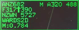
Q3. Of the aircraft tracks on radar, what information is displayed on their tags attached to the radar track?
Listed below, in a basic layout. Picture included below as an example (not al text shown)
Alerts (EMG/Conflict/Airspace/Terrain)
Cal sign, Wake Turbulence category, Aircraft type, Ground Speed, Flight owner(sector)
Current Altitude/Flight Level, Cleared Altitude/FL, Selected FL (in aircraft)
Destination, Squawk code, X-Note (free text note function)
STAR clearance. RTA (Required Time of Arrival)
Indicated Airspeed.
Q4. What shapes are the aircraft tracks on radar when they come within primary, secondary or ADS-B radar?
Unidentified Primary targets are displayed as Circles.
Secondary and ADS-B targets are displayed as either triangles or pentagons. Triangles for approach sectors, within
60nm of a radar head, Pentagons for all other radar sectors.
Q5. What symbols are used to display airports, VORs, NDBs and RNAV fixes on the radar screens?
Airways
Level 2 | 6 Leonard Isitt Drive
Auckland Airport | Auckland
2022
PO Box 53093 | Auckland Airport
Auckland 2150 | New Zealand
Phone +64 9 257 7500


Aerodromes, navigational aids and GNSS waypoints are all displayed as small triangle symbols.
Q6. What colour is the background on the radar screens and do they differ for each position in control towers or
area control centres?
The background of the radar screens are a dark charcoal colour. There are no specific differences between towers
and other sectors, however contrast and brightness settings can be adjusted to sector preferences.
Airways
Level 2 | 6 Leonard Isitt Drive
Auckland Airport | Auckland
2022
PO Box 53093 | Auckland Airport
Auckland 2150 | New Zealand
Phone +64 9 257 7500
Document Outline