Geological Hazard and Risk
Assessment of Mintaro Hut,
Milford Track, Fiordland
G T Hancox, N D Perrin
GNS Science Consultancy Report 2009/118
12 August 2011
GNS Science Consultancy Report 2009/118
Page ( i )
INTRODUCTION
This report has been prepared by the Institute of Geological and Nuclear Sciences Limited
(GNS Science) by collaborative arrangement with the Department of Conservation (DoC).
The work was undertaken as part of GNS Science’s FRST research into the age and genesis
of landslides in Fiordland. DoC contributed logistic support (helicopter and accommodation)
during visits to Mintaro Hut in 2009, and provided current data on the hut site, including a report
by consultant geologist Royden Thomson
8 * on rock falls that occurred near the hut site during
a ML 6.7 earthquake on 16 October 2007.
One of the authors (G Hancox) carried out a
Baseline Geological Inspection of Mintaro Hut on
the Milford Track for DoC in April 2000
3 which identified a potential rock fall hazard at the site.
Earthquake-induced rock fall activity near the hut in 2007, and greater knowledge of landslides
in Fiordland from GNS Science research over the last nine years, suggested that the rock fall
hazard at Mintaro Hut is greater than previously thought, and should be reassessed using a
qualitative risk assessment approach. The revised methodology was developed for DoC in
2008 for evaluating geological hazards and risk at DoC backcountry hut and camp sites
5.
The need for a reassessment of landslide hazards at Mintaro Hut was supported by Ross Kerr
(Programme Manager Visitor Assets, DoC Te Anau Area Office), who approved helicopter
landing at the site on the Milford Track. He also arranged for assistance from the resident
Hut Ranger during the visit by the authors in April 2009, and accommodation at the hut in
October 2009. This report provides the results of those visits, and includes dendrochronology
evidence used to determine the age of old rock fall deposits at the site, which was an essential
part of the risk assessment. The report is intended to advise and assist DoC in managing
Mintaro Hut and advising the public and hut users on geological hazards at the site. The format
used is the
Standard DoC Form for reporting on geological inspections of DoC hut sites.
The report describes the geology, geomorphic setting, and geological hazards at the Mintaro
Hut site in the upper Clinton valley. The estimated likelihood and consequences of these
hazards are then used in a
qualitative risk analysis to assess the
risk of each hazard to the hut
and hut users. The assessed risk and management options for geological hazards at the hut
site are discussed, and where necessary recommendations are made to reduce risk at the site
to an acceptable level, including the option of moving the hut to a new location.
Note: References used in the report are indicated by superscript numbers and are listed in Section C11.
DISCLAIMER
This report has been prepared by the Institute of Geological and Nuclear Sciences Limited (GNS Science) in
collaboration with and for use by the Department of Conservation. GNS Science accepts no responsibility for
any use of, or reliance on any contents of this Report by any person or organization other than the
Department of Conservation and shall not be liable to any person or organization other than the Department
of Conservation, on any ground, for any loss, damage or expense arising from such use or reliance.
© Institute of Geological and Nuclear Sciences Limited 2011


GNS Science Consultancy Report 2009/118
GEOLOGICAL INSPECTION REPORT
Page 1 of 16
A. SITE DATA
A1. SITE: Mintaro Hut
GRID REF: E 2097 478, N 5586 715
ALTITUDE: c. 620 m BUILT: 1 Jan 1985
A2.
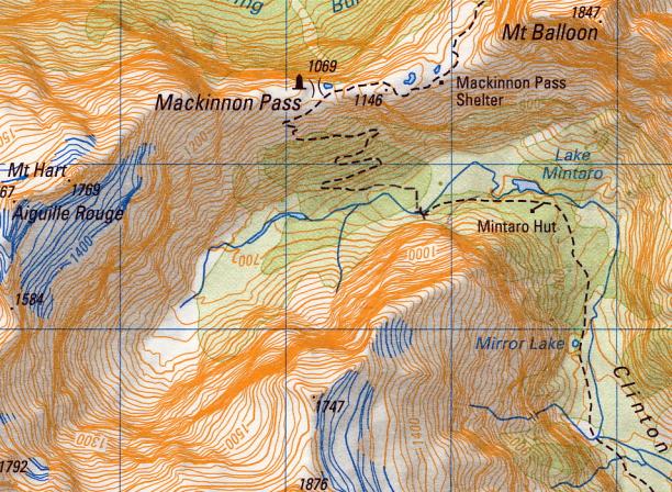
LOCATION: Upper Clinton valley, Milford Track (Clinton Hut to Mackinnon Pass Section)
B. GEOLOGICAL INSPECTION AND HAZARD ASSESSMENT
B1. GEOLOGICAL INSPECTION BY: G Hancox, N Perrin, 2 April; 29-30 Oct 2009
REPORT 22 July 2010
B2. PREVIOUS INSPECTIONS: G Hancox, 11 April 2000; R Thomson, 7 December 2007.
DATE:
B3. REFERENCES
Hancox, G., 2000: Baseline Inspection Report on Mintaro Hut.
GNS Hut Site Report.
3
Thomson, R., 2008: Seismic Impact on the Milford Track: Report on rockfall inspections 7 Dec 2007
8.
(see Section C11 for full list of references used in the report)
2095
E
96
97
98
C. REPORT
C.1. SITE DESCRIPTION
87
C1.1 LOCATION:
M i n t a r o
R i d g e
Mintaro Hut is located at an altitude of c.620 m on the south
86
(true right) side of the upper Clinton valley, on the Milford
Track between Clinton Hut and Mackinnon Pass. The hut
site is on a bush-covered knoll about 15 m above the level of
the track, well above the Clinton River and Lake Mintaro
(
see Location Map).
5585
N
SITE LOCATION MAP (1:50,000 – D41)
C1.2 TOPOGRAPHY:
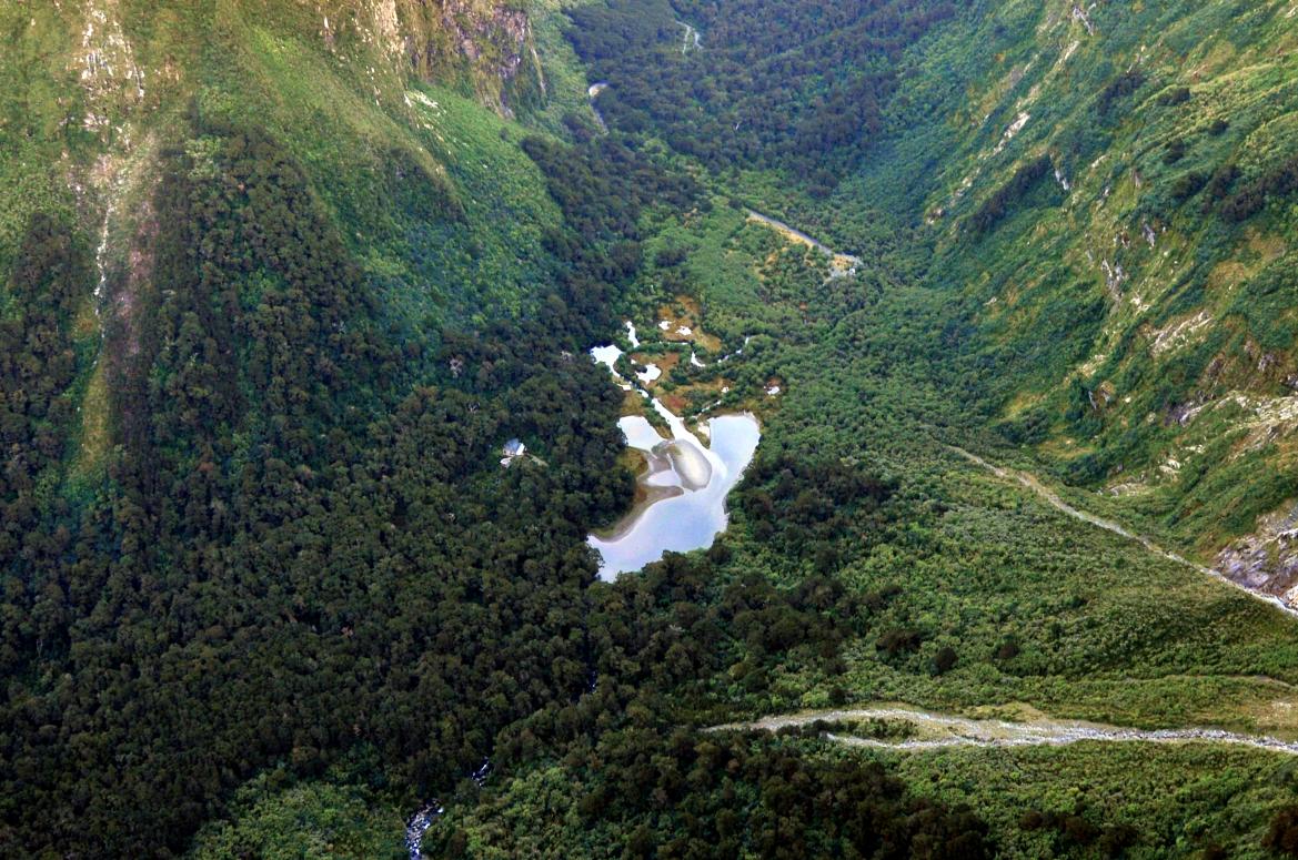
The hut is sited on a mound of old rock fall debris overlooking Lake Mintaro, a small (c.200 m long) landslide and
fan-dammed lake in the head of the Clinton valley. The site is bush-covered and is relatively flat, with abundant
boulders apparent on the ground surface. About 50 m southwest of the hut the valley slope
(„Mintaro Ridge‟ 8) rises
steeply (45-65 ) to an elevation of c.1250 m up the glaciated rock wall of the Clinton valley. The slope below the
hut falls gently c.20 m to the broad valley bottom and the partly infilled Lake Mintaro
(see site photos).
C1.3 SITE EXPOSURE:
The site is in dense bush in the valley floor and is relatively sheltered.
C1.4 VEGETATION:
Mature Fiordland rain forest (silver beech) and sub-alpine scrub.
C1.5 FLOODING HAZARD:
Very low - hut is about 20 m above the Clinton River and Lake Mintaro.
C1.6 OTHER COMMENTS:
Several snow avalanche paths are present in the area
(see Site Map 2) 6.
Rock fall activity in the vicinity of Mintaro Hut (in gully c 400 m southwest of hut) was reported by DoC staff to have
occurred during the 16 October 2007, ML 6.7 earthquake. GNS Science (GeoNet) reported that the earthquake
was located 60 km west of Milford Sound (approx. 50 km WNW of Mintaro Hut). The Modified Mercalli (MM)
shaking intensity in the Milford Sound–Mintaro Hut area was estimated to be MM 6–7
(see Appendix 3).
The maximum MM intensity reported was MM 7 in the Hollyford valley. Rock fall effects caused by the earthquake
in the vicinity of Mintaro Hut were inspected by Royden Thomson for DoC on 7 December 2007
8.
Note:
This report should be used with reference to the “Revised Geological Hazard and Risk Assessment Method for DoC
Backcountry Hut Sites and Camp Sites”. GNS Science Consultancy Report 2008/256 5.
.

GNS Science Consultancy Report 2009/118
Geological Inspection for: Mintaro Hut
Page 2 of 16
C2. SITE DESCRIPTION
S W
N E
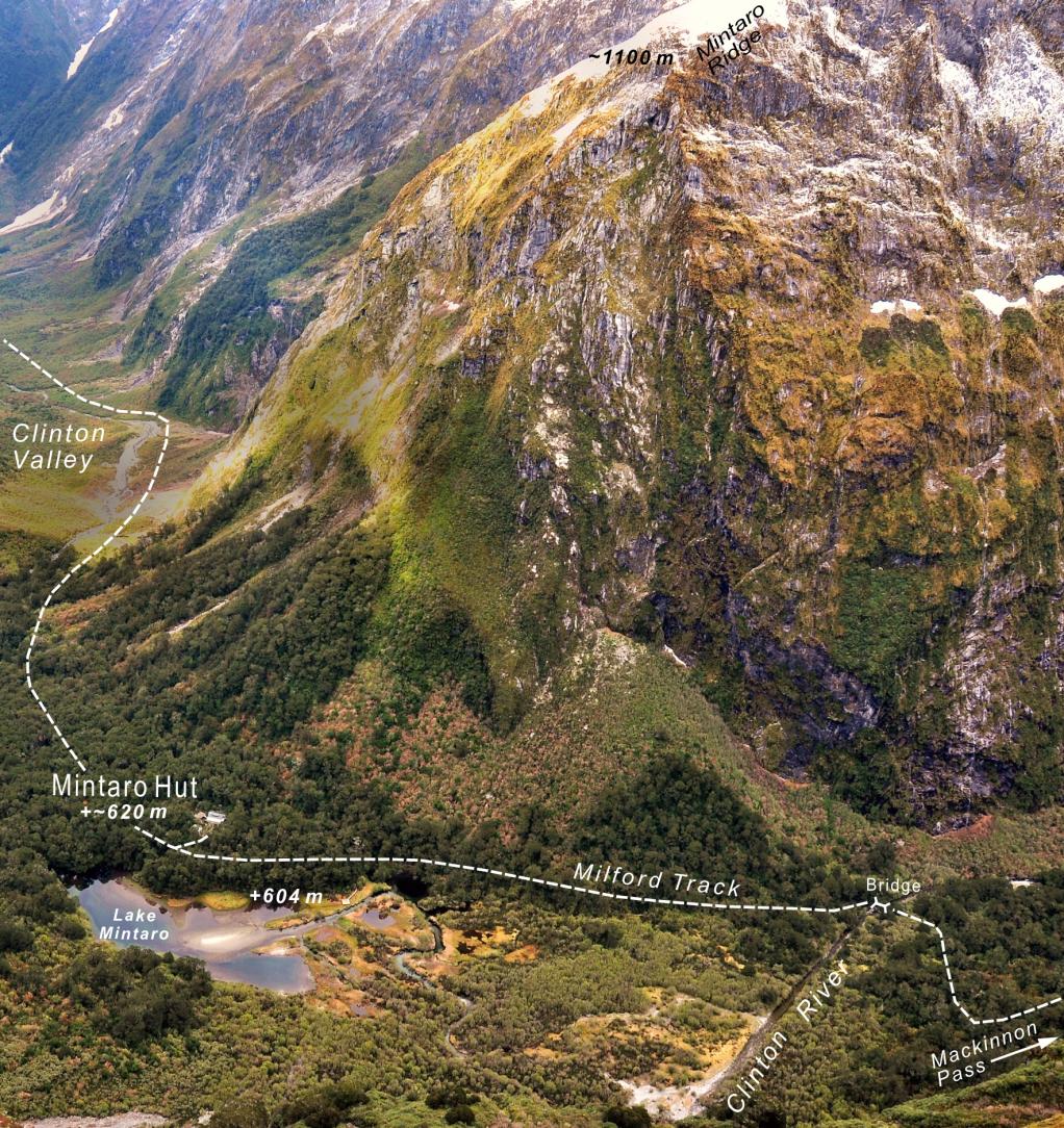
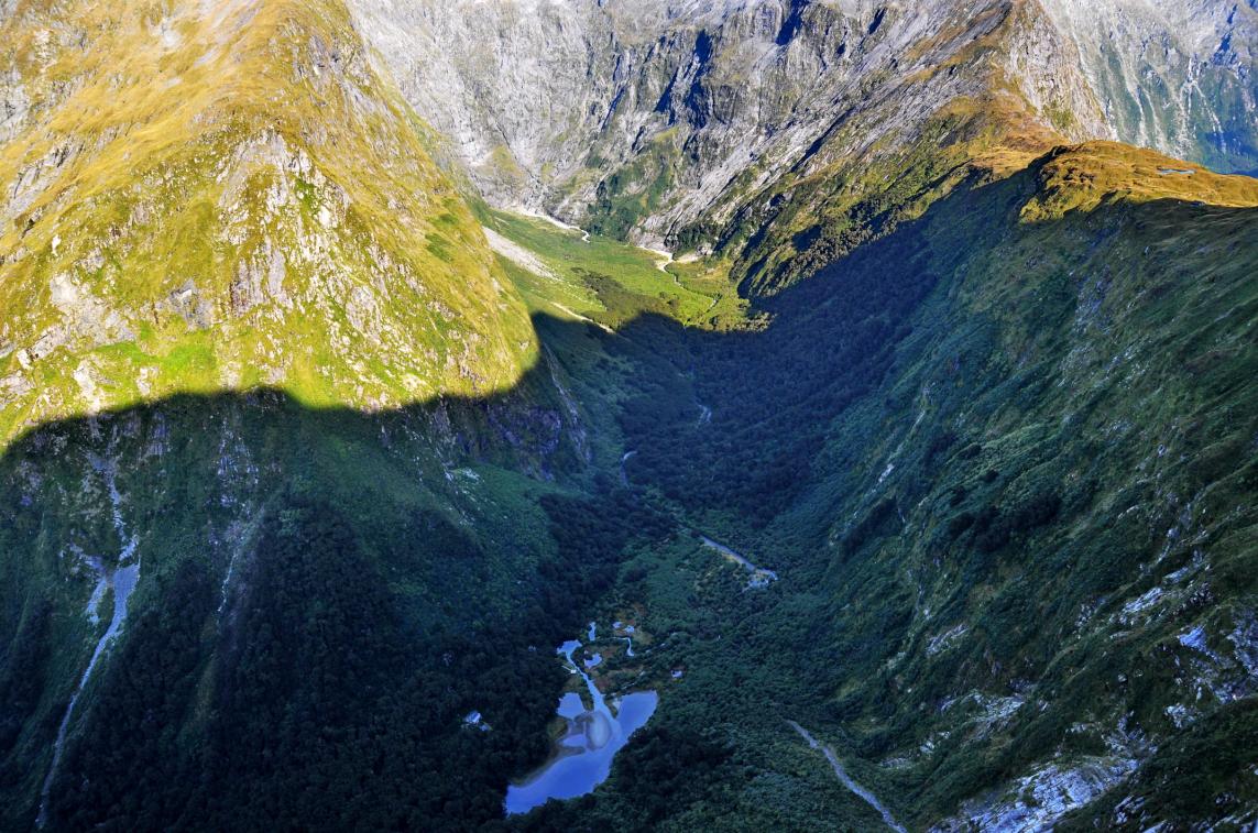
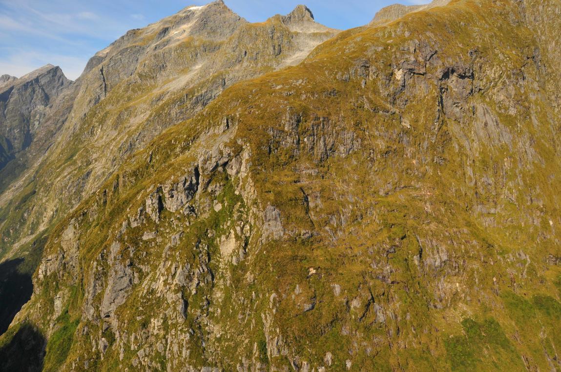
Site Photo. Aerial view of Mintaro Hut in the upper Clinton Valley. The hut is sited at the foot of Mintaro Ridge on
a mound of old rock fall debris which has dammed the Clinton River to form Lake Mintaro, which is now partly infilled.
The line of the site Cross Section
(NE-SW, below) is also shown.
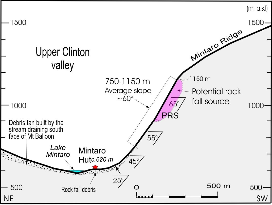
Site Cross Section. Topographic
cross section of the hut site showing
Mintaro Hut in relation to the slope
above and across-valley from the
hut site. The slope behind the hut
rises steeply from elevation 750–
1150 m, with an average slope of
about 60 . A potential rock fall
source (PRS) is located at the top of
the steepest section of the slope
directly above the hut.
GNS Science Consultancy Report 2009/118
Geological Inspection for: Mintaro Hut
Page 3 of 16
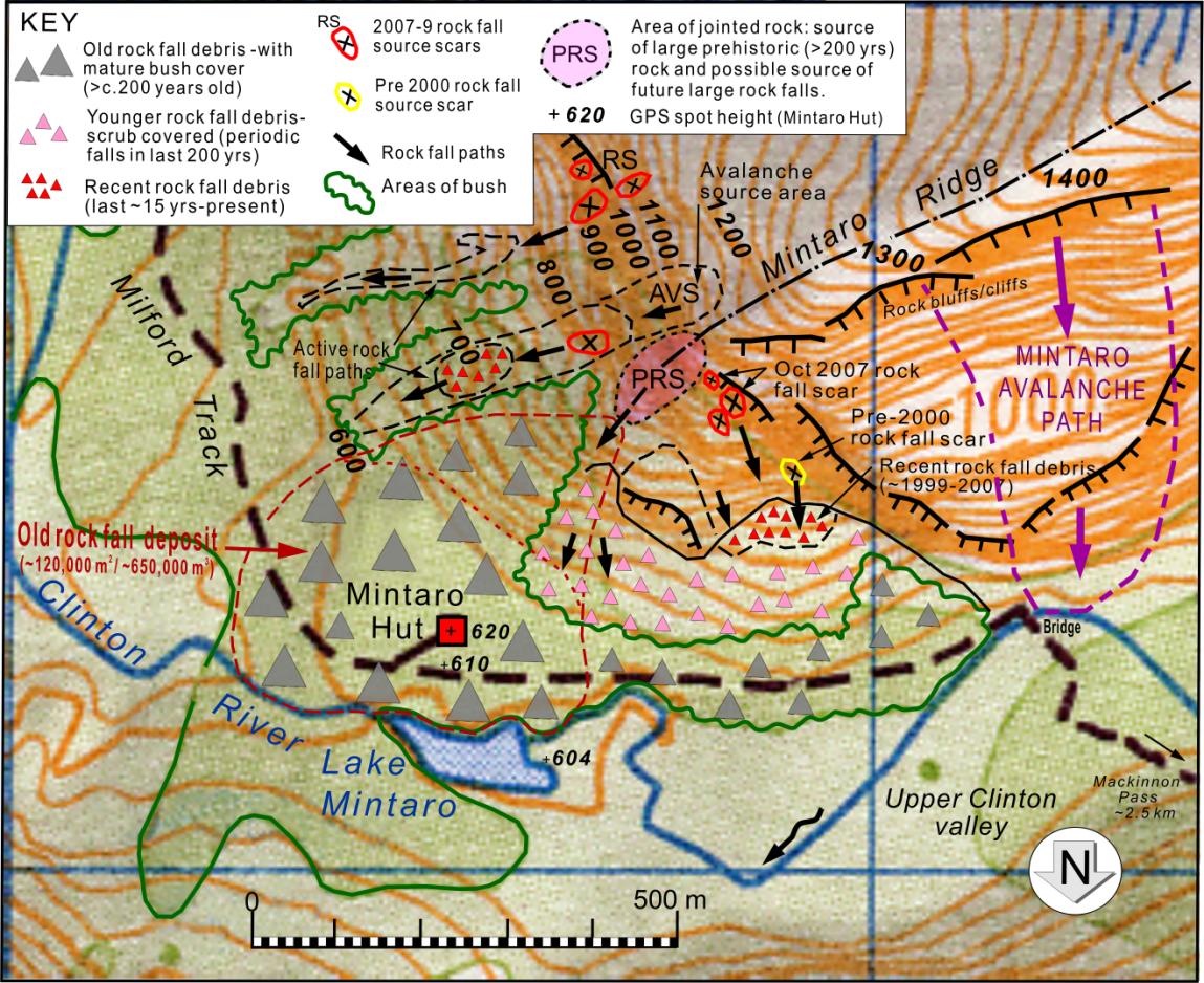
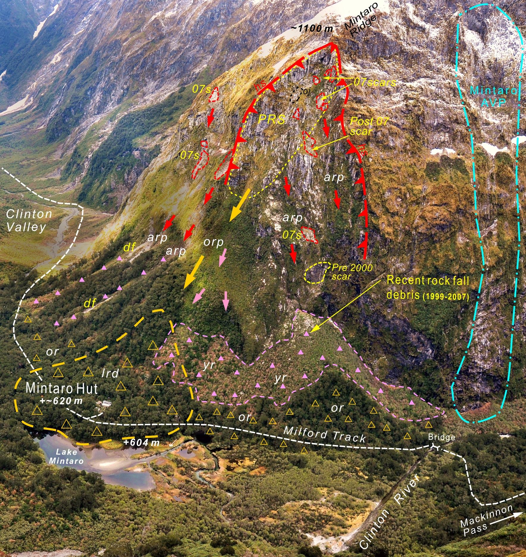
SITE MAP 1. Geomorphic map of hut site area
S W
Cross Section
Line (NE-SW)
N E
W
Site Map 1. Geomorphic map of Mintaro Hut site showing old and recent rock fall deposits, rock fall paths, October
2007 rock fall sources, and the possible source of a future large rock fall at the hut site. The volume of the older
rock fall deposits on which the hut is located (inside the dashed red line) is about ~650,000 m3.
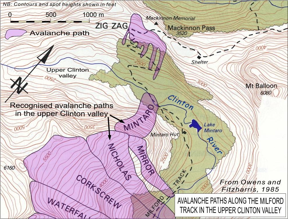
SITE MAP 2. Snow Avalanche Paths in the Mintaro Hut area
Site Map 2. Map showing snow
avalanche paths along the Milford Track
in the upper Clinton valley
6. Avalanches
may carry rock, soil and vegetation, and
build debris fans
(track location shown
is incorrect –see Site Map 1).
GNS Science Consultancy Report 2009/118
Geological Inspection for: Mintaro Hut
Page 4 of 16
C3. SITE PHOTOS
Photo 1. Aerial view of Mintaro Hut sited on old rock fall debris (yellow triangles) on the south side of the upper
Clinton valley. The old rock fall deposits at the hut site include angular boulders 1– 6 m across, on which ~170 year old
beech trees are growing. About 100 m southwest (upstream) of the hut is an area of younger, scrub-covered rock fall
debris, built up at the base of the slope by periodic rock falls down paths
(YRP) on the northwest side of Mintaro Ridge.
These falls did not reach the hut site. The October 2007 earthquake triggered several small rock falls near the crest the
ridge (scars outlined in red). Debris from these and other recent rock falls has accumulated at the apex of the debris fan,
c.400 m southwest of the hut. Rock at the top of the ridge directly above the hut is well jointed, with areas of relaxed
open-jointed rock
(OJ),and is a potential source of a future large rock fall at the site
(PRS), particularly during a large
(M7.5 or >) earthquake. The Mintaro avalanche path
6 c.650 upstream (right) of the hut, does not affect the site.
GNS Science Consultancy Report 2009/118
Geological Inspection for: Mintaro Hut
Page 5 of 16
C3. SITE PHOTOS (contd.)
M i n t a r o
R i d g e
M a c k i n n o n
P a s s
P R S
U p p e r C l i n t o n
v a l l e y
M i n t a r o
H u t
Photo 2. Aerial view of Mintaro Hut site in the head of the Clinton valley, and Mackinnon Pass 1.5 km to the
northwest. An area of steep, jointed rock on the northern end of Mintaro Ridge is a potential source of a large rock
falls
(PRS) that could affect Mintaro Hut in the foreseeable future (next 50 years). The hut is founded on bush
covered old rock fall debris, which last fell from that
(PRS) part of the ridge possibly c. 200 years ago.
r d
y d
r p
H
L a k e
o d
M i n t a r o
D e b r i s
f a n
C l i n t o n
R i v e r
Photo 3. Closer view of Mintaro Hut
(H). The old, bush covered rock fall debris
(od) includes 1-6 m boulders, which
are scattered around the site. Other features to note are younger, scrub-covered, rock fall deposits
(yd); recent
(c.1990-2007)
rock fall debris
(rd), and an active rock fall path
(rp) about 250 m downstream. The partly-infilled
Lake Mintaro was formed by blockage of the Clinton River by rock fall debris and a large debris fan
(lower right).
GNS Science Consultancy Report 2009/118
Geological Inspection for: Mintaro Hut
Page 6 of 16
C3. SITE PHOTOS (contd.)
R S
M i n t a r o
R i d g e
M R
R S
o s
R S
o s
o s
R o c k f a l l s o u r c e a r e a
( l a s t c . 2 0 0 - 4 0 0 y e a r s )
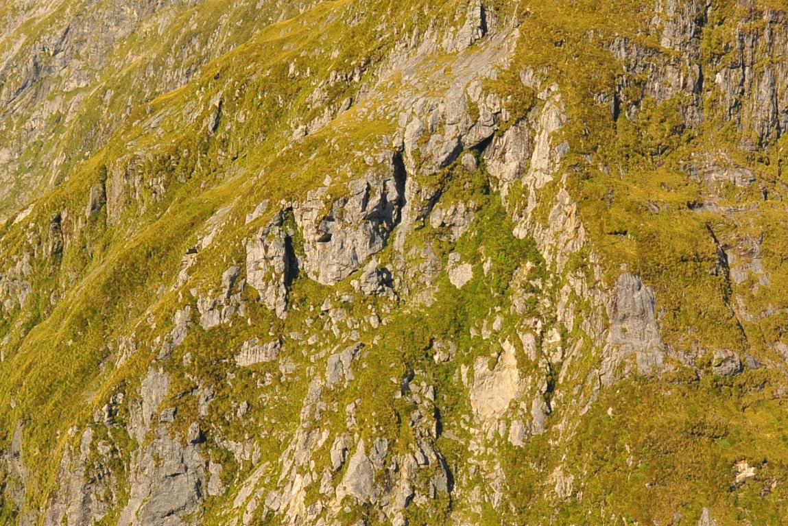
Photo 4. Aerial view of an area of well jointed rock on the ridge 400-500 m above Mintaro Hut, which was the
source of rock fall debris on which the hut is built, and is the likely source of future large rock falls at the site.
Scars of older wedge failures are still visible
(os), as are the source-scars of the October 2007 rock falls
(RS).
The glaciated rock mass to the right is more massive and has few failure scars.
o s
o s
R S
O J
R S
r p
o s
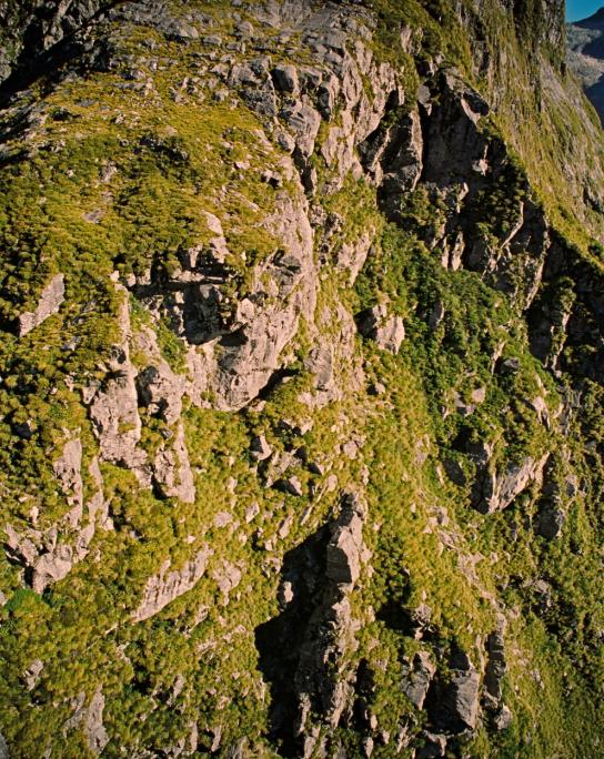
Photo 5. Closer view of the jointed rock on the ridge above Mintaro Hut showing scars of older failures
(os), one
large area of opened jointed rock
(oj), and source-scares
(RS) and paths
(rp) of the October 2007 rock falls.
GNS Science Consultancy Report 2009/118
Geological Inspection for: Mintaro Hut
Page 7 of 16
C3. SITE PHOTOS (contd.)
M i n t a r o
R i d g e
1
O J
2
Photo 6. Aerial view of two prominent areas of open-jointed
rock
(OJ) on the ridge about 500 m above Mintaro Hut. This
photo was taken in April 2000. Both of these sites survived the
October 2007 earthquake, although one small (~I m) block was
O J
dislodged from the upper site. The vertical extent of the lower
site is estimated to be at least 15-20 m. The approximate
locations of two of the 2007 rock fall source-scars are also
shown
(sites 1 and 2).
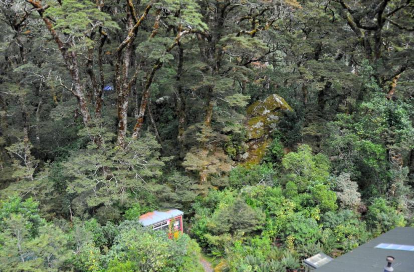
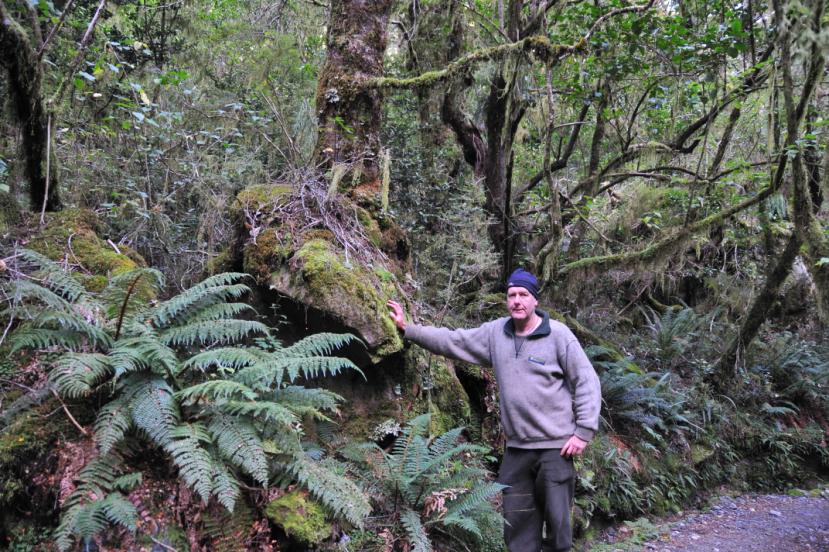
Photo 7. Close up view of the area
behind Mintaro Hut
(H) showing a large
(6 x 4 x 3 m) boulder
(b) 17 m from the
b
hut. There are also many other 1–2 m
boulders scattered around the hut site.
t
A silver beech tree about 500 mm in
diameter is growing on the boulder.
Coring of a nearby beech tree 560 mm
in diameter showed the tree to be c.165
years old. Assuming there was a forest
regrowth time lag of c.20 years, the last
large fall rock fall to reach the hut site
H
occurred possibly 180-200 years ago.
Photo 8. Silver beech tree growing on
a rock fall boulder on the Milford Track,
25 m north of Mintaro Hut. This tree is
slightly smaller and younger
(~83 years
old, see Appendix 4) than the tree which
was cored
(see Photo 9).
GNS Science Consultancy Report 2009/118
Geological Inspection for: Mintaro Hut
Page 8 of 16
C3. SITE PHOTOS (contd.)
t 2
t 1
b
t c
Photo 9. This photo shows the 560 mm diameter
silver beech tree
(t1) behind Mintaro Hut. Coring of
this tree with an incremental tree corer (
tc) showed
that it is about 165 years old. The large rock fall
boulder
(b) to the left of the cored tree has a beech
tree
(t2) of similar size and age growing on it. This
indicates that the last rock fall to reach the hut site
could have occurred about 180-200 years ago.
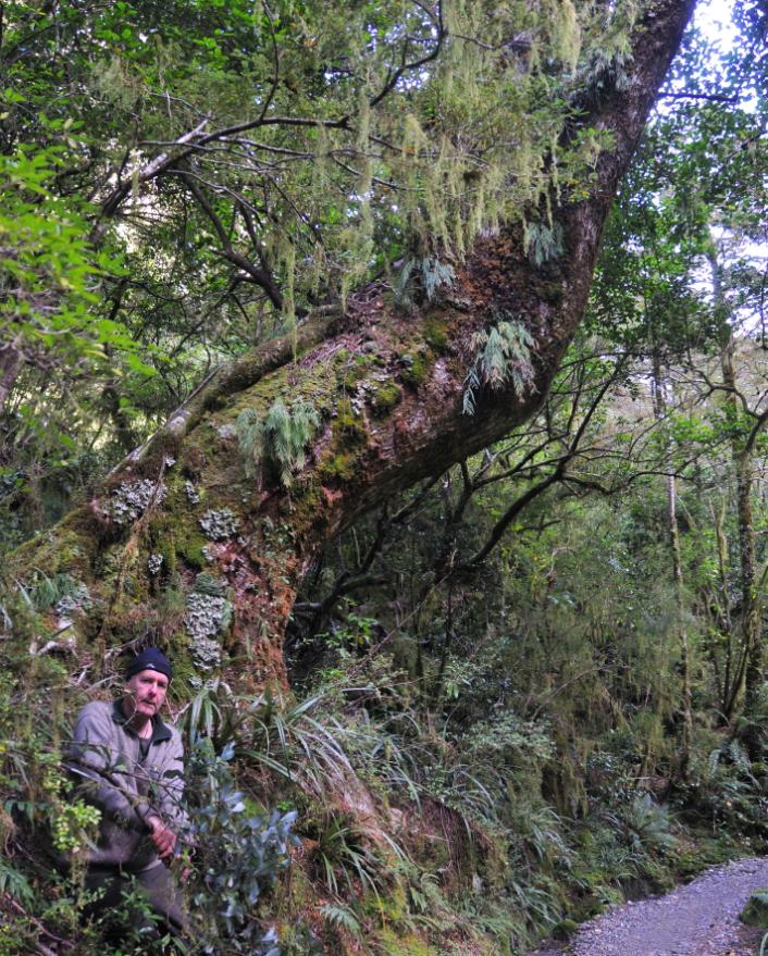
Photo 10. The tree shown here is one of a number
of larger (c.1 m diameter), c.325 year old beech
trees growing on older rock fall debris around the
hut site. This particular tree, which is on the Milford
Track about 20 from the hut, was knocked over and
tilted by a 1.5 m boulder (out of picture to the left),
after which it continued to grow sub-vertically. This
suggests there has been a succession of large rock
falls on to the Mintaro Hut site in the last few
hundred years. The last large rock fall in the hut site
area occurred possibly about 183 years ago, during
the 1826 Fiordland earthquake (~M 8-8.5)
1.

GNS Science Consultancy Report 2009/118
Geological Inspection for: Mintaro Hut
Page 9 of 16
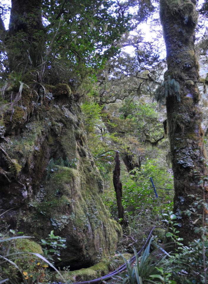
C4. SITE GEOLOGY
Mintaro Hut is sited on a knoll of old rock fall debris derived from a very steep (45-65 ) ridge (Mintaro
Ridge) on the south wall of the Clinton valley, immediately behind (southwest) of the hut (s
ee Site Maps
and Photos). Based on the GNS 1:250,000 Geological Map 18
9, bedrock in the Mintaro Hut site area
is
granitic orthogneiss. The rock is unweathered and very strong, but is weakly foliated, and has
well developed joint sets. On the Mintaro Ridge above 900 m (elevation) the joints are steep to
sub-vertical, closely spaced (about 0.5-1 m), and persistent over c.5-10 m or more. Some of the
joints are open and show signs of rock mass dilation
(see Photo 6).
The coarse rock fall debris on which the hut is built is estimated to be at least ~20 m thick, and includes
angular gravel with boulders from 1 to 6 m across
(Photos 7 and 9). The rock fall debris covers an
area of c.120,000 m2, and has an estimated volume of about 650,000 m3. Rock fall debris and a
large debris fan formed by the stream draining the south face of Mt Balloon has blocked the Clinton
River to form
Lake Mintaro, which is now partly infilled with glacial and alluvial sediments
(Photo 3).
The rock fall deposit which the hut is sited on is inferred to have accumulated in the Clinton valley bottom
over the last 10,000-12,000 years, since the end of the last glaciation. Silver beech forest on the older
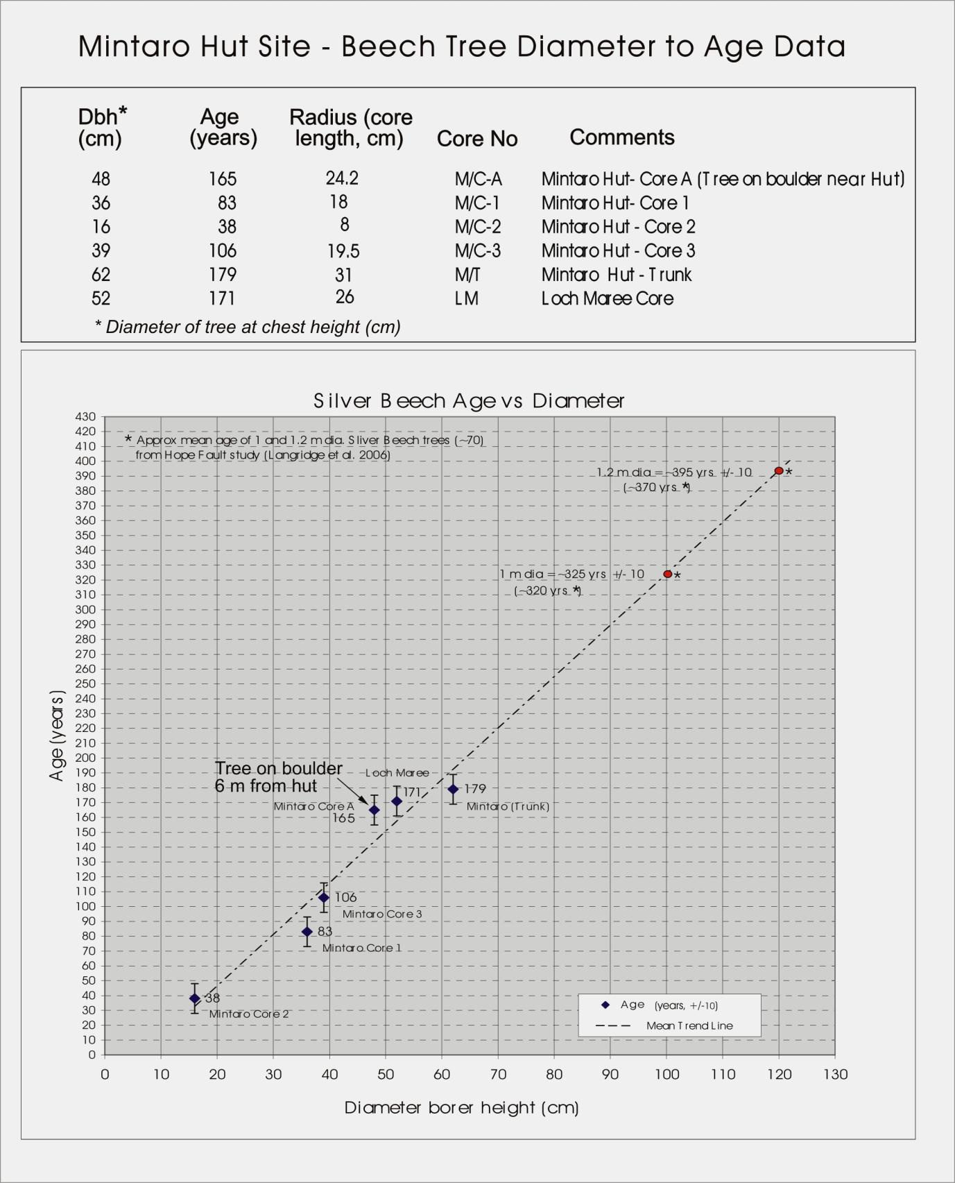
rock fall deposits includes trees up to ~600 mm diameter growing on boulders near the hut. Incremental tree
coring has shown that these beech trees are approximately 165-180 years old
(see Appendix 4).
This suggests that the last large fall rock fall at the site occurred at least 180-200 years ago, possibly during
the ~M 8 Fiordland earthquake of 1826
1. There are also some ~1– 1.2 m diameter
* (~300-400 year old)
beech trees growing on older rock fall debris near the hut
(Photo 10), which may have been deposited
during the last (1717) Alpine Fault earthquake about.300 years ago
10, 11.
Scrub-covered rock fall debris c. 80 m southwest of the hut
(Site Map 1) suggests there have been periodic
smaller rock falls in the area which prevented establishment of beech forest, but did not reach the hut site.
No rock fall trails are apparent in beech forest near the site.
* Tree diameter at breast height (standard measurement point).
C5. SITE and FOUNDATION STABILITY
The foundation material at Mintaro Hut is old, bush covered rock fall debris – angular gravel and large
angular boulders of orthogneiss, which provides a stable, well drained foundation for the hut.
No foundation stability or erosion problems are present at the site.
GNS Science Consultancy Report 2009/118
Geological Inspection for: Mintaro Hut
Page 10 of 16
C6. GEOLOGICAL HAZARDS – Summary
(for details refer to Section C8, C9, and Appendices 1, 2, and 3.
Mintaro Hut is potentially exposed to a range of geological hazards, and it has been assigned an overall
geological hazard rating of
Moderate (14), based on the all types of geological hazards, which are listed
and rated in
Appendix 1. The foundation material (coarse angular gravel and boulders) provides a stable
foundation for the hut, and because of its elevated position 20 m above the valley floor it is not exposed to
erosion, flooding or debris flow hazards, for which low ratings (0 -1) are assigned. However, the hut is
sited on an old rock fall deposit, below a very steep, high slope, and is directly in the rock fall hazard zone
if future large rock falls occur, especially during strong earthquake, for which the maximum possible
hazard ratings (5) are assigned. The all-hazard rating
(Moderate) of
the site is potentially misleading as it
tends to downplay the significant hazard and risk presented by future earthquake-triggered rock falls at
the site. Therefore, for the evaluation of geological hazards and risk at Mintaro Hut greater reliance is
placed on the qualitative rock fall risk assessment presented in Section C8 and Appendix 2.
The 16 October 2007, ML 6.7 earthquake (locally MM 6-7) caused small rock falls (c.1-2 m3, in total possibly
5 –10 m3) in gullies 200-400 m from the hut
(see Site Map 1 and Photo 1).
). No rock falls appear to have
reached the hut site in the last ~180–200 years, based on tree-ring dating. However, jointed rock on the
ridge above the hut is a potential source of future large rock falls (possibly c.1000 –10,000 m3 or >) that
could affect the hut, given a suitable trigger, such as a nearby ~M 7.5 or > earthquake. The estimated
volume (c. 650,000 m3) of old rock fall debris suggests there have been many such earthquake-induced
rock falls at this site in the last 10,000 years, and they will continue to occur in the future. Rainfall induced
landslides, typically shallow slides and flows, have not affected the site in the past and, mainly because of
the geomorphic features at the site, are unlikely to in the future.
Qualitative ratings of the
risk from geological hazards at Mintaro Hut (
Section C8 and Appendix 2) are
assessed to range from
Very Low to
High to Very High. The hut site should be inspected by an
engineering geologist when future small rock fall occur
(Priority 4).
The major hazard at the site is from a future large rock fall (c.1000 m3 or greater, with 1–6 m boulders)
triggered by an Alpine Fault earthquake (the probability of this event in the next 50 years is potentially as
high as ~30%)
7, 11, or a large subduction zone earthquake, as occurred in 1826. Because a large rock
fall at the site is likely to cause substantial damage to the hut and probably loss of life, the
risk from such
an event is considered to be
High to Very High.
Because of the very steep, inaccessible terrain at the site, slope stabilisation or rock fall protection
measures to reduce the potential risk from earthquake triggered rock falls at Mintaro Hut are likely to be
impractical. It is therefore recommended that DoC give consideration to moving the hut to a lower risk
location as soon as reasonably practicable
[Priority 2].
C7. SITE MONITORING
No instrumental or survey monitoring is necessary at Mintaro Hut. However, the site is prone to periodic
rock fall activity, and DoC should keep a record of future rock falls that occur at or near the hut site. Any
new rock fall activity should be evaluated by an engineering geologist. The condition of the jointed rock
mass on the ridge directly above the hut should also be inspected (by helicopter).
[Priority 4: moderate
significance - should be attended to when such events occur.]
GNS Science Consultancy Report 2009/118
Geological Inspection for: Mintaro Hut
Page 11 of 16
C8. QUALITATIVE RISK ASSESSMENT SUMMARY
(Refer to Appendix 2 for risk criteria and definitions)
Hazard Type
Likelihood 1
Consequence Risk Level
Comments and Risk Management Options
s
The risk from small rock fal s (like those during the October 2007
1. Small rock falls
Almost certain
Insignificant
Very Low earthquake) is acceptable because such fal s do not reach the hut.
(~1-10 m3)2 - as have
RP: 1–10 yrs
to Low
Smaller rock fal s tend to be channeled down gul ies away (upstream or
occurred at the site in
AEP: 95–10 %
downstream) from the hut. However, the site and rock fal source areas
the last few years.
should be inspected by an engineering geologist after such events in
the future. The risk is
acceptable with this management measure.
Areas of ‘younger‘ scrub-covered, rock fal debris near the hut suggest
2. Small to moderate
Likely
Insignificant
Low
that small to moderate rock fal s have occurred near the hut site
rock falls
RP: 10–100 yrs
periodically over the last few hundred years (probably during strong
(~10 – 102 m3,
AEP: 10–1.0 %
earthquakes), preventing growth of beech forest. Debris from such
with 1–2 m boulders)
fal s has travelled mainly down gul ies away from the hut, and has not
come to within c.80-100 m of the site. In addition, beech trees around
the hut provide effective protection from smaller boulders (c.0.5–1 m),
preventing them from reaching the hut. For these reasons the level of
risk for
small to moderate rock fal s is thought to be
acceptable.
Geological and geomorphic evidence shows there is potential in the
3. Large earthquake-
Possible
Major to
High to
future for a large rock fal at the hut site (c.1000 m3 or >, with 1-6 m
induced rock falls
RP: 100–1000 yrs
Catastrophic
Very High boulders) especially during a large earthquake (≥ M 7.5–8.0; MM9-10)
(~103 m3 or >,
AEP: 1.0–0.1 %
on the Alpine Fault or the Fiordland Subduction Zone. Earthquake-
with 1–6 m boulders)
induced landslides typically affect high, steep slopes and ridges, where
shaking effects are amplified
2, 4. There is a relatively high probability
(up to ~30%) of an Alpine Fault earthquake in the next 50 years
7, 11.
The
consequences of large rock fal would be
major to
catastrophic
(damage and loss of life expected), and the
risk of such an event is
assessed as
High to
Very High. Treatment options to reduce risk at
the site to an acceptable level are probably impractical, and this
probably means that the hut should be moved to a new site.
4. Rainfall-induced
Almost certain
Insignificant
Very Low Although rainfal -induced landslides (typically shal ow slides and flows)
Landslides
RP: 1–10 yrs
to Low
occur frequently, there is no evidence of such failures in the immediate
AEP: 95–10 %
hut site area. The risk from such events is therefore
acceptable.
5. Foundation
Rare
Minor
Very Low The materials on which the hut are built are not prone to collapse or
failure
(0.02–0.01 %)
erosion given the existing site conditions. Risk
acceptable.
6. Flooding,
Inconceivable
Insignificant
Very Low The elevated hut site is well above river level and there are no tributary
debris flows
(< 0.01 %)
streams close to the hut. Risk
acceptable.
7. Snow avalanches
Unlikely
Insignificant
Very Low The closest known avalanche path
(Mintaro - RP 20yrs) 6 does not
(associated rock and
RP: ~1000-5000 yrs
affect the hut site. There is
no known snow avalanche activity at the
debris flows)
AEP:~0.10–0.02 %
site. Risk
acceptable.
Notes and additional comments:
1. Likelihood (%) estimates are given as the approximate Return Periods (RP) and the annual probability, or and Annual
Exceedance Probability (AEP)- Appendix 2 5.
2. The terms used to describe the relative size landslides and rock falls apply only in the context of this report. In most
instances the terms used are qualified by an approximate landslide volume (m3). The volumetric estimates can be used
to compare the size of rock falls listed above with terms used for the much greater range of landslide sizes in Appendix 3.
3. References 2, 4, 5, 6 (etc) are listed in Section C11.
GNS Science Consultancy Report 2009/118
Geological Inspection for: Mintaro Hut
Page 12 of 16
C10.
CONCLUSIONS and RECOMMENDATIONS
1.
Mintaro Hut is sited on a knoll of old rock fall debris on the south side of the upper Clinton valley.
Foundation material at the site is compact angular gravel and boulders, which is thought to be stable
and resistant to erosion and collapse.
2.
The hut site is potentially exposed to a range of geological hazards, and has a been assigned an overall
Geological Hazard Rating of Moderate, mainly because of the hut’s location within a rock fall hazard
zone, and the possible effects of a future large earthquake in the area.
3.
The existing evidence suggests that rock falls from the ridge above Mintaro Hut large enough to reach
the hut site (possibly 1000 m3 with boulders up to 6 m across) may occur every 100-200 years. The last
rock falls to reach the site were probably triggered by earthquake shaking of MM8–9 or >
(Appendix 3),
which probably last occurred during the 1826 Fiordland Subduction Zone earthquake, and before that
the 1717 Alpine Fault earthquake. Shaking of similar intensity (~MM8–9) in the future is expected to
trigger further large rock falls at the site. The consequences of such an event could be catastrophic.
4.
Qualitative ratings of risk posed by geological hazard at Mintaro Hut range from
Low to Very Low
for small and moderate sized rock falls, to
High to Very High for a future large rock fall triggered
by an Alpine Fault earthquake, or possibly a large subduction zone earthquake similar to the 1826
earthquake. Such a rock fall is likely to cause substantial damage to the hut and probably loss of life.
5.
Because mitigation measures to reduce the risk from rock falls at Mintaro Hut to an acceptable
level appear to be impractical, it is recommended that consideration should be given to moving the
hut to a lower risk location as soon as reasonably practicable
[Priority 2].
C11.
REFERENCES
1. Downes, G. Cochran, U., Wallace, L, Reyners, M., Berryman, K., Walters, R., Callaghan, F., Barnes, P.,
Bell, R., 2005. Understanding local source tsunami: 1820 Southland tsunami. EQC Project 03/490.
GNS
Science Client Report 2005/153.
2. Hancox G.T., Perrin N.D., Dellow G.D., 1997. Earthquake-induced landsliding in New Zealand and
implications for MM intensity and seismic hazard assessment.
GNS Client Report 43601B. 106 p.
3. Hancox, G.T., 2000. Baseline Inspection Report on Mintaro Hut. GNS Hut Site Report.
GNS Science
Baseline Geological Inspections of DoC Hut Sites, 11 April 2000.
4. Hancox G.T., Perrin N.D., Dellow G.D., 2002. Recent studies of historical earthquake-induced landsliding,
ground damage, and MM intensity in New Zealand.
Bulletin of the New Zealand Society for Earthquake
Engineering 35(2): 59–95.
5. Hancox, G.T., 2008. Revised Geological Hazard and Risk Assessment Method for DoC Backcountry Hut
Sites and Camp Sites.
GNS Science Consultancy Report 2008/256, 16 October 2008.
6. Owens, I.F., Fitzharris, R.R., 1985. Avalanche Atlas of the Milford Track and Assessment of the
Hazard to Walkers.
NZ Mountain Safety Council, Avalanche Report No 8, November 1985 .
7. Rhoades, D.A., Van Dissen, R.J., 2003. Estimates of the time-varying hazard of rupture of the Alpine
Fault, New Zealand, allowing for uncertainties.
New Zealand Journal of Geology and Geophysics
46, 479–488.
8. Thomson, R., 2008. Seismic Impact on the Milford Track: Report on rock fall inspections 7 Dec 2007.
Consultancy report prepared for DoC Te Anau, January 2008.
9. Turnbull, I.M., (compiler) 2000. Geology of the Wakatipu area.
Institute of Geological and Nuclear Sciences
1:250,000 Map 18.
10. Wells, A., Yetton, M.D., Duncan, R.P., Stewart, G.H., 1999. Prehistoric dates of the most recent Alpine
Fault earthquakes, New Zealand.
Geology, November 1999, Vol. No. 11, pp. 995–998.
11. Biasi, G., Clark, K., Berryman, K., Cochran, U., Prior, C. 2010. Dating informed correlations and large
earthquake recurrence at the Hokuri Creek paleoseismic, Alpine Fault, New Zealand.
Proceedings AGU
Fall Meeting, 13–17, December 2010, San Francisco, Abstract T41C-08.
Acknowledgements
The authors wish to thank their GNS Science Colleagues Grant Dellow and Chris Massey for reviewing this
report, and also Ross Kerr (DoC Te Anau) for arranging access and accommodation at Mintaro Hut during
our field work for this study. We also wish to thank Royden Thomson for providing information from his
aerial inspection of the hut site following the 2007 earthquake.
GNS Science Consultancy Report 2009/118
Geological Inspection for: Mintaro Hut
Page 13 of 16
APPENDIX 1a: Geological Hazard Rating
Geological Hazard Rating is used to indicate the significance of a number of geological hazards (such as geologic
and topographic site conditions, slope failure, seismicity, flooding, seiches and volcanic activity) at DoC Hut and
Camp Sites. At specific sites, each hazard factor is subjectively assigned a factor value ranging from 0-5 (least to
most hazardous), based on the site inspection, monitoring, history, and other relevant data. An overall Geological
Hazard Rating (index) for the site is assigned by summing the factor values.
FACTOR VALUE
GEOLOGICAL HAZARD FACTORS
(Place X in appropriate cell to indicate Factor Values)
0
1
2
3
4
5
1. Slope angle and local topographic effects at site
X
2. Site geology and foundation materials
X
3. Proximity to steep slope below site
X
4. Hazard from slopes above site (rock and debris fall, avalanche, slide)
X
5. Foundation failure (none, possible, incipient, active)
X
6 Earthquake effects (topographic-enhanced shaking, slope failure)
X
7 Heavy rainfall, flooding, erosion, debris flows/floods etc.
X
8. Other (snow avalanches; faulting)
X
Sum of Hazard Factor Values:
14
GEOLOGICAL HAZARD RATING FOR: Mintaro Hut
14 (Moderate)
TOTAL FACTOR VALUES FOR GEOLOGICAL HAZARD RATINGS:
Very low: 0-5
Low: 6-12
Moderate: 13-18
High: 19-24
Very High: 25 or greater
APPENDIX 1b:
Priority Ratings For Recommendations:
The following Priority Ratings are used for rating Recommendations given in this report for mitigating geological
hazards at DoC hut sites and camp sites. They are mainly based on the Geological Hazard Rating and Risk Level at a
site, and indicate the time frame within which the recommendation should be attended to. Specific time frames for
responding to unacceptable risk from any hazard should be specified in the Qualitative Risk Assessment (C8).
Priority 1:
Recommendation of very great significance and URGENT, at a site where there is Very High geological
hazard (Rating >25) or Very High Risk from one or more hazard. Should be attended to immediately.
Priority 2:
Recommendation of great significance, at a site where there is High geological hazard rating or High Risk
from one or more hazard. Should be attended to, as far as reasonably practicable, within next 12-18 months.
Priority 3: Recommendation of considerable significance, at a site where there is Moderate geological hazard
(Rating 13-18), or Moderate Risk from one or more hazard. Should be attended to as far as reasonably
practicable, within the next three years.
Priority 4:
Recommendation of moderate significance, at a site where there is Low to Moderate geological hazard
(Rating 6-18) or Moderate to Low Risk from one or more hazards. Should be attended to, as far as
reasonably practicable, within the next five years.
Priority 5: Recommendation of some significance, at a site where there is low or very low geological hazard, or
Low Risk or Very Low Risk from a hazard. Should be attended to within the next ten years.
GNS Science Consultancy Report 2009/118
Baseline Geological Inspection for: Mintaro Hut
Page 14 of 16
APPENDIX 2: Qualitative Geological Hazard And Risk Assessment (see C8 and C9)
1- Qualitative Measures of Likelihood of Hazard Events
Indicative
Annual
Level
Descriptor
Description 1
Probability 2
Probability 2
(Return Period)
(%)
A
ALMOSTCERTAIN The event is ongoing, or expected to occur (in next 50 years)
1–10 years
c. 95 – 10
B
LIKELY
The event is expected to occur under adverse conditions.
10–100 years
10 – 1.0
C
POSSIBLE
The event could occur under adverse conditions.
100–1000 years
1.0 – 0.10
D
UNLIKELY
The event might occur under very adverse conditions.
1,000–5,000 years
0.10 – 0.02
E
RARE
The event could occur under extreme conditions.
5,000–10,000 years
0.02 – 0.01
F
INCONCEIVABLE
The event is inconceivable under present conditions.
>10,000 years
< 0.01
Notes1, 2: 1. Descriptions define in words the likelihood of a hazard event occurring and impacting on a structure, house, hut site or camp site.
2. Probabilities are approximate and may vary depending on hazard types, site history, and period of concern –in this case the next 50 years.
2 - Qualitative Measures of Consequences to Property and People from Hazard Events
Level
Descriptor
Description1
1
CATASTROPHIC
Structure completely destroyed or large scale damage requiring engineering works for
stabilisation. Fatalities and severe injuries are likely.
2
MAJOR
Extensive damage to most of structure, or extending beyond site boundaries requiring significant
stabilisation works. Severe injuries to people and some fatalities possible.
3
MEDIUM
Moderate damage to some of structure, or significant part of site requiring stabilisation works.
Injuries requiring medical treatment, hospitalisation; fatalities unlikely.
4
MINOR
Limited damage to part of structure or part of site requiring some reinstatement or stabilisation
works. Minor injuries, without hospitalisation.
5
INSIGNIFICANT
Little damage. No injuries.
Note: 1. Examples of possible consequences are given as a general guide, and can be adapted to suit particular cases or sites.
3 - Qualitative Risk Analysis Matrix – Level of Risk to Property and People from Hazard Events
LIKELIHOOD
CONSEQUENCES to PROPERTY and PEOPLE
1: CATASTROPHIC
2: MAJOR
3: MEDIUM
4: MINOR
5: INSIGNIFICANT
A – ALMOST CERTAIN
VH
VH
H
M
L
B – LIKELY
VH
VH
H
M
L
C – POSSIBLE
VH
H
M
L
VL
D – UNLIKELY
H
M
L
L
VL
E – RARE
M
L
L
VL
VL
F – INCONCEIVABLE
L
VL
VL
VL
VL
4 - Risk Level Implications for Hazard Events
Risk Level
Implications and Response (1)
VH
VERY HIGH RISK
Investigation, planning and implementation of treatment options essential to reduce risk to an acceptable
level. This may be too expensive or not practical, and may require moving to a new site.
H
HIGH RISK
Investigation, planning and implementation of treatment options required to reduce risk to an
acceptable level. May be too expensive or impractical, and require moving to a new site.
M
MODERATE RISK
Tolerable provided treatment plan is implemented to maintain or reduce risks. May be accepted, but
requires investigation and planning of hazard mitigation measures.
L
LOW RISK
Usual y
acceptable. Some minor treatment options may need to be defined to maintain or reduce risk.
VL
VERY LOW RISK
Acceptable. Manage by normal inspection and monitoring procedures.
Notes: (1) The implications for a particular situation should be determined by all parties to the risk assessment; those given above are as a general guide only.
(2) Use of dual descriptors for Likelihood, Consequence and Risk to reflect uncertainty of the estimate may be appropriate in some cases.
Criteria for Qualitative Risk Assessment of landslides and geological hazards at DoC Hut Sites and Camp Sites.
(after Australian Geomechanics Society, 2000: Landslide Risk Management and Guidelines, Appendix G. Australian Geomechanics, 35 (1) 49–92.)
GNS Science Consultancy Report 2009/118
G
Baseline Geological Inspection for: Mintaro Hut
Page 15 of 16
APPENDIX 3. Modified Mercalli (MM) Intensity Scale –
Landslides and Environmental Criteria (4)
MM 6 Trees and bushes shake, or are heard to rustle. Loose material dislodged on some slopes, e.g. existing
slides talus and scree slope.
A few very small (<103 m3) soil and regolith slides and rock falls from steep banks and cuts.
A few minor cases of liquefaction (sand boil) in highly susceptible alluvial and estuarine deposits.
MM 7 Water made turbid by stirred up mud.
Very small (<103 m3) disrupted soil slides and falls of sand and gravel banks, and small rock falls from
steep slopes and cuttings common.
Fine cracking on some slopes and ridge crests.
A few small to moderate landslides (103 –105 m3), soil/rock falls on steep slopes (>30°) on
coastal cliffs, gorges, road cuts/excavations etc.
Small discontinuous areas of minor shallow sliding and mobilisation of scree slopes in places.
Minor to widespread small failures in road cuts in more susceptible materials.
A few instances of non-damaging liquefaction (small water and sand ejections) in alluvium.
MM 8 Cracks appear on steep slopes and in wet ground.
Significant landsliding likely in susceptible areas.
Small to moderate (103-105 m3) slides widespread; many rock and disrupted soil falls on steeper
slopes (terrace edges, gorges, cliffs, cuts etc).
Significant areas of shallow regolith landsliding, and some reactivation of scree slopes.
A few large (105-106 m3) landslides from coastal cliffs, and possibly large to very large (>106 m3) rock slides
and avalanches from steep mountain slopes.
Larger landslides in narrow valleys may form small temporary landslide-dammed lakes.
Roads damaged and blocked by small to moderate failures of cuts and slumping of road-edge fills.
Evidence of soil liquefaction common, with sand boils and water ejections in alluvium, and localised lateral
spreading (fissuring, sand and water ejections) and settlements along banks of rivers, lakes, and canals etc.
MM 9 Landsliding widespread and damaging in susceptible terrain, particularly on slopes steeper than 20°.
Cracking on flat and sloping ground.
Extensive areas of shallow regolith failures and many rock falls and disrupted rock and soil slides on
moderate and steep slopes (20°-35° or greater), cliffs, escarpments, gorges, and man-made cuts.
Many small to large (103-106 m3) failures of regolith and bedrock, and some very large landslides
(106 m3 or greater) on steep susceptible slopes.
Very large failures on coastal cliffs and low-angle bedding planes in Tertiary rocks. Large rock/debris
avalanches on steep mountain slope in well-jointed greywacke and granitic rocks. Landslide-dammed
lakes formed by large landslides in narrow valleys.
Damage to road and rail infrastructure widespread with moderate to large failures of road cuts slumping
of road-edge fills. Small to large cut slope failures and rock falls in open mines and quarries.
Liquefaction effects widespread with numerous sand boils and water ejections on alluvial plains, and
extensive, potentially damaging lateral spreading (fissuring and sand ejections) along banks of rivers,
lakes, canals etc). Spreading and settlements of river stop banks likely.
MM 10 Landsliding very widespread in susceptible terrain (3).
Similar effects to MM9, but more intensive and severe, with very large rock masses displaced on steep
mountain slopes and coastal cliffs. Landslide-dammed lakes formed. Many moderate to large failures of
road and rail cuts and slumping of road-edge fills and embankments may cause great damage and closure
of roads and railway lines.
Liquefaction effects (as for MM9) widespread and severe. Lateral spreading and slumping may cause rents
over large areas, causing extensive damage, particularly along river banks, and affecting bridges, wharfs,
port facilities, and road and rail embankments on swampy, alluvial or estuarine areas.
NOTES:
(1) “Some or ‘a few’ indicates that threshold for an effect or response has just been reached at that intensity. Effects below MM 6 generally insignificant in NZ.
(2) Intensity is principally a measure of damage. Environmental damage (response criteria) occurs mainly on susceptible slopes and in certain materials, hence the
effects described above may not occur in all places, but can be used to reflect the average or predominant level of damage (or MM intensity) in a given area.
(3) Environmental criteria have not been proposed for MM11 and 12, as those levels of shaking have not been reported in New Zealand.
(4) This appendix is based on Hancox et al. 1997 2, 2002 4. The environmental criteria described above have now been formally incorporated in the New
Zealand MM Intensity Scale (
Dowrick, D.J., Hancox, G.T., Perrin, N.D., Dellow, G.D., 2008. The Modified Mercalli Intensity Scale – Revisions Arising
From New Zealand Experience.
Bulletin of the NZ Society for Earthquake Engineering, 41(3):193–205.)
GNS Science Consultancy Report 2009/118
G
G
Page 16 of 16
APPENDIX 4. Beech Tree Diameter versus Tree-ring Age Data at Mintaro Hut
Reference
Langridge, R., Duncan, R., Almond, P., Robinson, R. 2007. Indicators of recent paleoseismic activity
along the western Hope Fault.
GNS Science Consultancy Report 2006/151.

Document Outline
- Mintaro Report- Cover Page CR 2009-118.pdf