File ref: IRO-10768
3 December 2020
Tony Randle
[email address]
Kia Ora Tony
Fol ow up to IRO-10409 Spatial Plan
Thank you for your request made under the Local Government Official Information and Meetings
Act 1987 (the Act), received on 2 November 2020. The Wel ington City Council (the Council) as
granted your request for information at no cost. Each of your fol ow up questions has been
responded to individual y.
4) Each location in Wel ington City that is "in city centre zones" as defined by Policy 3 (a) of the
National Policy Statement on Urban Development 2020 as well as the building heights and
densities required by Policy 3.
4a) The WCC has not provided the building heights information for each location that is “in city
centre zones” as requested.
4b) The WCC has not provided the building density information for each location that is “in city
centre zones” as requested.
The Building heights of the City Centre zones:
• A maximum building height of at least ten storeys in Te Aro.
• Maximum building height of up to eight storeys (i.e. areas along the edge of the city in
Thorndon, Aro Valley, and Mt Victoria.
• No change to maximum building heights from those in the operative district plan
elsewhere within the Central City, including within heritage areas.
• All other areas in the city centre zone is a minimum building height of six storeys.
• These can be influenced by feedback on the Draft Spatial Plan.
Th
e Wel ington Outer Suburbs Assessment & Evaluation (pg 22) provides the heights in meters for
the Storeys.
For density ranges of the Draft Spatial Plan typology proposals see:
https://planningforgrowth.wel ington.govt.nz/__data/assets/pdf_file/0022/14953/PFG-Draft-
Spatial-Plan-Growth-Figures-25-September.pdf
5) Each location in Wel ington City that is "in metropolitan centre zones" as defined by Policy 3 (b)
of the National Policy Statement on Urban Development 2020 as wel as the building heights and
densities required by Policy 3.
5a) The WCC has not provided the building heights information for each location that is "in
metropolitan centre zones" as requested.
5b) The WCC has not provided the building density information for each location that is "in
metropolitan centre zones" as requested.
The Metropolitan Centre Zones is Johnsonville and Kilbirnie, the maximum height for these areas
is eight storeys. The
Wel ington Outer Suburbs Assessment & Evaluation (pg 22) provides the
heights in meters for the Stories.
For density ranges of the Draft Spatial Plan typology proposals see:
https://planningforgrowth.wel ington.govt.nz/__data/assets/pdf_file/0022/14953/PFG-Draft-
Spatial-Plan-Growth-Figures-25-September.pdf
6) Each location in Wel ington City that "within at least a walkable catchment of". ."existing and
planned rapid transit stops" as defined by Policy 3 (c)(i) of the National Policy Statement on Urban
Development 2020 as well as the building heights and densities required by Policy 3.
6a) The WCC has not provided the walkable catchment which is "within at least a walkable
catchment of". ."existing and planned rapid transit stops" for Johnsonvil e Station and for Raroa
Station as requested.
6b) The WCC has not provided the building heights information for each location that is "within at
least a walkable catchment of". ."existing and planned rapid transit stops" as requested.
6c) The WCC has not provided the building density information for each location that is "within at
least a walkable catchment of". ."existing and planned rapid transit stops" as requested.
6d) The WCC has not provided the evidence used to support the extent of the walkable catchment
for each location that is "within at least a walkable catchment of". ."existing and planned rapid
transit stops" as requested.
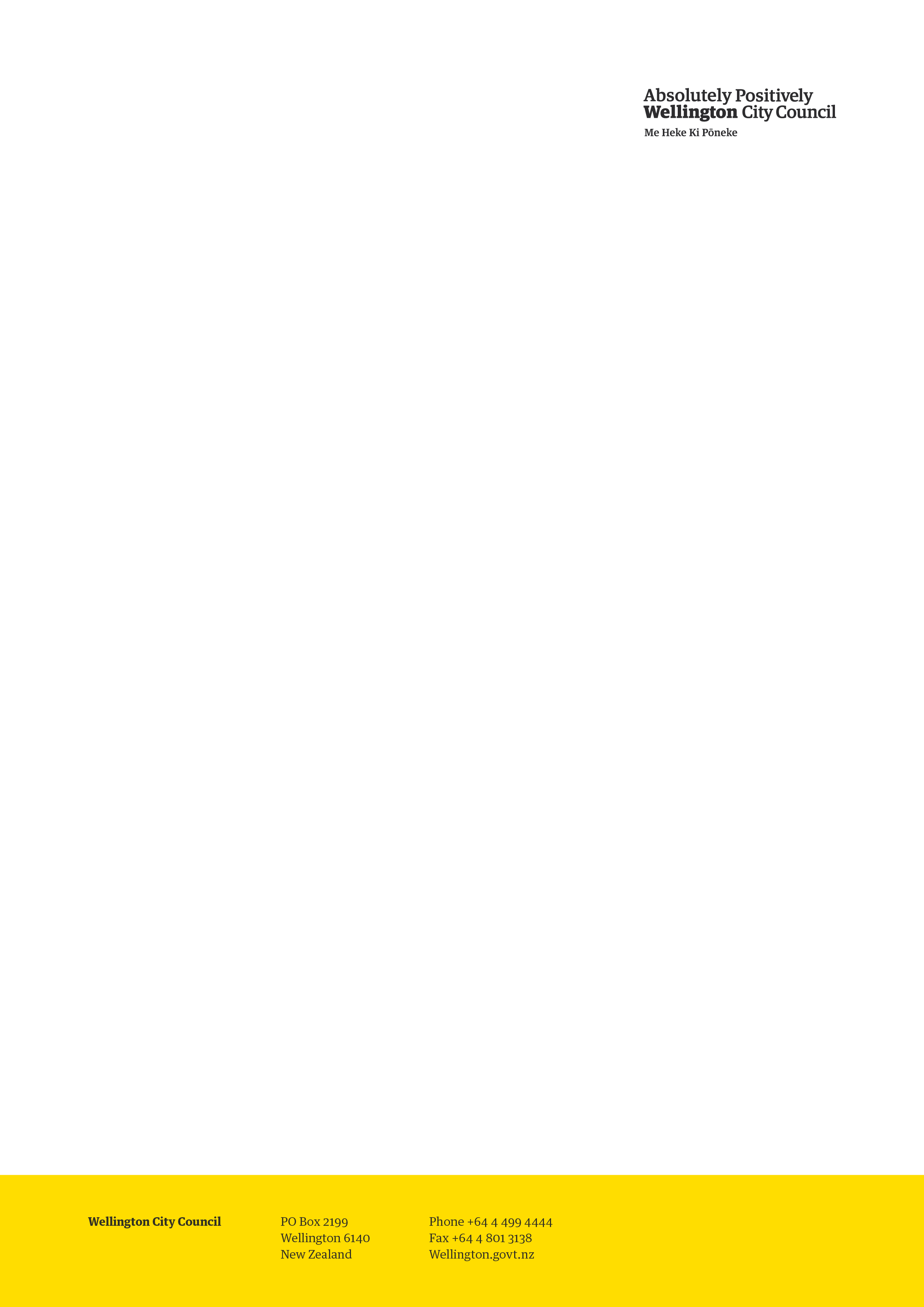
Below is the screenshot of the 5 minute (Green), and 10 Minute (Orange) walkable area to Raroa
Station:
The building heights in the walkable area of Raroa Station is a maximum building height of six
storeys
Wellington City Council | 2 of 10
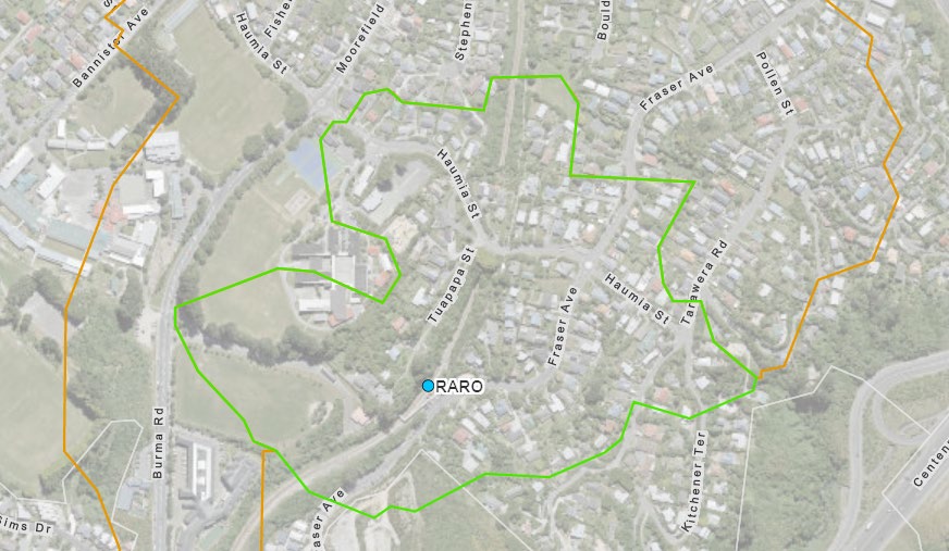
Below is the screenshot of the 5 minute (Green), and 10 Minute (Orange) walkable area to
Johnsonville Station:
The building heights in the walkable area of Johnsonville Station is a maximum building height of
eight` storeys.
For density ranges of the Draft Spatial Plan typology proposals see:
https://planningforgrowth.wel ington.govt.nz/__data/assets/pdf_file/0022/14953/PFG-Draft-
Spatial-Plan-Growth-Figures-25-September.pdf
7) Each location in Wel ington City that "within at least a walkable catchment of" "the edge of city
centre zones" as defined by Policy 3 (c)(i ) of the National Policy Statement on Urban Development
2020 as wel as the building heights and densities required by Policy 3.
7a) The WCC has not provided the building heights information for each location that is "within at
least a walkable catchment of "the edge of city centre zones" as requested.
7b) The WCC has not provided the building density information for each location that is "within at
least a walkable catchment of". ."the edge of city centre zones" as requested.
7c) The WCC has not provided the evidence used to support the extent of the walkable catchment
for each location that is "within at least a walkable catchment of". ."the edge of city centre zones"
as requested.
The City Centre zone is the National Planning Standards (8) Zone Framework Standard name for
the ‘Central Area zone’ in the operative District Plan. See the map builder ‘NPS-UD affected area’
which affects the inner suburbs of Aro Val ey, Mount Victoria, Mount Cook and Thorndon.
As explained in the Draft Spatial Plan, the building heights for this area is
at least six storeys within
a
walkable distance of the city centre and metropolitan centres, as wel as existing and planned
rapid transit stops. Instead, building
heights of up to three storeys are proposed in character sub-
areas, and a range of four-six storeys is proposed outside of these sub-areas, within a general
character area. Areas outside of the ‘general character overlay’ and within a walkable catchment
from the central city would have building heights of at least six storeys enabled as required by the
NPS-UD 2020.
Wellington City Council | 3 of 10

For density ranges of the Draft Spatial Plan typology proposals see:
https://planningforgrowth.wel ington.govt.nz/__data/assets/pdf_file/0022/14953/PFG-Draft-
Spatial-Plan-Growth-Figures-25-September.pdf
8) Each location in Wel ington City that "within at least a walkable catchment of". ."the edge of
metropolitan centre zones" as defined by Policy 3 (c)(iii) of the National Policy Statement on Urban
Development 2020 as wel as the building heights and densities required by Policy 3.
8a) The WCC has not provided the walkable catchment which is "within at least a walkable
catchment of" "the edge of metropolitan centre zones" for Kilbirnie as requested.
8b) The WCC has not provided the building heights information for each location that is "within at
least a walkable catchment of". ."the edge of metropolitan centre zones" as requested.
8c) The WCC has not provided the building density information for each location that is "within at
least a walkable catchment of". ."the edge of metropolitan centre zones" as requested.
8d) The WCC has not provided the evidence used to support the extent of the walkable catchment
for each location that is "within at least a walkable catchment of". ."the edge of metropolitan
centre zones" as requested.
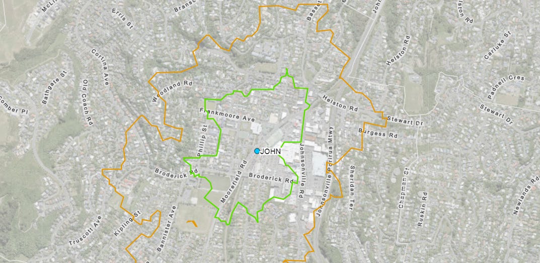
Below is the screenshot of the 5 minute (Green), and 10 Minute (Orange) walkable area for the
Kilbirnie Centre (Black).
The building heights in the walkable area of Kilbirnie is between one to two storeys.
The Council cannot provide you with the density at this point in time as the information doesn’t
exist. The Council would like to obtain feedback from the community on these matters and test
the application of the walking catchments model ed.
The Council has outlined in the Draft Spatial Plan that there are multiple hazard risks in Kilbirnie.
Because of this the council has not incorporated the NPS-UD intensification requirements for a
metropolitan centre at this time. As more research is obtained and work undertaken, the Council
will need to revisit this proposal for the final spatial plan.
For density ranges of the Draft Spatial Plan typology proposals see:
https://planningforgrowth.wel ington.govt.nz/__data/assets/pdf_file/0022/14953/PFG-Draft-
Spatial-Plan-Growth-Figures-25-September.pdf
Wellington City Council | 4 of 10
9) Each location in Wel ington City that is under "al other locations in the tier 1 urban
environment" as defined by Policy 3 (d) of the National Policy Statement on Urban Development
2020 as wel as the building heights and densities required by Policy 3.
9a) The WCC has not provided the walking catchment or UPS-UD Impacted Area for each location
that are locations as defined "al other locations in the tier 1 urban environment" as defined by
Policy 3 (d) as requested.
9b) The WCC has not provided the building heights information for each location that are locations
as defined "al other locations in the tier 1 urban environment" as defined by Policy 3 (d) as
requested.
9c) The WCC has not provided the building density information for each location that are locations
as defined under "al other locations in the tier 1 urban environment" as defined by Policy 3 (d) as
requested.
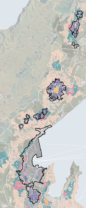
•This is the balance of the Wel ington urban area shown through housing typologies 1,2,3 and 4a
•This information is mapped and publicly available in the Draft Spatial Plan. See Appendix one: A
screenshot from the map builder.
• Also see the ‘Wel ington Outer Suburbs Assessment and Evaluation’ Pg 22 which has informed
the range of housing typologies applied. This is available online.
https://planningforgrowth.wel ington.govt.nz/resources1/documents
• For density ranges of the Draft Spatial Plan typology proposals see:
https://planningforgrowth.wel ington.govt.nz/__data/assets/pdf_file/0022/14953/PFG-Draft-
Spatial-Plan-Growth-Figures-25-September.pdf
10) Each location in Wel ington City that the WCC considers that it is necessary to modify the
building height or densities in order to provide for a qualifying matter under Policy 4 of the
National Policy Statement on Urban Development 2020 including, for each location:
• The qualifying matter including a copy of the evaluation report prepared under section 32 of
the Act in relation to the proposed amendment.
• The alternative building heights and densities proposed.
10a) The WCC has not provided qualifying matter information for each location where a qualifying
matter (as permitted under Policy 4) has been applied as defined by Policy 3 (d) as requested.
10b) The WCC has not provided the alternate building height information for each location where
a qualifying matter (as permitted under Policy 4) has been applied as defined by Policy 3 (d) as
requested.
10c) The WCC has not provided the alternate building density information for each location where
a qualifying matter (as permitted under Policy 4) has been applied as defined by Policy 3 (d) as
requested.
• This question is answered in part by the Council’s response to Question 7.
• Other qualifying matters the council has used include heritage areas (eg Aro centre), natural
hazards (eg Tinakori road).
• The Council does not propose any changes to the present heights in central area.
• A section 32 has not yet been prepared. It is not required for the Spatial Plan. Section 32
evaluation reports must and wil be prepared when the proposed District Plan is notified.
• For density ranges of the Draft Spatial Plan typology proposals see:
https://planningforgrowth.wel ington.govt.nz/__data/assets/pdf_file/0022/14953/PFG-Draft-
Spatial-Plan-Growth-Figures-25-September.pdf
Wellington City Council | 5 of 10
14) The specification for the walkable catchment for the Johnsonvil e metropolitan centre zone,
the criteria used to specify this catchment area and the evidence used to support the application
of this criteria.
14a) The WCC have determined under the previous District Plan that the extent of the 10-minute
walking catchment for Johnsonvil e as being the Johnsonvil e Medium Density Residential Area.
The Spatial Plan has proposed a much larger extent to be walkable. The area proposed by the
Spatial Plan as the walkable catchment for the Johnsonville metropolitian centre zone is different
from both the MDRA and the walking catchment from Johnsonvil e Station. The area of this
catchment area is yet to be provided.
14b) The criteria applied by the Spatial Plan to determine the walkable catchment for the
Johnsonvil e metropolitian centre zone is different from both the MDRA and the walking
catchment from Johnsonvil e Station. The criteria used to specify this catchment area and the
evidence used to support application of this criteria are yet to be provided.
• This is available online on the Planning for growth website.
o The requirement to enable building heights of at least six storeys within at least a
walkable catchment of rapid transit stops means a larger degree of intensification in
the fol owing areas: Tawa, Redwood, Linden, Johnsonville, Khandallah, Ngaio and
Crofton Downs. Further work is being undertaken around Kenepuru Station. The
Draft
Spatial Plan includes the fol owing:
At least six storeys buildings within a ten-minute walking catchment of the
Johnsonvil e railway station and the edge of the centre;
At least six storeys buildings within a ten-minute walking catchment of the Tawa
railway station; and
At least six storey buildings within a five-minute walking catchment of all other
railway stations.
• The Council used a ten minute walking catchment from the Johnsonvil e railway station
and centre, and from the Tawa railway station because the wide range amenities such as
public facilities, commercial and retail activities and services nearby have more potential to
support growth and help facilitate a well-functioning urban environment. For other
stations on the Johnsonville and Tawa railway lines, five-minute walking catchments have
been used reflecting the comparatively smaller range of amenities. The application of
these walking catchment ranges is open to community feedback.
• The Council received a number of submissions on the extent of walking catchments
through submissions on the Draft Spatial Plan. Both smal er and larger walking catchments
were requested. These wil be considered when finalising the spatial plan.
15) The specification for the walkable catchment for the Kilbirnie metropolitan centre zone, the
criteria used to specify this catchment area and the evidence used to support the application of
this criteria.
15a) Although the WCC claims it has applied the same walking catchment criteria used for
Johnsonville also to Kilbirnie, the walking catchment area for Kilbirnie was requested and is yet to
be provided by the WCC.
15b) As noted in 8a), the NPS-UD Impact area for Kilbirnie is also not on the WCC on-line Spatial
Plan map even though this area is impacted.
• Kilbirnie is presently identified as a Sub-Regional Centre in the operative District Plan. This
equates to a metropolitan centre in the national planning standards and for the application
of the NPS-UD.
• The Council modelled a ten-minute walkable catchment from the edge of the centre
boundary using the same modelling applied to the Johnsonville Metropolitan centre.
Wellington City Council | 6 of 10
• As explained on the Planning for Growth website:
o In Kilbirnie and Lyall Bay, there are a number of hazard issues relating to sea level rise,
flooding, ground shaking, liquefaction and tsunami. The Council considers these
hazards to be relevant ‘qualifying matters’ under the
NPS-UD. This may mean enabling
building heights of at least six storeys required by the
NPS-UD (because it is a
metropolitan centre) is not appropriate across these areas. The Council needs to do
further work to fully understand the implications of these hazards on the level of risk
for development in these areas beyond what is already proposed. This will inform
future decisions about what level of intensification is appropriate.
• The Draft Spatial Plan does not presently apply intensification direction Policy 3(c)(i ) of the
NPS-UD to Kilbirnie for the reasons outlined above.
Below is the screenshot of the 5 minute (Green), and 10 Minute (Orange) walkable area for the
Kilbirnie Centre (Black).
The building heights in the walkable area of Kilbirnie is between one to two storeys.
16) The criteria for specifying the walkable catchment for Medium density housing (type 3): 3-4
storey small apartment housing adjacent to suburban centres.
16a) While the WCC notes that “The Type 3 housing typology was not based solely on a walkable
catchment basis”, the walkable catchment information that was used was requested and is yet to
be provided by the WCC.
16b) As noted in 9(a), the NPS-UD Impact area is also not provided on the WCC on-line Spatial Plan
map even though these areas are impacted.
• The Type 3 housing typology was not based solely on a walkable catchment basis. It was
based on a heat map of amenity ‘enablers’ and hazards. A full explanation of the
methodology and criteria can be found in the Outer Suburbs Evaluation report available
online:
https://planningforgrowth.wel ington.govt.nz/resources1/documents
If you still require further clarification you can contact speak to John McSweeney Place Planning
Manager on 04 803 8557.
On 23 November 2020, you have also requested additional information for the 15 documents
released in IRO-10626. You have asked for:
• The date when the document was finalised by the WCC or, if not created by the WCC,
received by the WCC.
Wellington City Council | 7 of 10
• The author of the document or agency from which the document was sent (if not created
by the WCC).
• If the document was sent as an email attachment, a copy of the email to which the
document was attached.
• The recipient(s) of the document within the WCC for document 1, 6, 14 and 15.
• Where information has been withheld in a document, for each redaction, the grounds of
LGOIMA under which the WCC has chosen to withhold information.
Item Document name/description
When doc was finalised, author, who was
sent document.
1.
Summary - Recommended version of July 2020 – Place Planning team. Shared
the NPS-UD and Spatial plan
internally with Chief City Planner. Redacted
implications.
under section 7(2)(h) protects information
where it is necessary to enable the agency that
holds it to carry out commercial activities
without prejudice or disadvantage.
2.
2020 08 13 Steering Group - 21
August 2020 – Place Planning team.
Report
Documents lists receivers
3.
20200803 SPC Presentation - NPS UD August 2020 – Place Planning team. Receivers
and Draft Spatial Plan
of documents listed i
n minutes
4.
2020-08-06-agenda-spc
August 2020, Democracy Services Team.
Receivers of document listed
in agenda
5.
2020-08-06-minutes-spc
August 2020, Democracy Services Team.
Receivers of document listed
in minutes
6.
20200818 Presentation to Advisory
August 2020 – Place Planning team. Receivers
Groups Draft Spatial Plan
of document listed i
n minutes.
7.
Tawa Community Board agenda 10
September 2020 – Democracy Services team.
September 2020
Receivers of document listed
in agenda
8.
20200826 FINAL Tawa Community
August 2020 – Place planning team. Receivers
Board - Draft Spatial Plan
of document are members o
f Members of the
board.
9.
Cable Car - Email_Redacted
Details in email. Redactions are out of scope
for request.
10. Definition of rapid transit
Details in email.
11. Is the Cable Car Rapid Transit - email Details in email.
12. NPS decision and actions
Details in email.
13. Data on Kapiti and JVille Rail Lines
Details in email.
14. NZIA Presentation
August 2020 – Place Planning team. presented
to NZIA members who attended the
presentation.
15. NZPI 13 August Presentation
August 2020 – Place Planning team. Presented
to NZPI members who attended the
presentation.
On 30 November 2020 you rang and asked for further clarification regarding the Rapid Transit Stop
and/or Rapid Transit Service. You asked what was the prescribed Government rules and what
decision the Council made. The Council had a brief discussion with the Ministry for Environment
prior to the release of the Draft Spatial Plan where the Tawa and Johnsonvil e lines were discussed
as Rapid Transit Service/Stop. The Council then modelled either a five or ten minute walking
Wellington City Council | 8 of 10

catchment from the stations along these train lines to apply Policy 3 of the NPS-UD. The Council has
now received submissions on the Rapid Transit Service/Stop and wil consider these in the course
of finalising the Spatial Plan. There were no other documents found that would meet your request
apart from what has already been supplied to you.
Right of review
If you are not satisfied with the Council’s response, you may request the Office of the Ombudsman
to investigate the Council’s decision. Further information is available on the Ombudsman website,
www.ombudsman.parliament.nz.
Thank you again for your request, if you have any question please feel free to contact me.
Kind regards
Asha Harry
Assurance Advisor
Wellington City Council | 9 of 10
 Appendix one:
Wellington City Council | 10 of 10