Act
Information
Official
the
under
Released
Operational Plan Papakai 2017 - DOC-3007403
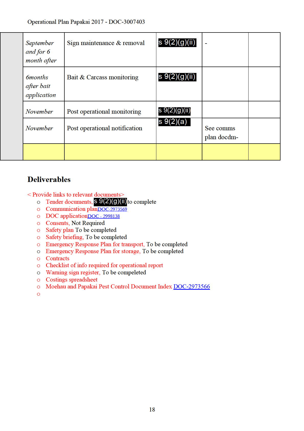
The operation is planned to take place in July- September 2017. This time has been chosen as the
best time to conduct the operation as possums are more vulnerable to poisoning in winter/ early
spring where alternative food sources are seasonally low.
Some of the treatment area shares a boundary with private pine plantations
Consideration has been given in terms of timing of the operation to ensure possums are not being
drawn into the production forest at the time of pine pollination which is around the month of August.
Limiting the re-invasion of possums from habitat adjacent or near the boundary supports the
conservation outcomes that this operation is looking to achieve. To aid with this, consideration has
been given to a coordinated effort with Waikato Regional Council (WRC) but has not amounted to a
joint operation. The author is liasing with the Mahakirau Forest Estate community located between
Act
the Goldfields (Kakatarahae) block and the 309 road, who have an effective on-going pest control
programme. Mahakirau Forest Estate Community have requested that they would like there block to
be included into the aerial operation, and have allowed the Dept of Conservation to use the back
section of the estate to carry out the helicopter operation from. Also the Te Mata private forestry
block which is adjacent to the Papakai block have been carrying and pest control mainly using traps
and cyanide.
Future pest control operations in this area will depend on initial control levels achieved from this
operation and on the rate of re-invasion from adjacent areas. It is expected that the possum
Information
population will take at least four years before they begin to have a measurable effect on the indicator
species. Operation are planned to be carried out every four year over the next 50year period.
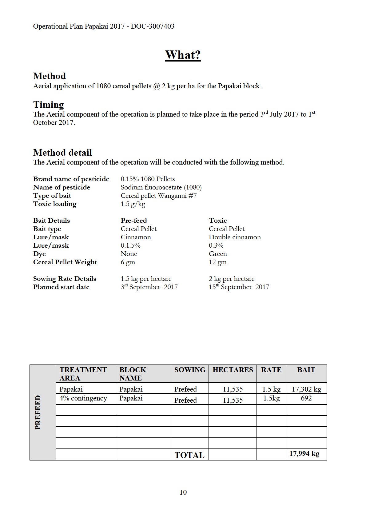
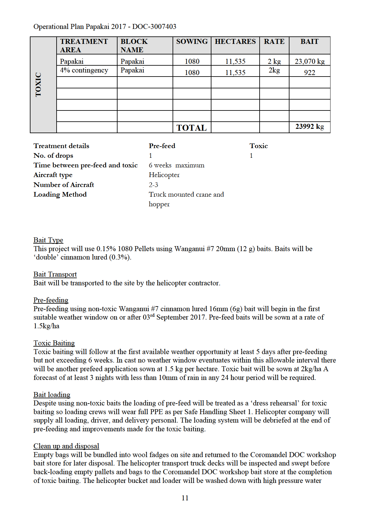
One application of 1.5 kg (6 gram bait per hectare of pre-feed cereal bait will be sown by helicopter
for the aerial operation. Following the pre-feed, 1080 will be applied at a rate of 2 kg per hectare,
Official
with a maximum window of 6 weeks between sowing the pre-feed and the 1080 baits. The
contingency plan if the 6week weather window is not available will be to re-sow the area the prefeed
bait at a rate of 1.5 kg per hectare The timing of the sowing of the 1080 baits will require a weather
the
window of three fine nights to achieve maximum toxin uptake.
Site description
The Papakai ecological area and Goldfield (Kakatarahae) block is in the Thames Ecological District.
under
The sanctuary is 27 km north of Thames, located in two large catchment areas that feed the Manaia
and the Kaimarama Rivers. Two prominent features include Kakatarahae (725m asl) on the eastern
boundary and Horomanga (574m asl) which is central to the block. Papakai ecological block runs
from the Tapu Coroglen road heading North West until it marries up with the Mania Kauri Sanctuary
(Kaakatarahae), the three main features in this area are Papaki (750m asl), Rapaki (694m asl) and
Pukeotahu (540m asl). The Papakai catchment area flows into two main rivers, TeMata to the West
and Ounuora to the East.
Released
Conservation Values
The Papakai ecological area contains a number of different systems in the one area
The sanctuary is the largest remaining stand of kauri on the Coromandel peninsula and is home to
Tanenui, the third largest kauri left standing in New Zealand. The sanctuary has an international
classification (IUCN 1).
The large number of big kauri dominate the landscape, surrounded by podocarp/hardwood forests
that have large mature stands of miro, rimu and rata, amongst kohekohe and tawa. King fern is
present in some areas.
2
Operational Plan Papakai 2017 - DOC-3007403
Korimako, tui, kereru, North Island kaka, piwakawaka and riroriro are all present.
The sanctuary has a population of North Island brown kiwi and long tail bats have been reported
there.
The forested catchments are home to giant kokopu, banded kokopu, short and long finned eels,
inanga and red finned bully.
The diversity of plant life throughout the reserve inspires numerous visits by botanical enthusiasts
throughout the year.
Manaia was gifted by Ngati Maru to Ngati Pukenga in recognition of assistance rendered by that Bay
of Plenty tribe during the “ musket wars “. This is one of the few large Maori owned areas in
Hauraki.
Manaia is the largest Maori community on the peninsula north of Thames. The people are of Ngati
Pukenga, Ngati Whanaunga and Ngati Maru tribes. The marae is Te Kou o Rehua.
Manaia was a rich resource area: “Ko Manaia, he pataka kai” (Manaia the food store). Fishing and
Act
mussel farming employ locals. Mangrove extension and siltation are problems in Manaia Harbour, as
in most other estuarine harbours of the peninsula.
The Manaia Forest Sanctuary, which contains 400 kauri trees, was established in 1972 after local
protest against planned logging.
Threatened species
Coromandel brown kiwi
Coromandel Brown Kiwi (CBK) are present in the operational area. CBK’s are the rarest of the
Information
North Island brown kiwi taxa with an estimated 900 pairs across the Coromandel. Kiwi densities are
highest in the northern regions of the Peninsula, however, birds in the Papakai region, represent
important genetic diversity.
Dwarf-greenhood orchid
The dwarf-greenhood orchid or
Pterostylis puberula is classified as Nationally Vulnerable. The
Official
monitored population consists of approximately 130 individuals. Rat control is one of the current
management prescriptions as rat herbivory is thought to be a threat. Past monitoring shows a
the
population spike co-inciding with aerial 1080 application in 2008.
Long-tailed bats
Long-tailed bats have been recently (2013) found along the Tapu-Coroglen Rd, Long-tailed bats are
likely the only native land mammal on the Coromandel. Searches continue for short-tailed bats, but
under
none have been found to date.
Dactylanthus taylorii/woodrose
Another interesting species is the native woodrose
Dactylanthus taylorii.
Dactylanthus is New
Zealand’s only totally parasitic flowering plant. It grows on the forest floor and parasitizes the roots
Released
of some 30 native species. This species used to be spread across the Peninsula and collected by
enthusiastic ornament hunters.
Dactylanthus dropped off the radar for nearly a 100 years.
The current known
Dactylanthus population on the Coromandel consists of only two clumps. Work
is underway to increase numbers through caging plants to exclude possums and hand pollination to
increase seed set. Given that this species is cryptic, however, there are likely to be many
undiscovered plants.
Dactylanthus are at high risk from possum browse as the inflorescences
produce copious sweet nectar. Unfortunately possums consume the entire inflorescence, eliminating
that plant’s ability to reproduce. Furthermore, rats consume the seeds reducing the reproductive
success of the
Dactylanthus population. Without pest control our
Dactylanthus population would be
at significant risk.
Other threatened plants
3
Operational Plan Papakai 2017 - DOC-3007403
Plumatochilos tasmanicum (Serious Decline)
Pimelea tomentosa (Nationally Vulnerable)
Psuedopanax laetus (Gradual Decline)
- The operational area includes the largest extent of this species in the Waikato Conservancy
Pittosporum kirkii (Serious Decline)
Marattia salicina (Serious Decline) – King fern
Epacris sinclairi (Natural y uncommon)
Act
Raukaua edgerleyi (Gradual Decline) – Raukawa
Information
Official
the
under
Released
4
Operational Plan Papakai 2017 - DOC-3007403
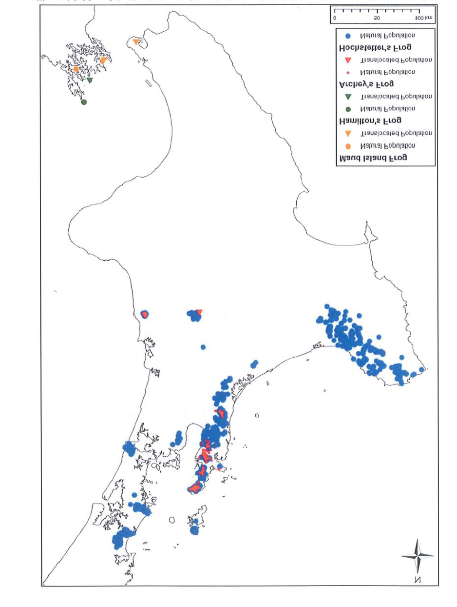
Archey’s frog
The Coromandel Peninsula is home to the majority of the threatened Archey’s frog range. The only
other places they are found include a small coastal forest block in the King Country, Maungatautari
and captive facilities such as the Auckland Zoo. The Coromandel represents the national stronghold
for Archey’s frog (see below).
Act
Information
Official
the
It has been proven that rat predation has a s
under ignificant impact on Archey’s frog populations and that
rat control has a positive impact (see Whareorino research).
Juvenile froglets on the back of an adult male were observed within the Papakai pest control
operational area during a monitoring session in early 2014. This was direct evidence of breeding
success.
Iconic species
In addition to high priority threatened species, there are also iconic species throughout the block.
Released
Kauri
The Coromandel Forest Park includes impressive stands of kauri. Prime examples are the Waiomu
Kauri Grove, Square Kauri and the Wainora Kauri. Kauri are a significant species, influencing
community species composition through alterations to soil chemistry. Kauri are under threat from
kauri dieback disease (Phytophthora Taxon Agathis), which has recently been confirmed on the
Coromandel for the first time. The kauri in the southern Coromandel were some of the first stands to
be extensively harvested in the 19th Century and so the current distribution is a small remnant of
what was once a magnificent ecosystem.
Freshwater fish
5
Operational Plan Papakai 2017 - DOC-3007403
Native freshwater fish have been recorded throughout the several catchments in the operational area
including:
Smelt
Torrentfish
Banded kokopu
Long-finned eels
Short-finned eels
Red-finned bullies
Koaro
Threats
The usual hosts of pests are present; these include pigs, goats, rats, hedgehogs, mice, possums, stoats,
Act
weasels and cats. Possum numbers have been measured in March 2017 at 5.9% RTC, 10% RTC
being the known trigger point for possum palatable trees in the area.
Goats and pigs are present on Central Coromandel and both cause damage to the forest ecosystem.
The Department of Conservation began goat control in the area in 1987, and intensively from 1993.
Monitoring of the forest under-storey has shown significant improvement.
Mustelids (weasels, ferrets and stoats) and feral cats are present. All four species threaten
conservation values by preying on vertebrate and invertebrate populations, but the most destructive is
the stoat. Stoats are adept tree climbers and, along with ship rats, will predate birds, nestlings, and
Information
eggs, as well as lizards and invertebrates within the canopy. Brown rats tend to be abundant along
water courses and, together with mice, are opportunists, eating both vegetation and animal matter.
Hedgehogs are also present, mainly preying on native invertebrates.
Domestic stock have access to one main section of the area, the Waikawau catchment. From this
point stock have travelled along old forestry roads a distance into the area. This issue is currently
being addressed through fencing
Official
Issues
the
Treatment area is under Treaty claim, which could raise some sensitive issues between local Iwi and
the Department. Due to sufficient consultation and engagement this should be limited.
Due to the rugged terrain and potential of heavy rainfall in the area there is the possibility of possum
carcasses washing down the river and on to the coast. Even though this is a small possibility is could
happen if the operation was to be conducted at another time of the year, to manage this in the case of
under
such a rain fall the beach, main water ways coming out of Manaia and surrounding area will be
monitored and the local population informed.
Some of the boundaries in the area around the operational area do have unfenced or sensitive areas,
this concern could be mitigated through consultation or movement of the operational boundary and
or stock.
Conflict with local pig hunting groups and the lack of access after the operation will be considered
during the consultation process, Bait and carcass monitoring will be put in place in order to possible
Released
shorten the stand down period of the area after the operation is conducted.
Other management at the site
Past:
Year
Operation Name
Control Method
Pestlink Ref.
2013
Possum control
Aerial 1080
1314HAU02
6
Operational Plan Papakai 2017 - DOC-3007403
2009/10
Possum control
Ground, Cyanide
2006/07
Central Coromandel and
Aerial 1080
Whenuakite Aerial
2002/03
Possum control
Ground, various
methods
1997/98
Possum control
Ground, various
methods
1994/95
Possum control
Ground, various
methods
2016
Goat Control
Ground, Aerial
Act
hunting
2012
Goat control
Ground hunting
2001/02
Goat control
Ground hunting
1999/00
Goat control
Ground hunting
1997/98
Goat control
Ground hunting
1996/97
Goat control
Ground hunting
1994/95
Goat control
Ground hunting
1993/94
Goat control
Ground hunting
Information
Official
the
under
Released
7
Operational Plan Papakai 2017 - DOC-3007403
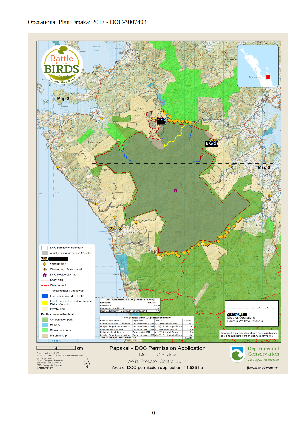
Where?
Map
Act
Information
Official
the
under
Released
8
Act
Information
Official
the
under
Released
Act
Information
Official
the
under
Released
Act
Information
Official
the
under
Released
Operational Plan Papakai 2017 - DOC-3007403
after first removing any visible pellets remaining. The loading site itself will be fenced off. Fencing
and loading site signs will remain in place until 50mm of rain has fallen on the site. Contaminated
PPE will be disposed with empty toxic bait bags.
Outcome and Result Monitoring
Result
When monitoring the effectiveness of the operation, it is considered
monitoring
essential to measure:
• the abundance of possums in a treatment area prior to control
(influences choice of control technique) (5.9% RTC current
March 2017.
• whether the operation has reduced possum abundance to the
Act
target residual catch rate.
The aerial component of the operation the Papakai block will be set
at 2% RTC. The monitoring of this will be conducted by contractors
and carried out in a robust sampling method of 5 plots with 5 lines
in each random selected location. The lines will be carried in
accordance with the monitoring protocol (NPCA 2005). The reason
for this alternative method is because of access problems, steepness
Information
of the terrain, and cost saving.
Outcome
Vegetation monitoring to assess the achievement of outcome targets
monitoring
will be carried every 5 years and results analysed to identify
changes in forest health. Vegetation monitori
Official ng focuses on a few
plant species (indicator species) known to be vulnerable to possum
damage. Part of the operation’s success will be assessed using
the
vegetation monitoring results. This information will assist decisions
on the timing of future possum control. Methods to be used are:
• Foliar browse index: assessment.
under
Released
How?
Consents required
1. Landowner or occupier consent
Yes
No
12
Operational Plan Papakai 2017 - DOC-3007403
2. Resource consent
Yes
No
3. Public health permission
Permission
Notification
Not required
4. DOC permission
Yes (operation involves pesticides)
No (traps or hunting only)
5. EPA permission
Yes
No
Act
Information
Official
the
under
Released
CIMS Structure
CIMS Structure
13

Act
Information
Official
the
under
Released
Act
Information
Official
the
under
Released
Act
Information
Official
the
under
Released
Act
Information
Official
the
under
Released
Act
Information
Official
the
under
Released