Act
Information
Official
the
under
Released
Consideration has been given in terms of timing of the operation to ensure possums
are not being drawn into the production forest at the time of pine pollination which is
around the month of August.
Limiting the re-invasion of possums from habitat adjacent or near the boundary
supports the conservation outcomes that this operation is looking to achieve. To aid
with this, consideration has been given to a coordinated effort with Waikato Regional
Council (WRC) but has not amounted to a joint operation. The author is liasing with
the Mahakirau Forest Estate community located between the Goldfields
(Kakatarahae) block and the 309 road, who have an effective on-going pest control
programme. Also the Te Mata private forestry block which is adjacent to the Papakai
block with a cyanide operation run by the consortium.
Future pest control operations in this area will depend on initial control levels Act
achieved from this operation and on the rate of re-invasion from adjacent areas. It is
expected that the possum population will take at least five years before they begin to
have a measurable effect on the indicator species.
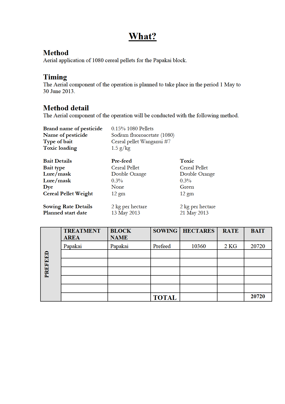
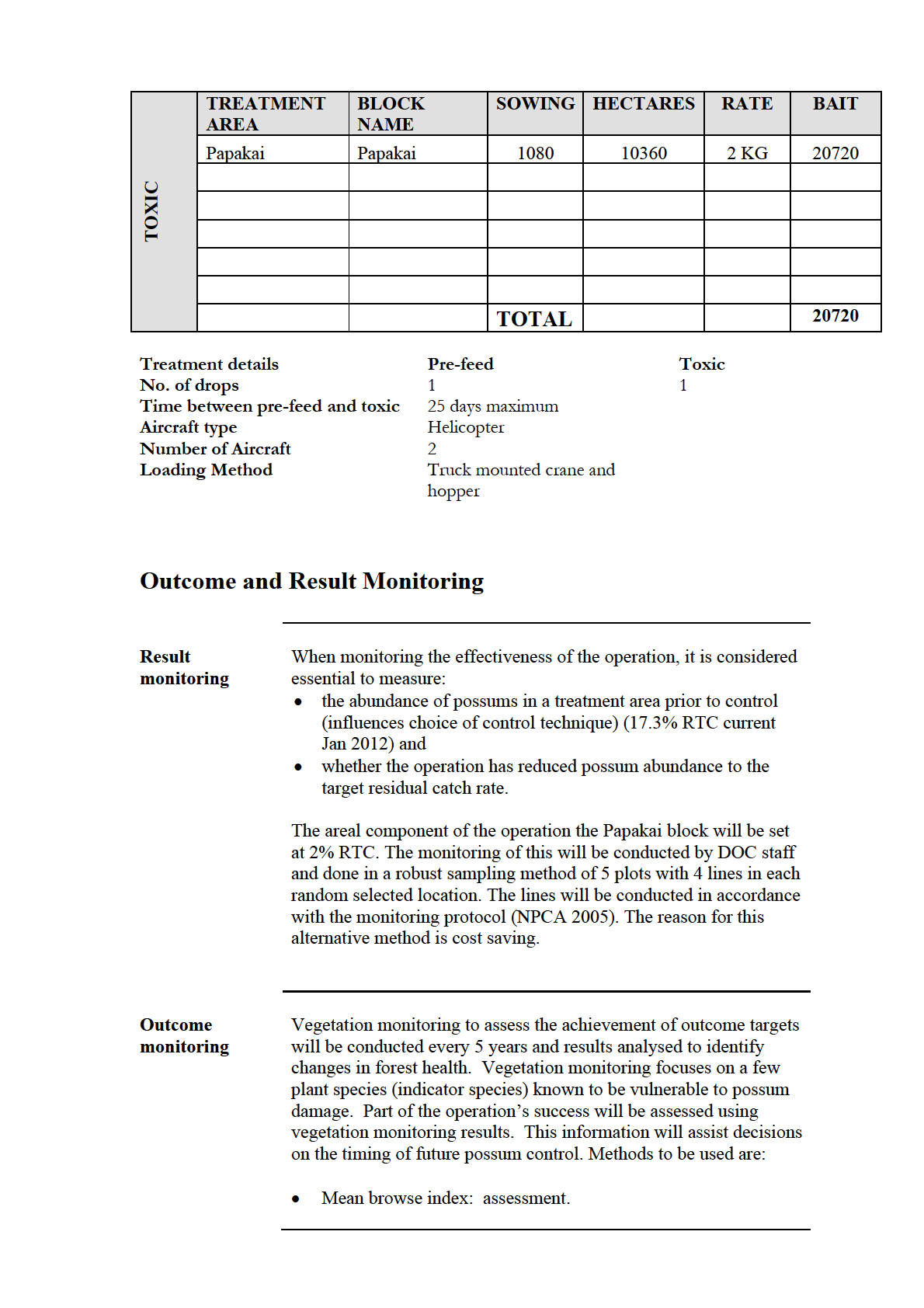
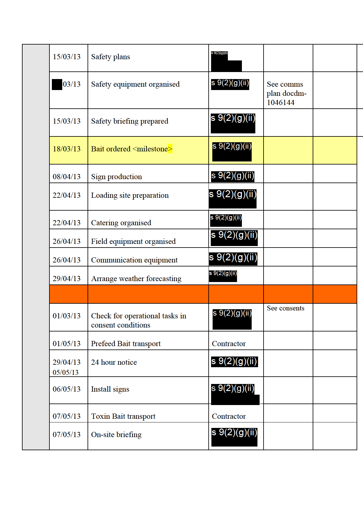
One application of 2 kg per hectare of pre-feed cereal bait will be sown by helicopter
for the aerial operation. Following the pre-feed, 1080 will be applied at a rate of 2 kg
per hectare, with a maximum window of 25 days between sowing the pre-feed and the
1080 baits. The timing of the sowing of the 1080 baits will require a weather window
Information
of three fine nights to achieve maximum toxin uptake.
Site Description
The Papakai ecological area and Goldfield (Kaakatarahae) block is in the Thames
Official
Ecological District. The sanctuary is 27 km north of Thames, located in two large
catchment areas that feed the Manaia and the Kaakatarahae rivers. Two prominent
features include Kaakatarahae (725m asl) on the eastern boundary and Horomanga
the
(574m asl) which is central to the block. Papakai ecological block runs from the Tapu
Coroglen road heading North West until it marries up with the Mania Kauri Sanctuary
(Kaakatarahae), the three main features in this area are Papaki (750m asl), Rapaki
(694m asl) and Pukeotahu (540m asl). The Papakai catchment area flows into two
under
main rivers, TeMata to the West and Ounuora to the East.
(Reference to AEE DOCDM-1150929)
Conservation Values
Released
The Papakai ecological area contains a number of different systems in the one area
The sanctuary is the largest remaining stand of kauri on the Coromandel peninsula
and is home to Tanenui, the third largest kauri left standing in New Zealand. The
sanctuary has an international classification (IUCN 1).
The large number of big kauri dominate the landscape, surrounded by
podocarp/hardwood forests that have large mature stands of miro, rimu and rata,
amongst kohekohe and tawa. King fern is present in some areas.
Korimako, tui, kereru, North Island kaka, piwakawaka and riroriro are all present.
The sanctuary has a population of North Island brown kiwi and long tail bats have
been reported there.
The forested catchments are home to giant kokopu, banded kokopu, short and long
finned eels, inanga and red finned bully.
The diversity of plant life throughout the reserve inspires numerous visits by botanical
enthusiasts throughout the year.
Manaia was gifted by Ngati Maru to Ngati Pukenga in recognition of assistance
rendered by that Bay of Plenty tribe during the “ musket wars “. This is one of the few
large Maori owned areas in Hauraki.
Manaia is the largest Maori community on the peninsula north of Thames. The people
are of Ngati Pukenga, Ngati Whanaunga and Ngati Maru tribes. The marae is Te Kou
o Rehua.
Manaia was a rich resource area: “Ko Manaia, he pataka kai” (Manaia the food store).
Fishing and mussel farming employ locals. Mangrove extension and siltation are
problems in Manaia Harbour, as in most other estuarine harbours of the peninsula.
The Manaia Forest Sanctuary, which contains 400 kauri trees, was established in 1972
after local protest against planned logging.
Act
Threats
The usual hosts of pests are present; these include pigs, goats, rats, hedgehogs, mice,
possums, stoats, weasels and cats. Possum numbers have been measured in Jan 2012
in the Goldfields (Kaakatarahae) block and have come back at 17.3% RTC, 10% RTC
being the known trigger point for possum palatable trees in the area.
Goats and pigs are present on Central Coromandel and both cause damage to the
forest ecosystem. The Department of Conservation began goat control in the area in
1987, and intensively from 1993. Monitoring of the forest under-storey has show
Information n
significant improvement.
Mustelids (weasels, ferrets and stoats) and feral cats are present. All four species
threaten conservation values by preying on vertebrate and invertebrate populations,
but the most destructive is the stoat. Stoats are adept tree climbers and, along with
ship rats, will predate birds, nestlings, eggs, lizards and inve
Official rtebrates within the
canopy. Brown rats tend to be abundant along water courses and, together with mice,
are opportunists, eating both vegetation and animal matter. Hedgehogs are also
the
present, mainly preying on native invertebrates.
Domestic stock have access to one main section of the area, the Waikawau catchment.
From this point stock have travelled along old forestry roads a distance into the area.
This issue is currently being addressed through fencing
under
Issues
Treatment area is under Treaty claim, which could raise some sensitive issues
between local Iwi and the Department. Due to sufficient consultation and engagement
this should be limited.
Due to the rugged terrain and potential of heavy rainfall in the area there is the
possibility of possum carcasses washing down the river and on to the coast. Even tho
Released
this is a small possibility is could happen if the operation was to be conducted at
another time of the year, to manage this in the case of such a rain fall the beach, main
water ways coming out of Manaia and surrounding area will be monitored and the
local population informed.
Some of the boundaries in the area around the operational area do have unfenced or
sensitive areas, this concern could be mitigated through consultation or movement of
the operational boundary and or stock.
Conflict with local pig hunting groups and the lack of access after the operation will
be considered during the consultation process, Bait and carcass monitoring will be put
in place in order to possible shorten the stand down period of the area after the
operation is conducted.
Other management at the site
Past:
Year
Operation Name
Control Method
Pestlink Ref.
2009/10
Possum control
Ground, Cyanide
2006/07
Central Coromandel and
Aerial 1080
Whenuakite Aerial
2002/03
Possum control
Ground, various
methods
1997/98
Possum control
Ground, various
methods
1994/95
Possum control
Ground, various
Act
methods
2012
Goat control
Ground hunting
2001/02
Goat control
Ground hunting
1999/00
Goat control
Ground hunting
1997/98
Goat control
Ground hunting
1996/97
Goat control
Ground hunting
1994/95
Goat control
Ground hunting
1993/94
Goat control
Ground hunting
Information
Official
the
under
Released
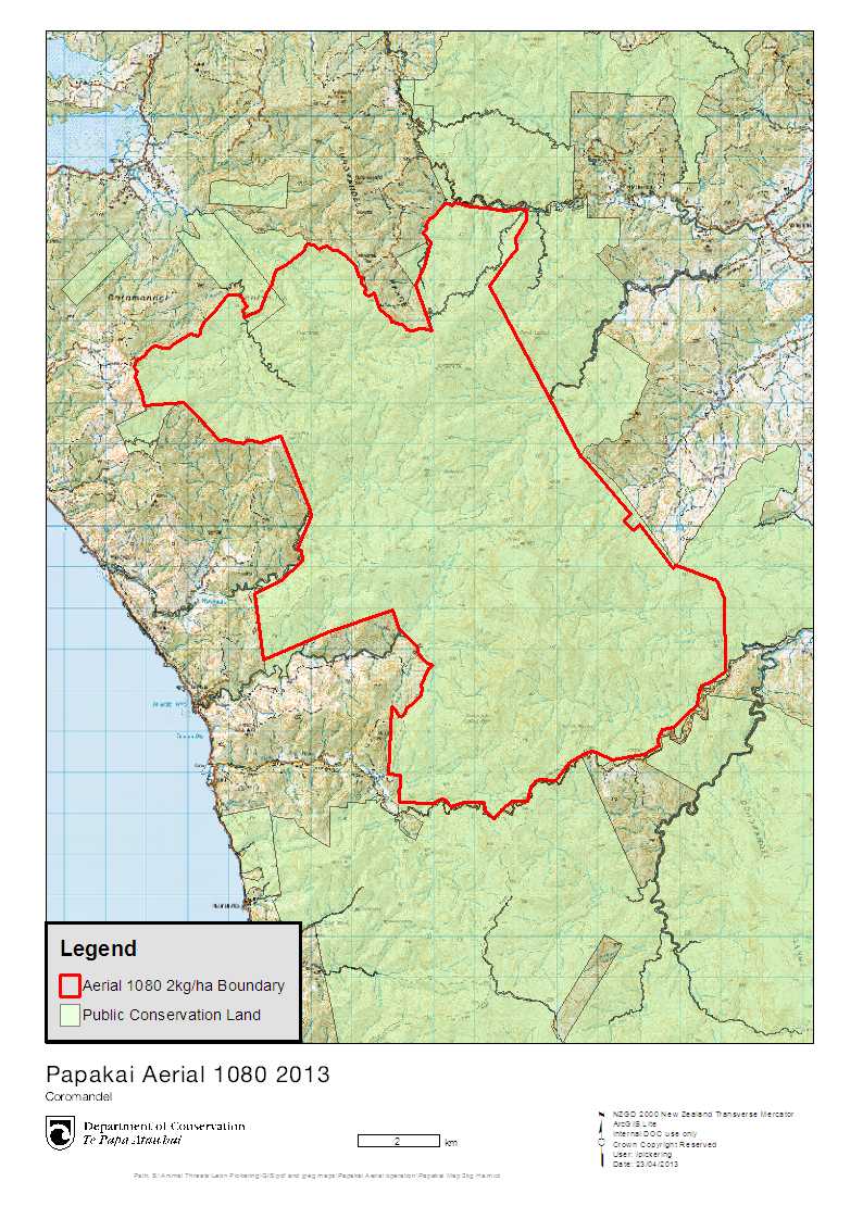 Where?
Act
Information
Official
the
under
Released
Act
Information
Official
the
under
Released
Act
Information
Official
the
under
Released
Act
Information
Official
the
under
Released
Act
Information
Official
the
under
Released
Act
Information
Official
the
under
Released
Act
Information
Official
the
under
Released
Act
Information
Official
the
under
Released