Preserving the Nation’s Memory Project
Climate change – sea level rise and hydrological hazards
5. The report acknowledges the effects of climate change and the changing r sk and
uncertainty on coastal erosion and rising sea levels as a result. Risk management and
planning is strongly recommended.
6. The report notes that sea levels wil rise however it is unknown when this wil
happen. The report has model ed a number of scenarios that describe the potential
impact of a range of rising sea levels on Wellington harbour refer Table 4 on page
18). As an example, over the next 50 years:
• If a 30cm sea level rise occurs, the consequences would be that, what is
currently a 1%AEP event (annual exceedance probability for 1 in 100 year
event) would be expected to occur at least once a year.
• If the sea level rises 50cm, the consequence of this would be that the current
1%AEP event, would occur approximately twice per month.
7. The report also identifies extreme weather and rainfall events as most likely to
impact Archives Wellington and the Thorndon Precinct in the future, as climate
change is expected to impact on the volume and frequency of rainfal s in New
Zealand. This may increase the risk of flooding of the existing Mulgrave Street facility
as storm water pipes will need to cope with the increased volume of rainfall.
8. The report notes that the risk of coastal inundation on low lying ground is predicted
the Official Information Act 1982
to be significantly exacerbated over the next 50 years by rising sea levels; and there is
an increased risk of flooding due to increased rainfall, particularly affecting the
existing lower elevation of the Mulgrave Street facility
9. The PtNM project has calculated whole-of-life costs for 25 years. The business case
timeline indicates the completion of the redeveloped Mulgrave Street facility in
2026, if the assumption is a building life expectancy of 50 years, this would take the
building life span to 2076.
Release
In-Confidence
Page 2 of 4
Preserving the Nation’s Memory Project
Peter Murray
DCE Information and Knowledge Services
/
/
the Official Information Act 1982
Release
In-Confidence
Page 3 of 4
Preserving the Nation’s Memory Project
The Department of Internal Affairs
Te Tari Taiwhenua
Appendix 1: PtNM 10 Mulgrave Street Hazard Assessment
report
the Official Information Act 1982
Release
In-Confidence
Page 4 of 4
Department of Internal Affairs
Preserving the Nation's Memory
10 Mulgrave Street
Hazard Assessment
the Official Information Act 1982
Release
3
Contents
Executive Summary ...................................................................................................... .. ............ 4
1
Introduction .................................................................................................... ... ................. 6
2
The Site ..................................................................................................... ........................... 6
2.1 Site Location ................................................................................ .. ............................ 6
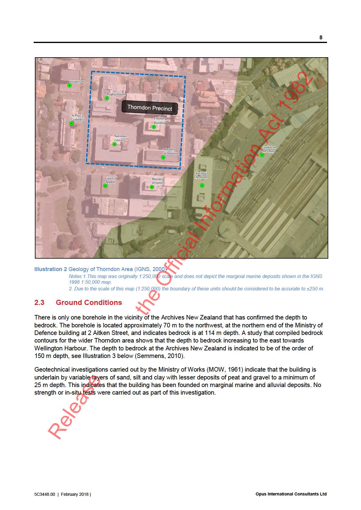
2.2 Geology ........................................................................................................................ 7
2.3 Ground Conditions .................................................................. .................................... 8
2.4 Site Class ............................................................................ .... ................................... 9
3
Hazards ................................................................................................................................. 9
3.1 Hazards Considered ................................................. ................................................. 9
3.2 Natural Hazards ..................................................... ... ............................................... 10
3.3 Anthropogenic Hazards ...................................... ... ................................................... 10
4
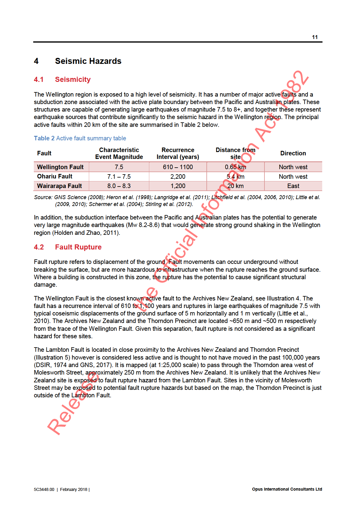
Seismic Hazards ............................................... .... ........................................................... 11
4.1 Seismicity .............................................. ................................................................... 11
4.2 Fault Rupture ........................................ .. ................................................................. 11
4.3 Ground Shaking ................................... .. .................................................................. 13
4.4 Liquefaction ................................. ... ... ..................................................................... 13
4.5 Tsunami ..................................... . . ........................................................................... 14
5
Storm Hazards ................................. ................................................................................ 16
5.1 Flooding ............................... . .................................................................................... 16
5.2 Storm Surge and Coastal Inundation .......................................................................... 17
5.3 Climate Change .......... ... ......................................................................................... 17
the Official Information Act 1982
6
Anthropogenic Hazards..................................................................................................... 20
6.1 Urban Fire ................................................................................................................... 20
6.2 Petroleum and hazardous substance storage ............................................................. 20
6.3 Transportation incidents .............................................................................................. 21
6.4 Contaminated Land .................................................................................................... 21
7
Conclusions ...................................................................................................................... 22
8
References ......................................................................................................................... 24
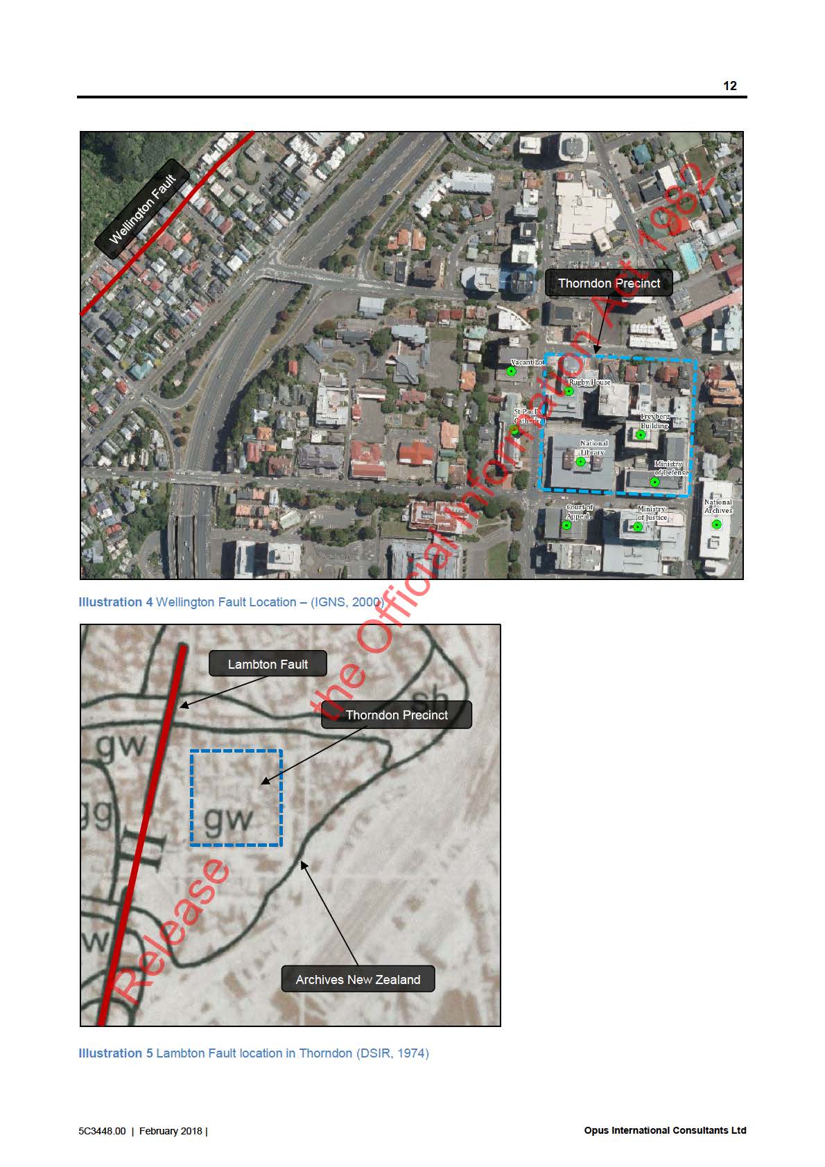
Figures
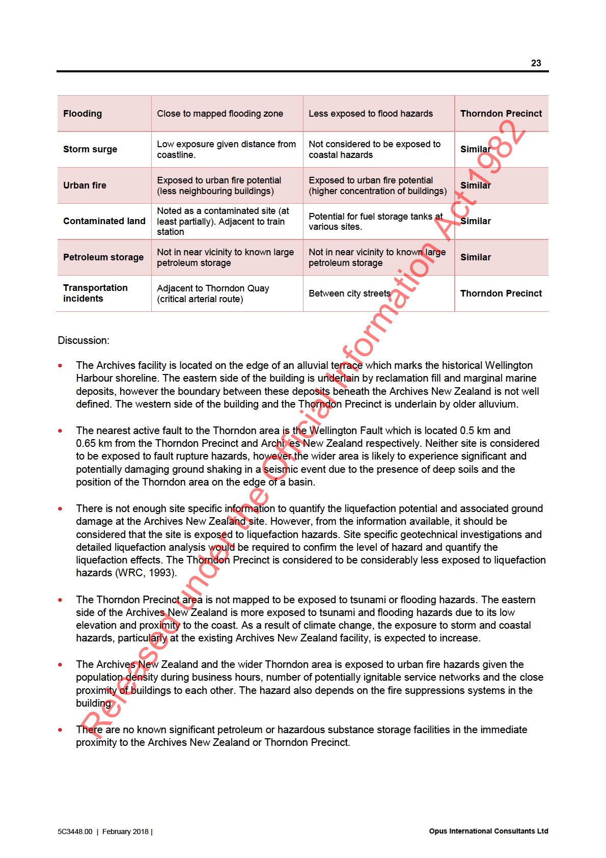
Figure 1 – Archives New Zealand Location Plan
Figure 2 – Wellington Harbour Reclamation Map
Release
5C3448.00 | February 2018 |
Opus International Consultants Ltd
link to page 8
5
indicate that higher levels of ground shaking were experienced within marine deposits and young al uvium,
underlying the eastern side of the Archives New Zealand building, than the older alluvium underlying the
western side of the building and the Thorndon Precinct area.
Exposure to liquefaction hazards is expected to be more localised, due to the variable nature of the marine
and alluvial deposits and possible reclamation fil which underlie a large area of Thorndon and a portion of
the Archives New Zealand building. Historical logs for the Archives New Zealand facility indicate that there
are potential y liquefiable layers and soft peats which could lead to settlement. However, there is not
adequate geotechnical data to confirm the level of liquefaction hazard and site specific investigation and
analysis is required to quantify and liquefaction effects. The Thorndon Precinct area is expected to be much
less vulnerable to liquefaction and settlement given the older al uvium present in this area.
The eastern (Thorndon Quay) side of the Archives New Zealand is more exposed than the western side or
the Thorndon Precinct area to storm and tsunami hazards, given the closer proximity to the shoreline and the
low lying nature of the reclaimed ground surface. The Archives New Zealand building is located on the cusp
of two tsunami evacuation zones. It is recognised that due to climate change, there is both a changing risk
exposure from coastal storm and erosion events and also a level of uncertainly regarding future rates of sea-
level rise. The effects of which wil likely increase the exposure to storm and coastal hazards, particularly at
the existing Archives New Zealand facility.
Anthropogenic hazards are generally more localised than natural hazards, however they can also lead to
building or infrastructure damage and potential loss of life. Exposure to anthropogenic hazards such as
urban fire, explosion from hazardous substances or contaminated land is general y similar across the
Archives New Zealand and Thorndon Precinct areas, as both areas are in close proximity to other buildings
(including their relevant electrical and mechanical services) are highly populated (during business hours)
and are al in the vicinity of potential zones of soil contamination. The exception is the eastern (Thorndon
Quay) side of the Archives New Zealand which is potential y more exposed to transportation hazards. This is
due to Thorndon Quay being a critical arterial route for Wellington City and therefore has a higher volume of
heavy vehicle traffic and as it is also adjacent to the railway yard and train station, which exposes it to rail
incidents.
the Official Information Act 1982
Release
5C3448.00 | February 2018 |
Opus International Consultants Ltd
link to page 11
6
1
Introduction
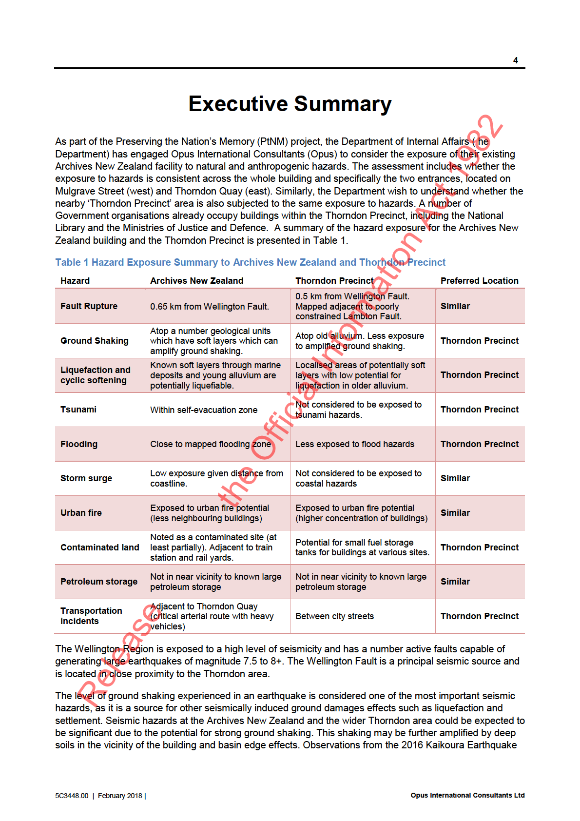
As part of the Preserving the Nation’s Memory (PtNM) project, the Department of Internal Affairs (the
Department) wish to assess the exposure of their existing Archives New Zealand facility and the Tho ndon
Precinct area to hazards.
The Department has engaged Opus International Consultants (Opus) to undertake an assessment to:
Determine the hazards that could affect the facility;
Determine whether there is any difference in exposure to hazards to the various entrances of the
building (Mulgrave Street and Thorndon Quay) and;
Assess the ‘Thorndon Precinct’ area to determine whether there are any locations in the immediate
vicinity which are exposed to a lower level of hazards than the Archives New Zealand at10 Mulgrave
Street.
This assessment encompasses both natural hazards, which are natural y occurring physical phenomena
such as earthquakes or flooding, and anthropogenic hazards, which occur as a result of human influence
such as hazardous substances fire or explosions.
This report presents the findings of this hazard assessment of the Archives New Zealand facility and the
Thorndon Precinct.
2
The Site
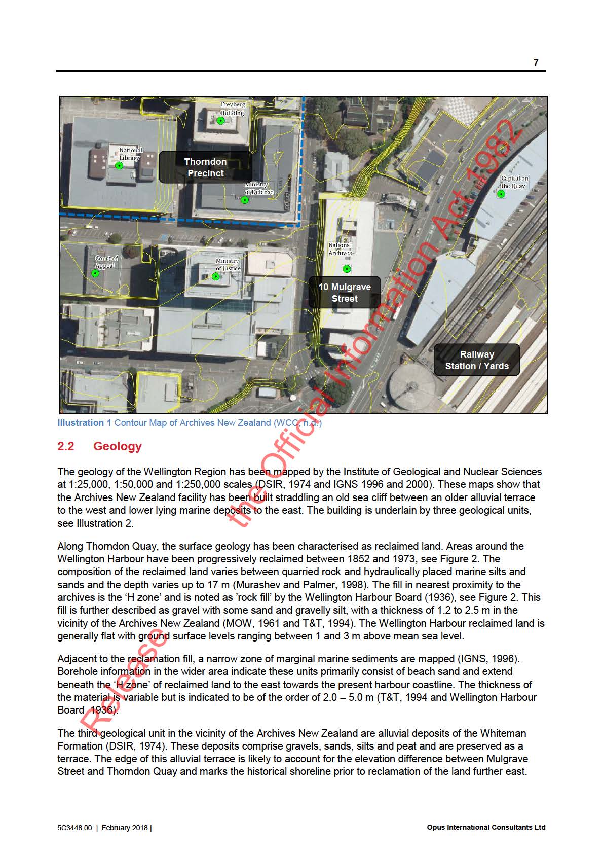
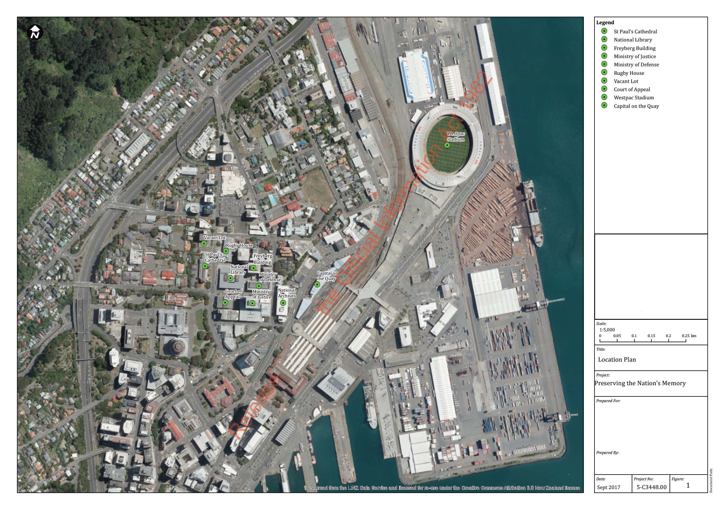
2.1 Site Location
The Archives New Zealand building is located at 10 Mulgrave Street, Thorndon (see Figure 1). There are two
entrances to the building; the main public entrance on Mulgrave Street near the intersection with Aitken
Street and the loading bay entrances on Thorndon Quay. The Thorndon Quay entrance is low lying on
reclaimed land and is two storeys lower than Mulgrave Street which marks the edge of an alluvial terrace.
The ground surface at the two entrances has an elevation difference of approximately 9 m. The Mulgrave
entrance is ~11 m above sea level and Thorndon Quay at ~2 m above sea level, see
Illustration 1 (WCC,
n.d.).
the Official Information Act 1982
The Archives New Zealand is located in close proximity to an area described as the ‘Thorndon Precinct’. This
area encompasses the National Library and a number of other Government occupied buildings such as the
Ministry of Defence and the Ministry of Justice, see Figure 1.
Release
5C3448.00 | February 2018 |
Opus International Consultants Ltd
link to page 12
link to page 13
10
3.2 Natural Hazards
A. Seismic hazards
a. Fault rupture
b. Ground shaking
c. Slope failure
d. Liquefaction
e. Tsunami
B. Storm hazards
a. Flooding
b. Storm surge and coastal inundation
C. Volcanic hazards
Natural sea cliff slopes in the vicinity of the Archives New Zealand facility accommodate an elevation
difference of ~9 m between Mulgrave Street and Thorndon Quay, with the slope faces bound by retaining
structures. Consequently, earthquake and storm induced slope instabi ity is not considered as an issue for
the building, however the performance of these walls in a seismic event could be critical to performance of
the building.
Volcanic hazards have not been considered in this assessment as they are not regarded as a significant
hazard in the Wellington Region. The nearest volcanic centre is the Central Plateau and any far reaching
effects that may occur from a volcanic event here are not likely to significantly impact the Wellington region.
Any effects (eg ash fall) that do affect the region are considered to be consistent across the wider Thorndon
area including the Archives New Zealand building and the Thorndon Precinct.
Wild fire is not considered in this assessment as he Archives New Zealand and Thorndon Precinct areas are
both within an urban area where wild fire is not considered as a hazard.
Cyclones are more common in higher latitudes of New Zealand as they originate from the tropics (Sinclair,
2002). As they advance poleward, the can ose characteristic hurricane features and for this reason, can be
considered less of a hazard for the Wellington Region. It is expected that adverse weather effects that could
affect the Archives facility wil have a consistent impact across the wider Thorndon area. Consequently,
cyclones have been excluded from this assessment.
the Official Information Act 1982
3.3 Anthropogenic Hazards
D. Urban fire
E. Petroleum and hazardous substance storage
F. Transportation incidents (road, rail, air)
G. Contaminated land
Military hazards are not considered in this assessment as there are no known military facilities in the vicinity
of the Archives New Zealand building. However, it is noted that a Ministry of Defence office building is
located within the Thorndon Precinct area, and close to the Archives New Zealand building at 10 Mulgrave
Street.
Security ssues have been omitted from this assessment. It is considered that the Department wil already
have information detailing security issues regarding their existing facilities in the area (Archives New Zealand
Release
and Library) and the exposure to potential security hazards wil be consistent across the wider Thorndon
area.
Detailed descriptions of these hazards considered are provided in the following sections.
5C3448.00 | February 2018 |
Opus International Consultants Ltd
link to page 15 link to page 16 link to page 16
13
4.3 Ground Shaking
Ground shaking is the intensity of shaking that is experienced during an earthquake. It varies across regions
as it is influenced by topography, geology and the earthquake source. Intensive ground shaking can cause
buildings and infrastructure to collapse or be significantly damaged. Ground shaking can be considered as
the most important seismic hazard as it is the source for a number of other earthquake hazard phenomena.
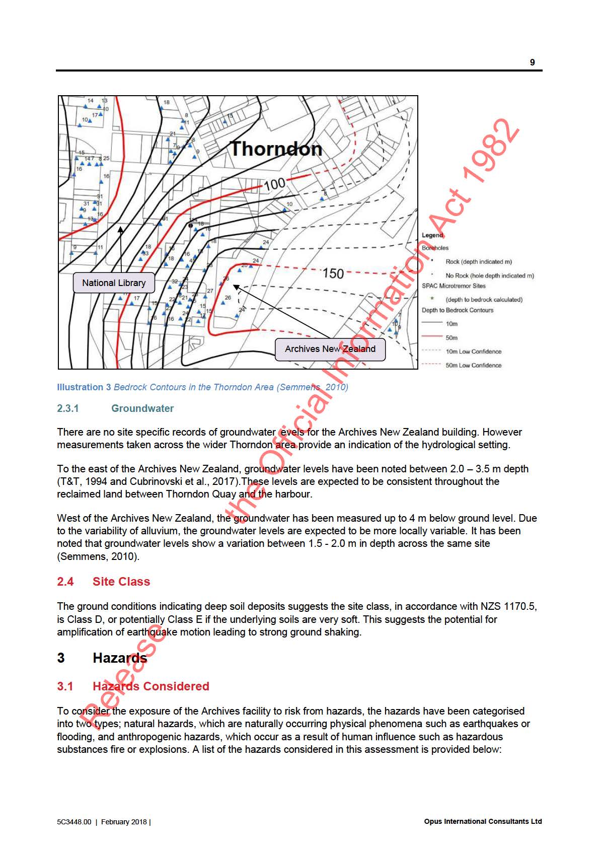
According to Semmens (2010), the Archives New Zealand facility and surrounding area in Thorndon has a
moderate potential for ground shaking amplification. This is because it is underlain by >150 m of soil
deposits. Sites underlain by soils, as opposed to sites located on rock, tend to damp out high frequency
motion and amplify long period motion. When the amplified period is close to the natural period of a
structure, the ground motion can cause severe damage.
Ground shaking can also be amplified through basin edge effects. The Thorndon Precinct and Archives New
Zealand are located in close proximity to the edge of the Thorndon Basin, which is bound by the Wellington
Fault. When the seismic waves reach the basin edge they can be reflected and result in amplification of
ground shaking. The Archives New Zealand facility is also located along a sea cliff which marks the
boundary of older terrace alluvium with softer recent al uvial and marine deposits and reclamation fil . These
younger, softer sediments along Thorndon Quay may experience more locally amplified shaking compared
to the older terrace where the Thorndon Precinct is located.
Evidence of amplified ground shaking in the Thorndon area was observed during the
Mw7.8 Kaikoura
Earthquake which occurred in November 2016. The peak ground accelerations (PGA) measured within soil
sites in the Thorndon Basin where significantly higher comparatively to sites underlain by rock. Strong
ground shaking was experienced along Thorndon Quay at the Thorndon Fire Station building which is
representative of the situation of the Archives New Zealand facility (Geonet, 2016).
4.4 Liquefaction
4.4.1 Available Geotechnical Information
An overview of the potential exposure to liquefaction hazards has been undertaken by reviewing
geotechnical information available for the Archives New Zealand and the surrounding area. Intrusive
geotechnical information was predominantly retrieved from our records, the Wellington City Council archives
and public databases. Historical geotechnical logs were reviewed for the following buildings (Figure 1):
the Official Information Act 1982
34 Thorndon Quay - Capital Gateway complex
10 Mulgrave Street – Archives New Zealand
19 Aitken Street – Ministry of Justice (also known as Vogel House)
2 Aitken Street – Defence House
Corner Aitken and Molesworth Street – Court of Appeal, Ministry of Justice
20 Aitken Street – Freyberg House
70 Molesworth Street – National Library
61 Molesworth Street – Vacant building site
It is important to note that while a number of borehole logs were reviewed in this assessment, no
geotechnical analysis was undertaken. The historical logs available for the Archives New Zealand were
undertaken circa 1961 and do not include any in situ testing or groundwater data. As such, the exposure to
liquefaction hazards discussed in the following section is based on the soil descriptions provided and is a
qualitative assessment only.
Release
5C3448.00 | February 2018 |
Opus International Consultants Ltd
14
4.4.2 Liquefaction Potential
Liquefaction occurs when saturated sediments are subjected to ground shaking, which causes the soil to act
as a fluid and is forced to the surface under pressure. Lateral spreading is an associated effect where soil
moves lateral y towards free surfaces. Both liquefaction and lateral spreading can lead to significant
structural damage.
A regional-level study of the susceptibility of liquefaction has previously been undertaken for the wider
Wellington region (Brabhaharan, 1994). This study indicates that the potential for liquefaction along
Thorndon Quay is considered moderate and in the area of the Thorndon Precinct is considered as negligible
(WRC, 1993). Other studies describe the reclamation fil area has having a high liquefaction potential and the
Thorndon Precinct area as having a variable liquefaction potential, ranging from low to high (Semmens,
2010).
Historical logs for the Archives New Zealand building are available form 1961 One of the boreholes was
undertaken adjacent to Thorndon Quay and may comprise ~0.5 m of fil or reclamation fil , however the
deposits are not characterised. The thickness of the reclamation fil along Thorndon Quay and is noted to be
up to 2 m thick and was placed in 1876 (Semmens, 2010).
Underlying the fil deposits, the borehole logs indicate up to 25 m of variable deposits of sand, silt and clay
with lesser deposits of peat and gravel which are likely to be marine and al uvial deposits. The marine
sediments are thought to be of the order of ~ 1.5 m in thickness and consist of medium gravel, shell
fragments and sand.
Within the al uvial deposits there are localised layers of silt and sandy silt that may be susceptible to
liquefaction. These layers are more common at the southeast end of the Archives New Zealand building than
along Mulgrave Street where the soils become more clayey and gravelly. The liquefaction susceptibility of
these silty soils wil depend on the density and the plasticity properties, however in-situ testing data of this
material is not available. As the thickness of the layers are variable across the site, liquefaction or softening
of the soils during earthquakes could lead to differential settlements across the building footprint.
It is noted that no liquefaction manifestation was observed at this site during the Kaikoura earthquake which
only led to low to moderate ground shaking in Wellington.
The Thorndon Precinct area is underlain by older alluvial deposits. Boreholes from the wider area indicate
these deposits are dominated by sandy gravel in a clay or silt matrix. There are also localised zones of sof
the Official Information Act 1982 t
peats, silts and sands. These alluvial deposits are generally not susceptible to liquefaction except where
these localised zones of soft or loose deposits are encountered.
4.4.2.1
Lateral Spreading
Lateral spreading is a major seismic hazard for sites located near a free face such as a river bank. The
Archives New Zealand building is located on sloping ground, and the higher ground of older al uvium has a
low potential for liquefaction. It is considered that the Archives New Zealand and Thorndon Precinct area is
not exposed to lateral spreading hazards.
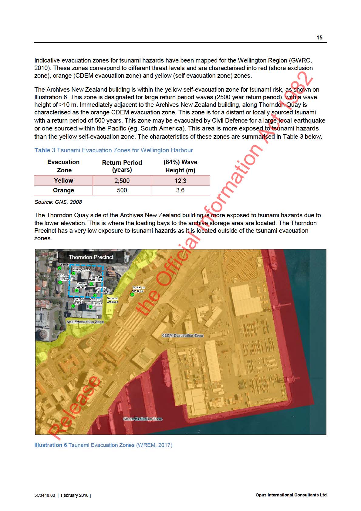
4.5 Tsunami
A tsunami is a natural phenomenon consisting of a series of waves generated when a large volume of water
in the sea or a lake is rapidly displaced. They can affect long stretches of coastline and extend inland for
hundreds of metres to kilometres in low lying areas. The effects of tsunamis can be control ed by the
topography, geomorpholog
Release y, bathymetry, beach slope, coastal orientation, configuration and the
characteristics and direction of arising waves and the built environment within the tsunami run-up zone.
5C3448.00 | February 2018 |
Opus International Consultants Ltd
link to page 19 link to page 19
link to page 20
link to page 20 link to page 22
17
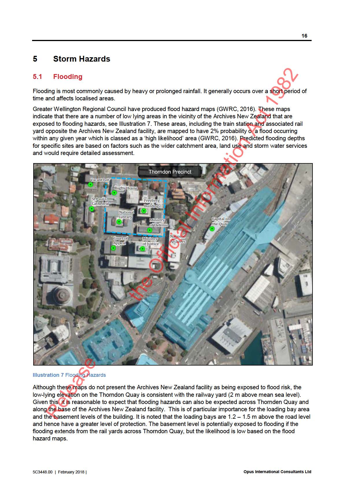
Flooding can inundate buildings, cause foundation damage and contribute to degradation of the building and
its contents. Flood inundation of a building is likely to cause significant damage to stored materials.
The Thorndon Precinct is not shown to be exposed to flooding hazards in the GWRC modelled scenario.
This indicates there is less than a 2% probability of a flood occurring within any given year.
5.2 Storm Surge and Coastal Inundation
Storm surge is a coastal hazard which can induce flooding when storms affect a coastline. Sea level rises as
a result of falling atmospheric pressure and strong winds can push water up against the coast. Coastal
inundation can occur when high tides, storm surge and/or large waves occur at the same time. As storm
surge induces flooding, the likely consequences are described as above in the flooding assessment.
The Thorndon Quay side of the Archives New Zealand facility is on low lying ground which may be exposed
to flooding hazards, as described in Section
5.1 above. However, the facility is 300 m from the existing
Wellington Harbour coastline, with a number of buildings and infrastructure ocated in between. Given this,
the Archives New Zealand is not considered to be exposed to storm surge and coastal inundation hazards.
The Thorndon Precinct is further inland and at a higher elevation than the Archives New Zealand facility and
is also considered to not be exposed to storm surge and coastal inundation hazards.
5.3 Climate Change
The earth’s climate is changing, predominantly due to emissions of greenhouse gases from human activities,
such as burning fossil fuels, agriculture, and deforestation. These greenhouse gases warm the earth and
one of the major and most certain consequences of warming, is sea-level rise (MfE, 2017b). Climate change
and sea-level rise may compound coastal hazards already occurring naturally. The exact nature of the
change has some uncertainty and it is therefore important to understand the range of future potential
scenarios, and the impact they might have, on the existing Archives New Zealand facility and the Thorndon
Precinct.
5.3.1
Sea Level Rise
Hydrological risks such as coastal inundation, coastal erosion or pluvial flooding can be exacerbated by
rising sea level. The nature and frequency of these potentially damaging or disruptive coastal hazards is
likely to increase. With a modest 30 cm rise in sea levels in the next 50 years or so, the current 1%AEP
the Official Information Act 1982
event (a 1 in 100 year event) wil be expected to occur at least once a year in Wellington Harbour
(Parliamentary Commissioner for the Environment, 2015). With a sea-level rise of 50 cm, the current
1%AEP event (a 1 in 100 year event) would occur approximately twice a month (Parliamentary
Commissioner for the Environment, 2015).
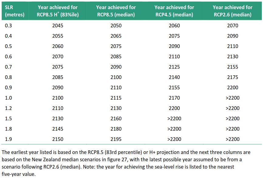
Table 4 shows a range of sea-level rise increments that could be reached in New Zealand and the
approximate timeframe they could be reach for the four scenarios modelled in New Zealand (MfE, 2017a).
The low-emission scenario (RCP2.6) assumes an ‘aggressive emissions’ reduction in the emission fossil
fuels.
The two middle scenarios (RCP4.5 and RCP8.5) should be considered equally in assessments along
with the range between them (MfE, 2017a). The RCP4.5 scenario assumes a reduction in emissions
whereas the RCP8.5 scenario assumes little to no reduction.
The RCP8.5H+ scenario was added to reflect a world where a high rate of rise may be experienced in
the latter part of the century (i.e. faster polar ice sheet melt). This scenario could be used to assess the
adaptability of major infrastructure, and timing of decision points (MfE, 2017a).
Release
5C3448.00 | February 2018 |
Opus International Consultants Ltd
link to page 22 link to page 23 link to page 23
 18
Table 4
18
Table 4 Approximate years when specific sea-level rise increments could be reached for the four scenarios
of sea-level rise in NZ (from MfE, 2017a).
The uncertainty associated wi
th Table 4 is not ‘whether it wil happen’ but rather ‘when wil it happen’ i.e. a
1.5 m sea level rise is predicted to occur in al four pathways, however the predicted year of occurrence
ranges between 2130 for a PRC8.5 scenario and >2200 in a RCP4.5 scenario. Risk management and
planning must therefore recognise there is both a changing risk exposure from coastal storm and erosion
events and also a high level of uncertainly regarding future rates of sea-level rise (MfE, 2017a).
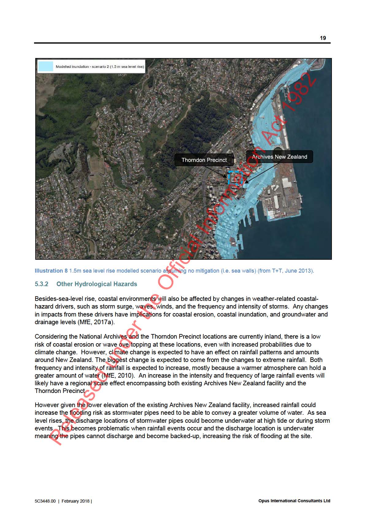
The Thorndon Quay side of the Archives New Zealand facility is on reasonably low lying ground. While the
the Official Information Act 1982
facility is 300 m from the existing Wellington Harbour coastline, with a number of buildings and infrastructure
located in between, a 1.5 m rise in sea levels wil cause this low lying area to be inundated
(Illustration 8)
(T+T, 2013). However, considering the area expected to be inundated is part of Wellington’s business hub, it
is possible that mitigation techniques such as sea walls wil be employed and thus, limit inundation. The
Thorndon Precinct is not model ed to be inundated with a 1.5 m rise in sea levels, however wil have a higher
exposure to storm surge and coastal inundation hazards
(Illustration 8).
Release
5C3448.00 | February 2018 |
Opus International Consultants Ltd
link to page 25
20
6
Anthropogenic Hazards
6.1 Urban Fire
Urban fires can be caused maliciously, by accident, or as the result of an unpredicted ignition (eg. electrical,
mechanical, or chemical fault). Fires can also result from natural causes such as earthquakes or lightning.
Fire can engulf and destroy buildings as well as risking human life. A large fire could significantly damage
stored material at the facility or destroy it completely.
There is a greater level of exposure to urban fire hazards in more highly and densely populated areas. In
such areas, there are generally more sources for fire ignition (land use and building and infrastructure
service pipelines) and fire can more easily spread between closely spaced, flammable buildings - from both
human ignition and following large natural hazard events such as earthquakes or tsunamis.
The central Thorndon area, where the Archives New Zealand and Thorndon Precinct are located, is primarily
occupied by other government and commercial organisations. The surrounding buildings are multi-storeyed
and are likely to be densely populated during business hours, but are likely to be constructed of less
flammable materials.
The Archives New Zealand building is bounded on two sides (east and west) by roads and two sides by
other buildings. Exposure to urban fire hazards is moderated by the presence of Mulgrave Street and
Thorndon Quay along the long axis of the building but the close proximity to the Tramways Building (south)
and Anglican House (north) mean the site is potentially exposed to a significant fire hazard.
By contrast, the Thorndon Precinct area is similarly prone to fire hazards as there are a number of large,
densely populated and closely spaced buildings within the area. These range between commercial premises,
government organisations and residential buildings; a number of which have timber exteriors.
As a result, it is considered that the wider Thorndon area is exposed to fire hazards. The highest levels of
exposure are those in the centre of the precinct area which are bound by multiple buildings, and those
adjacent to timber buildings.
6.2 Petroleum and hazardous substance storage
Substances classed as hazardous may be explosive, flammable, corrosive or toxic. This could include
petroleum or other fuel, gases such as LPG, acids and alkalis, industrial solvents and other chemicals.
Where such substances are stored, the exposure to potential fire, explosion hazards or toxic atmosphere
hazards is heightened. Storage sites can be classed in the following four categories (Opus, 1999):
Major bulk storage tanks (eg. tank farms)
Intermediate bulk storage (eg. service stations and airports)
under the Official Information Act 1982
Small storage sites (eg tanks with capacity less than 40,000 litres)
Pipelines
The nearest known large petroleum storage site to the Archives New Zealand, is the northern end of the
railway yard and the pipelines which connect Kaiwharawhara to Aotea Quay. However, any storage of
petroleum or other hazardous substances at the railway yard is likely to be located north of Westpac
Stadium, away from the train station, which is a significant distance from the Archives facility (>750 m). The
pipelines are located at a greater distance. Given this, the Archives New Zealand is not considered to be
exposed to petroleum storage hazards from these facilities.
Released
There is potential for smaller storage sites to be in a closer proximity to the Archives New Zealand and
Thorndon Precinct area. As aforementioned in Section
6.4, a number of sites have been cited on the
Selected Land Use Register due to the presence of fuel storage tanks, however the presence and function of
5C3448.00 | February 2018 |
Opus International Consultants Ltd
link to page 26
21
these tanks is unknown. The nearest known service station is located approximately ~450 m to the south
and not considered to expose the facility to petroleum hazards.
6.3 Transportation incidents
Transportation incidents are commonly occurring events, particularly along the road network. A
transportation incident has the potential to cause structural damage or induce fire or explosion hazards.
A study of petroleum transportation hazards in the Wellington Region has previously been undertaken
(Opus, 1999) and provides a base to identify the main areas of potential transportation hazards within the
Thorndon area. The study identified Aotea Quay and State Highway 1 as the primary transportation routes in
Thorndon, as well as the NIMT railway. Aotea Quay and State Highway 1 are located approximately 200 m
and 500 m respectively from the Archives New Zealand, indicating that the facility is likely to have a lower
exposure to transportation hazards.
The Archives New Zealand building is bound on two sides by Mulgrave Street and Thorndon Quay.
Thorndon Quay is considered as a secondary route as it links the industrial portion of Thorndon and
Kaiwharawhara to central Wellington and provides an alternative to SH1 to reach Ngauranga and the
northern suburbs. Thorndon Quay carries heavy and industrial vehicles than Mulgrave Street and hence a
higher exposure to transportation incidents which could affect the Archives New Zealand facility. Although
the northern end of Mulgrave Street is an exit from SH1, there are numerous traffic lights which slow traffic
and decrease the likelihood of incidents.
The railway is in the near vicinity to the Thorndon Quay side of the Archives New Zealand. Although rail
incidents are uncommon occurrences, a significant event (such as a train derailment) could expose the
Archives New Zealand building to fire and explosion haza ds.
In addition to Mulgrave Street, the Thorndon Precinct area is also adjacent to Molesworth Street. It is
considered that the exposure to transportation hazards is even lower along Molesworth Street, as it has a
low speed environment and is not a favoured oute for large vehicles to service the surrounding industries.
The Thorndon area is not in the direct flight path for Wellington Airport and hence the hazard from aircraft
incidents is low.
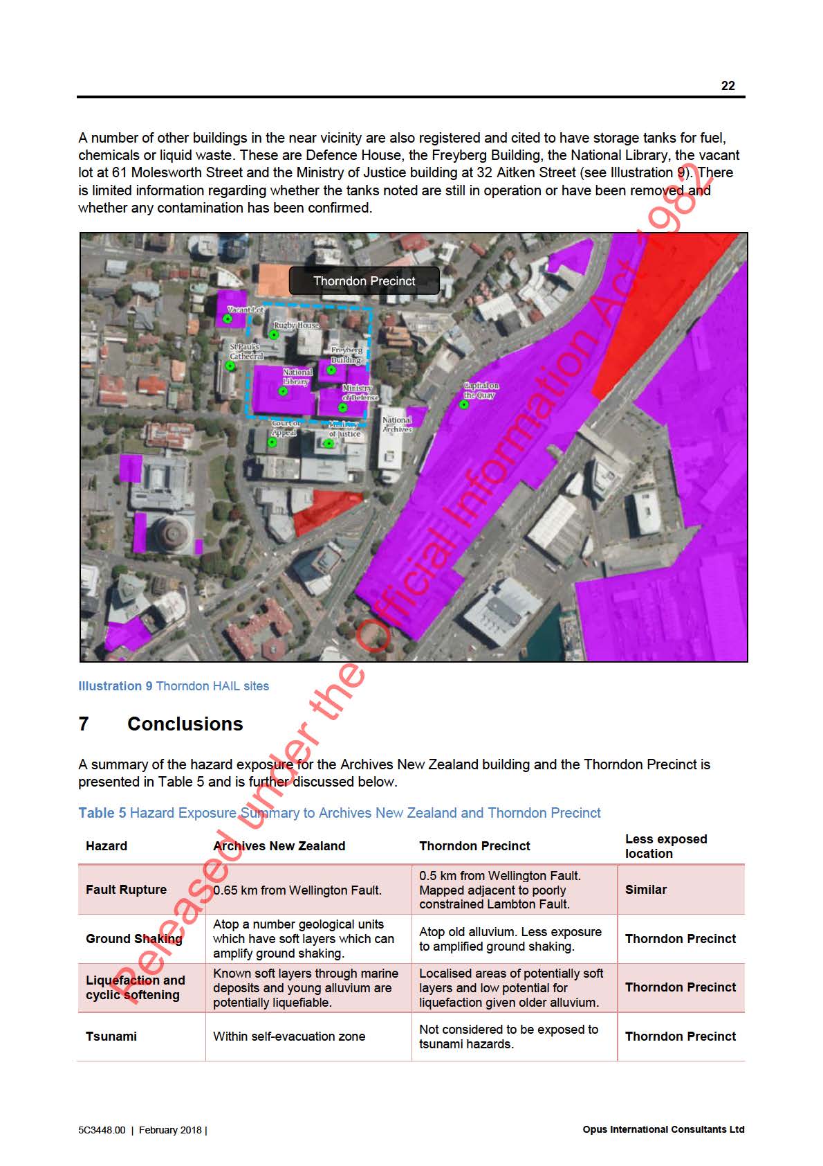
6.4 Contaminated Land
Greater Wellington Regional Council has compiled the Selected Land Use Register of sites that have
accommodated, or currently acc mmodate, activities or industries detailed on the Ministry for the
Environment’s hazardous activities and industries list (HAIL) (MfE 2011). This register indicates that there
are a number of HAIL sites within the vicinity of the Archives New Zealand, see
Illustration 9. Potentially
contaminated land is not likely to adversely affect a building structure but may cause adverse effects to the
under the Official Information Act 1982
environment or human health such as the exposure to contaminated soils or the build of up toxic gas.
It is noted that the Selected Land Use Register lists sites that have a history of hazardous activities or
industries but in many cases, does not detail whether the hazardous activity is applicable to the current land
use, whether contamination is confirmed at the site or whether any remedial works have been undertaken.
The Archives New Zealand facility is registered as a site with a verified history of hazardous activity or
industry, cited to have storage tanks for fuel, chemicals or liquid waste. However, a report was produced in
2009 confirm ng that fuel storage tanks have been removed from the site (MWH, 2009). The report details
soil validation testing following the removal of two fuel storage tanks and identified that a sample retrieved
from the tank site returned che
Released mical concentrations above MfE guidelines. The report detailed that the
contamination was contained within concrete bunding and no significant risks were identified.
5C3448.00 | February 2018 |
Opus International Consultants Ltd
link to page 26 link to page 26
24
The eastern side of the Archives New Zealand adjacent to Thorndon Quay is more exposed to
transportation hazards. This is due to Thorndon Quay is due to Thorndon Quay being considered as a
critical arterial route for Wellington City and is therefore likely to have a higher volume of traffic and as it
is also adjacent to the railway yard and train station, where it is exposed to potential rail incidents.
There are a number of sites within the wider Thorndon area which have potentially contaminated land.
The Archives New Zealand is listed as a HAIL site due as fuel storage tanks were previously stored on
the site.
8
References
Brabhaharan, P (1994). Assessment and mapping of earthquake induced liquefaction hazards in the
Wellington Region, New Zealand. The first ANZ Young Geotechnical Professionals Conference,
February 9-12, 1994, Sydney, Australia.
Bradley, B.A., Wotherspoon, L. M., Kaiser, A. E. (2017). Ground motion and site effect observations in the
Wellington region from the 2016 Mw7.8 Kaikoura, New Zealand earthquake. Bulletin of the New
Zealand Society for Earthquake Engineering 50(2) 94-105
Cubrinovski, M., Bray, J. D., de la Torre, C., Olsen, M. J., Bradley, B. A., Chiaro, G., Stocks, E.,
Wotherspoon, L. (2017). Liquefaction effects and associated damages observed at the Wellington
CentrePort from the 2016 Kaikoura earthquake. Bulletin of the New Zealand Society for Earthquake
Engineering 50(2) 152-173
Cubrinovski, M., Ishihara, K. (2003). Liquefaction-induced ground deformation and damage to piles in the
1995 Kobe earthquake. Paper presented at the International Conference Skopje Earthquake 40 Years
of European Earthquake Engineering, Skopje Ohrid, Macedonia.
GeoNet (2016). Strong Motion Data. Retrieved July 2017 from
https://www.geonet.org.nz/data/types/strong motion
GNS Science (2009). Tsunami evacuation zones for Wellington and Horizons regions defined by a GIS-
calculated attenuation rule, GNS Science Report 2008/30. Prepared by Leonard, G.S.; Power, W.;
Lukovic, B.; Smith, W.; Johnston, D. and Downes, G.
Greater Wellington Regional Council (2016). Flood Hazard Areas. Retrieved July 2017 from
http://mapping.gw.govt.nz/GW/Floods/Information/GW%20Flood%20Areas%20Information.htm
Institute of Geological and Nuclear Sciences (1996). Geology of the Wellington area, scale 1:50,000. Institute
of Geological & Nuclear Sciences 1:50,000 geological map 22. Lower Hutt, New Zealand. Compiled by
under the Official Information Act 1982
Begg, J.G. and Mazengarb, C.
Institute of Geological and Nuclear Sciences (2000). Geology of the Wellington area, scale 1:250,000.
Institute of Geological and Nuclear Sciences 1:250 000 geological map 10. Lower Hutt, New Zealand.
Compiled by Begg, J.G and Johnston, M.R.
Ministry for the Environment (MfE) (2010). Tools for estimating the effects of climate change on flood flow: A
guidance manual for local government in New Zealand. Ministry for the Environment, Wellington, New
Zealand.
Released
Ministry for the Environment (MfE) (2011). Hazardous Activities and Industries List. Ministry for the
Environment, Wellington, New Zealand.
5C3448.00 | February 2018 |
Opus International Consultants Ltd
25
Ministry for the Environment (MfE) (2017a). Coastal hazards and climate change: Guidance for local
government. Ministry for the Environment, Wellington, New Zealand.
Ministry for the Environment (MfE) (2017b). Preparing for coastal change: A summary of coastal hazards and
climate change guidance for local government. Ministry for the Environment, Wellington New Zealand.
Ministry of Works (1961). Bore logs and test results from bores on site of proposed new office for
Government Printer, Thorndon Quay – Mulgrave Street.
Murashev and Palmer, 1998. Geotechnical issues associated with development on Wellington’s waterfront.
IPENZ Transactions, Vol. 25, No. 1/CE, 1998
MWH (2009). Replacement Standby Generator: Tank removal soil validation. Prepared for Archives New
Zealand by Dal y, V.
New Zealand Department of Scientific and Industrial Research (1974). Microzoning for earthquake effects in
Wellington, New Zeland. Part Sheet N 164. Bul etin 213. Prepared by Taylor, G.T., Adams, R.D.,
Hatherton, TT. Milne, J.D.G., Northey, R.D. and Stephenson, W.R.
Opus International Consultants (1999). Petroleum Transportation Hazards in the Wellington Region.
Prepared for the Wellington Regional Council. GER 1999 1, 5C2802.00.
Parliamentary Commissioner for the Environment (2015). Preparing New Zealand for rising seas: Certainty
and Uncertainty.
Power, W.L. (2013). Review of Tsunami Hazard in New Zea and (2013 Update). GNS Consultancy Report
2013/131. 222 p.
Semmens, S. (2010). An engineering geological nvestigation of the seismic subsoil classes in the central
Wellington commercial area. Unpublished thesis, University of Canterbury, Christchurch, New
Zealand.
Sinclair, M. (2002). Meteorological Research: How often is New Zealand hit by tropical cyclones? Water and
Atmosphere 10 (1).
Stirling, M., McVerry, G., Gerstenberger, M., Litchfield, N., Van Dissen, R., Berryman, K., Barnes, P.,
the Official Information Act 1982
Wallace, L., Vil amor, P., Langridge, R., Lamarche, G., Nodder, S., Reyners, M., Bradley, B., Rhoades,
D., Smith, W., Nicol, A., Pettinga, J., Clark, K., Jacobs, K. (2012). National seismic hazard model for
New Zealand: 2010 Update. Bul etin of the Seismological Society of America 102: 1514-1542.
Tonkin and Taylor (1994). Capital Gateway Development Investigation. Report prepared for Zeta
Investments Ltd.
Tonkin and Taylor (2013). Sea level rise options analysis. Report prepared for Wellington City Council.
Wellington City Council (no date). WebMap. Retrieved July 2017 from
http://wel ington.govt.nz/webmap/wccmap.html#
Wellington Region Emergency Management WREM (2017). Tsunami evacuation zone maps. Retrieved July
2017 from http://www.getprepared.org.nz/tz
Release
5C3448.00 | February 2018 |
Opus International Consultants Ltd
the Official Information Act 1982
Figures
Release
5C3448.00 | February 2018
the Official Information Act 1982
Opus International Consultants Ltd
L10, Majestic Centre, 100 Willis St
PO Box 12 003, Wellington 6144
New Zealand
t: +64 4 471 7000
f: +64 4 471 1397
w: www.opus.co.nz
Release