

ACT
Decision Document
Location Information
15 June 2017
INFORMATION
RELEASED UNDER
THE OFFICIAL
link to page 3 link to page 4 link to page 5 link to page 5 link to page 5 link to page 6 link to page 7 link to page 7 link to page 8 link to page 8 link to page 9 link to page 9 link to page 10 link to page 10 link to page 10 link to page 10 link to page 10 link to page 11 link to page 11 link to page 13 link to page 13
 Contents
1
Introduction .............................................................................. 3
2
Guiding Principles ..................................................................... 4
3
Overview of Decisions ............................................................... 5
3.1
Confirmed Functional Structure ...................................................... 5
3.1.1
New LI Functional Structure chart .................................................. 5
3.1.2
Final decisions - tabled summary ................................................... 6
3.2
Confirmed Functions and Responsibilities ........................................ 7
3.2.1
Sector Data Programmes (SDP) ..................................................... 7
3.2.2
Geodesy and Geospatial Development ............................................ 8
ACT
3.2.3
Data Services .............................................................................. 8
3.2.4
Integrated Property Services (IPS) and Addressing Programme ......... 9
3.2.5
Topography ................................................................................. 9
3.2.6
Hydrography ............................................................................. 10
3.2.7
Business Management ................................................................ 10
3.2.8
Business Innovation Group (BIG) ................................................. 10
3.3
Strategic Responsibilities ............................................................ 10
3.3.1
LILT Strategic Responsibilities ..................................................... 10
UNDER
4
Feedback ................................................................................. 11
4.1
Summary of feedback ................................................................. 11
5
Next steps ............................................................................... 13
5.1
Support for Staff ........................................................................ 13
INFORMATION
Contents
1
Introduction .............................................................................. 3
2
Guiding Principles ..................................................................... 4
3
Overview of Decisions ............................................................... 5
3.1
Confirmed Functional Structure ...................................................... 5
3.1.1
New LI Functional Structure chart .................................................. 5
3.1.2
Final decisions - tabled summary ................................................... 6
3.2
Confirmed Functions and Responsibilities ........................................ 7
3.2.1
Sector Data Programmes (SDP) ..................................................... 7
3.2.2
Geodesy and Geospatial Development ............................................ 8
ACT
3.2.3
Data Services .............................................................................. 8
3.2.4
Integrated Property Services (IPS) and Addressing Programme ......... 9
3.2.5
Topography ................................................................................. 9
3.2.6
Hydrography ............................................................................. 10
3.2.7
Business Management ................................................................ 10
3.2.8
Business Innovation Group (BIG) ................................................. 10
3.3
Strategic Responsibilities ............................................................ 10
3.3.1
LILT Strategic Responsibilities ..................................................... 10
UNDER
4
Feedback ................................................................................. 11
4.1
Summary of feedback ................................................................. 11
5
Next steps ............................................................................... 13
5.1
Support for Staff ........................................................................ 13
INFORMATION
RELEASED
OFFICIAL
THE
Report Title | Objective ID
Business Group Name | Land Information New Zealand © Crown Copyright | 15 June 2017 | 2
 1
Introduction
1
Introduction
Kia ora koutou
Thank you to everyone who has provided feedback. I have appreciated the open and honest
conversations I have had and the feedback I have received of both support and suggested
changes to the proposal.
I know many of you have taken the time to consider the impacts of the change and have
shared these with me. I hugely appreciate that you have considered the change from a wide
perspective, taking into account the opportunities and the risks from both an internal and
external perspective.
ACT
I understand fully the personal impact of these changes and appreciate the positive approach
everyone has taken during this process.
As I have shared with you previously, I see this as the continuation of an evolution for Location
Information, in terms of how we work together, and across the systems we lead and influence.
Being an agile and flexible high performing organisation means that we can shift our resources
and focus our efforts where we can make the biggest difference.
UNDER
I would like to reiterate that this high level change is a first step. The Location Information
Group Managers will be thinking further about how we can best organise each of the teams in
the group to help LINZ make the step change that is required of us for New Zealand, and New
Zealanders.
I believe that the functional structure outlined in this document will set us up to have the right
conversations about what we need in place to achieve ‘The Power of Where’.
INFORMATION
It’s an exciting time for Location Information, and I appreciate your continued honesty and
commitment. It is also a time of ambiguity as we turn our focus to the next phase. I
appreciate change isn’t easy and I will continue to ensure this is managed in a way that
provides everyone with certainty as quickly as possible.
RELEASED
Thank you again for your involvement. Please do continue to support each other, and make
use of the assistance available to you.
Please talk to your manager or myself directly if you have any questions.
OFFICIAL
Jan Pierce
Deputy Chief Executive
Location Information
THE
Land Information New Zealand
3
 2 Guiding Principles
Location Information’s (LI) direction and structure reflect LINZ’s core principles for creating a
high performing organisation. These are:
Keep it simple – be clear on what we want to achieve and why we are doing it
Keep engaged – keep our people and stakeholders engaged and connected at the right time
Agility – strengthen our resilience and capability to be agile and work positively in our
changing environment and context
Pace and urgency matter – it is vital that due consideration goes into any actions that result
and that we implement any change with pace and urgency so that our people have clarity
and certainty
ACT
The following design principles were also used to underpin this change specifically for Location
Information, to enable:
The biggest positive impact for LINZ’s customers and stakeholders (towards the tenfold
increase)
The best utilisation of the capability and resources across LI
UNDER
The best way to focus our efforts
Clear roles and responsibilities
Minimal key person risk and provide for succession planning
INFORMATION
RELEASED
OFFICIAL
THE
Land Information New Zealand
4

 3
Overview of Decisions
3.1 Confirmed Functional Structure
3
Overview of Decisions
3.1 Confirmed Functional Structure
A number of written and verbal feedback submissions were received.
We received a lot of positive feedback to all aspects of the proposal. These included support for
the proposed functional structure and the integration of the geospatial strategy principles
across LI to shape our work.
Some concerns were raised about the Addressing team (who are currently part of the
Topography and Addressing team) becoming part of the IPS and Addressing team and the
impacts of the disestablishment of the NZ Geospatial Office.
The written feedback submissions and responses to these are summarised on pages 11-13.
ACT
As an outcome of feedback and the guiding and design principles above, the proposed LI
functional structure as outlined in the consultation document is confirmed:
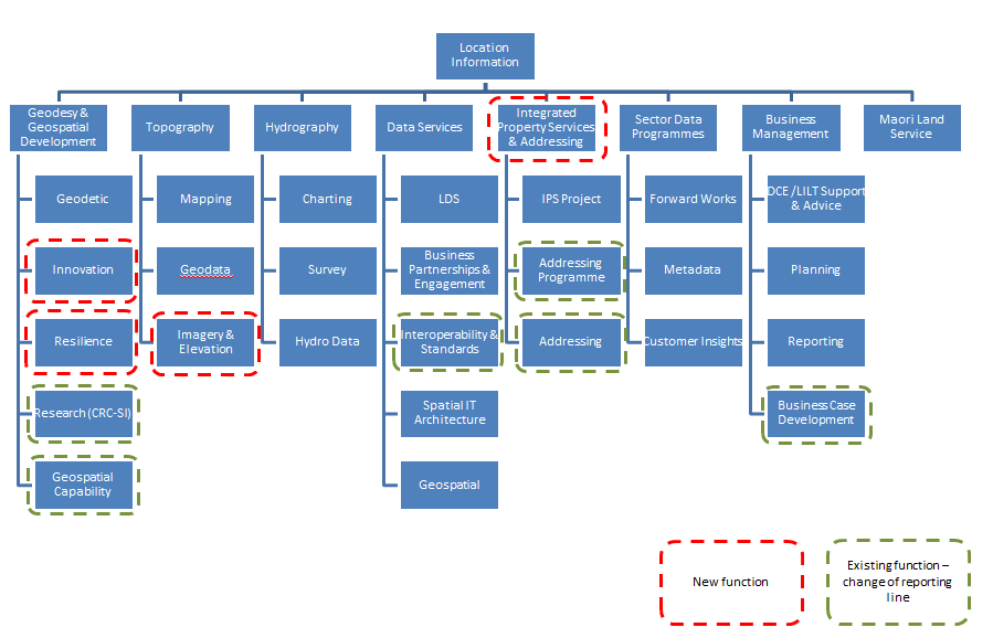
3.1.1 New LI Functional Structure chart
UNDER
INFORMATION
RELEASED
OFFICIAL
THE
Land Information New Zealand
5

3.1.2 Final decisions - tabled summary
The following table summarises the proposed changes and the final decisions. The decisions
are then explained in more detail below the table.
Proposal
Decision
When
Disestablishment of the Group
This has been confirmed
Effective immediately
Manager Topography and
Addressing position
Disestablishment of the Group
This has been confirmed
Refer to page 8. Timing to
Manager Sector Data
be agreed.
Programmes (SDP) position
Disestablishment of the Manager
This has been confirmed
Effective immediately
Location Data position
Disestablishment of the Chief
This has been confirmed
Refer to page 7. Timing to
ACT
Steward National SDI position
be agreed.
Establishment of the Group
This has been confirmed
Effective immediately
Manager Integrated Property
Services and Addressing position
Establishment of Group Manager
This has been confirmed
Effective immediately
Topography position
Establishment of Manager
This has been confirmed
Refer to page 8. Timing to
UNDER
Resilience position
be agreed.
Change of reporting line for Team This has been confirmed
Refer to page 9. Timing to
Manager Addressing and Electoral
be agreed.
Advisor from Group Manager
Topography and Addressing to
Group Manager Integrated
Property Services and Addressing
INFORMATION
Change of reporting line for
This has been confirmed
Refer to page 9. Timing to
Senior Technical Leader (BIG)
be agreed.
from Chief Geodesist to Group
Manager Topography
RELEASED
Change of reporting line for
This has been confirmed
Refer to page 9. Timing to
Senior Technical Business Advisor
be agreed.
(BIG) from Chief Geodesist to
Group Manager Integrated
Property Services and Addressing
OFFICIAL
Change of reporting line for
This has been confirmed
Effective immediately
Senior Technical Business Advisor
(BIG) from Chief Geodesist to
Business Manager
THE
Business Management widens its
This has been confirmed
Effective immediately
remit to include business case
development. An addition of one
direct report for the Business
Manager position. Senior
Technical Business Advisor
reports to Business Manager.
Land Information New Zealand
6
 Proposal
Decision
When
Proposal
Decision
When
Change of reporting line for
This has been confirmed
Refer to page 8. Timing to
Technical Leader (BIG) from
be agreed.
Chief Geodesist to Manager
Resilience
Change of reporting line for SDI
This has been confirmed
Effective immediately
Technical Leader (3 positions).
One position changes reporting
line from Chief Steward National
SDI to Group Manager IPS and
Addressing
The remaining two positions
This has been confirmed
Refer to page 9. Timing to
change reporting line from Chief
be agreed.
Steward National SDI to Group
Manager Data Services
ACT
The SDI Engagement Leader
This has been confirmed
Refer to page 8. Timing to
position becomes open-term.
be agreed.
Change of reporting line from
Chief Steward National SDI to
Group Manager Data Services
Change of reporting line for
This has been confirmed
Effective immediately
Director CRC-SI from Group
UNDER
Manager SDP to Chief Geodesist
Change of reporting line for
This has been confirmed
Effective immediately
Principal Analyst from Group
Manager SDP to Chief Geodesist
3.2 Confirmed Functions and Responsibilities
INFORMATION
3.2.1 Sector Data Programmes (SDP)
To ensure the geospatial strategy principles are fully integrated into LI’s work,
functionality which currently falls under the SDI umbrella will be focused across LI to
RELEASED
provide the most value, and also align to LINZ’s strategic objectives. SDP work
programmes are nearing completion and the Customer Insights team which is currently
part of SDP will move to the Strategy and Stewardship business group in the near
future. As a consequence, the Sector Data Programmes team is disestablished as a
separate entity, however this will take time as we work through the transition of SDP
OFFICIAL
programmes.
As LI reprioritises its work programme to align with LINZ’s strategic objectives there is
no longer a need for a single point of leadership for SDI. The focus of the leadership
needs to be where it can provide the most value plus the geospatial strategy principles
will be integrated across LI. Therefore, the role of Chief Steward National SDI is
THE
disestablished. However, the Geospatial Office has a current work programme in place
that needs to be considered as part of the transition to the new functional structure.
This will occur over the coming months and will include a detailed communications plan
with customers and stakeholders.
Land Information New Zealand
7

As there are programmes to be completed, the Group Manager Sector Programmes
position, while disestablished, is retained until an agreed date is confirmed.
Consequently, the Customer Insights team will continue to report to the Group Manager
Sector Data Programmes. This will also provide the opportunity for the DCE Strategy
and Stewardship to review requirements for her business group, including the
assessment of needs in relation to a customer insights function.
3.2.2 Geodesy and Geospatial Development
The Geodesy and BIG team becomes the Geodesy and Geospatial Development team to
enhance the system leadership of positioning and innovative thinking in the geospatial
area and reflect the new functions of, Innovation and Resilience, and the incorporation
of the Research (CRC-SI) and Geospatial Capability functions from SDP.
Innovation will focus on new technologies, testing the things we do now and our plans
for the future. Technology is moving fast and we need to be attuned to this change and
look for the best opportunities. This function will have an across LI view.
ACT
Resilience is one of LINZ’s organisational strategic objectives. The aim of this function is
to continue scoping the resilience work, identifying opportunities and working closely
with stakeholders. The focus of this work is on the four R’s - Research, Response,
Recovery and Reduction and have an across LI view. Consequently, a new position,
Manager Resilience, is established, to drive this work. Further work to determine how
this function operates needs to occur. The Chief Geodesist will have oversight of this.
The Technical Leader position (BIG) which currently has a focus on resilience will
change reporting line from Chief Geodesist to Manager Resilience. As outlined above,
UNDER
further work needs to be completed to determine how best this function will operate.
This reporting line won’t change until this work has occurred.
The Research function needs to be closely aligned with the Innovation function, so it
transfers from Sector Data Programmes to become part of the Geodesy and Geospatial
Development team. For similar reasons, the Geospatial Capability function will also
become part of the Geodesy and Geospatial Development team to enable working
INFORMATION
closely and alignment with both the Research and Innovation functions. Both roles,
within these functions, Director CRC-SI and Principal Analyst, change reporting line
from Group Manager SDP to Chief Geodesist. This is effective immediately.
3.2.3 Data Services
RELEASED
Data Services will enhance our system understanding of data customers, connecting
with industry and supporting others to use geospatial information internally and
publishing LINZ and other’s geospatial data. It will expand its remit focusing on a wider
delivery of data across the system and spatial industry.
OFFICIAL
To reflect the above changes, the functions of Business Partnerships, currently with
Data Services, and Engagement within Sector Data Programmes will be combined
within Data Services. As a result, the SDI Engagement Leader position becomes open
term and will change reporting line from Chief Steward National SDI to Group Manager
Data Services. Further work to determine how these functions operate is required as
THE
Data Services takes on this wider remit of work. This will be completed by the Group
Manager in the next period to ensure a smooth transition. This reporting line won’t
change until this work has occurred.
Business Partnerships and Engagement will focus on opportunities for LI by looking at
the experience of our customers - bringing the users voice to the work we do,
cultivating how we can better work together. It will aim to provide a consultancy service
between government agencies that have a geospatial need.
Land Information New Zealand
8

With Data Services widening its remit of work, the Interoperability and Standards
function will be incorporated from the SDP team into Data Services. Two SDI Technical
Leader positions will change reporting line from Chief Steward National SDI to Group
Manager Data Services. As mentioned above, further work to determine how these
functions operate is required and this will occur over the next period. This reporting line
won’t change until this work has occurred.
As Data Services expands its remit of work, consideration will also need to be given to
the Geospatial Office’s current work programme as part of the transition to the new
functional structure. This will take time to work through.
3.2.4 Integrated Property Services (IPS) and Addressing
Programme
To enhance our contribution to the property system, the Integrated Property Services
(IPS) and Addressing Programme is confirmed as a permanent team to reflect LINZ’s
commitment to enabling decisions around property and land use be informed by
ACT
quality, easily accessible and linked property information.
There is a natural fit for work relating to Integrated Property Services and Addressing to
be undertaken within the team to make use of capability and to minimise duplication of
effort. As a consequence, there will be a change of reporting line for the Team Manager
Addressing and Electoral Advisor from Group Manager Topography and Addressing to
Group Manager Integrated Property Services and Addressing. However we will need to
work through the structure for both the IPS and Addressing team, and the Topography
team and therefore the reporting line won’t change until this is complete.
UNDER
There is also a change of reporting line for one of the Senior Technical Business Advisor
(BIG) positions from Chief Geodesist to Group Manager Integrated Property Services
and Addressing, as the BIG positions move to new functions across LI. Again this
reporting line change won’t occur until the structure of the IPS and Addressing team is
complete.
One of the SDI Technical Leader positions currently on secondment in IPS and
INFORMATION
Addressing changes reporting line from Chief Steward National SDI to Group Manager
IPS and Addressing. This is effective immediately.
3.2.5 Topography
RELEASED
To provide a wider focus for our Mapping team, Mapping 2025 will seamlessly map New
Zealand, from Aoraki/Mt Cook to the Continental Shelf, to contribute to New Zealand’s
economic, social and cultural prosperity.
After receiving verbal feedback on the Remote Sensing function, a decision has been
made to rename it to Imagery and Elevation, which better reflects the function. It will
OFFICIAL
bring together Imagery, historic imagery and lidar into one function. The coordination
of imagery is similar to lidar, and has similar stakeholders.
As a result, there will be a change in reporting line for the Senior Technical Leader
position (BIG) from Chief Geodesist to Group Manager Topography. However there
THE
needs to be an assessment of the requirements for this area which will happen over the
next few months. Consequently, this reporting line change will occur after this.
As a consequence of the above, and with Addressing moving to the IPS and Addressing
team, the positions of Group Manager Topography and Addressing, and Manager
Location Data are disestablished. A new position, Group Manager Topography is
established to provide a system approach to our mapping.
Land Information New Zealand
9

3.2.6 Hydrography
There are no changes to Hydrography. The team is currently recruiting a Manager
Marine Geospatial Data and Products, which is a re-definition of the currently vacant
Manager Chart Production position to make it more fit for purpose for future needs.
3.2.7 Business Management
The work of Business Management is expanded to include business case development
for LI as well as planning, reporting and providing advice and support to DCE and LILT.
To enable focus for LI on customers and stakeholders, the Business Management team
will provide a coordination role. This function will also provide a closer connection with
Corporate.
As a consequence, there is a change in reporting line for one of the Senior Technical
Business Advisor (BIG) positions from Chief Geodesist to Business Manager. The
Business Manager position changes, to include one direct report.
ACT
3.2.8 Business Innovation Group (BIG)
The BIG positions move to the new functions of Addressing, Business Management,
Imagery & Elevation, and Resilience, as outlined above, rather then providing support
from a central team. Consequently, the BIG team will be disestablished as an entity.
Over the next few months we will need to work through where the BIG programmes of
work best fit across LI. Consequently changes in reporting line for all positions (apart
from the Senior Technical Business Advisor position which reports to the Business
UNDER
Manager, effective immediately) will occur after this happens.
3.3 Strategic Responsibilities
3.3.1 LILT Strategic Responsibilities
INFORMATION
To enable LI to help LINZ make the step change required as a system leader means
influencing and connecting across the sectors, and being deliberate in the way we work with
our partners, so that we can create the right conversations and opportunities, and to leverage
the expertise and knowledge of others to help achieve our wider goals.
RELEASED
Given the changing demands of our customers and advancing technologies as well as our
limited capacity it’s critical our efforts are focused on making the biggest difference. We must
also ensure we are more joined up in the property and location systems and leverage collective
resources across these systems.
OFFICIAL
To action this, the Location Information Leadership Team (LILT) will take responsibility for our
strategic work. This is to highlight the importance of this work and to emphasise an across
system approach. Each Group Manager will have a primary focus of supporting each of the
strategic projects and a secondary responsibility for the geospatial strategy principles and
customer and stakeholder relationships.
THE
In addition to the above, there will be an on-going process that will require prioritisation at
both a strategic and operational level. This will be a role for the LI Leadership Team and will
require input from across the group. With LI’s large work programme there’s a need to ensure
we are working on the right things at the right time, prioritising work appropriately.
Land Information New Zealand
10

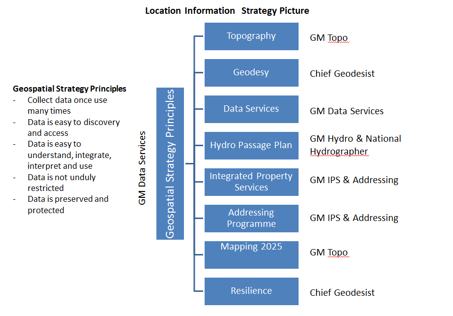
LILT’s strategic responsibilities are outlined in the LI Strategy Picture below:
ACT
UNDER
4
Feedback
4.1 Summary of feedback
Below is a summary of written feedback submissions received and responses.
INFORMATION
Subject
Feedback (summarised) Response
Impact of the proposal to
Concern expressed about
These comments identify
transfer the Addressing team
decoupling the Addressing
issues with both, across LI
from Topography and
team from its support
support and prioritisation at
RELEASED
Addressing, to be part of the
network within the
an operational and strategic
IPS and Addressing team
Topography and
level. This is an area that LILT
Addressing team
needs to address to ensure
A concern the Addressing
the right support and
team will have to bring in
prioritisation is occurring on
skills to replace those that
an on-going basis.
OFFICIAL
they currently access
Geospatial strategy principles Strong support for
Agreed
integrating the Geospatial
strategy principles
THE
It is unclear how we carry
This will need to be
out our external location
considered by the GM Data
system leadership role to
Services who has the primary
encourage other
strategic responsibility for the
organisations to work to
geospatial strategy principles,
the geospatial strategy
with support from the rest of
principles
the LILT.
Land Information New Zealand
11
 Subject
Feedback (summarised) Response
Subject
Feedback (summarised) Response
Disestablishment of the NZ
How do we manage and
We will need to ensure that a
Geospatial Office (NZGO)
maintain the strong
detailed communication plan
relationships developed
is developed to ensure that
through NZGO?
stakeholders understand the
Stakeholders may express
changes and are kept abreast
concern to the Minister
of developments.
Disestablishment of the SDI
There needs to be in place
Leadership role
some mechanism that
ensures that the concept of
the national SDI, and its
role in supporting a “world
This will need to be
class Location System” is
considered as part of the
not lost
planning for implementation
of the functional structure,
Linz has performance
measures in place on the
along with the detailed
ACT
high reuse value
implementation of each team
fundamental datasets
structure.
which will need to be
reviewed
Increasing the use of
A recommendation to
The Strategy & Stewardship
geographic information
target where geospatial
Group are doing the work to
awareness is lowest, so we get a clear view of the tenfold
can have the greatest
goal. There will be
UNDER
impact on our tenfold goal, opportunity for input to this
and also our customer’s
work, which will then support
goals.
the direction for our efforts.
Geospatial capability
With geospatial capability
This will be an on-going
being built across LI how
process that will require
will you ensure alignment? prioritisation at both a
strategic and operational
INFORMATION
level. This will be a role for
the LI Leadership Team and
the People and Technical
Leaders in LI. We will create
mechanisms that ensure
RELEASED
planning is an active process.
SDI Engagement Leader
A suggestion to change the This can be considered by the
name of SDI Engagement
GM Data Services when
Leader to something more
determining how the
comprehensible such as
functions will operate
OFFICIAL
Geospatial Engagement &
Community Advocate
Customers
One person thought there
The requirements for
is a disconnect with Data
information about our
Services’ work with
customers will need to be
THE
customers, and the work
considered as part of the next
Customer Insights is doing. phase of the structure.
Land Information New Zealand
12
 Subject
Feedback (summarised) Response
Subject
Feedback (summarised) Response
Remote Sensing renamed
Support for this function
Agreed
Imagery and Elevation
Under this new function,
Group Managers will assess
are there any
the requirements for the
responsibilities pertaining
detailed function and
to bathymetric lidar?
structure in their teams
5 Next steps
Location Information requires a structure that will enable us to focus and align our efforts to
deliver LINZ’s strategic objectives, enable the Group to work in a more connected way, and
maximise LI’s capacity and resources.
ACT
The new LI functional structure is at a high level. Some positions will be confirmed
immediately, others will move as we work through transitioning to the new functions and part
of specific implementation in each team. Work on this transition will occur over the next few
months and will require input and involvement from right across LI.
Where necessary, a detailed communication plan will also be developed for our customers and
stakeholders to keep them informed of changes within the Group.
UNDER
5.1 Support for Staff
It is acknowledged that change can be unsettling. If you have any professional or personal
concerns that arise as a result of this process, you are welcome to discuss them with Jan
Pierce, DCE, or Lyndsey Gilbert in HR.
INFORMATION
If you believe you would benefit from independent confidential support you are reminded that
the Employee Assistance Programme (Vitae) is available to you at any time for confidential
counselling or other assistance.
Their contact details are:
RELEASED
Phone – 0508 664 981
Email –
[email address]
If you need any further clarity, you are welcome to speak to Lyndsey Gilbert in HR.
OFFICIAL
THE
Land Information New Zealand
13