FEEDBACK DOCUMENT
7 AUGUST 2018
ACT
GEOSPATIAL FORM AND FUNCTION REVIEW
STANDARDS AND INTEROPERABILITY REVIEW
UNDER
INFORMATION
RELEASED
OFFICIAL
THE
1
Feedback on Geospatial role and function reviews –
Overview
1. Background and Context
Geospatial data is critical to NZ’s prosperity and resilience. It is key to a modern digital economy- and to
effective public services.
LINZ is the Government leader in geospatial. In 2007, we launched the Geospatial Strategy to improve
coordination, sharing and use of geospatial data across government. The Strategy had four goals – good
governance across the system; creating and maintaining key geospatial datasets; accessible and useable
Government geospatial data; and interoperability.
In the 10 years since we launched the Geospatial Strategy, LINZ has:
ACT
Adopted a “data first” and “digital by default” business strategy.
Developed the LINZ Data Service, establishing data as a stand alone product and working with
customers to develop new, high value datasets. LINZ has recently established a syndicated contract
that allows other agencies to establish the same data publishing capability at a much lower cost.
Been involved nationally and internationally in creating data standards – across hydrography,
addressing, imagery and elevation
UNDER
Collected and maintained key geospatial datasets (such as aerial photography and elevation data) to
improve NZ’s economy, resilience, environment and infrastructure development through the
Mapping 2025 project
Worked on the property system to ensure quality, accessible, linked property data – IPS, Addressing,
MLS, ASaTS
INFORMATION
Been involved in research, capability building and awareness raising across Government
While the goals and principles of the Geospatial Strategy still hold true, a lot has changed since it was first
introduced:
RELEASED
LINZ’s Outcomes Framework has set clear priorities for LINZ to achieve in the next five years to ensure
that high-value geographic and property data are used effectively to deliver value for New Zealand.
This sets a clear direction for LINZ’s work in geospatial and encompasses the aims of the Geospatial
Strategy.
OFFICIAL
In 2017, the New Zealand Geospatial Office was disestablished and its functions distributed across LI;
and the principles of the Geospatial Strategy were integrated into the LI strategy.
There is now stronger data and ICT leadership across government.
The Stats NZ CE has taken on the
role of Chief Data Steward; and the Chief Executive at the Department of Internal Affairs (DIA) is the
THE
Chief Digital Officer, responsible for delivering the Government ICT strategy.
Both Statistics NZ and DIA are working to ensure that data and information held by Government can
be used to inform policy and add public and private value, with a focus on standards to enable sharing
of data; building capability; and working across Government to ensure key data sets are accessible.
This includes Stats NZ setting up a cross-Government Approvals Board to review data collection
standards and recommend whether they should be published for use across Government; and
2
proposals to strengthen the Government Chief Data Steward’s leadership role to set mandatory
standards and direct the adoption of common data capabilities to enable a common approach to the
collective management and use of data.
Given these changes – and changing (and increasing) customer demands, advancing technologies and our
limited capacity – it is even more critical that we focus on how we can have the most impact. To achieve LINZ’s
outcomes, we need a more focused, collective LI work programme and stronger leadership and engagement
across the geospatial system.
To understand how LI can best respond to these challenges, work was commissioned to inform LILT’s thinking
about the current roles, responsibilities and functions in LI – and what will be required in future to support
LINZ’s strategic direction:
A review of LINZ’s Geospatial role and function to ensure alignment with the Outcomes Framework
A review of our Geospatial Standards and Interoperability work
Teams and individuals across LI, as well as external stakeholders, were consulted widely in completing this
ACT
work.
We are now seeking your feedback on the findings and recommendations of these reports before making
decisions about next steps.
2. Providing Feedback
Feedback should be provided in writing to [email address].
UNDER
Both individual and group feedback is welcome. Feedback closes at
5pm on Friday 17 August. If you have any
questions about the process or the review documents, please talk to your manager.
In your feedback on these reports, we’d like you to answer the following questions:
Geographic role and function review
INFORMATION
Do you think that the approaches to system leadership, stakeholder engagement and capability
building recommended in this report will help LI to:
o Increase LINZ’s impact and influence?
o Achieve LINZ Outcomes?
RELEASED
Geospatial Standards and Interoperability review
Do you think the changes to the S&I function outlined in this document will help LI to:
o Achieve LINZ Outcomes?
o Develop and promote geospatial standards and interoperability within LINZ and across the
OFFICIAL
system?
3. Next steps
Your feedback will be collated and considered by LILT and the key themes will be shared with staff.
THE
Once your feedback has been considered, LILT will release a proposal for changes to the current S&I functions
for consultation.
LILT is also reviewing stakeholder engagement, awareness raising and capability building activities across LI,
starting with LILT’s strategic engagement activities. Your feedback on the attached reviews will also help to
inform this work.
3
ACT
Review of LINZ’s geographic data role and functions
Prepared by Deidre Hill
UNDER
March 2018
INFORMATION
RELEASED
OFFICIAL
THE
4
1. Introduction
This document outlines the findings of a review of LINZ’s geographic role and function. The review
covers the work of the Location Information Group (LI), including the capability transferred in from
the New Zealand Geospatial Office (NZGO).
This document makes recommendation on LINZ’s geospatial functions but does not cover LI’s
operating model or organisational structure.
The report is divided into two sections:
General findings from the review
Answers to some specific questions posed by the Location Information Leadership Team to
inform their thinking
ACT
2. Background
In 2007 LINZ published the New Zealand Geospatial Strategy. The New Zealand Geospatial Office
(NZGO) was responsible for the Geospatial Strategy, working with participating organisations to:
Develop agreed work plans to progress their contribution to the Strategy
UNDER
Help them measure the benefits of their participation
Capture their stories and case studies.
Since 2007, a significant amount of work has been done to progress the Geospatial Strategy.
However, LINZ’s context has changed significantly:
In December 2016, NZGO moved to Location Information.
INFORMATION
In early 2017, Location Information (LI) reviewed its functions. As a result, NZGO was
disestablished, its functions distributed across LI and the Geospatial Strategy principles were
integrated into the LI Strategy
In December 2017, LINZ launched its Outcomes Framework
RELEASED
Statistics NZ has taken a data leadership role across government
Department of Internal Affairs (DIA) has taken up the role as Lead Digital Officer
LINZ’s role in the wider environment has changed
As a result of these changes, LINZ needs to review its geographic role and functions and ensure
OFFICIAL
these align to organisational outcomes.
3. Methodology
The methodology for this review included:
THE
Interviews with key internal stakeholders
Interviews with selected key stakeholders from the Department of Internal Affairs and
Statistics NZ
A review of key documents:
o LINZ’s corporate strategic documents, including the Outcomes Framework
5
o The external stakeholder interviews undertaken to inform the development of the
Outcomes Framework
o The review of the geospatial work programme and National Spatial Data
Infrastructure completed by ConsultingWhere in April 2017
o LI’s strategy, business plans and documents from the review of LI undertaken in June
2017
o The Geospatial Strategy and a range of material prepared by NZGO staff to execute
the strategy
4. Key Observations
4.1
Context has changed fundamentally since the Geospatial Strategy was launched
Both inside and outside LINZ, things have moved on significantly since the Geospatial Strategy was
ACT
developed in 2007. These changes are largely positive and create the opportunity for LINZ to clarify
its role in geographic data.
Stronger strategic focus for LINZ and LI
Over the ten years since the Geospatial Strategy was written, LINZ’s focus has shifted significantly
from products to data; to being “digital by default”; and to working with the wider system to achieve
UNDER
an ambitious goal of growing by tenfold the value created for NZ through the use of geographic data
by 2025.
The LI review last year signalled a stronger strategic and system wide focus for LI and LILT as well as
effecting structural change:
The Data Services remit has expanded to focus on a wider delivery of data across the system
INFORMATION
and spatial industry. The GM Data Services has principal responsibility for the geospatial
strategy principles
LILT is making a step change to system leader, influencing and connecting across the sector;
and leveraging the expertise and knowledge of others to achieve LI’s wider goals
Prioritisation at both a strategic and operational level; and leveraging expertise to cope with
RELEASED
rapidly changing technology and customer demands and limited resources are cited as
important.
Outcomes framework sets a clear direction for geographic information
On-going work to clarify LINZ’s strategy, purpose and direction have emphasised the importance of
OFFICIAL
geographic information.
The LINZ Outcomes Framework developed last year encompasses many of the aims of the
Geospatial Strategy and outlines expected outcomes in 1-2 and 3-5 year periods. These include:
THE
o
Data and use – identifying key datasets, opening these up for public access and building
capability
o
Connecting data – linking, integrating and aggregating
o
Reporting –on nationally important geographic and property information
These outcomes (particularly the data-related ones) are a significant change for LI and will require a
focused work programme to achieve.
6
Stronger data and ICT Government leadership
New positions and functions have been created across Government to optimise the use of data and
information. The Statistics New Zealand CE has taken on the role of Chief Data Steward; and the DIA
CE is the Chief Digital Officer, responsible for delivering the Government ICT strategy.
Both these functions (like LINZ) are taking a leadership role in ensuring that data and information
held by Government can be used to inform policy and add public and private value, with a focus on
standards to enable sharing of data; building capability; and working across Government to ensure
key data sets are accessible.
Statistics NZ in particular is engaging widely across Government to find out what other agencies are
doing and identify opportunities for co-designing and implementing data standards.
ACT
4.2
LINZ’s geographic role and function is operating well in some areas, but it’s
fragmented and lacks direction and focus in others
LI teams are delivering a lot of work to advance the accessibility and usability of geographic data,
particularly with its critical few - IPS, Mapping 2025 and Resilience.
UNDER
This work is not only instrumental in achieving the LINZ outcomes but is also delivering components
of an SDI for New Zealand, although this is not always actively recognised.
In the areas of stakeholder engagement and awareness raising, capability building and technical
leadership there is some good work happening – but the work lacks direction and focus in some
areas.
INFORMATION
There are gaps in external engagement – and engagement work is not aligned across LI
Operational and functional engagement across LI is relatively strong, but there are gaps in
awareness raising and strategic engagement/thought leadership:
RELEASED
LI Staff are engaging regularly and positively with operational stakeholders and have
developed good working relationships across the sectors they work with.
General awareness raising about geographic data is less focused and tends to be
opportunistic
OFFICIAL
There is a lack of strategic engagement and thought leadership – including identifying
opportunities to raise awareness and build capability more purposefully; thinking more
widely about how engagement can support the achievement of LINZ outcomes; and
leveraging senior contacts to influence and advocate across the system.
LI has strong international networks and an on-going international engagement programme.
THE
A review of how, for what purpose and to what extent LI engages internationally would be
useful to manage competing priorities and limited resources.
Engagement work across LI is not always aligned. This can be confusing for stakeholders,
gives the impression that the LI work programme is not coherent and means that
opportunities are being missed to coordinate and strengthen engagement across all areas.
7
4.3
There’s an opportunity to lead in geographic data – and stakeholders want LINZ to
lead
Stakeholders see a clear leadership role for LINZ in geographic data – but don’t see this happening
now. They are aware of the Geospatial Strategy, but they don’t see it as relevant – and while they
agree that the principles still hold true, stakeholders are unsure of what’s happening with it now, or
what’s been achieved.
Issues raised consistently by both internal and external stakeholders include:
A lot of the work around the Geospatial Strategy is theoretical and conceptual and therefore
hard for others to engage or see the benefits
A sense that LINZ is trying to “boil the ocean” with the Geospatial Strategy. Picking some key
areas where tangible benefits can be delivered would help to build credibility – and a ACT
leadership mandate
Key stakeholders in senior roles in other organisations don’t always feel well-informed about what LI
is doing in geospatial – but do think that there are issues in common and would welcome regular
discussion. They have quite consistent views about what LINZ needs to do to step up into the
leadership space:
Sell the vision - Clarify LINZ’s role and value proposition
UNDER
Stakeholders want LINZ to clarify its role, value proposition and contribution to the wider
system – “Don’t ask me what I want – tell me what you can do”
Positioning LINZ as being part of NZ’s
critical economic and social infrastructure was seen as
good way to get buy-in from other agencies
Determining the role LINZ wants to play as a geographic data leader. It’s important to have
a clear set of priorities - or LINZ will be hijacked by others’ agendas.
INFORMATION
Establish common ground – engage and communicate
RELEASED
Communicate change and be transparent – some stakeholders are confused about LINZ’s
role as geographic data leader, the previous positioning of the Geospatial Strategy and NZGO
(was it part of LINZ or not?) and what the next steps are.
Work collaboratively and engage with others to understand their perspectives, identify
opportunities to work together, and to build the vision, strategy and work programme
OFFICIAL
across government.
Demonstrate thought leadership - be influential
THE
LINZ needs to be
a more influential advocate for geographic data – engagement, facilitation
and advocacy needs to be at a different level to influence the system
Understand what others are doing and how to apply LINZ expertise - focus on and
understand the key problems/issues for NZ that could benefit from LINZ’s expertise (eg:
water, climate change, housing and urban development)
Thought leadership - link customer/stakeholder needs with data, identify opportunities and
risks, provide thought leadership around technology and geographic data
8
Deliver tangible benefits
Execution and delivery is the key to credibility
Provide
pragmatic solutions to real world problems
Identify key data that can inform decisions about NZ’s key problems
Standards, interoperability and a common understanding about data quality across
Government is key
Resilience planning – Play a greater role in planning and coordinating geographic data
needed for the National Disaster Resilience Strategy.
Combining and linking data – a combined data picture to help community/people-centric
problems – for example, joining up data between local and central Government agencies to
allow better decision making
Interoperability – Common data standards and platforms nationally to reduce duplication
and improve exchange of data.
ACT
4.4
Stronger leadership is critical
While LI is doing a lot of work (across all teams) that contributes to the achievement of the
Geospatial Strategy principles, an integrated approach and focused work programme is needed to
achieve the goals outlined in the Outcomes Framework and take a more active leadership role across
the system.
UNDER
Stronger internal leadership is required to:
Set the direction for an agreed, overarching geographic data work programme
Prioritise, agrees milestones and monitor progress
Align the work already being done across LI to advance the cause of geographic data – and
identify gaps or low value work that should be stopped
INFORMATION
Align the different streams of engagement activity
Externally, purposeful strategic engagement at senior levels across the system will be important to
clarify LINZ’s role, to be influential and to advocate for the use and value of geographic data.
RELEASED
5. Key Questions
OFFICIAL
5.1
How does the Outcomes Framework influence and change our role and functions?
The Outcomes Framework encompasses many of the aims of the original Geospatial Strategy. These
are now publicly stated, time-bound priorities for LINZ to achieve in the next five years. They also
THE
signal some significant changes for LI (for example the focus on key datasets) and will require a
focused work programme – and collective leadership - to achieve.
The Outcomes Framework also provides the basis for a new conversation with stakeholders about
LINZ’s leadership role in geographic data.
9
5.2
What is LINZ’s role in geographic data leadership in government? What does taking
a lead in geographic data mean and look like across government?
There is a clear geographic data leadership role for LINZ in government.
Stakeholders clearly want LINZ to take a leadership role that they don’t see happening now; and
geographic data is a key enabler for other agencies working on big issues for New Zealand.
The focus of other agencies on data (Statistics NZ) and information technology (DIA) is
complementary and creates potential for LINZ to lead geographic data in partnership with these
agencies.
The recommended approach is to:
ACT
Set and sell the vision
Refresh the LI Strategy and work programme and use this and the Outcomes Framework as a basis
for engaging with senior people in other agencies to clarify LINZ’s role, approach and goals for
geographic data; and provide a coherent view of the current work programme, including the LI
“critical few”
UNDER
Engagement – establishing common ground
Engage and consult with key Government agencies on the refreshed LI Strategy and work
programme to:
Seek input to refine the work programme INFORMATION
Tell others what LINZ is already doing and why it’s important
Understand others’ work programmes and identify opportunities to work together
This should initially be done at senior level.
RELEASED
Deliver tangible benefits
Once a common understanding is established, work with other lead agencies to identify a “critical
few” joint projects to co-design and deliver. These should be small enough to deliver relatively
OFFICIAL
quickly; deliver tangible benefits that can be used to “sell” the benefits of geographic data more
widely; and be consistent with the aims of LINZ’s wider work programme and the Outcomes
Framework.
THE
There are some specific areas where LI can build on what it’s currently delivering to build its
leadership role:
Playing a leadership role in standards and interoperability work for geographic data
Identifying key datasets
The resilience work programme
Capability building across Government
10
Providing consultancy and advisory services
More focused engagement and awareness raising
5.3
How does LINZ fit with the data leadership role of Statistics NZ? And how do we
influence it?
Statistics NZ sees geographic enabled data as critical to its strategy and is keen to collaborate more
closely with LINZ – and LINZ is in a strong position to influence Statistics NZ, build a complementary
leadership role and work with Statistics NZ on projects that benefit both organisations.
Statistics NZ’s goals are similar to LINZ’s geographic data goals – partnering with agencies to
increase their capability to manage and use data
identify and remove roadblocks to accessing data
ACT
implement data standards
use new methodologies.
Because of its experience leading the Geospatial Strategy over the last ten years, LINZ is arguably
more advanced than Statistics (who are relatively new to their role) in their thinking about what’s
needed across the system to improve data sharing and accessibility.
LINZ has experience dealing with a lot of the issues that Statistics NZ is grappling with as it seeks to
UNDER
build a leadership role in data. LINZ has strong technical and operational expertise; and well-
established national and international networks.
There are a number of areas where LINZ could work more closely with Statistics NZ, including:
Supporting the development of Statistics NZ’s Integrated Data Infrastructure
INFORMATION
Identifying key datasets
Collaborating to lead standards and interoperability work across Government
Joint capability building and awareness raising
RELEASED
5.4
What is LINZ’s role in geographic data standards and interoperability?
Standards and interoperability is viewed internally and externally as the key to delivering a workable
infrastructure for geographic data. There is also strong potential for LINZ to take a leadership role in
OFFICIAL
partnership with Statistics NZ – particularly given that LI’s critical few are all delivering core data
infrastructure.
In the past, LINZ’s work on an SDI has suffered from a “boil the ocean” approach. This has meant
THE
that while some good work has been done, it’s often not visible or relevant to decision makers and
has had limited impact and usefulness.
Finding areas where LI can collaborate with others on smaller, high priority projects that deliver
tangible benefits quickly would be an advantage. This will allow LI to build a cross-Government work
programme for standards and interoperability over time – with the flexibility to change direction or
try new things when necessary.
11
This will require:
Leadership and advocacy - to sell the value of standards and interoperability
Data and technology – and the capability and capacity to focus on excellent operational
delivery
5.5
How far down the geographic information value chain does LINZ go?
At the moment, LI’s work spans the value chain, with engagement, capability building and
awareness-raising currently focused at the lower end of the value chain.
A more balanced and deliberate approach across the value chain would help to match priorities with
resources and decide what LI’s overall approach should be.
There is definitely a place for work lower down the value chain – general awareness-raising is ACT
valuable. However it needs to be balanced against (and informed by) work further up the value
chain, particularly in the leadership space. A refresh of the LI Strategy and work programme will
help LILT to make more deliberate decisions around work at different levels on the value chain.
5.6
What is LINZ’s role in building geographic data capability across government?
UNDER
As discussed above, LINZ has the technical expertise and experience to play a leadership role in
building capability across Government – and this is an effective way to build LINZ’s credibility and
networks and increase the use of geographic data.
Key ways that LINZ can do this include:
Looking at a leadership role across Government in developing standards and
interoperability in conjunction with Statistics NZ
INFORMATION
Expanding on existing consultancy/advisory services
Expanding on existing capability-building work
Again, deciding LINZ’s role will require a purposeful approach and balancing priorities with
resources.
RELEASED
OFFICIAL
THE
12
ACT
Review of Geospatial Standards and
Interoperability
Prepared by Jeremy Palmer
UNDER
May 2018
INFORMATION
RELEASED
OFFICIAL
THE
13
Executive Summary
The objective of this document is to review LINZ’s standards and interoperability work delivered so
far, and to outline the roles and functions that will support LINZ’s new strategic direction.
Findings
The key findings are as follows:
● There is high value in properly implementing standards and interoperability functions within
LINZ to enable better reuse of NZ data and support the LINZ outcome focus areas.
ACT
● The National Spatial Data Infrastructure (NSDI), which outlines the standards and
interoperability characteristics, was a good initiative in theory but struggled to align to real-
world practice after its first version.
● There is still a need to promote the value of geospatial standards and interoperability with
customers, agencies and vendors.
● Good geospatial metadata standards are still required by users, but a new iteration of
standards, and aligned tools are required to meet operational workflows.
UNDER
● The LINZ Data Service (LDS) is a world class data publishing service and provides users with
excellent access to LINZ data.
● ISO standards are not open and do not have development processes that are collaborative
with users and industry, which potentially results in barriers for national uptake and goes
against NZ open principles.
INFORMATION
● Open Geospatial Consortium (OGC) APIs are an effective way for NZ to share geospatial data
for plug and play access. However some effort is still required to fully implement the
standards, or to create new standards to meet real-world customer use cases.
● Standards development across Location Information teams has varying level of support
RELEASED
resulting in inconsistent implementation or certain issues not being addressed.
● There have been standards implementation successes within the hydrographic, addressing,
imagery and elevation functions of LINZ
● geodata.govt.nz usage has low usage, is not well maintained, can create confusion in the
overall NZ data catalogue government landscape, and should be reviewed.
OFFICIAL
Recommendations
The key recommendations of the report are as follows:
THE
1. LINZ retains the Geospatial Strategy 2007 keys principles that apply to standards. In addition,
LINZ adopts a needs based, expert led, pragmatic, open, internationally aligned set of
standards development principles.
2. LINZ promotes the value of geospatial standardisation with other government and crown
agencies. This should focus on convincing agencies to use geospatial standards when
14
publishing data, and best practices for using spatial data types, coordinates systems and
transformations.
3. LINZ should work with Stats NZ on how LINZ with its Geographic Information expertise can
best support the government data and information function.
4. LINZ should work with DIA (data.govt.nz) and StatsNZ to gain all of government alignment
and positioning for spatial data publishing/accessibility services and standards.
5. Promote the syndicated data service subscription as a blueprint for successfully publishing
geospatial data.
6. LINZ should work with Stats NZ to leverage the data standard development process for
standards going forward.
7. Provide standards development foundations for the wider LINZ data management teams to
use - including templates, collaboration methods, review and maintenance processes.
8. LINZ should continue to work with OGC groups or with OGC and ISO joint groups for ACT
standards development where applicable.
9. In the medium-term LINZ should continue to manage NZ's engagement with ISO/TC211's,
with focus on effort to LINZ outcomes.
10. Ensure that all LINZ data management teams implement the LINZ Data and Information
Management policies. This includes assigning formal roles.
11. The
function to develop the standard for data products should sit within the LINZ product
teams.
UNDER
12. Ensure that all LINZ data management processes are evolved to include the definition of
open standards, policies, and procedures to support customer requirements.
13. LINZ participates in the development of new OGC API standards to ensure NZ services have
fit for purpose, adopted, and modern data access mechanisms.
14. LINZ works with technology communities and vendors to ensure OGC technology standards
are robustly implemented.
INFORMATION
15. Ensure tools are available to support the creation and maintenance of geospatial metadata.
16. LINZ Establishes operational governance that provides leadership alignment, sponsorship,
oversight and monitoring over data management activities.
RELEASED
NOTE: It is proposed that further work is required to determine how the functions would operate
within the organisation given the wider remit of the geospatial function review.
OFFICIAL
THE
15
Introduction
This document outlines the findings and recommendations of a review of LINZ geospatial standards
and Interoperability role and function. The scope of the review is:
● Review what has been delivered so far by LINZ
● Describe the new LINZ function and role
● Define the requirement for the standards and interoperability function aligned against the LI
strategy, LINZ outcomes framework and other current LINZ core business
● Assess the value of leveraging and participating in international standard’s work, e.g. OGC,
ISO
ACT
Note these recommendations should be used in conjunction with the concurrent geographic data
role and function review.
Background
LINZ’s “Power of Where” vision is to ‘grow by tenfold over the next decade the value created for
UNDER
New Zealand’ by: Increasing the use of geographic information; Unlocking the value of property; and
Improving resilience to natural events.
The Location Information group is supporting the delivery of this vision by a digital first, data first
strategy with a focus on 3 areas: Mapping 2025, Property System and Resilience and Climate
Change. Each one of these areas relies on data that is fit for purpose and re-usable for a broad set of
customer needs. Location Information and LINZ also have core business activities that require the
INFORMATION
management of data and information for existing products and services. e.g. Hydro Charts, Topo
maps, Landonline, OIO and Crown Property.
In 2007, LINZ published the New Zealand Geospatial Strategy, and in 2008 the New Zealand
RELEASED
Geospatial Office (NZGO) was established. Within the NZ Geospatial Strategy, the need for the
standard and interoperability function was outlined as part of the National Spatial Data
Infrastructure (NSDI) implementation.
In 2017, the NZGO was disestablished after a review of LINZ and LI functions. The NZGO functions
OFFICIAL
were distributed across LI, and the Geospatial Strategy principles were integrated into the LI
Strategy. The Standard and Interoperability function was transferred into the LI Data Services
Group. The consultation document outlined that Data Services was widening its remit across the
property and location systems to ensure alignment of work, so it was a logical fit for the
THE
Interoperability and Standards function to transfer from the Sector Data Programmes Group.
Methodology
The review involved the following approach:
16
● Interview with key LINZ stakeholders
● Interview with select key external stakeholders (to limit past over-interviewing)
● The review of the following documents:
○ NZ Geospatial Strategy 2008
○ LINZ Strategic Plan 2015
○ LI Strategy Critical Few A3 pages
○ LINZ Data and Information Policy
○ LINZ Outcomes Framework Workshop Summaries 2017
○ Crown Property Future Focus documentation
○ Hydro Passage Plan
○ Topo Strategy and Group Structure consultation document
○ IPS Group Structure consultation document
○ The Value of Standards - A Delphi Study Open standards, open source, and open
ACT
innovation
○ Economic benefits of standardization
○ OGC Website (http://www.opengeospatial.org/)
● Analysis and report writing
UNDER
What is Standards and Interoperability?
Standards and interoperability are often confused or loaded terms. In summary geospatial standards
provide plug and play frameworks for end users and software developers to easily understand,
integrate, and use data. Interoperability is the outcome of successfully implemented standards that
are used for a set of real-world use cases.
INFORMATION
Note: For the purpose of this paper a standard can be referred to in title as either a standard or
specification document. This document defined as a formal document that establishes uniform
criteria, methods, processes and practices.
RELEASED
The key components are:
● Content data standards - documented agreements on structure/meanings and management
lifecycle (e.g. creation/capture, update, delete, store, access, and use) of domain data.
Including consideration of integration other reference datasets, metadata, and specification
OFFICIAL
and classification of data items to be captured.
● Technology standards/specifications - documented agreements on transmission and/or
format, i.e. the pipes that carry the content/data from point ‘a’ to ‘b’ and enable automation
and machine to machine processes. This would include things like open APIs (Application
THE
Programming Interfacing), formats for data transmission (e.g. GML, JSON, Shapefile), and
formats for describing the management lifecycle (e.g. metadata).
● Delivery approach - Centralised vs federated vs mixed delivery of government data (e.g.
National vs Local). Centralised will distribute and publish national datasets which are either
national captured or aggregated from multiple local sources. Federated will distribute the
dataset directly from the organisation that captures and maintained the source data.
17
Value of Standards and Interoperability
Standards and interoperability is viewed internally and externally as the key to delivering a modern
digital economy, both for operational efficiency, and for enabling better decision making. Data and
data standards are the core foundation that support this. Having Standards and Interoperability
specifically enables:
● High quality data for better trusted and robust decisions
● Efficiency gains in access and use of data
● Re-use of datasets to new customers
ACT
National Spatial Data Infrastructure (NSDI)
One of the key focus areas of the National Geospatial Office (NGO) was the development of a NSDI.
A NSDI is a comprehensive system of interrelated elements involving governance, policy, standards,
data, hardware, software, and people across all levels of their organisations, designed to enable the
re-use of data to support better decision making, innovation or operational efficiencies for existing
services. To provide the blueprint for the NSDI the NGO, with input from other central government
UNDER
agencies, local authorities, academia, and the private sector created and published an SDI cookbook
for NZ in 2011. The cookbook provides general guidance and characteristics for the following:
● Data stewardship and custodianship
● SDI standards (Technology Access and Metadata) and Concepts
● Making Data Accessible
● Making Data Discoverable
INFORMATION
● Using Data
The theory of the cookbook was generally sound, however feedback from those using it suggest it
RELEASED
still required to advance to a level of maturity to gain better value from material delivered.
As part of the NSDI, the NGO carried out leadership, promotion and establishment of standards.
This role primarily focused on development using international organisations such as ISO/OGC, and
leveraged common knowledge or output from other international national geospatial or mapping
OFFICIAL
agencies. Some good work was done on specific domain standards (e.g. Addressing), but in general
stakeholder feedback suggests there has not been enough promotion or facilitation of standards
based on identified New Zealand needs.
THE
At an operational leadership level, LINZ successfully created the LINZ Data Service (LDS). This service
was very well received and tried its best to initially implement the NSDI features where possible. As
time went on the LDS developed its own features based on customer feedback which were not
always aligned to or part of the cookbook.
18
Standards Development
LINZ NGO roles have focused on developing standards using international organisations. This has
leveraged standards development processes from these organisations as well as a knowledge base
from the international members that are involved. The key bodies include the Open Geospatial
Consortium (OGC) and the International Organization for Standardisation (ISO).
Past members of the NGO have given feedback on the standards development role as:
● More promotion is necessary for the value of standards and the process that creates them.
● The development and involvement has been too international focused and being involved in
standards work that is in train that is not directly linked to NZ problems.
● Current direction is too focused on the theory, without the focus in parallel of how it would
be applied to the New Zealand context.
ACT
● Local government needs more support in the development and implementation of standards
as it cannot justify resources to complete the work on its own.
Open Geospatial Consortium (OGC)
The OGC was founded in 1994 and has over 500 members. Its main mission is to advance the
development and use of international standards and supporting services that provide geospatial
UNDER
interoperability. It is the primary international organisation for the development of standards for
geospatial data types, geospatial references systems for applied software implementation.
LINZ is currently an associate member. This means we can participate in the creation of standards or
experiments, but we cannot vote on standards. The OGC primarily is an application focused
organisation and creates applied standards for data or technology. Most of the OGC current
INFORMATION
technologies are very old by today’s standards, which does not attract new young developers.
In the past, LINZ has attended OGC meetings and contributed to the development of standards such
as Spatial Data on the Web (via W3C relationship) and been part of engineering test beds.
RELEASED
OGC over recent years has updated its strategy to ensure the development of new OGC standards
are better aligned with mainstream IT standards and leverages many modern IT frameworks. In
addition, the new OGC standards development process is more open and collaborative with the
general IT community. OGC has strategic partnerships with many of the core standards bodies
OFFICIAL
including ISO and W3C. OGC is currently re-designing multiple API using this new approach.
OGC has a good applied research and development fund which allows for real world testing of ideas
before standards are created and implemented by software vendors or developers.
THE
International Organization for Standardisation (ISO)
The ISO is an international standard-setting body composed of representatives from various national
standards organizations. ISO/TC 211 is a standard technical committee formed within ISO, tasked
with covering the areas of digital geographic information and geomatics.
19
Like OGC, ISO provide value in the standards agreement process, global market adoption, and
building standards that link to each other. Also, ISO standards are of a better level to reference in
rules, regulations, or procurement documents.
LINZ has been involved in ISO for various groups, including addressing and Geodetic coordinates
systems and reference frames. LINZ’s observation is ISO is not always good at finding ways to
operationalise IT services (e.g. vocab services or coordinates system registry) or putting together
implementation plans to get buy-in from other related international committees.
Standards NZ
Standards NZ is New Zealand's representative for the ISO and publishes and sells all of the standards.
One of the issues with ISO standards is you have to pay for them (unlike OGC standards), which
ACT
potentially means it becomes a barrier for national uptake and goes against NZ open principles.
LINZ has an active role in the Standards NZ frameworks which is tied to ISO processes and protocols.
This broadly involves:
● Managing NZ's engagement with ISO/TC211's work programme on geographic
information/geomatics standards
● Engagement with Joint Committee IT-004, Standards Australia/Standards New Zealand
UNDER
regional efforts with formal geographic information standards
Within these frameworks LINZ has two specific responsibility areas:
● Convenor of the NZ IRG (International Review Group); a technical committee of sector
representatives to monitor/manage NZ's technical participation in ISO/TC211's work
INFORMATION
programme
● Designated ISO/TC211 Ballotter; engagement in every obligatory ballot; complying with all
protocols for participation.
RELEASED
Feedback has been that LINZ’s role in leading NZ's engagement for the ISO/TC211's work programme
has been good and should continue, and LINZ is the best organisation to do this.
OFFICIAL
Promotion
LINZ has carried some work for the promotion of geospatial standards. This includes outreach via
LINZ web pages, LINZ YouTube channel, and targeted programmes of work.
THE
Some specific work is still in progress to integrate geographic information standards into the NZ
Government Enterprise Architecture framework (GEA-NZ). GEA-NZ is managed by the Government
Chief Digital Officer (GCDO). This work will potentially enable wider awareness of the data and IT
standards that can be used by other government departments, and aid procurement processes.
20
General Standards and Interoperability Work
Below is a summary of key geospatial standards and interoperability that LINZ has been involved in
that cover the general geospatial domain.
Geospatial Metadata
LINZ worked with ANZLIC and local experts to define a geospatial metadata standard for use by New
Zealand government agencies. This standard was an evolution from a previous NZ standard that
failed to get adoption. The main goal was to align with the international metadata standard ISO
19115:2003 and get better uptake. LINZ was not involved in the development of the ISO standard.
The ANZLIC standard has had some success within government agencies. Many agencies created and
ACT
published metadata for geospatial data that was stored and published using this standard. This
included LINZ which in 2011 published over 1500 layers of ANZLIC metadata compliant data.
However, many users within agencies failed to see the full benefits of the metadata and saw the
metadata as a compliance exercise. Users found the following specific issues:
● Hard to create attribute metadata
● Difficult to record valuable capture or processing workflow information
● Dataset categories and keywords were not fit for purpose
UNDER
Many developers and users of the metadata standard stated the use cases should have been clearly
defined before the standard was created.
General tools were developed by both ANZLIC and Eagle for the creation and maintenance of the
INFORMATION
metadata files. These tools were only partially successful as they were not maintained or enhanced
to meet user needs beyond their first major version. This is still an issue for agencies that are still
maintaining ANZLIC metadata, as no replacement tool has been created.
ISO 19115:2003 has now been superseded by ISO 19115:2015. LINZ however has not fully
RELEASED
considered how this new standard can be implemented.
Data Access
OFFICIAL
The NZSDI Cookbook provided the framework for an agency to release its data and users to consume
this data. This cookbook was initially taken by LINZ and used to develop the requirements for the
LDS. In 2011, LINZ established the LDS and quickly published the majority of the data it owned.
THE
The LDS led the way by implementing a world-class, award winning data publishing service. The LDS
took a pragmatic approach to the way it made data discoverable and accessible by:
● Focusing on Search Engine Optimisation (SEO) for good Google searching
● Providing file download services to broaden the potential customer base - including semi-
automated bulk data distribution by courier service
● Integrating the catalogue and data access together into a shopping cart application
21
● Creating automatic workflows for the creation and maintenance of datasets
● Implementing robust OGC APIs for customers to access LINZ data
● Providing changeset services to provide customers to enable fast incremental updated
between LINZ data releases
LINZ also created new internal processes for the release, updating and publishing of data, and
developed strategies to provide new high value datasets to customers.
More recently LINZ has taken this original success and established a syndicated contract that allows
other NZ government agencies to establish the same data publishing capability at a much lower cost.
Of particular of interest with the LDS implementation is the file download access function which is
not using the standard based OGC APIs. Analytics report that ~60% of user interactions are from file
downloads, where the OGC API services make up ~40% of the interactions.
ACT
During the development of OGC APIs on the LDS, LINZ came across many of the shortcomings when
implementing the standards. The key issues were:
● Standards not being fully implemented by software developers for both server and client
● Ambiguity in standards documentation, which was inconsistently applied in software
implementation, causing many user bugs
UNDER
● Standards not being developed with end-users in mind, creating functionality or
performance limitations
LINZ over the last seven years has worked with OGC, open source projects and commercial vendors
such as FME and Esri to improve the situation within the current set of aging standards. This has
been mostly successful; however the following specific issues still exist:
INFORMATION
● [ s 9(2)(g)(i) ]
Because Esri has a large part of the NZ GIS market (~55%) that means users are
required to use the file downloads service (that go stale) to get data into their workflows.
RELEASED
● The LDS does not provide an OGC API to access raster data due to poor software
implementations.
● LINZ does not provide APIs for the online bulk download of datasets that are over 4GB in
size.
OFFICIAL
● There is not a lot of documentation on how to use the LDS changeset API or table cropping
by spatial relationship features. This possibly contributes to the current low uptake of these
APIs.
THE
In 2015/16, the NGO ran workshops to create a comprehensive set of features and descriptions for a
NSDI compliant data provider. The LDS and Canterbury maps services were chosen as case studies to
create a blueprint for wider reuse. The intention was to further socialise this work and create a DIA
ICT (Information and Communications Technology) standard for other organisations to adopt. This
work was never finished.
Significant data services now providing data for NZ are:
22
● https://data.linz.govt.nz (LINZ Data Service)
● https://data.mfe.govt.nz (MfE Data Service)
● https://datafinder.stats.govt.nz (StatsNZ Geospatial Data Service)
● https://lris.scinfo.org.nz (Landcare Data Service)
● http://opendata.canterburymaps.govt.nz/ (Canterbury Region Consortium Open Data)
● http://aucklandopendata-aucklandcouncil.opendata.arcgis.com (Auckland City Open Data)
The majority of these services are using the same technology platform that also drives the LINZ Data
Service. Many Councils and some central agencies are serving data through the Esri Open Data
Portal platform. While these Esri sites provide some level of access to data, some of the data is
harder to access (such as raster files or large vector data) and does not have the same level of OGC
API support.
ACT
Data Discovery
LINZ has worked on creating an environment for making data accessible by promoting the creation
of metadata for data and then publishing the metadata in centralised catalogues for searching. The
purpose of the central catalogue is to create an authoritative easy to use website for users to go to
find data for all NZ agencies. There are two main central catalogues in NZ
UNDER
● geodata.govt.nz: National Geospatial catalogue for government and private sector offline
and online geospatial datasets - administered by LINZ
● data.govt.nz: National catalogue for government online datasets - administered by DIA
Most, but not all geospatial datasets from the major NZ data services websites are registered in
INFORMATION
geodata.govt.nz. However, geodata.govt.nz suffers from low investment and low usage. data.govt.nz
receives a much better coverage of datasets (including non-geospatial) but doesn’t have the richness
of metadata that geodata.govt.nz contains. Discussions are in progress to investigate data.govt.nz to
harvest more geospatial attributes to make the service more functional for geospatial users.
RELEASED
Analytics from the LDS have shown that much of the first-time user discovery of data originates from
organic search requests, which indicates it is more important to get your basic metadata correct in
the website data pages to support good SEO in search engines like Google.
OFFICIAL
Content Domain Standards and Interoperability
Work
THE
Below is a summary of standards and interoperability work that LINZ has lead or been involved in
that relate domain areas.
23
Data Management (Across all groups)
LINZ has been on a seven-year journey to drive ‘data first’ and ‘digital by default’ business strategies.
A key part of this journey has included:
● Embedding data management functions within multiple LINZ teams
● Releasing what we have “as is”, to gain immediate value and feedback
● Collecting managing, and releasing data in a continuous cycle
● Establishing data as a core stand-alone product, rather than a by-product of an existing
process or product.
During this period LINZ has released data to varying levels: e.g. in some cases data releases
contained data dictionaries, in others cases not; or the dataset development process re-used parts
of international standards or involved customer input into design, in other cases not.
ACT
In 2016 LINZ developed an organisation Data and Information Management Policy to ensure that
data and information is managed as an asset to meet business goals. This policy defines a set of roles
and processes that guide good data management. LINZ to date has not fully operationalised this
policy.
Addressing
UNDER
LINZ has been supporting the development of National Addressing Standards. This involved the
successful development of:
● AS/NZS 4819 - New Zealand & Australian addressing allocation standard
● ISO 19160 - International addressing conceptual model standard
INFORMATION
● New Zealand profile for ISO 19160 to create logical model that aligns with AS/NZS 4819.
LINZ was primarily involved in the development of the AS/NZS 4819 standard through the Office of
the Surveyor General (OSG) in 2002/3. LINZ was later part of the review and enhancement of ISO
RELEASED
19160 in 2011/12 involving a cross government working group including NZPost, StatsNZ, and
eSpatial. The NZ profile was produced by the working group and was done in parallel with the ISO
standards revision process. The standard development and profile created the following benefits:
● Interoperability Technology, and basis for AIMS implementation.
OFFICIAL
● Forced councils to standardise the allocation of road names and addresses for improved
data quality and consumption.
● Leverage of international knowledge for the development of the standards.
THE
In general, the development of the addressing standards has been a success. However, the
Addressing and Information Management System (AIMS) implementation of the NZ profile suffered
in part from the LINZ addressing team not been fully involved in the creation and review of the
standards.
24
3-Waters Metadata
LINZ, with support of MBIE, gained Better Public Services seed funding from Treasury to develop
national metadata standards for the 3-waters (potable, waste and storm) network. This piece of
work laid the content standards for capturing, describing and storing data for vital local authority
infrastructure. These standards were released on 1 September 2017, but are not openly accessible.
The following feedback on the development process and future of the standards has been provided:
● The standards shouldn’t have been called “metadata” standards. They are actually content
standards for capturing, describing and storing data. This creates user confusion.
● LINZ did well in bringing together the community to create the standards.
● The standards seem to be of high value, but this couldn’t be validated due to project ending
without an implementation or evaluation stage.
● NZ users can’t easily find or use the standards. This is because the licence and access are not
ACT
open and controlled by A-Spec.
● The standards maintenance process is not clear.
● These set of standards are not LINZ’s core business, and the geospatial part of the standard
is only a very small element. The best future approach would be for Local government to
take ownership and control of thiese standards. LINZ can support with expertise on
geospatial matters where required.
UNDER
Environmental Integrated Data Infrastructure (eIDI) Pilot
The e-IDI Pilot aim was to make environmental data more discoverable, shareable,
accessible and able to be aggregated. The pilot created a data infrastructure that users
INFORMATION
could query and access online, and it used real-time water quantity data to test the concept.
The pilot was lead by MfE with support from LINZ, NIWA and Regional Councils.
The successful parts of the pilot were:
RELEASED
● The PoC showed that a working system can be developed.
● Use of a dedicated IT Architect.
OFFICIAL
The pilot also recommended the need to:
● establish and govern national registries for authoritative common terms, dataset and
vocabulary access and descriptions.
● Use an expert for the development of any future standards.
THE
Views from members of the pilot group were more guidance and support were needed in the
facilitation of the development of standards, and ensuring the right experts are sent to appropriate
international standard forums.
25
Hydrography
The focus for the LINZ Hydrographic Authority team is releasing datasets that it collects as part of
the hydrographic charting programme. The hydrographic charting products are created to
internationally agreed standards set by the International Hydrographic Organization (IHO). As part of
these standards LINZ publishes data from the Electronic Navigation Charts (ENC) product data model
to the LDS (in a slightly modified format for better GIS use) and on the LINZ website in official IHO
formats.
At present the team is not fully aware of all the standards and sees that standardisation will be
required for many marine datasets.
The team is starting to explore and recruit capability to develop a Marine SDI for NZ. The initial focus
is to create a Marine domain working group to determine the requirements and high values needs of
ACT
the Marine SDI. This focus will require expertise in domain data models, business processes,
classifications, and transfer formats, as well as a standards development process.
Topography
UNDER
The LINZ National Topographic Office maintains capture and data publishing standards for its
independent datasets and mapping products. Capture specifications have been created for some of
the Topo50 classes, but due to a lack of resources, has not been completed. The topographic team is
not currently referencing or using international standards for the capture or publishing of its data.
Good work has been done to establish capture specifications for Imagery, Elevation, roads, and
tracks.
INFORMATION
The topographic team has indicated that it needs more resource to better consider the wider
customer needs of the data.
RELEASED
Positioning OFFICIAL
The majority of the geodetic GNSS data formats are based on international specifications or
standards. The Positioning team have also been involved in the ISO/TC 211 work groups for general
geodetic parameter and coordinate systems, as well as the ANZLIC working group for the eGeodesy
data exchange format. Both of these initiatives have been under-resourced and it’s uncertain if they
THE
will succeed.
A key function of the Positioning team is the development, maintenance and advocacy of standards
for NZ reference frames and coordinate systems. Many of these standards have been produced by
LINZ in the past, but in recent times the focus and resourcing in these areas has been low. Two
important areas that have been under resourced are:
26
● Deformation modelling standard for the accurate management of NZ datum coordinates.
This standard once completed needs to be integrated into GIS and survey software and
would need a significant level of customer support to implement.
● Implementation of NZ datums and coordinate systems. This involves working with vendors,
software packages, and registries (e.g. ESPG) to ensure NZ datums and coordinate systems
are well implemented.
Resilience
The Positioning and Resilience team are developing programmes to improve resilience to natural
events in NZ. The primary outcome of this work is to support the Ministry of Civil Defence and
Emergency Management (MCDEM) in the establishment of their National Disaster Resilience
Strategy. This involves better understanding the needs of the geospatial datasets that can directly
ACT
support processes for the prevention, response and recovery from disaster situations.
LINZ’s role still is not clear and work is ongoing within the team with to align with MCDEM.
Regardless work has begun to scope out potential key datasets and geospatial infrastructure (e.g.
web mapping or data publishing) that is likely required in a response to a natural disaster.
LINZ has also started conversations with the OGC Emergency & Disaster Management Domain
working group. It’s hope that being involved in future work with this group will provide reusable
UNDER
knowledge or standards that can be directly use for emergency and disaster activities in NZ.
INFORMATION
RELEASED
OFFICIAL
THE
27
Proposed Standards Functions
Key Principles
To support the implementation of the LINZ outcomes framework, in particular the High-value
Geographic and Property Information outcome, principles are required to provide structure and
guidance for the way we operate.
The key principles of the Geospatial Strategy 2007 still apply to the development of the standards
functions required at LINZ. Those principles are:
● Geospatial information is collected once to agreed standards to enable use by many.
● Discovery and access of geospatial information is easy.
ACT
● Within the appropriate context, geospatial information is easy to understand, integrate,
interpret, and use.
● Geospatial information that government needs is readily available, and its use is not unduly
restricted.
● Geospatial content is appropriately preserved and protected.
UNDER
To provide a focus for LINZ standards implementation the follow principles also apply:
Needs based - The development of standards are based on a solid identified need from NZ
customers which are aligned to LINZ outcome focus areas.
Expert Led - The standards development process is led by the domain experts for which the standard
applies. This is to ensure the standard is aligned with the identified need and desired outcomes.
INFORMATION
Pragmatic - The development of standards are done in realistic and practically applied way aligned
to customer needs, and wider industry best practice, rather than focusing on theoretical
considerations.
RELEASED
Open Standards - To enable widespread adoption, standards are developed and maintained in a
collaborative and consensus driven way involving the public. The full standard document is made
available to the public in an open and easily accessible way.
OFFICIAL
International Alignment – Where possible standards development should leverage international
work already done (unless it encumbers the open principle). If at a later date new international work
starts where NZ already has a standard, work should be done to align the NZ standard where
practically possible.
THE
Maintained - The standard must be under effective change control and maintained to align with
customer needs.
28
 Standards Development Process
To create effective agreed standards that provide interoperability, the standards need to be created
in a robust way that aligned with the key principles. This requires a standards development process
or guideline.
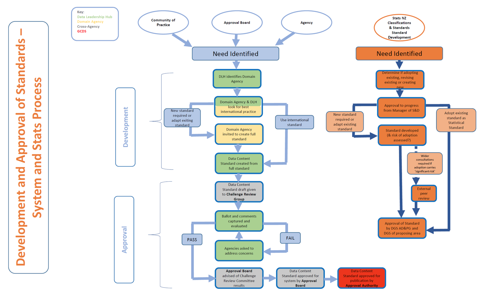
As part of its data leadership function, Statistics NZ has been developing a data standard
development and approval process which leverages its existing statistics classification experience.
This process is pragmatic and takes a project management approach to delivery which includes up-
front needs identification and resourcing requirements. It also includes leveraging international
standards work where applicable.
ACT
UNDER
INFORMATION
RELEASED
OFFICIAL
Statistics NZ Draft proposed standards development process
ISO and OGC have well established standards development processes for geospatial standards.
THE
When LINZ identifies a need that aligns with ISO or OGC, LINZ experts should participate. Because
ISO standards are not openly available, but OGC standards are, LINZ should strategically push for all
new standard work to be solely done by OGC working groups or with OGC and ISO joint working
groups.
29
Again, because ISO isn’t providing open standards LINZ should review its long-term future managing
NZ's engagement with ISO/TC211's work programme and the Joint Standards Australia/Standards NZ
Committee involvement.
Recommendation: LINZ should work with Stats NZ to leverage the data standard development
process for standards going forward.
Recommendation: Provide standards development foundations for the wider LINZ data
management teams to use - including templates, collaboration methods, review and maintenance
processes.
Recommendation: LINZ should continue to work with OGC groups or with OGC and ISO joint groups
for standards development where applicable.
ACT
Recommendation: LINZ for the medium term should continue to managing NZ's engagement with
ISO/TC211's, with focus on effort to LINZ outcomes.
Geospatial Functional Leader
While the Geospatial Office’s vision of a National SDI has not been fully effective, there are elements
that are still important to carry out to achieve LINZ’s desired outcomes. These elements include
UNDER
standardisation, linking, publishing, use and discovery of geospatial data. This leadership will be
critical to successful delivery of High-value Geographic key datasets which require collaboration with
many other agencies.
To make LINZ effective in Geographic information we need to take a pragmatic approach for the
development and implementation of standards. We have the focus areas correct, we only need to
change the approach and better resource the limited resources to make real impact. Focus should
INFORMATION
first be placed on getting our current functions and processes working well, then LINZ can promote
and further development the reusable of what we have achieved.
Recent government changes have occurred in the data and information domain with Stats NZ taking
RELEASED
the Data and Information functional leadership role. This role is heavily connected with the
refocused DIA GCDO roles that focuses on digital and information technology. Stats NZ leadership
role is still very new and will take some time to mature. DIA and StatsNZ have jointly been making
recent strategic changes to the data.govt.nz service to support new Data Catalog Vocabulary (DCAT)
OFFICIAL
standards for making government data accessible as well as publishing small to medium size
datasets on behalf of other agencies.
Recommendation: LINZ promotes the value of geospatial standardisation with other government
and crown agencies. This should focus on convincing agencies to use geospatial standards when
THE
publishing data, and best practices for using spatial data types, coordinates systems and
transformations.
Recommendation: LINZ should work with Stats NZ on how LINZ with its Geographic Information
expertise can best support the government data and information function.
30
Recommendation: LINZ should work with DIA & Stats NZ (data.govt.nz) to gain all of government
alignment and positioning for spatial data publishing/accessibility services and standards.
Recommendation: Promote the syndicated data service subscription as a blueprint for successfully
publishing data.
Data Management
To continue the evolution to a data centric organisation, provide consistency, and deliver higher
quality products LINZ needs to create improved data development functions and processes for the
data it manages. The key functions should be:
● Customer requirements
● Standards, policies, and procedures
ACT
● Metadata
● Storage
● Publishing
● Maintenance
The functions that define the data product itself, such as requirements, standards, and storage
UNDER
should sit within the LINZ data product teams to ensure the correct customer knowledge and
domain expertise is applied during development. This will ensure pragmatic results are delivered.
The team should be constantly engaging with key customers to determine and prioritise product
requirements. Defined open standards, policies, and procedures will provide the team foundations
for delivery of a consistent and high-quality product. Where applicable, the team should leverage
the organisational policies and standard development processes and lead the standards
INFORMATION
development at the national and international level.
Recommendation: Ensure that all LINZ data management teams implement the LINZ Data and
Information Management policies. This includes assigning formal roles.
RELEASED
Recommendation: The
function to develop the standard for data products should sit within the LINZ
product teams.
Recommendation: Ensure that all LINZ data management processes are evolved to include the
OFFICIAL
definition of open standards, policies, and procedures to support customer requirements.
Geospatial Technology
LINZ has successfully implemented and promoted OGC/ISO metadata and technology standards.
THE
However current standards are lagging behind mainstream IT, or in some cases do not meet
customer requirements. With LINZ’s knowledge of operating the LDS and how customers use our
data, LINZ can play a large role in operationalising OGC standards in conjunction with other
international experts, open source software developers and commercial vendors. This role directly
supports LINZ outcome areas for making data accessible and integrated for customers. It also
provides a capability to drive further reuse from existing data and attract new customer types.
31
Recommendation: LINZ participates in the development of new OGC API standards to ensure NZ
services have fit for purpose, adopted, and modern data access mechanisms.
Recommendation: LINZ works with technology communities and vendors to ensure OGC technology
standards are robustly implemented.
Recommendation: Ensure tools are available to support the creation and maintenance of geospatial
metadata.
Governance
The data management within LINZ should be governed across the business to ensure that
organisational policies are implemented and initiatives are sufficiently aligned and resourced
ACT
for business goals. The Geographic Information key datasets should be the focus within this
group. The main functions that the governance should provide oversight of are:
● Leadership alignment to ensure data aspects of the LINZ outcomes are delivered.
● Case/value for new data investment, taking different lens/use cases into considering (e.g
specific areas of water, Resilience and climate change, and urban development)
● Considering Business integrations
● Setting and monitoring implementation of policies, high level processes and frameworks for
UNDER
data management
Recommendation: LINZ Establishes operational governance that provides leadership alignment,
sponsorship, oversight and monitoring over data management activities.
INFORMATION
RELEASED
OFFICIAL
THE
32
Appendix A - People Interviewed
Name
Role
Organisation
[ s 9(2)(ba)(i) ]
[ s 9(2)(ba)(i) ]
Horizons Regional Council
[ s 9(2)(ba)(i) ]
[ s 9(2)(ba)(i) ]
ISO
[ s 9(2)(ba)(i) ]
[ s 9(2)(ba)(i) ]
OGC
[ s 9(2)(ba)(i) ]
[ s 9(2)(ba)(i) ]
OGC
ACT
[ s 9(2)(ba)(i) ]
[ s 9(2)(ba)(i) ]
NIWA
[ s 9(2)(ba)(i) ]
[ s 9(2)(ba)(i) ]
Esri Redlands USA
UNDER
[ s 9(2)(ba)(i) ]
Senior Business Architect
LINZ
[ s 9(2)(ba)(i) ]
[ s 9(2)(ba)(i) ]
Landcare
[ s 9(2)(ba)(i) ]
Manager Geodetic
LINZ
Infrastructure INFORMATION
[ s 9(2)(ba)(i) ]
SDI Technical Leader
LINZ
RELEASED
[ s 9(2)(ba)(i) ]
SDI Technical Leader
LINZ
[ s 9(2)(ba)(i) ]
Programme Lead IPS
LINZ
OFFICIAL
[ s 9(2)(ba)(i) ]
Hydro Leadership Team
LINZ
THE
[ s 9(2)(ba)(i) ]
LINZ Data Service Manager
LINZ
[ s 9(2)(ba)(i) ]
Senior Spatial Analyst
LINZ
33
[ s 9(2)(ba)(i) ]
Manager Resilience
LINZ
[ s 9(2)(ba)(i) ]
Manager Topographic Data
LINZ
[ s 9(2)(ba)(i) ]
Technical Leader Data
LINZ
[ s 9(2)(ba)(i) ]
[ s 9(2)(ba)(i) ]
Koordinates Limited
[ s 9(2)(ba)(i) ]
[ s 9(2)(ba)(i) ]
Statistics New Zealand
[ s 9(2)(ba)(i) ]
[ s 9(2)(ba)(i) ]
Statistics New Zealand
ACT
UNDER
INFORMATION
RELEASED
OFFICIAL
THE
34