

Lake Okareka Fire Station
1982
Geotechnical Assessment Report
Act
Information
Official
the
under
Released
link to page 4 link to page 4 link to page 4 link to page 4 link to page 5 link to page 5 link to page 5 link to page 5 link to page 5 link to page 6 link to page 6 link to page 6 link to page 7 link to page 7 link to page 8 link to page 8 link to page 9 link to page 9 link to page 9 link to page 10 link to page 10 link to page 10 link to page 10 link to page 10 link to page 11 link to page 11 link to page 12 link to page 12 link to page 13 link to page 13 link to page 13

Geotechnical Assessment Report
Contents
1.
Introduction ........................................................................................................................................................ 4
2.
Scope ................................................................................................................................................................... 4
3.
Proposed Development .................................................................................................................................... 4
4.
Site Description .................................................................................................................................................. 4
5. Regional Geology ............................................................................................................................................... 5
1982
5.1. Local Site Geology ................................................................................................................................ 5
5.2.
Fault Hazard .......................................................................................................................................... 5
Act
6. Geotechnical Investigations .............................................................................................................................. 5
7.
Ground Conditions ............................................................................................................................................. 5
8. Engineering Considerations .............................................................................................................................. 6
8.1. Introduction .......................................................................................................................................... 6
8.2.
Soil Design Parameters ........................................................................................................................ 6
8.3.
Seismic Consideration.......................................................................................................................... 7
8.3.1.
Peak Ground Acceleration ................................................................................................................. 7
8.3.2.
Faulting .................................................................................................................................................. 8
Information
8.3.3.
Liquefaction Assessment .................................................................................................................... 8
8.3.4.
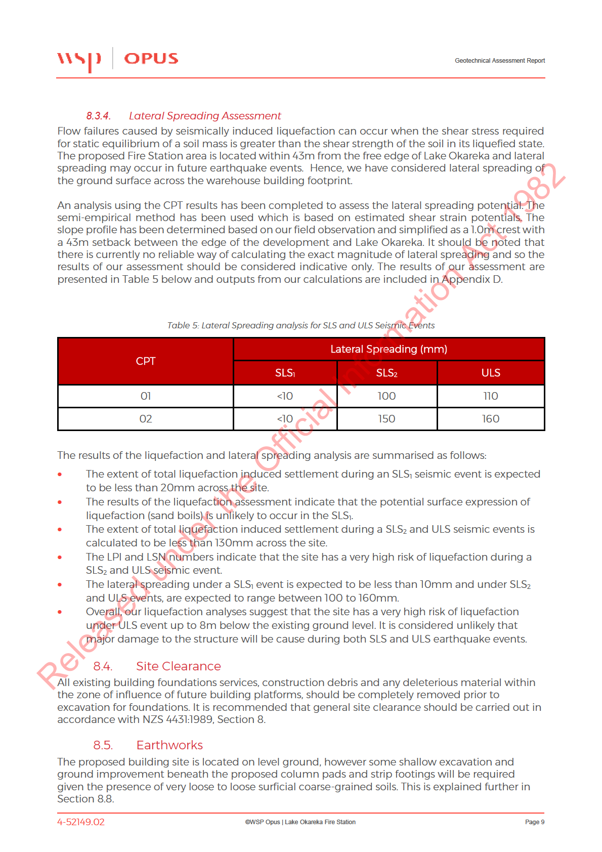
Lateral Spreading Assessment .......................................................................................................... 9
8.4.
Site Clearance ....................................................................................................................................... 9
8.5.
Earthworks ............................................................................................................................................. 9
8.6.
Inundation by Flood Waters .............................................................................................................. 10
8.7.
Building Foundations
Official
......................................................................................................................... 10
8.7.1.
Overview .............................................................................................................................................. 10
8.7.1.
Structural Loads ................................................................................................................................. 10
the
8.7.2.
Foundation Bearing Capacities ....................................................................................................... 10
8.7.3.
Floor Slab – Subgrade Modulus ....................................................................................................... 11
8.8.
Shallow Ground Improvement ......................................................................................................... 11
8.9.
Foundation Settlement ..................................................................................................................... 12
8.10.
Stormwater and Effluent Disposal
under
................................................................................................... 12
9. Further Work ................................................................................................................................................... 13
10.
Conclusions and Recommendations ........................................................................................................... 13
11. Limitations ....................................................................................................................................................... 13
Released
4-52149.02
©WSP Opus | Lake Okareka Fire Station
Page 3

Geotechnical Assessment Report
1. Introduction
WSP Opus has been engaged by Fire and Emergency NZ to undertake a geotechnical assessment
with foundation recommendations for a proposed portal frame fire station building on the corner
of Acacia and Okareka Loop Roads, Rotorua. The proposed fire station will be an Importance Level
4 structure in accordance with the requirements of 1170.0:2005.
The purpose of this report is to provide an assessment of the geotechnical risks and issues with
methods to mitigate any such risks and provide foundation recommendations for the foundations
1982
to be used for the building development. We understand this report will be used as part of the
building consent application.
2.
Act
Scope
To provide a geotechnical assessment and foundation recommendations for the proposed fire
station building. The following works were undertaken, as set out in the scope and fee proposal
letter dated the 6th June 2018 (REF 4000.nz):
•
A desktop study (review of the local site geology, aerial photos and the Rotorua Lakes
Council (RLC) hazard maps;
•
A site walkover to identify any site specific geotechnical constraints to the proposed
development and finalise the proposed investigation scope;
•
Information
Two Cone Penetrometer Tests (CPTs) to a target depth of 20m within the building platform
to confirm ground conditions and engineering properties;
•
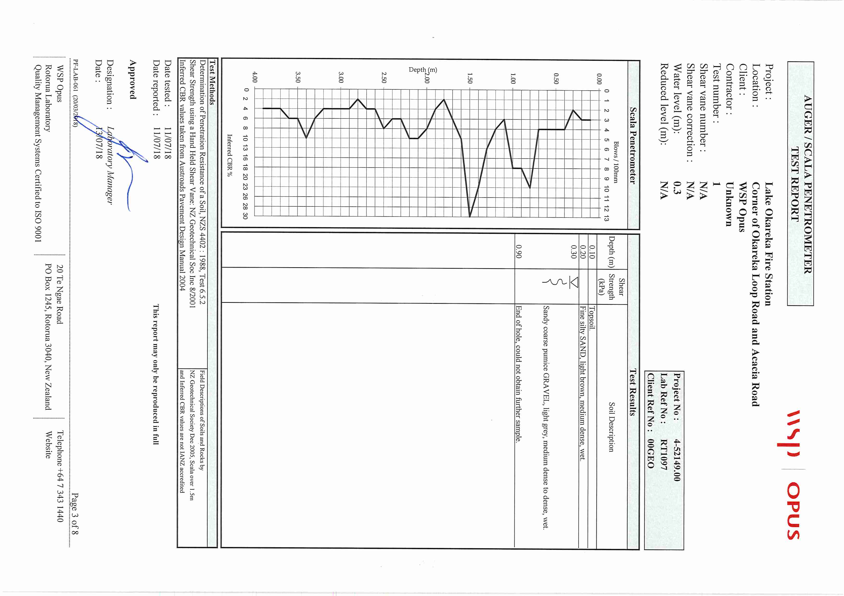
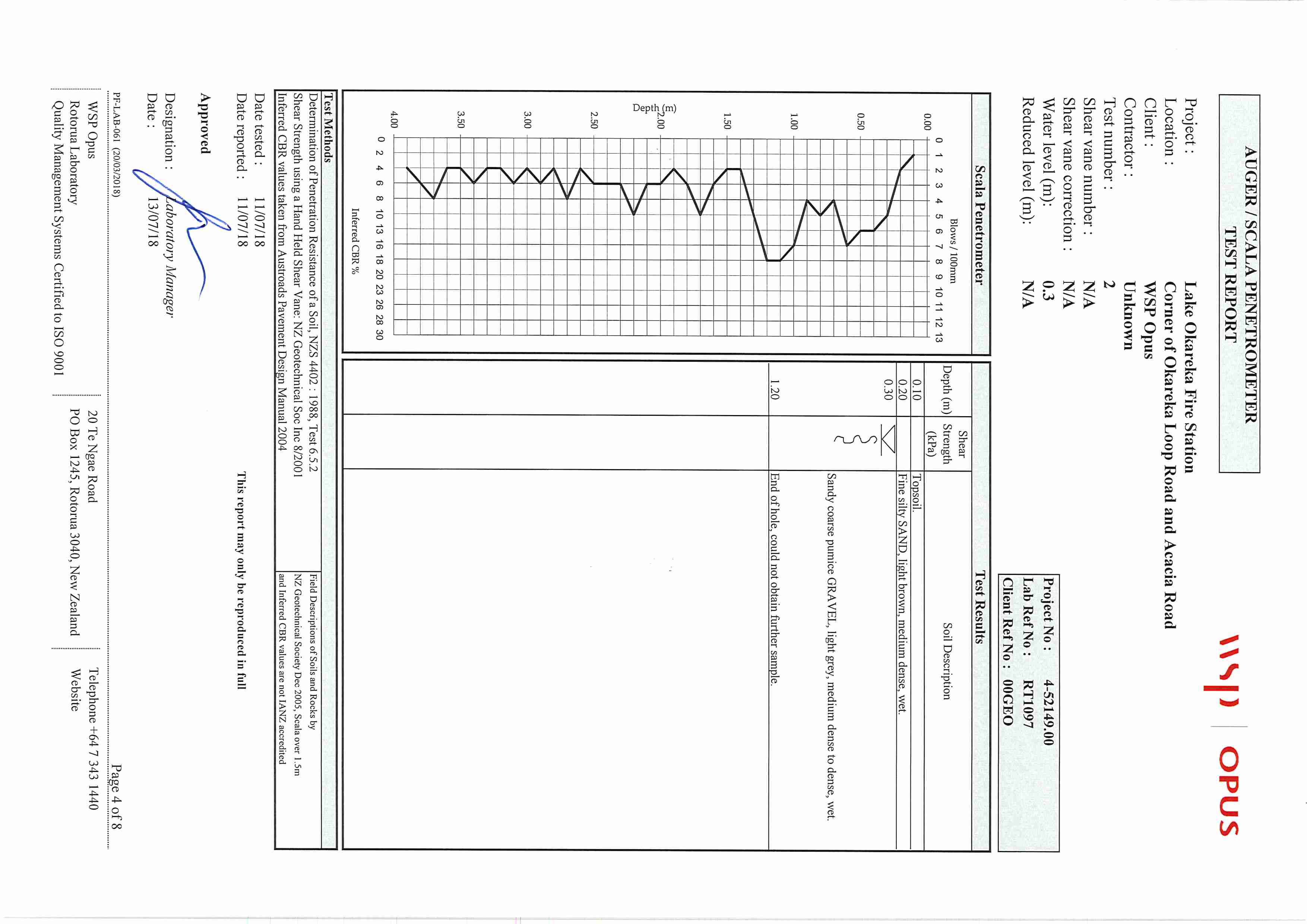
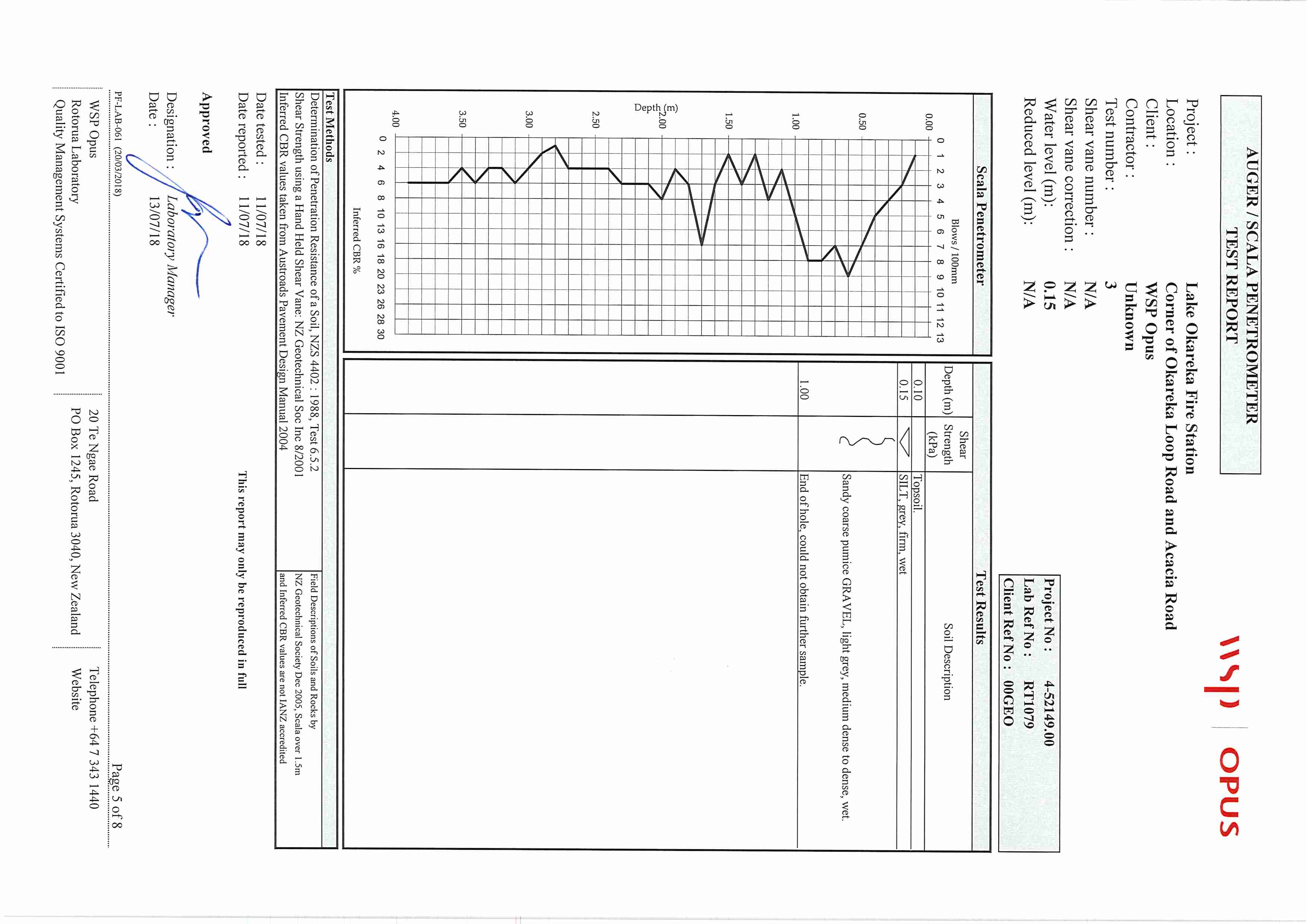
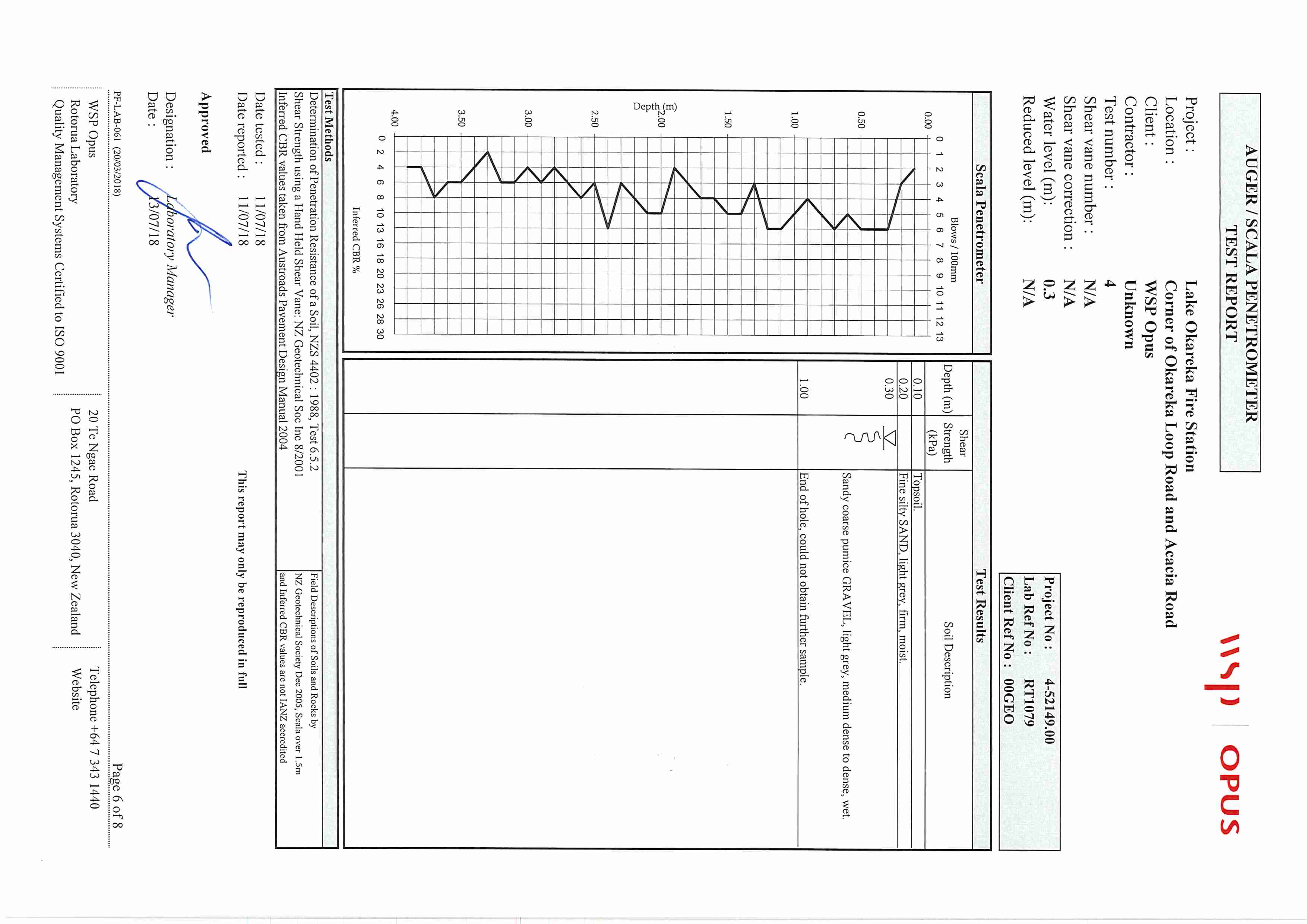
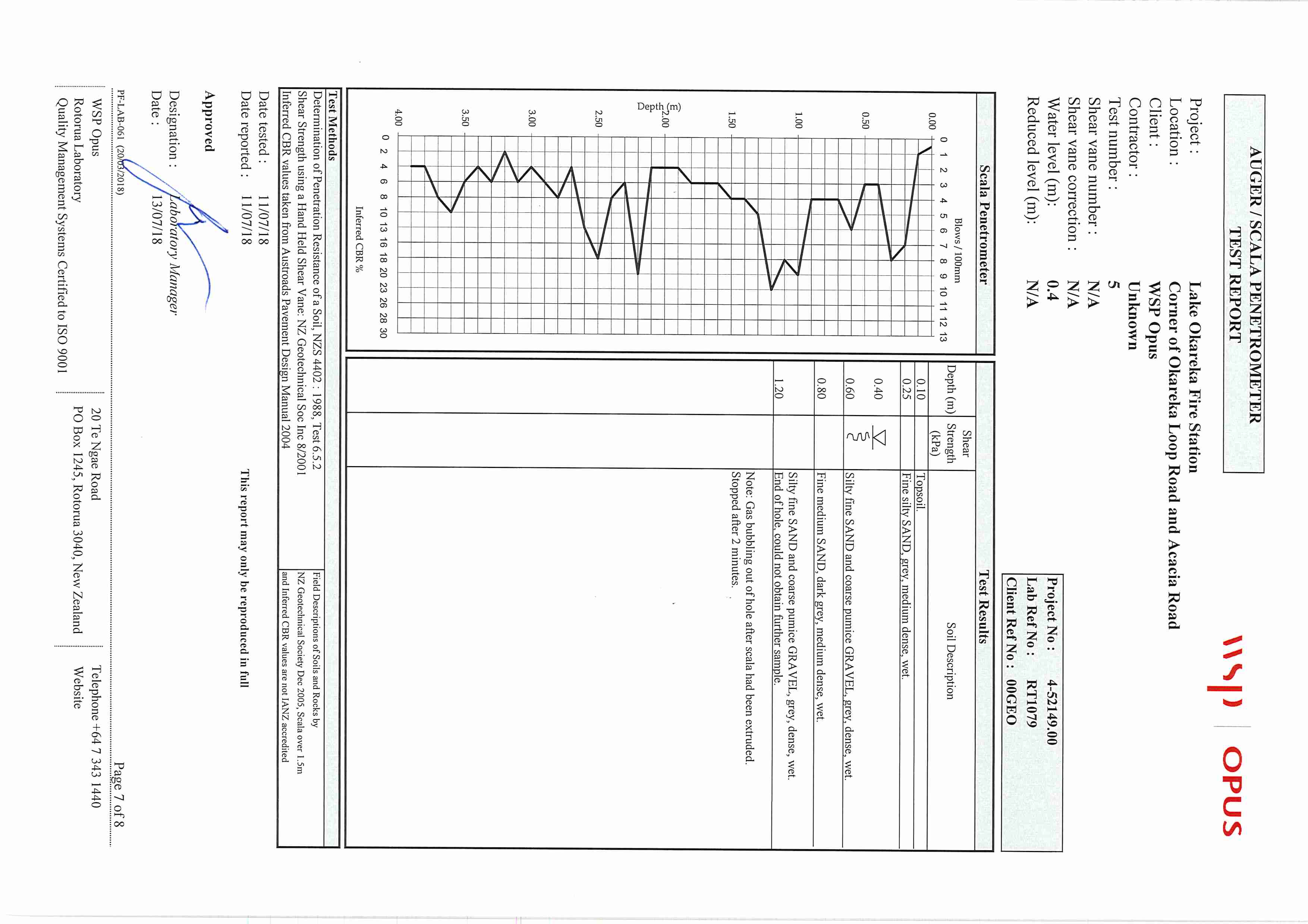
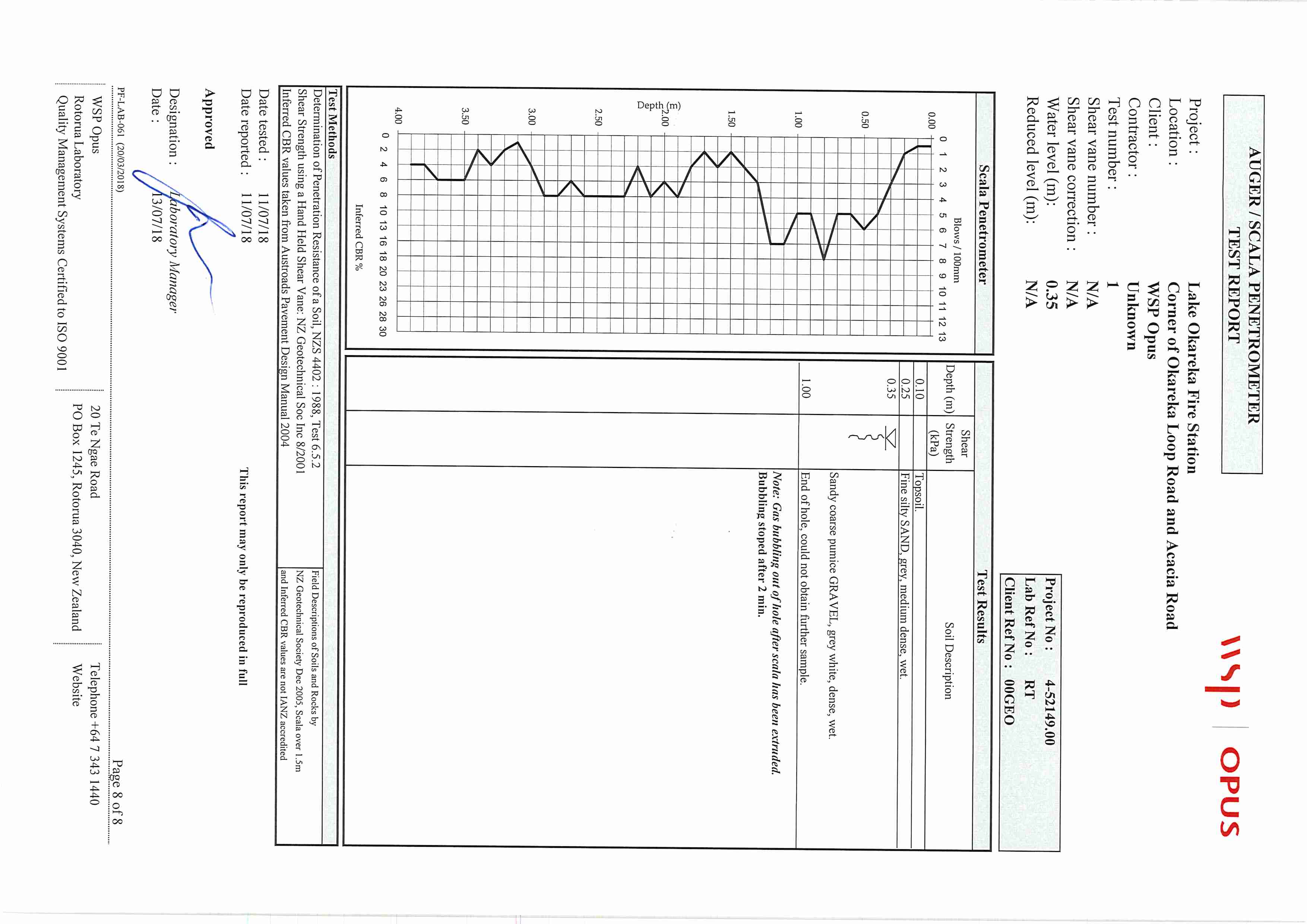
Six Hand Auger and accompanying Scala Penetrometer tests (HAS) to a target depth of
4.0m within the proposed building platform to confirm the ground conditions and
engineering properties;
•
Preparation and issue of a geotechnical assessment report providing geotechnical design
Official
parameters for building foundation recommendations and the result of the analysis and
interpretation regarding geotechnical risk to the site.
the
3. Proposed Development
We understand the proposed structure will have a maximum building footprint of 400m2. The
building will be founded on steel columns with reinforced concrete column pads and strip
footings.
under
4. Site Description
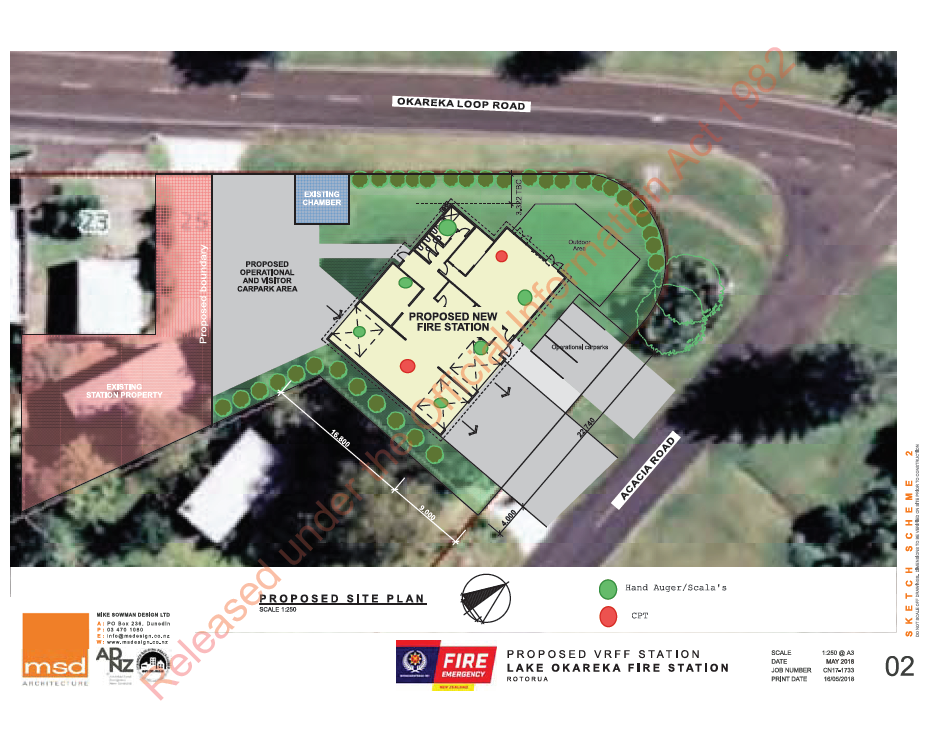
The proposed site is located on the corner of Acacia and Okareka Loop Roads, Rotorua as shown in
Appendix A – Location. The site is approximately 45m from the edge of Lake Okareka in an area
prone to flooding. The ground is topographically flat with no sloped ground near the
development.
Released
4-52149.02
©WSP Opus | Lake Okareka Fire Station
Page 4

Geotechnical Assessment Report
5. Regional Geology
5.1.
Local Site Geology
The Rotorua Lakes Councils1 Geyserview indicates the property is located in undifferentiated
Holocene alluvium known as zone C. The New Zealand Geological map of the Rotorua Area2
shows this area as part of the Pokopoko Formation, consisting of Rhyolite Ignimbrite dominated
by lapilli- to block sized pumice clasts.
5.2.
Fault Hazard
1982
The site is in a region of frequent seismic activity and within the topographic margin of various
caldera structures, which are geomorphic features of the wider Taupō Volcanic Zone (TVZ). There
are numerous active faults in the Okareka area made up of the Crater Lake Fault cluster. The
closest of these faults to the site is 400m to the south.
Act
6. Geotechnical Investigations
The objectives of the geotechnical site investigation were to collect subsoil and groundwater
information in order to provide recommendations for the proposed development the
geotechnical investigation was planned and carried out by WSP Opus Hamilton and Rotorua
Laboratories on the 11th and 12th of July 2018 and comprised of the following:
•
Shallow investigations comprising of six hand auger boreholes with associated Scala
penetrometer tests to a target depth of 4.0m below ground level;
Information
•
Deep investigations comprising of two Cone Penetrometer Tests (CPTs) up to 20.0m below
ground level or refusal.
A test location plan is presented as part of Appendix A.
7. Ground Conditions Official
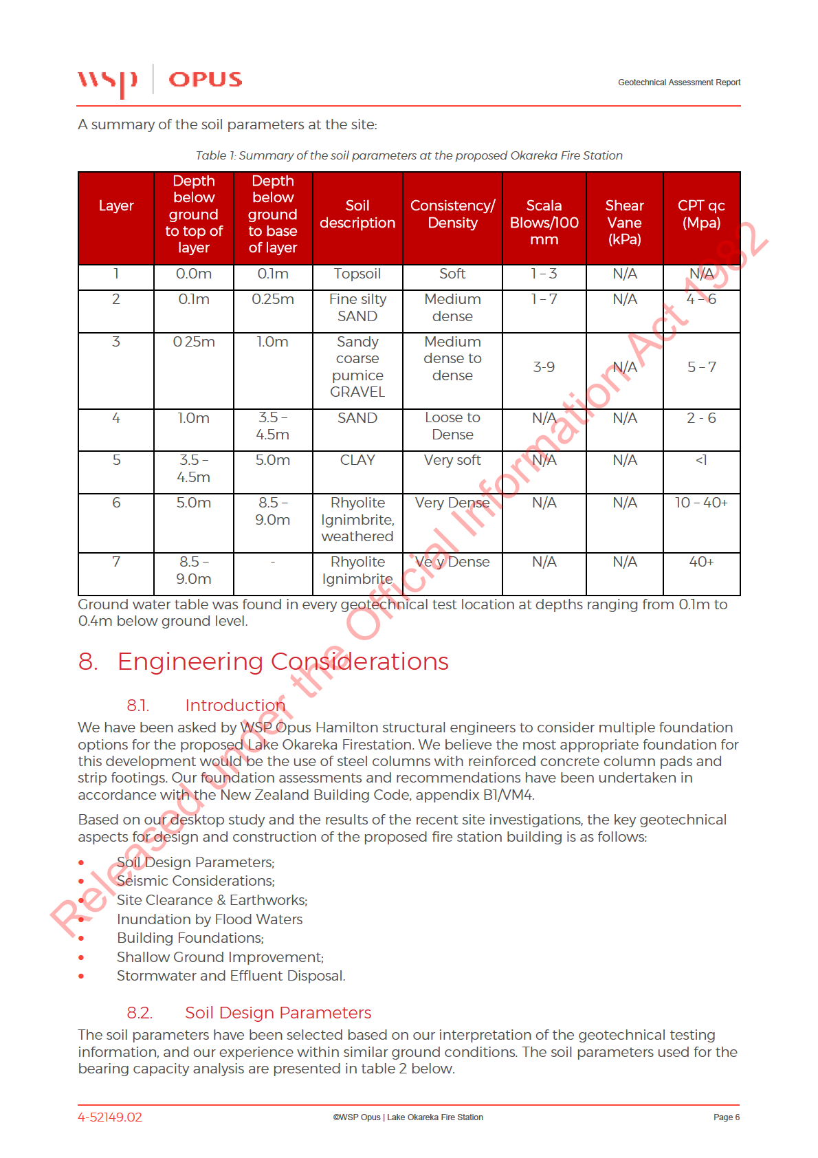
We have interpreted the results of the investigations and based on our knowledge of the soils in
the area and beneath the proposed building area. The soils below the site consist of Loose to very
the
dense sands, soft clay and potentially shallow rhyolitic ignimbrite as described by the New
Zealand Geological map of the Rotorua Area
under
Released
1 http://geo.rdc.govt.nz/Spatial/?viewer=GeyserView
2 Leaonard, G.S., Begg, J.G., Wilson, G.J.N. (compilers) 2010. Geology of Rotorua Area. Institute of
Geological & Nuclear sciences 1:250 000 geological map 5. 1 sheet + 102p. Lower Hutt, New
Zealand. GNS Science.
4-52149.02
©WSP Opus | Lake Okareka Fire Station
Page 5

Geotechnical Assessment Report
Any earthworks fill placed and compacted within the boundaries of the proposed building
platform shall be observed, tested and certified by a Chartered Professional Geotechnical
Engineer. Fill shall be placed on ground cleared free from vegetation, topsoil, and any other
deleterious material.
Excavations for building platforms may encounter very loose to loose surficial coarse-grained soils
which may be susceptible to bearing, liquefaction or differential settlement issues. Where such
materials are encountered during construction, shallow ground improvement will be required, as
outlined in Section 8.8.
The Contractor shall ensure that all excavations are benched/battered to ensure that there are safe
working conditions and adequate support to the excavation at all times.
1982
Any earthworks cuts required adjacent to existing buildings or roading may require temporary
support designed by a Chartered Professional Geotechnical Engineer, taking account soil design
parameters, retained heights and building surcharge loads etc.
Act
8.6.
Inundation by Flood Waters
As the site is located adjacent to Lake Okareka, the Fire Station floor level will need to comply with
the minimum finished floor levels (FFL) set by RLC and BOPRC to protect buildings from damage
during flood events. The minimum FFLs are expected to prevent flood damage affecting the
proposed development, and although there may be some temporary loss of amenity at the site
during extreme flood events, these effects are not expected to be significant or different to that of
the nearby dwellings on the lake shore.
RLC have confirmed this in their correspondence dated 26 July 2018 that the Lake Okareka 2%AEP
Information
flood level is RL355.5m Moturiki, inclusive of 300mm free-board allowance.
8.7.
Building Foundations
8.7.1.
Overview
As per our understanding, the proposed building foundations will comprise of either steel column
Official
concrete pad foundations with associated strip footings.
8.7.1.
Structural Loads the
WSP Opus Hamilton structural engineer advised following structural loads acting on a fire station
building column foundation.
•
Maximum column vertical load = 30kN
•
Maximum column lateral load = 35kN
•
Uplift Vertical force= 10kN
under
•
Strip footing = 10kN/m
8.7.2.
Foundation Bearing Capacities
The investigation indicates that there is a relatively dense sand crust about 2 to 3m thick across the
site underlain by about 1m of soft clay having undrained shear strength ranging between 20 to 30
kPa. Due to this variability, we consider that a reasonably conservative design approach is
warranted to minimise the risk of problems during construction.
BOPRC has advised that the minimum height of the building floor level should be RL355.5m.
Released
Therefore, the existing ground should be raised by at least 1m to fulfil the BOPRC inundation
requirement by using compacted engineered hardfill fill materials. We anticipated that the
building will be founded on this compacted engineered hardfill material. We propose that the
compacted fill will achieve 300kPa Ultimate Bearing Capacity.
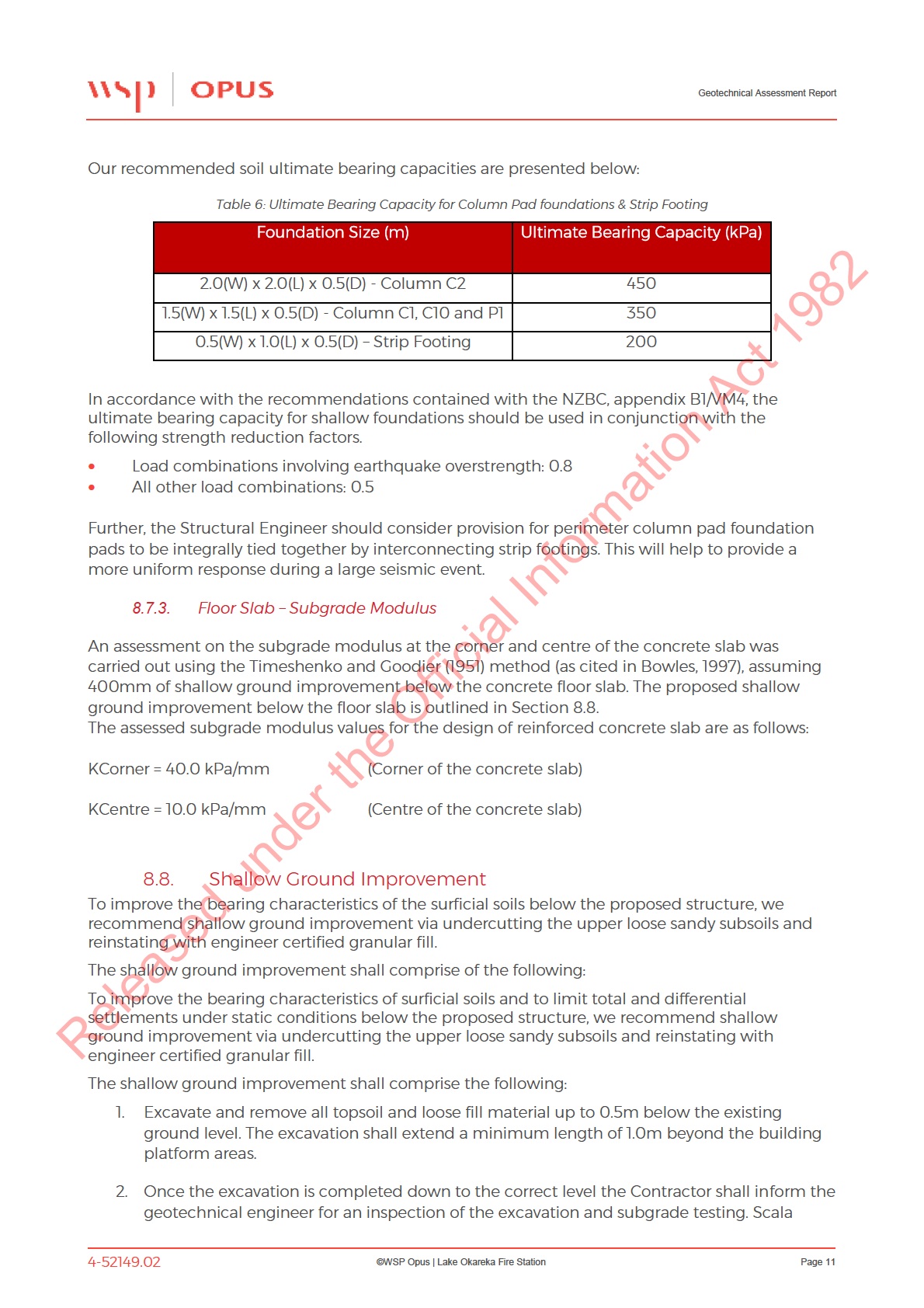
We have also assessed the ultimate bearing capacity for a range of foundation sizes is accordance
with NZBC, appendix B1/VM4. Following shallow ground improvement, the ultimate bearing
capacities presented in table 6 below may be assumed for the design of column pad foundations.
4-52149.02
©WSP Opus | Lake Okareka Fire Station
Page 10

Geotechnical Assessment Report
9. Further Work
During excavation for foundations and prior to shallow ground improvement works, it is prudent
we are given the opportunity to undertake site observations and perform any necessary additional
in-situ testing. If ground conditions vary from those assumed within the design, we would also be
on hand to recommend the most appropriate design or construction modifications.
All fill material shall be tested and certified by the chartered professional geotechnical engineer.
WSP Opus will require a minimum of 24 hours’ notice for construction observations and
geotechnical testing prior to commencement of foundation excavations.
1982
10. Conclusions and Recommendations
Based on our geotechnical analysis, we have made following conclusion and recommendations:
Act
•
Based on our site inspection and council topographical information, the site is located on a
level ground. We anticipated that minor earthworks will be required to create a level
building platform.
•
Any earthworks filling within the boundaries of the proposed building platforms shall be
observed, tested and certified by a Chartered Professional Geotechnical Engineer.
•
A shallow ground improvement is recommended for the proposed fire station building
foundation. See section 8.8 for details.
•
As per BOPRC, the minimum floor level of the building should be RL355.5m Moturiki,
Information
inclusive of 300mm free-board allowance.
•
The results of our investigation confirm that soils underlying the proposed fire station
building is suitable on which to construct shallow building foundations (either strip or pad)
after shallow ground improvement as recommended on Table 6.
•
The differential settlement under the proposed building foundations are within acceptable
limits, i.e. The maximum allowable differential settlement should be less than 25mm over a
Official
6m horizontal distance.
•
Due to the presence of shallow groundwater levels, free draining granular or volcanic derived
subsoil materials, and the general elevation of the landform at the site, the effects of
the
potential liquefaction induced vertical settlement are expected to be no greater than
120mm across the site.
•
Based on the geotechnical testing results, the ultimate bearing capacities for the various size
of steel column pad foundations and strip footings are presented on Table 6.
•
Once the excavation is completed to the founding level, the contractor shall inform the
under
geotechnical engineer for an inspection of the excavation and subgrade testing. Scala
penetrometer testing shall be performed at the base of the excavation to a depth of 0.5m,
achieving a minimum of 3 blows per 100mm of penetration.
•
Any earthworks excavations required adjacent to existing site boundaries may require
temporary support during construction. All temporary support (if required) should be
designed by a Chartered Professional Geotechnical Engineer, taking account soil design
parameters, retained heights and building surcharge loads etc.
Released
11. Limitations
The interpretation of ground conditions presented in this report is based on the tests undertaken
at discreet locations of the site. Ground conditions may change suddenly over short distances
resulting in variations between test positions across the site.
4-52149.02
©WSP Opus | Lake Okareka Fire Station
Page 13

Geotechnical Assessment Report
Data or opinions in this document may not be relied upon or used out if context, by any other
party or for any other purpose without further reference to the Tauranga Geotechnical Section of
Opus International Consultants Ltd.
It is recognised that the passage of time affects the information and assessment provide in this
Document. Opus’s opinions are based upon information that existed at the time of the production
of this Ground Conditions Report. It is understood that the services provided allowed Opus to form
no more than an opinion on the actual conditions of the site at the time the site was visited and
cannot be used to assess the effect of any subsequent changes in the quality of the site, or its
surroundings or any laws or regulations.
1982
Act
Information
Official
the
under
Released
4-52149.02
©WSP Opus | Lake Okareka Fire Station
Page 14

APPENDICIES
Appendix A
Location
1982
Act
Information
Official
the
under
Released
©WSP OPUS | DATE
PAGE 15 OF 19

APPENDICIES
Appendix B
Shallow Investigations
1982
Act
Information
Official
the
under
Released
©WSP OPUS | DATE
PAGE 16 OF 19
1982
Act
Information
Official
the
under
Released
1982
Act
Information
Official
the
under
Released
1982
Act
Information
Official
the
under
Released
1982
Act
Information
Official
the
under
Released
1982
Act
Information
Official
the
under
Released
1982
Act
Information
Official
the
under
Released

APPENDICIES
Appendix C
Deep Investigations
1982
Act
Information
Official
the
under
Released
©WSP OPUS | DATE
PAGE 17 OF 19

Cone resistance (qc) in MPa
Sleeve f riction (f s) in MPa
Dynamic pore pressure (u2) in MPa
0
2
4
6
8
10 0
0.1
0.2
0.3
0.4
0.5 -0.2
0
0.2
0.4
0.6
0.8
0
-1
-2
l
-3
ve
le
ce
n
-4
re
fe
re
-5
to
1982
m
in
th
-6
p
e
17.63 ->
Act
- D
17.83 ->
<
-7
19.37 ->
-8
37.13 ->
-9
47.42 ->
-10
-11
Information
-12
-13
Official
-14
-15
the
-16
-17
under
-18
-19
-20
-21
Released
-22
Re
R f
e usal ( qc 40+
+ MP
M a
P
a )
EO
E H
O
H -
Di
D pped
e - GW
G L
W @ 0.4m
u2
Test according A STM D5778-12 & ISO 22476-1:2012
Predril :
0.00 m Pre drille d
1
5
0 cm²
G.L.:
0.00 m M SL
W.L.:
-0.40 m
Date:
11/07/2018
1
0 cm²
Cone no.:
Project:
Lake Okareka Firestation
C10CFIIP.C15211
4
.4
Location:
Okareka Loop Rd - Lake Okareka
Project no.:
4-52149.02_HA3040
1
Position:
1893208, 5769393 NZTM
CPT no.:
01
1/6

Corrected cone resistance (qt) in MPa
Friction ratio (Rf ) in %
Excess pore pressure (du) in MPa
0
2
4
6
8
10 0
2
4
6
8
10 -0.2
0
0.2
0.4
0.6
0.8
0
-1
-2
l
-3
ve
le
ce
n
-4
re
fe
re
-5
to
1982
m
in
th
-6
p
e
17.639 ->
Act
- D
17.841 ->
<
-7
19.387 ->
-8
37.141 ->
-9
47.44 ->
-10
-11
Information
-12
-13
Official
-14
-15
the
-16
-17
under
-18
-19
-20
-21
Released
-22
Re
R f
e usal ( qc 40+
+ MP
M a
P
a )
EO
E H
O
H -
Di
D pped
e - GW
G L
W @ 0.4m
u2
Test according A STM D5778-12 & ISO 22476-1:2012
Predril :
0.00 m Pre drille d
1
5
0 cm²
G.L.:
0.00 m M SL
W.L.:
-0.40 m
Date:
11/07/2018
1
0 cm²
Cone no.:
Project:
Lake Okareka Firestation
C10CFIIP.C15211
4
.4
Location:
Okareka Loop Rd - Lake Okareka
Project no.:
4-52149.02_HA3040
1
Position:
1893208, 5769393 NZTM
CPT no.:
01
2/6

qnorm [Qt]
Normalised f riction ratio (f norm) in %
Pore pressure ratio (Bq)
0
200
400
600
800
1000
2
4
6
8
10 -0.1
0
0.1
0.2
0.3
0.4
0
-1
-2
l
-3
ve
le
ce
n
-4
re
fe
re
-5
to
m
in
th
-6
p
e
- D
<
-7
-8
-9
-10
-11
-12
-13
-14
-15
-16
-17
under the Official Information Act 1982
-18
-19
-20
21
Released
-22
Re
R f
e usal ( qc 40+
+ MP
M a
P
a )
EO
E H
O
H -
Di
D pped
e - GW
G L
W @ 0.4m
u2
Test according A STM D5778-12 & ISO 22476-1:2012
Predril :
0.00 m Pre drille d
1
5
0 cm²
G.L.:
0.00 m M SL
W.L.:
-0.40 m
Date:
11/07/2018
1
0 cm²
Cone no.:
Project:
Lake Okareka Firestation
C10CFIIP.C15211
4
.4
Location:
Okareka Loop Rd - Lake Okareka
Project no.:
4-52149.02_HA3040
1
Position:
1893208, 5769393 NZTM
CPT no.:
01
3/6

Soil Classification (using Fr)
Soil Classification (using Bq)
0
(7)
(7)
(0) Not defined
-1
(1) Sensitive, fine grained
(2) Organic soils-peats
(6)
(6)
-2
(3) Clays-clay to silty clay
(6)
(4) Clayey silt to silty clay
(6)
l
-3
(5) Sand mixtures
(5)
ve
le
(6) Sands
(6)
(6)
ce
n
-4
(3)
(3)
(7) Gravelly sand to sand
re
(3)
fe
(8) Very stiff sand to clayey sand
re
-5
(5)
(6)
(9) Very stiff fine grained
to
1982
m
(6)
in
(6)
th
(7)
-6
p
e
(7)
(6)
Act
- D
<
-7
(6)
(7)
-8
(6)
(6)
(7)
-9
-10
-11
Information
-12
-13
Official
-14
-15
the
-16
-17
under
-18
-19
-20
-21
Released
-22
u2
Test according A STM D5778-12 & ISO 22476-1:2012
Predril :
0.00 m Pre drille d
1
5
0 cm²
G.L.:
0.00 m M SL
W.L.:
-0.40 m
Date:
11/07/2018
1
0 cm²
Cone no.:
Project:
Lake Okareka Firestation
C10CFIIP.C15211
4
.4
Location:
Okareka Loop Rd - Lake Okareka
Project no.:
4-52149.02_HA3040
1
Position:
1893208, 5769393 NZTM
CPT no.:
01
4/6

DR in %
Internal friction angle in degrees
Equivalent SPT N60 Value
0
20
40
60
80
1000
10
20
30
40
50 0
10
20
30
40
50
0
-1
-2
l
-3
ve
le
ce
n
-4
re
fe
re
-5
to
1982
m
in
th
-6
p
e
Act
- D
<
-7
-8
-9
-10
-11
Information
-12
-13
Official
-14
-15
the
-16
-17
under
-18
-19
-20
-21
Released
-22
Re
R f
e usal ( qc 40+
+ MP
M a
P
a )
EO
E H
O
H -
Di
D pped
e - GW
G L
W @ 0.4m
u2
Test according A STM D5778-12 & ISO 22476-1:2012
Predril :
0.00 m Pre drille d
1
5
0 cm²
G.L.:
0.00 m M SL
W.L.:
-0.40 m
Date:
11/07/2018
1
0 cm²
Cone no.:
Project:
Lake Okareka Firestation
C10CFIIP.C15211
4
.4
Location:
Okareka Loop Rd - Lake Okareka
Project no.:
4-52149.02_HA3040
1
Position:
1893208, 5769393 NZTM
CPT no.:
01
5/6

Soil behaviour type index (Ic)
Su(min) in kPa
Su(max) in kPa
0
1
2
3
4
5
0
50
100
150
200
2500
50
100
150
200
250
0
-1
-2
l
-3
ve
le
ce
n
-4
re
fe
re
-5
to
1982
m
in
th
-6
p
e
Act
- D
<
-7
-8
-9
-10
-11
Information
-12
-13
Official
-14
-15
the
-16
-17
under
-18
-19
-20
-21
Released
-22
7
6
5 4
3
2
Re
R f
e usal ( qc 40+
+ MP
M a
P
a )
EO
E H
O
H -
Di
D pped
e - GW
G L
W @ 0.4m
u2
Test according A STM D5778-12 & ISO 22476-1:2012
Predril :
0.00 m Pre drille d
1
5
0 cm²
G.L.:
0.00 m M SL
W.L.:
-0.40 m
Date:
11/07/2018
1
0 cm²
Cone no.:
Project:
Lake Okareka Firestation
C10CFIIP.C15211
4
.4
Location:
Okareka Loop Rd - Lake Okareka
Project no.:
4-52149.02_HA3040
1
Position:
1893208, 5769393 NZTM
CPT no.:
01
6/6

Cone resistance (qc) in MPa
Sleeve f riction (f s) in MPa
Dynamic pore pressure (u2) in MPa
0
2
4
6
8
10 0
0.1
0.2
0.3
0.4
0.5 -0.2
0
0.2
0.4
0.6
0.8
0
-1
-2
l
-3
ve
le
ce
n
-4
re
fe
re
-5
to
1982
m
in
th
-6
13.06 ->
p
e
15.03 ->
Act
- D
16.28 ->
<
-7
18.93 ->
-8
-9
-10
-11
Information
-12
-13
Official
-14
-15
the
-16
-17
under
-18
-19
-20
-21
Released
-22
Re
R f
e usal ( qc 40+
+ MP
M a
P
a )
EO
E H
O
H -
Di
D pped
e - GW
G L
W @ 0.1m
u2
Test according A STM D5778-12 & ISO 22476-1:2012
Predril :
0.00 m Pre drille d
1
5
0 cm²
G.L.:
0.00 m M SL
W.L.:
-0.10 m
Date:
11/07/2018
1
0 cm²
Cone no.:
Project:
Lake Okareka Firestation
C10CFIIP.C15214
4
.4
Location:
Okareka Loop Rd - Lake Okareka
Project no.:
4-52149.02_HA3040
1
Position:
1893210, 5769384 NZTM
CPT no.:
02
1/6

Corrected cone resistance (qt) in MPa
Friction ratio (Rf ) in %
Excess pore pressure (du) in MPa
0
2
4
6
8
10 0
2
4
6
8
10 -0.2
0
0.2
0.4
0.6
0.8
0
-1
-2
l
-3
ve
le
ce
n
-4
re
fe
re
-5
to
1982
m
in
th
-6
13.075 ->
p
e
15.04 ->
Act
- D
16.291 ->
<
-7
18.94 ->
-8
-9
-10
-11
Information
-12
-13
Official
-14
-15
the
-16
-17
under
-18
-19
-20
-21
Released
-22
Re
R f
e usal ( qc 40+
+ MP
M a
P
a )
EO
E H
O
H -
Di
D pped
e - GW
G L
W @ 0.1m
u2
Test according A STM D5778-12 & ISO 22476-1:2012
Predril :
0.00 m Pre drille d
1
5
0 cm²
G.L.:
0.00 m M SL
W.L.:
-0.10 m
Date:
11/07/2018
1
0 cm²
Cone no.:
Project:
Lake Okareka Firestation
C10CFIIP.C15214
4
.4
Location:
Okareka Loop Rd - Lake Okareka
Project no.:
4-52149.02_HA3040
1
Position:
1893210, 5769384 NZTM
CPT no.:
02
2/6

qnorm [Qt]
Normalised f riction ratio (f norm) in %
Pore pressure ratio (Bq)
0
200
400
600
800
1000
2
4
6
8
10 -0.1
0
0.1
0.2
0.3
0.4
0
-1
-2
l
-3
ve
le
ce
n
-4
re
fe
re
-5
to
m
in
th
-6
p
e
- D
<
-7
-8
-9
-10
-11
-12
-13
-14
-15
-16
-17
under the Official Information Act 1982
-18
-19
-20
21
Released
-22
Re
R f
e usal ( qc 40+
+ MP
M a
P
a )
EO
E H
O
H -
Di
D pped
e - GW
G L
W @ 0.1m
u2
Test according A STM D5778-12 & ISO 22476-1:2012
Predril :
0.00 m Pre drille d
1
5
0 cm²
G.L.:
0.00 m M SL
W.L.:
-0.10 m
Date:
11/07/2018
1
0 cm²
Cone no.:
Project:
Lake Okareka Firestation
C10CFIIP.C15214
4
.4
Location:
Okareka Loop Rd - Lake Okareka
Project no.:
4-52149.02_HA3040
1
Position:
1893210, 5769384 NZTM
CPT no.:
02
3/6

Soil Classification (using Fr)
Soil Classification (using Bq)
0
(0)
(0)
(0) Not defined
(7)
(7)
-1
(1) Sensitive, fine grained
(6)
(6)
(2) Organic soils-peats
(6)
-2
(3) Clays-clay to silty clay
(7)
(6)
(6)
(4) Clayey silt to silty clay
l
-3
(5) Sand mixtures
ve
le
(3)
(6) Sands
ce
(3)
n
(4)
-4
(7) Gravelly sand to sand
re
fe
(6)
(8) Very stiff sand to clayey sand
re
(4)
(6)
-5
(9) Very stiff fine grained
to
(6)
1982
m
(5)
(6)
in
(7)
th
-6
p
e
Act
- D
<
(6)
-7
(7)
(6)
-8
-9
-10
-11
Information
-12
-13
Official
-14
-15
the
-16
-17
under
-18
-19
-20
-21
Released
-22
u2
Test according A STM D5778-12 & ISO 22476-1:2012
Predril :
0.00 m Pre drille d
1
5
0 cm²
G.L.:
0.00 m M SL
W.L.:
-0.10 m
Date:
11/07/2018
1
0 cm²
Cone no.:
Project:
Lake Okareka Firestation
C10CFIIP.C15214
4
.4
Location:
Okareka Loop Rd - Lake Okareka
Project no.:
4-52149.02_HA3040
1
Position:
1893210, 5769384 NZTM
CPT no.:
02
4/6

DR in %
Internal friction angle in degrees
Equivalent SPT N60 Value
0
20
40
60
80
1000
10
20
30
40
50 0
10
20
30
40
50
0
-1
-2
l
-3
ve
le
ce
n
-4
re
fe
re
-5
to
1982
m
in
th
-6
p
e
Act
- D
<
-7
-8
-9
-10
-11
Information
-12
-13
Official
-14
-15
the
-16
-17
under
-18
-19
-20
-21
Released
-22
Re
R f
e usal ( qc 40+
+ MP
M a
P
a )
EO
E H
O
H -
Di
D pped
e - GW
G L
W @ 0.1m
u2
Test according A STM D5778-12 & ISO 22476-1:2012
Predril :
0.00 m Pre drille d
1
5
0 cm²
G.L.:
0.00 m M SL
W.L.:
-0.10 m
Date:
11/07/2018
1
0 cm²
Cone no.:
Project:
Lake Okareka Firestation
C10CFIIP.C15214
4
.4
Location:
Okareka Loop Rd - Lake Okareka
Project no.:
4-52149.02_HA3040
1
Position:
1893210, 5769384 NZTM
CPT no.:
02
5/6

Soil behaviour type index (Ic)
Su(min) in kPa
Su(max) in kPa
0
1
2
3
4
5
0
50
100
150
200
2500
50
100
150
200
250
0
-1
-2
l
-3
ve
le
ce
n
-4
re
fe
re
-5
to
1982
m
in
th
-6
p
e
Act
- D
<
-7
-8
-9
-10
-11
Information
-12
-13
Official
-14
-15
the
-16
-17
under
-18
-19
-20
-21
Released
-22
7
6
5 4
3
2
Re
R f
e usal ( qc 40+
+ MP
M a
P
a )
EO
E H
O
H -
Di
D pped
e - GW
G L
W @ 0.1m
u2
Test according A STM D5778-12 & ISO 22476-1:2012
Predril :
0.00 m Pre drille d
1
5
0 cm²
G.L.:
0.00 m M SL
W.L.:
-0.10 m
Date:
11/07/2018
1
0 cm²
Cone no.:
Project:
Lake Okareka Firestation
C10CFIIP.C15214
4
.4
Location:
Okareka Loop Rd - Lake Okareka
Project no.:
4-52149.02_HA3040
1
Position:
1893210, 5769384 NZTM
CPT no.:
02
6/6

APPENDICIES
Appendix D
Liquefaction Results
1982
Act
Information
Official
the
under
Released
©WSP OPUS | DATE
PAGE 18 OF 19

 WSP OPUS
Gartshore House, Level 3
116 Cameron Road
Tauranga 3110
Project title : Lake Okareka Fire Station
1982
Location : Lake Okareka
Act
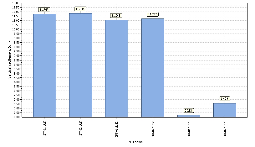
Overall vertical settlements report
Information
Official
the
under
CLiq v.2.1.6.5 - CPT Liquefaction Assessment Software
1
Released
Project file: \\opus\s\Proj\NZ\45\4-52149.02 Lake Okareka Fire Station\Home\500 Discipline Specifications\1100 Geotechnical\2.0 Site Investigation\2.2 CPT\03_Output\Lake Okareka Fire Station.clq

 WSP OPUS
Gartshore House, Level 3
116 Cameron Road
Tauranga 3110
Project title : Lake Okareka Fire Station
1982
Location : Lake Okareka
Act
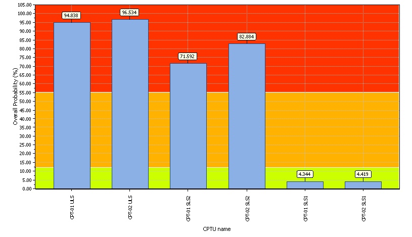
Overall Probability for Liquefaction report
Probability color scheme
Very High Probability
High Probability
Low Probability
Basic statistics
Total CPT number: 6
Information
33.33% low probability
0.00% high probability
66.67% very high probability
Official
the
under
CLiq v.2.1.6.5 - CPT Liquefaction Assessment Software
1
Released
Project file: \\opus\s\Proj\NZ\45\4-52149.02 Lake Okareka Fire Station\Home\500 Discipline Specifications\1100 Geotechnical\2.0 Site Investigation\2.2 CPT\03_Output\Lake Okareka Fire Station.clq

 WSP OPUS
Gartshore House, Level 3
116 Cameron Road
Tauranga 3110
Project title : Lake Okareka Fire Station
1982
Location : Lake Okareka
Act
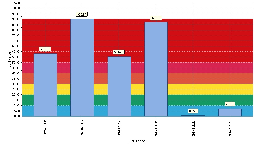
Overall Liquefaction Severity Number report
LSN color scheme
Severe damage
Major expression of liquefaction
Moderate to severe exp. of liquefaction
Moderate expression of liquefaction
Minor expression of liquefaction
Little to no expression of liquefaction
Basic statistics
Total CPT number: 6
Information
33.33% little liquefaction
0.00% minnor liquefaction
0.00% moderate liquefaction
0.00% moderate to major liquefaction
0.00% major liquefaction
66.67% severe liquefaction
Official
the
under
CLiq v.2.1.6.5 - CPT Liquefaction Assessment Software
1
Released
Project file: \\opus\s\Proj\NZ\45\4-52149.02 Lake Okareka Fire Station\Home\500 Discipline Specifications\1100 Geotechnical\2.0 Site Investigation\2.2 CPT\03_Output\Lake Okareka Fire Station.clq

 WSP OPUS
Gartshore House, Level 3
116 Cameron Road
Tauranga 3110
Project title : Lake Okareka Fire Station
1982
Location : Lake Okareka
Act
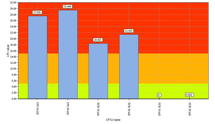
Overall Liquefaction Potential Index report
LPI color scheme
Very high risk
High risk
Low risk
Basic statistics
Total CPT number: 6
Information
33.33% low risk
0.00% high risk
66.67% very high risk
Official
the
under
CLiq v.2.1.6.5 - CPT Liquefaction Assessment Software
1
Released
Project file: \\opus\s\Proj\NZ\45\4-52149.02 Lake Okareka Fire Station\Home\500 Discipline Specifications\1100 Geotechnical\2.0 Site Investigation\2.2 CPT\03_Output\Lake Okareka Fire Station.clq

 WSP OPUS
Gartshore House, Level 3
116 Cameron Road
Tauranga 3110
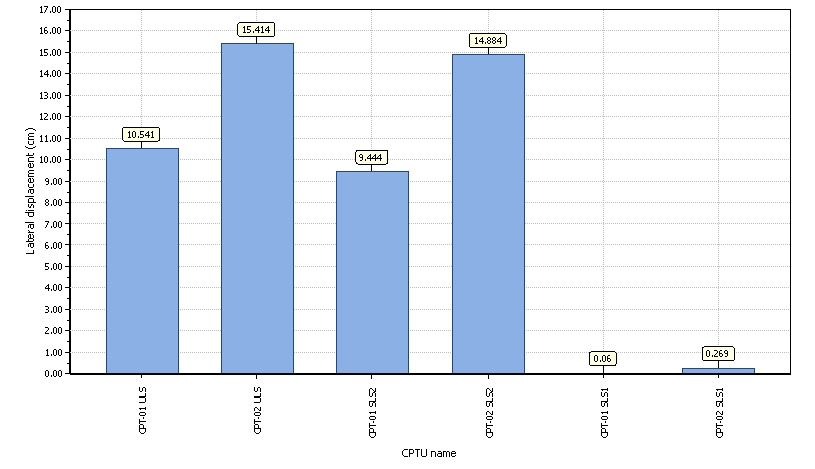
Project title : Lake Okareka Fire Station
1982
Location : Lake Okareka
Act
Overall lateral displacements report
Information
Official
the
under
CLiq v.2.1.6.5 - CPT Liquefaction Assessment Software
1
Released
Project file: \\opus\s\Proj\NZ\45\4-52149.02 Lake Okareka Fire Station\Home\500 Discipline Specifications\1100 Geotechnical\2.0 Site Investigation\2.2 CPT\03_Output\Lake Okareka Fire Station.clq