VTA permission application form - Version 3: March 2010
Application for a Permission
for the Use of Vertebrate Toxic Agent(s)
Hazardous Substances and New Organisms Act 1996 (HSNO)
ACT
This application is to be used when applying for a Permission to use any vertebrate toxic agent (VTA) approved
under the HSNO Act, for which a permission is required under section 95A of the Act.
A Permission is issued by a person acting under powers delegated by the Environmental Risk Management
Authority (“the delegated person”).
Attachments
INFORMATION
The application form contains a series of attachments requesting information necessary for issuing the
permission. Complete all of the attachments. If an attachment is not relevant, return the attachment as part of
the completed application form and write “not applicable” across it.
OFFICIAL
Return this application to the contact person below.
LOCAL PUBLIC HEALTH CONTACT
THE
Health Protection Officer
Waikato District Health Board
Huge Monckton Trust Building – L4
Cnr. Rostrevor & Harwood Streets
UNDER
Private Bag 3200
Hamilton 3240
Ph
Email
RELEASED
age 1 of 37
link to page 2
VTA permission application form - Version 3: March 2010
Guidance for Applicants
HSNO requirements for VTAs
The requirements specified under the Hazardous Substances and New Organisms (HSNO) Act, its
regulations, and Approvals for Vertebrate Toxic Agents (VTAs) granted under the HSNO Act are
minimum requirements, which must be met. Where a permission for VTA use is granted by a person
acting under a delegation from the Authority, they may impose additional (stricter) conditions to
address local circumstances.
ACT
The current HSNO Approvals for VTAs can be found by searching the register on the ERMA New Zealand
website, at:
http://www.ermanz.govt.nz/search/registers.html
Consultation required prior to aerial application of sodium fluoroacetate (1080)
Consultation is a key risk mitigation tool for aerial 1080 operations. You need to provide sufficient evidence to
satisfy the person who is assessing your application for a permission that your consultation has met the
requirements of ERMA New Zealand’s Communication Guidelines for Aerial 1080 Operations before a
permission can be issued.
The Communication Guidelines for Aerial 1080 Operations can be found on the ERMA New Zealand website
at:
http://www.ermanz.govt.nz/hs/1080resources/1080bpg.html
INFORMATION
Note:
1) You can provide copies of communication logs as evidence of consultation, rather than repeating this
evidence in this application.
2) The procedures set out in Department of Conservation’s (DoC) ‘Consultation and Notification of Pest
Operations – Standard Operating Procedures’ (SOP), are equivalent to those outlined in the Communication
Guidelines for Aerial 1080 Operations (above). If the application is made on behalf of DoC, copies of the
records created in accordance with this SOP may be provided to the Public Health Unit as evidence.
OFFICIAL
3) The evidence needs to be sufficient to satisy the person who is assessing your application that potential
risks to public health have been identified and can be avoided, remedied or mitigated.
If you are uncertain about the level of consultation required, or the evidence required of such consultation,
THE
discuss this with your local Public Health Unit.
Food Safety Considerations
The New Zealand Food Safety Authority oversees compliance with requirements
1 to ensure VTA use does not
contaminate food sources. Therefore potential pathways for contamination may be identified as part of an
application for a permission to use VTAs, and conditions may be imposed on your permission where this is
considered necessary to reduce potential risks to public health.
UNDER
Other Relevant Legislation
It is the responsibility of the applicant to ensure compliance with all relevant legislation including, but not necessarily
Compounds and Veterinary Medicines Act 1997, Resource Management Act 1991, Land Transport Act 1998, and
the Conservation Act 1987.
Transport Considerations:
VTAs must be transported in accordance with the applicable transport regulations. The following websites
provide information about requirements for transport of VTAs:
Road transport: http://www.nzta.govt.nz/resources/results.html?catid=59
RELEASED
Air transport: http://www.caa.govt.nz/Dangerous_Goods/DG_Booklet.PDF
By Ship: http://www.maritimenz.govt.nz/Rules/List-of-all-rules/Part24A-maritime-rule.asp
1 Such as the requirements of the Agricultural Compounds and Veterinary Medicines Act.
age 2 of 37
link to page 3 link to page 3
VTA permission application form - Version 3: March 2010
Application for a Permission to use a Vertebrate Toxic Agent
(Pursuant to section 95A of the Hazardous Substances and New Organisms Act 1996)
Explanatory Note: A Permission may be issued to the applicant or to a person holding a controlled substances license. If the
permission is granted to a controlled substance licensee, give his/her name and provide a copy of the controlled substance licence. If
the operation is “contracted out”, the agency conducting the operation must complete this application form, including Attachment E.
Name of applicant:
Organisation on whose behalf the VTA is to be applied: Department of Conservation
Applicant contact details (address, postal address, telephone, cell phone, facsimile, e-mail):
ACT
2/20 Joan Gaskill Drive
Whitianga
Operation Start Date: 4th September 2017
Operation Finish Date: 31st October 2017
Note: A Permission will be issued to the applicant for a maximum period of 12 months. Where an operation extends past 12 months
applicants will need to apply for replacement permission.
Operation Name: Papakai Possum Control Operation 2017
Operation Locality: Coromandel Forest Park between Tapu-Coroglen Road and 309 Road
INFORMATION
Territorial Local Authority:
2 Thames Coromandel District Council
Total operation Size (ha): 11535 hectares
If the applicant has carried out an earlier operation in this area, report:
Date of Operation:
14/05/2013
ApplicationIdentificationCode:13-259-CM-WAPH-DOC-LI-PAPAKAI
Vertebrate toxic agent,
Strength,
Form,
Application rate (for
Target species:
e.g. potassium cyanide
e.g. 800 g/kg
e.g. pellets
aerial operations)
e.g. possum
OFFICIAL
Sodium fluoroacetate (1080) 1.5 g/kg
Pellets
2kg/ha
Possums
HSNO Approval Number
(e.g. HSR0024243):
THE
Start Date: 4th September 2017
End Date: 31st October 2017
UNDER
RELEASED
2 District council, city council or unitary authority.
3 The HSNO approval number for each substance can be found on the approval for that substance.
age 3 of 37

VTA permission application form - Version 3: March 2010
Specify all methods to be used for the VTA:
If more than one VTA is involved, use the boxes on p.4. Treatment area size (ha): 11535 hectares
Methods to be used:
(Tick applicable box)
Yes
No
Yes
No
Aerial
Bait stations
Broadcast
State heights of bait stations:
Turf spits
Types of bait stations:
ACT
Traps
Other control methods
(Describe briefly below)
Name (print):
Signature:
Date: 11th August 2017
Application Identification Code:
(Office use only)
INFORMATION
OFFICIAL
THE
UNDER
RELEASED
age 4 of 37
VTA permission application form - Version 3: March 2010
ATTACHMENTS – A TO O
Complete the attachments that apply to this application. Tick the “yes/no” boxes below. If an attachment is
not relevant, write “not applicable” across it. Return all attachments.
Note that different VTAs may require varying levels of detail to be provided with the attachment. Similarly aerial
and ground operations will have different information requirements.
Page No.
Attachment Reference A to P
Information
Office use only
attached
ACT
Tick applicable box
General
YES
NO
5
A
Operational Maps
6
B
Interested Parties
7
C
Community Consultation
8
D
Consultation with Maori
9
E
Operation Delivered by Subcontractor
10
F
Transport, Storage and Disposal of VTAs
For Aerial 1080 operations: Does the consultation described in
INFORMATION
attachments C & D meet the requirements of the Communication
Guidelines for Aerial 1080 Operations?
Excluded Areas: Mark clearly on map(s)
11
G
Drinking Water Supply Catchments and
Intakes (Public and Private Commercial)
13
H
Dwellings, Adjacent Landowners/Occupiers
14
I
Areas That Are Easily Accessible
OFFICIAL
15
J
Tramping Huts and Shelters
16
K
Walking Tracks and Roads
17
L
Areas to be inspected
THE
Risk Communication
18
M
Schools and Early Childhood Centres
19
N
Notifications
20
O
Warning Notices and Information Boards
UNDER
For Aerial 1080 operations: Does the communication described
in attachments M, N & O meet the requirements of the
Communication Guidelines for Aerial 1080 Operations?
Applicant
Ensure you return all attachments with this application. If an attachment is not relevant, write “not applicable”
across it.
RELEASED
age 5 of 37
VTA permission application form - Version 3: March 2010
ATTACHMENT A:
OPERATIONAL MAPS
The use of the maps is to provide sufficient specific information for this operation.
• Provide a description of the operational area. Include here the name of the area/reserve, and the name(s)
of the landowner(s), clearly noting public and private land ownership.
• Operational maps should provide an adequate level of detail. A number of map options are available e.g.
topographical (e.g. NZS 260 series or Topo 50 Series), GIS (geographic information systems), aerial photos,
etc.
ACT
• Include:
- area ground control
0 ha
- area aerial control
11535 ha
- territorial local authority Thames Coromandel District Council
- direction and distance to nearest town: There are two major town, Coromandel Town is 11 .5
km to the north, Whitianga town is 7.5 Km to the North East.
There are three smaller town with population lest than 500 residents. Coroglen is 3.5 Km to the east, Tapu is
3.2 km to the south west Manaia is 3.8 Km to the north west Whenuakite is 10.6 Km to the south east
• If using more than one VTA, show on the map where each VTA will be applied.
• Identify where the helicopter loading zones will be and bait processing sites for carrot 1080 operations. If
there is more than one loading zone or processing site, ensure all are clearly identified. This information
INFORMATION
may also be recorded in Attachment F.
•
Attach 2 copies of operational maps: More than one map may be needed to include all the information.
Use maps of different scales if necessary. A copy of the maps (including any necessary changes) will be
returned to you and form part of the permission conditions. The second copy will be kept as a record by the
Public Health Unit.
• Identify the following on your map(s) by using a colour code, a number code or similar:
OFFICIAL
Refer to attachment
- Drinking Water Catchments and Intakes
(Public and Private Commercial Water Supplies)
(G)
THE
- Dwellings, Adjacent Landowners/Occupiers
(H)
- Areas Easily Accessible to Public
(I)
- Tramping Huts and Shelters
(J)
- Walking Tracks and Roads
(K)
- Other Excluded Areas
(L)
- Schools and Early Childhood Centres
(M)
UNDER
- Warning Notices and Information Boards
(O)
(Letters in brackets refer to corresponding attachments)
Attach: Operational maps (2 copies):
RELEASED
(For official use)
age 6 of 37
VTA permission application form - Version 3: March 2010
ACT
INFORMATION
OFFICIAL
THE
UNDER
age 7 of 37
RELEASED
VTA permission application form - Version 3: March 2010
ACT
INFORMATION
OFFICIAL
THE
UNDER
age 8 of 37
RELEASED
VTA permission application form - Version 3: March 2010
ATTACHMENT B: Interested/ Affected Parties
Do people take drinking water from water supplies where the water source originates in the operational area?
Refer to Attachments C, D and G
Consider drinking water in parks, island and camping sites even when there may be no permanent or local
population.
Yes
ACT
•
has a water intake 100 metres outside the operational boundary.
has no problem with
the operation. She has had five operations over the pass 20years she has lived there.
will
disconnect her water intake for 48 hrs after the application of bait.
has a 13,000 water tank. Refer
to the communication record.
•
is happy with the application of 1080 around his water supply, and is happy to rely on his
25 000 liters of water during the operation
only pumps water to his tank when the tank
become empty. Refer to the communication record.
•
water intake is 650 metres downstream from the operational boundary have an
exclusion placed around there water intake refer to communication record.
INFORMATION
• Whitianga intake for Whitianga Town. Whitianga intake is 5.8 km downstream in the Whangamaroro
River.
• Water intakes for Coromandel Town. Coromandel intake is 10.1 km downstream in the Waiau River.
•
has a water supply within the operational boundary.
is very supportive of the operation
and is having 37ha of his land include.
will disconnect his water supply for a week after the bait
has been applied.
•
pumps water from the Osborne Stream to a water tank. Will not pump will after the
OFFICIAL
operation. Refer to the communication record.
• Mahakirau Estate houses all have water tanks, and get there water from roof run off. All the house
have been given a 150 buffer around the houses. Refer to the communication record
THE
• Riverglen Camp Ground has a water intake 1 km in a straight line from the operational boundary.
• Riverlee Early Childhood School has a water intake 600 metres in a straight line from the operational
boundary.
• Te Mata Hut is inside the operational area. This is a DOC biodiversity hut and is not used by the public.
The water supply is is rain water from the roof. The down pipe with be disconnected be the application
of bait and the roof checked and water supply connected back into the tank after the bait application.
UNDER
• All other water sources are very low risk, Rain water collection, bores, or from streams outside the
operation catchment.
No
If no, on what is this assessment based?
Do members of the public live within or adjoining the operational boundary?
Refer to Attachments H
RELEASED
Yes
• There are 24 resident that have property within the Mahakirau Estate. most having dwellings, there
are two properties that do not have dwellings. Out of the 24 residents 19 have consented to have
aerial 1080 applied to their property and 5 are opposed to aerial 1080.
• There are a number of people adjoining to the operational area, most have been contacted but there
are a small number that have been sent letters but we do not have phone numbers for. We have
age 9 of 37
VTA permission application form - Version 3: March 2010
made attempts to contact these residents but with no luck. Some of these resident live overseas.
Papakai. Refer to the communication plan.
No
If no, on what is this assessment based?
Do the public have access to the area?
Refer Attachments C, D, I, J, K, L and O
Think about areas reached by walking tracks, roads and boating access, which can be used by the public.
Yes
ACT
• There is a number of areas public do have access to the operational area along the 309 road and the
Tapu/Coroglen road all layby areas and areas that could allow access into the operational will have
warning signs erected.
• Kaimarama and Mill Creek road are access points, but Public must cross private land to enter
operation area Warning signs will be erected at these two road ends.
Refer to attachment.
No
If no, on what is this assessment based?
Are there any schools or early childhood centres within or near the operational boundary?
Refer to
INFORMATION
Attachment M
Yes
• There are no Schools within the operational area, but there are a number of schools from the
operational boundary, ranging from 3km to 13km that have all received information regarding the
operation. Refer to attachment and the communication record.
OFFICIAL
No
If no, on what is this assessment based?
THE
Is the operational area used for outdoor pursuits, groups/clubs such as hunters, campers, trampers, mountain
bikers, scouts, schools etc?
Refer to Attachments C, D, I, J, K, N and O
Yes
• Refer to attachments I - K
UNDER
No
If no, on what is this assessment based?
Is the operational area close to a village, town, other residential area, educational centre, marae or camping
ground?
Refer to Attachments C and D
If yes, describe.
Yes
• There is one camp ground Riverglen campground 1.2 km from the operational boundary
Coroglen Township is 3.3 km from the operational boundary.
RELEASED
Manaia Town, Marae and school are all 4.5 km from the operational boundary
• Refer to attachments C and D
No
age 10 of 37
VTA permission application form - Version 3: March 2010
ATTACHMENT C: COMMUNITY CONSULTATION
Do you expect any public concern about this operation?
Yes No
If yes, describe the nature of the concern:
• Risk to farm and domestic dogs with poisoned carcasses washing down streams after rain events.
• Concerns about carcases contaminating waterways
ACT
• There has been a considerable amount of protest for the wider community with a protest march in
Whitianga.
• Mahakirau Estate have 80% support of the operation but there are five residents that not supportive.
. .
• Inability to hunt and recover pigs for the quarantine period of the area.
• Toxic bait spread outside the operational area.
• The inhumanness of the bait.
INFORMATION
•
What is the source of your information?
Consultation with adjoining landowners, residents, pig hunters, and iwi. Also, information obtained
from information and correspondence received from OIA and Ministerial with anti 1080 protesters.
If no, on what is this assessment based?
OFFICIAL
THE
UNDER
RELEASED
age 11 of 37
VTA permission application form - Version 3: March 2010
Consultation with community groups
What community groups did you consult with in relation to this application?
• Thames Coast Kiwi Care
• Peninsula Pig Hunting Club
• Whitianga Pig Hunting Club
• Coromandel Pig Hunting Club
• Thames Coast Kiwi Care
Name the individuals/groups consulted:
•
ACT
Thames Coast Kiwi AGM
• Peninsula Pig Hunting Club,
• Whitianga Pig Hunting Club,
• Coromandel Pig Hunting Club,
• Thames Coast Kiwi Care
Detail what, if any, concerns these individuals/groups identified:
• Thames Coast Kiwi Care – Were very supportive as this will assist with their predator control.work .
• Peninsula Pig Hunting Club – Opposed to aerial 1080, due to wild pig harvest from the area, toxins in
the animals and dogs eat poisoned possum carcases.
• Whitianga Pig Hunting Club – Opposed to aerial 1080, due to wild pig harvest from the area, toxins in
the animals and dogs eat poisoned possum carcases.
INFORMATION
• Coromandel Pig Hunting Club – Opposed to aerial 1080, due to wild pig harvest from the area, toxins
in the animals and dogs eat poisoned possum carcases.
• Thames Valley Deerstalkers Association - Opposed to aerial 1080
How are you planning to avoid, mitigate or remedy any adverse effects identified by these individuals/groups?
• Thames Coast Kiwi Care – Have no concern very supportive.
.
•
OFFICIAL
Peninsula Pig Hunting Club: Nothing – their objectives are not compatible with the objectives of the
Department of Conservation. All the pig hunting clubs do not want 1080 and only want the areas
trapped
• Whitianga Pig Hunting Club: Nothing – their objectives are not compatible with the objectives of the
THE
Department of Conservation. All the pig hunting clubs do not want 1080 and only want the areas
trapped
• Coromandel Pig Hunting Club: Nothing – their objectives are not compatible with the objectives of the
Department of Conservation. All the pig hunting clubs do not want 1080 and only want the areas
trapped
•
UNDER
Thames Valley Deerstalkers Association Nothing – their objectives are not compatible with the
objectives of the Department of Conservation
Attach any evidence of the consultation (correspondence, minutes of meetings, record of phone calls, etc):
Refer to the Communication plan
If you have not consulted any community groups about this application, ask the resource consent planner at
your local council to help identify the appropriate groups to contact.
RELEASED
age 12 of 37
VTA permission application form - Version 3: March 2010
Community consultation - Aerial 1080 Operations
You must provide sufficient evidence to demonstrate that consultation prior to aerial 1080 operations
has met the requirements of ERMA NZ’s Communication guidelines for aerial 1080 operations.
You can provide copies of communication logs as evidence, rather than repeating this evidence here.
Have you provided evidence to demonstrate compliance with the
Yes
No
requirements of ERMA NZ’s Communication Guidelines for Aerial 1080
Operations?
Refer to Communication plan
ACT
If you have not followed these guidelines, please explain in detail your
justification for not meeting these requirements:
INFORMATION
OFFICIAL
THE
UNDER
RELEASED
age 13 of 37
VTA permission application form - Version 3: March 2010
ATTACHMENT D: CONSULTATION WITH MAORI
When consulting with Maori, you need to take into account Section 6(d) of the HSNO Act: “The relationship
of Maori and their culture and traditions with their ancestral lands, water, sites, waahi tapu, valued flora
and fauna, and other taonga”.
What Maori groups (iwi/hapu/whanau) did you consult with in relation to this application?
• Ngaati Whanaunga
• Ngati Maru
ACT
• Ngati Tamatera
• Ngati Hei
• Ngati Pukenga
• Ngati Hako
• Ngati Huarere
• Ngati Porou
• Ngati Rahiri
List the marae provided information about this proposed operation:
• Manaia Marae (Te Kau o Rehua) iwi are: Ngaati Whanaunga / Ngati Maru
• Paeroa Marae (Pai o Hauraki) iwi are: Ngati Tamatera
• Thames Marae (Matai Whetu) iwi are: Ngati Maru
INFORMATION
Name the individuals and groups consulted:
• Enviromental represenatives from Ngati Maru, Ngati Hei, Ngaati Whanaunga, Ngati Pukenga,
and Ngati Tamatera.
• Also concerned individuals,
– Ngati Maru, and
– Ngati Hei.
Identify what, if any, concerns these individuals and groups identified:
OFFICIAL
• Ngaati Whanaunga oppose 1080 in principle but under stands the Department role in pest
control.
• Ngati Hei official position was to be kept in the loop with consultation but was not supportive of
THE
1080 but understands the Department of Conservation role in pest control
.
• Ngati Maru stands from a point of anti aerial 1080, but will not put in any objections for the
operation. Which is no change from the past.
, Ngati Maru represents a small
community of pig hunters in the area who have made it very clear they don’t want any toxin
control in the area except for cyanide due to harvesting of pigs from the area, and have stated
they do not care about any native species in the treatment area.
UNDER
• Ngati Tamatera Meet with DOC staff from Coromandel and Hauraki for all three operations, and
are supportive of the three operations.
How are you planning to avoid, mitigate or remedy any adverse effects identified by these
individuals/groups?
• Ngaati Whanaunga Ngati Hei Keep communication lines open
• Ngati Maru: Keep communication lines open
• Ngati Tamatera: Keep communication lines open
RELEASED
Iwi have been invited to attend the Papakai operation to observe the bait application
Attach evidence of the consultation (correspondence, minutes of meetings, record of phone calls, etc):
Refer to communication plan attached
age 14 of 37
VTA permission application form - Version 3: March 2010
If you have not consulted the Maori community about this application, ask the resource consent planner at
your local council to help identify the appropriate groups to contact.
Maori consultation - Aerial 1080 Operations
You must provide sufficient evidence to demonstrate that consultation prior to aerial 1080
operations has met the requirements of ERMA NZ’s Communication guidelines for aerial 1080
operations.
You can provide copies of communication logs as evidence, rather than repeating this evidence here.
Have you provided evidence to demonstrate compliance with the
Yes
No
requirements of ERMA NZ’s Communication Guidelines for Aerial 1080
ACT
Operations?
If you have not followed these guidelines, please explain in detail your
justification for not meeting these requirements:
INFORMATION
OFFICIAL
THE
UNDER
RELEASED
age 15 of 37
VTA permission application form - Version 3: March 2010
ATTACHMENT E: OPERATION DELIVERED BY SUBCONTRACTOR
Name of subcontractor:
Controlled Substance Licence Number:
To be advised
Date of Expiry: 00-00-00
List the work experience the subcontractor has with the VTAs to be used:
ACT
To be advised
Contact details of the subcontractor (address, postal address, telephone, cell phone, facsimile, e-mail):
To be advised
Name of principal agency: Department of Conservation
Signature:
INFORMATION
Chain of responsibility – Complete as applicable to this operation.
It is now common practice for pesticide operations to be subcontracted to other agencies. All agencies involved
have responsibilities to ensure the safe use of VTAs. Any subcontracting arrangements must be documented.
Example
Agency / Authority
Area of Responsibility
Principal Agency (AHB, DoC)
e.g. Control of Bovine TB. Conservation etc
OFFICIAL
Contractor (Local Authority)
e.g. Contracted by AHB Possum Control
Subcontractor (Name of approved operator)
e.g. Field operations
Agency / Authority
Area of Responsibility
THE
Principal Agency: Department of Conservation
Management of public conservation lands.
Project management: Department of Conservation Managing pest control at Papakai
Contractor: To be advised
UNDER
Contracted to deliver bait and conduct the
Application
.
Subcontractor:
Attach: Documentation showing subcontracting arrangements
(For official use)
RELEASED
age 16 of 37
VTA permission application form - Version 3: March 2010
ATTACHMENT F: TRANSPORT, STORAGE and DISPOSAL OF VTAs
Give the name and address of VTA suppliers:
Name: Animal Control Products Ltd Trading as Orillion
Address:
Estimate the quantity of VTAs required for the operation for which this permission is sought:
ACT
Sodium fluoroacetate (1080) pellets 23,000 kg
Where will the VTAs be stored prior to the operation:
, in a locked and alarmed building with security cameras covering all entrances
Describe storage security
(locked secure compound, electronic surveillance etc):
, in a locked and monitored alarmed building, with security cameras.
Covering all entrances and drive ways
INFORMATION
How will the VTAs be transported to the operation site (land, sea or air):
Toxic bait will be transported to the site by truck. Trucks used will be owned and operated by the aerial
Contractor and/or their subcontractor.
Note that you must comply with the requirements of the Land Transport Rule: Dangerous Goods 2005
and any air/sea regulatory requirements that apply.
Where and how will any unused VTAs be stored or disposed of:
OFFICIAL
Any unused VTA’s will be retained by the Department of Conservation and will be returned to the
for use in other operations. Transport will be by return trip on the truck used to bring the VTA’s to
the site.
THE
Where and how will empty containers be disposed of:
Empty containers will be returned back to the Whitianga Work Shop. Any containers that have held VTA’s
that are brought to the site will be taken to a consented facility to be burned afterwards
UNDER
Record any resource consents held for the disposal of toxic waste from the operation:
Not applicable
Attach: Copy of Resource Consent for disposal (if this applies)
(For official use)
RELEASED
age 17 of 37
VTA permission application form - Version 3: March 2010
ATTACHMENT G: DRINKING WATER SUPPLIES
(Public and Private Water Supplies)
The intent of this section is to minimise the risk of people drinking water contaminated with VTAs.
A
drinking water supply is an area from which water is likely to be taken for use as drinking water for human
consumption. This includes surface water and ground water extraction points as well as water supply reservoirs,
treatment plants and storage facilities. There may be public and private commercial water supplies such as
camping grounds, hotels and back packers to identify, as well as domestic supplies to individual properties.
ACT
INFORMATION
OFFICIAL
THE
UNDER
RELEASED
age 18 of 37
VTA permission application form - Version 3: March 2010
Locations of intakes of drinking water for VTA operations
List drinking water supplies within 3 kilometres of the boundary of operational area for aerial applications of
1080.
Provide topographical NZMS Grid below. References for water supply intakes you have marked on your
attached operational map (Attachment A). All locations shall be obtained using at least a GPS unit set up for
use in New Zealand and using the following Map Datum: New Zealand Geodetic Datum 1949, or NZTM 2000.
All GPS locations recorded in the field shall be plotted out on the correct topographical series map prior to
submission, and plotted points assessed against field knowledge gained from site visits to ensure correctness.
ACT
INFORMATION
Intake 4: TCDC- Whitianga Water Supply
Name of Supply: Whangamoro Intake
Grid Ref. of intake: E1836075 N5917351 - NZTM
Type of Supply: River intake water supply
Intake 5: TCDC – Coromandel Water Supply
Name of Supply: Waiau River Intake
OFFICIAL
Grid Ref. of intake: E1824464 N5925576 - NZTM
Type of Supply: River intake water supply
THE
UNDER
Intake 8: Mahakirau Estate
Name of Supply: Mahakirau Estate Houses
Grid Ref. of intake: Refer to map for locations
Type of Supply: There are 17 tank water supplies within the operation area
Intake 9: RiverGlen Camp Ground
Name of Supply: RiverGlen Camp Ground
Grid Ref. of intake: E 1837781 N 5908168
RELEASED
Type of Supply: Spring intake into Tanks
Intake 10: Riverlee Early Childhood School
Name of Supply: Riverlee early Childhood School
Grid Ref. of intake: E 1832541 N 5917356
Type of Supply: Spring intake into Tanks
age 19 of 37
VTA permission application form - Version 3: March 2010
Intake 11: Te Mata Hut
Name of Supply: Te Mata Hut
Grid Ref. of intake: E 1829092 E 5910241
Type of Supply: Water tank
We have identified 38 other water intakes for domestic purposes within 3 kms of the Papakai Operation Area
(refer to map below). These water takes are one or a combination of rain water collection (from roof), ground
water (through bores), or from streams originating outside the operation area. We have assessed the risk of
ACT
the operation to these water intakes and deemed it low and do not propose to undertake any actions.
List or mark on the topographical map (Attachment A) all public and private drinking water supplies, including
catchments, reservoirs etc.
Have you physically inspected all
water supply intake locations with the landowner and /or supply operator to
ensure that location of the supply as detailed in this application form is correct?
Y e s
No
Most of the water supply were inspected and GPS, or the location identified on a map or the GPS points sent
by the land owners.
Send a copy of the completed application form, accompanying location maps and attachments to the authorities
INFORMATION
which have drinking water catchments and/or intake structures within the operational area. Have you provided
evidence of having consulted the authorities (e.g. TLAs) that operate
public drinking water supplies?
Y e s
No
There are no public drinking water supplies within the operational area.
There is one domestic water supply within the operational
And one DOC hut (TeMata) both
these supplies will be disconnected for 48 hrs after bait application
OFFICIAL
There is one domestic water supply 100 metres from the operational boundary
) this will also
be disconnected.
Identify what, if any, concerns these supply owners/managers identified:
THE
How are you planning to avoid, mitigate or remedy any adverse effects identified by these supply
owners/managers?
Intake 1:
Water intake to be closed prior to operation. Occupier will use water tank for 48 hour period after bait drop
then reopen water intake. Only two people live at this residents so have a low water usage .
UNDER
Intake 2:
Water intake to be closed prior to operation. Occupier will use water tank for as long as he deems adequate
after bait drop then will only pump water when 25,000 litre tank is empty.
Intake 3:
Water intake will remain open this 650 metres downstream from the operational boundary.
Intake 4: TCDC- Whitianga Water Supply
The Whitianga Water supply is taken from the Whangamaroro River at State Highway 25, 5.8 km from the
RELEASED
operation boundary. Risks and management in the event of incidents has been discussed with Veolia Water
Services staff. No management proposed. Veolia will be contracted to take water samples at the intake
Intake 5: TCDC – Coromandel Water Supply
The Coromandel Water supply is taken from the Waiau River at just upstream from State Highway 25 bridge,
10.1 km from the operation boundary. Risks and management in the event of incidents have been discussed
age 20 of 37
VTA permission application form - Version 3: March 2010
with Veolia Water Services staff. No management proposed. Veolia will be contracted to take water samples at
the intake.
Intake 6:
Water intake will be closed prior to the operation. Occupier will use water tank for 48 hour period after the bait
drop then reopen water intake
Intake 7:
Water intake to be closed prior to operation. Occupier will use water tank for as long as he deems adequate
after bait drop then will only pump water when 25,000 litre tank is empty
Intake 8: Mahakirau Estate
ACT
All Mahakirua Estate house are on tank water from water run off roof tops. All house site with water tanks have
been given a 150 metre buffer around the house site.
Intake 9: RiverGlen Camp Ground
RiverGlen Camp Ground water intake is in a stream that does not flow out of the operational area, and is 1 km
in a straight line from the operational boundary. The intake feeds two tanks with a total capacity of 50,000 liters.
Riverglen still want to be contacted so there can disconnect the intake.
Intake 10: Riverlee Early Childhood School
Riverlee Early Childhood School water intake is in a stream that does not flow out of the operation area and is
600 meters in a straight line from the operational boundary. Riverlee reqested water sampling for a three month
period after the bait application. Riverlee will take the samples and DOC will cover the cost of testing.
INFORMATION
Intake 11:
Te Mata Hut
Te Mata Hut is a DOC biodiversity hut and is not used by the public. The water supply is a tank supply feed by
rain water from the roof. The down pipe will be disconnected before bait application and the roof checked and
cleared of bait and the pipe connected after bait application.
Attach: Evidence of consultation with authorities (e.g. TLAs) that operate public drinking water supplies
(For official use)
OFFICIAL
THE
UNDER
RELEASED
age 21 of 37
VTA permission application form - Version 3: March 2010
ACT
INFORMATION
OFFICIAL
THE
UNDER
RELEASED
age 22 of 37
VTA permission application form - Version 3: March 2010
ATTACHMENT H: DWELLINGS, ADJACENT LANDOWNERS/OCCUPIERS
Specify
(or identify on a map)
all dwellings within or adjacent to the boundary of the operational area.
Note: This requirement may be covered by Attachment A (Operational Maps).
In areas where there are more than 30 adjacent residential properties/landowners involved, the identification of
the properties on a map may be sufficient.
ACT
How will you tell the occupiers, adjacent residents and landowners about this operation?
Letter and fact sheet with a map attached was sent out adjacent land owners and the wider community on
the 30/04/2017 as well as mail box runs to the Wider community Refer to Communication record attached.
Media releases, meetings, mailouts, and phone calls have all been used to get the message across about the
aerial operation and the risks and benefits
How will you ensure that VTA baits are not applied near occupied dwellings?
There are no occupied residential dwellings in the operational area. Mahakirau Estate have dwellings along
the centre road all these dwelling have been given a 150 metre buffer. GIS shape files loaded into aircraft
GPS systems and double checked by DOC GIS staff and aerial contractor.
INFORMATION
Has the occupier, adjacent residents and landowners list attached or described on the operational map
(Attachment A) been checked and updated by the applicant?
Yes, refer to the attached communication record.
OFFICIAL
Attach:
1.
Mark location of residents names/addresses, adjacent residents names/addresses on operational
map (Attachment A) (all applications)
2.
List names/addresses of residents and landowners/ adjacent residents and landowners (optional
THE
if more than 30)
3.
Supply copy of the information to residents
4.
Attach evidence of consultation
(For official use)
UNDER
RELEASED
age 23 of 37
VTA permission application form - Version 3: March 2010
ATTACHMENT I: AREAS THAT ARE EASILY ACCESSIBLE
The intent of this attachment is to identify the potential for exposure of young children and others who cannot
read or who do not understand the dangers of poisoned baits.
Note: In some circumstances it may be possible and necessary to close any high use area.
Estimate the number of people visiting the operational area. In particular, is it a high use area or will the
number of people using it during the operation, increase for specific events or according to the season. List
areas used by the public, including lay-bys for motorists (or identify on operational map; Attachment A):
ACT
HIGH USE (more than 50 people per day)
MEDIUM USE (fewer than 50 people per day)
LOW USE (fewer than 10 people per day) This area has a very low usage. There are no recreational
facilities in this area. On the Tapu Coroglen road and the 309 road there are pull over areas where public can
stop and walk around up there are no tracks leading into the operational area. The only recreation activity that
is carried in this area is pig hunting
INFORMATION
Are there likely to be people who are at risk of poisoning who may visit the operational area e.g. children or
venturesome tourists?
Y e s
No
List any areas to be closed to the public:
None
OFFICIAL
List private land which has a high public use (or identify on operational map; Attachment A):
Not applicable
THE
List high use areas which will receive mid-week baiting strategy (or identify on operational map):
Not applicable
UNDER
Give the sources of your information:
Research from previous operations and local knowledge through the consultation process.
Concessioners operating in the area as per concessioners list. All concessioners that have concessions to
operate in the area have been contacted.
RELEASED
age 24 of 37
VTA permission application form - Version 3: March 2010
Attach
1. List public areas, or mark on operational map (Attachment A)
2. List of any areas closed to the public during the operation
(For official use)
ACT
INFORMATION
OFFICIAL
THE
UNDER
RELEASED
age 25 of 37

VTA permission application form - Version 3: March 2010
ATTACHMENT J: TRAMPING HUTS, BIVVIES/SHELTERS, TENT
CAMPING SITES, PICNIC AREAS, PUBLIC ROAD LAY-BYS and
WATERCRAFT LANDING POINTS
The intent of this section is to cover those places where the public may be gathered temporarily.
Are there any tramping huts, bivvies/shelters, tent camping sites, picnic areas, public road lay-bys, public
toilets or watercraft landing points within the operational area?
Consider privately used facilities as well –
some of the organisations identified in attachments C,D, L & M may be relevant here.
ACT
Yes
No
If yes, list tramping huts, bivvies/shelters (or identify clearly on operational map; Attachment A):
Refer to map for locations of lay-bys, and tourist spots. All these sites will have warning sign installed. The Te
Mata hut is in the operational area and is a DOC biodiversity hut, that is not used by the public. This hut is
used by predator trappers from Thames Coast Kiwi Care (TCKC) and DOC staff and contractors.
Give the source(s) of your information:
INFORMATION
Local knowledge, Thames Coast Kiwi Care, past operation, land owners and experienced DOC Staff
Describe the baiting plan in areas near these places:
This hut will not be excluded from the aerial drop. The water supply is rain water from the roof, this will be
disconnected prior to the bait application. The hut will be physically checked and cleared and the water supply
OFFICIAL
connected 48hrs after bait application. The access track to the Hut will not be cleared as this track is not used
by the public. Warning signs will be erected at the start on the track.
THE
UNDER
Name of the person who provided the information:
Signature:
RELEASED
age 26 of 37
VTA permission application form - Version 3: March 2010
ATTACHMENT K: WALKING TRACKS and ROADS
Where it is necessary to carry out baiting on walking tracks and roads that are likely to receive high use,
consideration should be given to closing the operational area to the public until it is deemed to be safe.
Obtain the following information from the owner, occupier or relevant manager/ authority and have this party
sign off the information as being up to date and correct.
List all public or private roads and walking tracks used by the public within the area (or identify on operational
map; Attachment A) according to the criteria below to assess the level of use of the track:
ACT
HIGH USE (more than 50 people per day)
MEDIUM USE (fewer than 50 people per day)
INFORMATION
LOW USE (fewer than 10 people per day)
The Te Mata Track and Hut are the only facilities within the operational are. Both the hut and the track are not
used by the public and are only used by TCKC and DOC Staff carrying out pest control. Access to this track is
through private land and has restricted access. The Te Mata hut will be Physically checked and cleared of bait
after the aerial application of 1080 pellets.
OFFICIAL
Give the source(s) of your information:
Local knowledge, during consultation with landowners and from the hut book records. Visitation is
approximately 100 people, over the 12month period mainly TCKC and DOC staff, and contractors .
THE
Name of the person who provided the information:
UNDER
Signature:
Attach: List of public walking tracks and roads, or mark on operational map (Attachment A)
(For official use)
RELEASED
age 27 of 37
VTA permission application form - Version 3: March 2010
ACT
INFORMATION
OFFICIAL
THE
UNDER
RELEASED
age 28 of 37
VTA permission application form - Version 3: March 2010
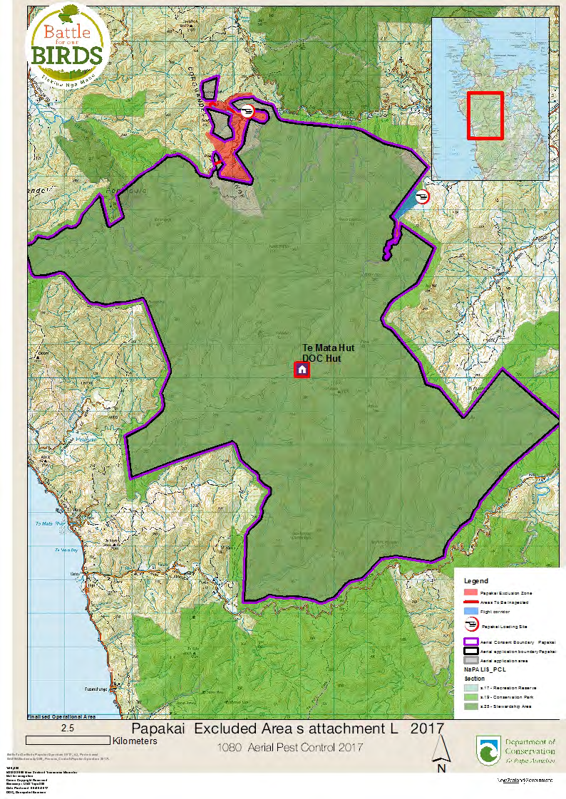
ATTACHMENT L: AREAS TO BE INSPECTED
The intent of this attachment is to identify places where the use of VTAs may directly or indirectly harm human
health.
ACT
List any other excluded areas not recorded elsewhere in the application (or identify on operational map,
Attachment A):
Flight corridors on the Mahakirau Road. The road way will be checked after the bait application.
The section of road at the end of the Mahakirau Estate will have bait applied over the road and the
road will be check and cleared of all baits.
In the event of a significant rain fall a number of waterways will be inspected on foot to ensure
carcasses have not been washed down and pose any danger. Refer to attachment L for more detail.
Describe the control methods for this area:
INFORMATION
No control methods will be employed in this area.
OFFICIAL
THE
UNDER
RELEASED
age 29 of 37
VTA permission application form - Version 3: March 2010
ACT
INFORMATION
OFFICIAL
THE
UNDER
RELEASED
age 30 of 37
VTA permission application form - Version 3: March 2010
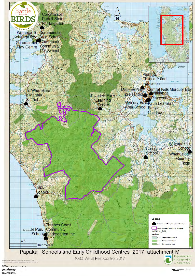
ATTACHMENT M: PRIMARY SCHOOLS, SECONDARY SCHOOLS,
KINDERGARTENS and OTHER EARLY CHILDHOOD CENTRES (ECCs)
(ECCs are facilities attended by pre-school children)
The intent of this attachment is to help to protect young children (and others who are unable to understand
notices) from the risk of contact with VTAs. For example young children walking or cycling to school may visit
friends, explore or take short cuts through operational areas (therefore their parents/caregivers need to receive
ACT
warnings of the whereabouts of VTAs in the area).
Explanatory Note - “Appropriate Distance”
This applies to the size of a circle around an operational area in which schools and early childhood centres
may be found. Urban schools are likely to have pupils coming from shorter distances than those in rural areas,
which have children coming from further afield. For example, a 2 km-radius circle area around an operational
area may be suitable in an urban setting, but a 10 km radius may be more suitable in a rural area. The
appropriate distance should be identified after consultation with school staff and with the delegated person. List all schools and early childhood centres located within an “appropriate distance” of the operational area:
School/ECC Distance from operational area
INFORMATION
Tapu School
3.5 km
Te Puru School
6 km
Te Wharekura o Manaia (Manaia)
4 km
Coromandel Area School
11 km
Mercury Bay Area School (Whitianga)
10 km
Coroglen School (primary)
4 km
Whenuakite School (primary) 11km
Kauri Leaners Early Childhood
10 km
Coromandel Rudolf Steiner Kindergarten
12 km
OFFICIAL
Coromandel Playcentre
12 km
Thames Coast Community Kindergarten Inc (Te Puru)
6 km
Coromandel Community preschool
12 km
Mercury Bay preschool (Whitianga)
10 km
Whitianga Playcentre
10 km
THE
Whenuakite Country Kids
13 km
Kapanga Te Kohanga Reo Coromandel 12 km
Peanuts Childcare and Education Whitianga 10 km
Riverlee Early Learning Centre 309 Rd Whitianga 1.5km
Central Kids Mercury Bay 10 km
UNDER
What schools and early childhood centres did you consult with in relation to this application?
Visited Riverlee Early learning Centre
Name the individuals or groups consulted:
As above
Detail what, if any, concerns these individuals/groups identified:
How are you planning to avoid, mitigate or remedy any adverse effects identified by these
individuals/groups?
RELEASED
Consultation fact sheets have sent additional information to Riverlee Early leaning Centre
Visited Riverlee to locate water supply and discuss 1080 in water supplies. Riverlee have requested that
their water be tested for 1080 for 3 months after the application of bait. Riverlee will take the samples and
DOC will cover cost of testing.
Attach any evidence of the consultation (correspondence, minutes of meetings, record of phone calls, etc):
See consultation plan
Provide a copy of the information that will be supplied to these schools and early childhood centres:
age 31 of 37
VTA permission application form - Version 3: March 2010
Attach: Copy of lists and information as requested above
(For official use)
ACT
INFORMATION
OFFICIAL
THE
UNDER
RELEASED
age 32 of 37
VTA permission application form - Version 3: March 2010
ACT
INFORMATION
OFFICIAL
THE
UNDER
RELEASED
age 33 of 37
VTA permission application form - Version 3: March 2010
ATTACHMENT N: NOTIFICATIONS
Notification is required to ensure that the general public is aware of any poisoning operation scheduled to take
place.
Hunting permissions for the general area of operation are required to carry a warning to hunters that poisoning
is planned for certain localities. The appropriate authorities (DoC, Regional Local Authorities or Unitary Local
Authorities, or Forest Managers) must be notified in advance of the operation to ensure that this happens.
Attach a copy of the information to be provided to groups and agencies.
ACT
A record or list of names/addresses of contacts is to be maintained by the applicant. This record is
to be kept
by the applicant for 12 months from the date of expiry of the Permission and shall be made available to the
delegated person on request.
Refer to attached communication record
Local health/medical services/police:
Police have been made well aware of the operation due to past and present anti activity, also they
have been made aware of the risk management plan for the operation. Are also looking at a security
INFORMATION
company to carry out loading site security
Medical centres: Refer to attached communication record
Veterinary clinics:
Refer to attached communication record
OFFICIAL
Hunting/kennel clubs/game packing houses, outdoor pursuits/clubs:
THE
Refer to attached communication record
Any other known groups that are likely to have access to the area:
UNDER
Refer to attached communication record
Attach: Copy of information to groups and agencies
RELEASED
(For official use)
age 34 of 37
VTA permission application form - Version 3: March 2010
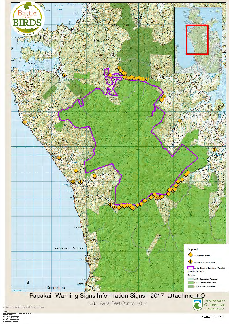
ATTACHMENT O: WARNING NOTICES, INFORMATION BOARDS,
PUBLIC INFORMATION CENTRES, KIOSKS etc
The intent of this attachment is to ensure that a clear warning is given to people of the presence and danger of
the VTA. Where foreign tourists frequently visit an area, it may be useful to provide signage in the appropriate
language. As a minimum, warning notices must be erected at every place where people normally obtain access
to the treatment area, including beaches and other landing points from waterways.
Explanatory Note: The term “regular” should be interpreted to suit local conditions. Where vandalism is to be
expected, notices will need to be checked daily. If vandalism is not expected in the operational area, longer
ACT
periods may be allowed to elapse between inspections.
List locations of warning notices and information boards (or identify on operational map; Attachment A):
Refer to map for location of warning signs, Information boards will located at each end of the 309
Road and the Tapu Coroglen Road, At the gate entrance into Mahakirua Estate, End of Goldfields
Road, Entrance into
, Entrance gate into
property Waikawau Valley
Road, Access Road into Te Mata Forest, End of public Road Mill creek Road, End of public Road
Kaimarama Road.Road will be checked ever second day for the first two weeks then weekly on a
Friday for the next 2 months and monthly after that.
INFORMATION
Attach: Copy of notices and information boards
OFFICIAL
(For official use)
THE
UNDER
RELEASED
age 35 of 37
VTA permission application form - Version 3: March 2010
ACT
INFORMATION
OFFICIAL
THE
UNDER
RELEASED
age 36 of 37
VTA permission application form - Version 3: March 2010
ACT
INFORMATION
OFFICIAL
THE
UNDER
age 37 of 37
RELEASED
Document Outline
- LOCAL PUBLIC HEALTH CONTACT
- ATTACHMENTS – A TO O
- Attach: Operational maps (2 copies):
- ( (For official use)
- ATTACHMENT B: Interested/ Affected Parties
- ATTACHMENT C: COMMUNITY CONSULTATION
- ATTACHMENT D: CONSULTATION WITH MAORI
- ATTACHMENT E: OPERATION DELIVERED BY SUBCONTRACTOR
- ATTACHMENT F: TRANSPORT, STORAGE and DISPOSAL OF VTAs
- ATTACHMENT G: DRINKING WATER SUPPLIES (Public and Private Water Supplies)
- ATTACHMENT H: DWELLINGS, ADJACENT LANDOWNERS/OCCUPIERS
- ATTACHMENT I: AREAS THAT ARE EASILY ACCESSIBLE
- ATTACHMENT J: TRAMPING HUTS, BIVVIES/SHELTERS, TENT CAMPING SITES, PICNIC AREAS, PUBLIC ROAD LAY-BYS and WATERCRAFT LANDING POINTS
- ATTACHMENT K: WALKING TRACKS and ROADS
- ATTACHMENT L: AREAS TO BE INSPECTED
- ATTACHMENT M: PRIMARY SCHOOLS, SECONDARY SCHOOLS, KINDERGARTENS and OTHER EARLY CHILDHOOD CENTRES (ECCs)
- (ECCs are facilities attended by pre-school children)
- ATTACHMENT N: NOTIFICATIONS
- ATTACHMENT O: WARNING NOTICES, INFORMATION BOARDS, PUBLIC INFORMATION CENTRES, KIOSKS etc