

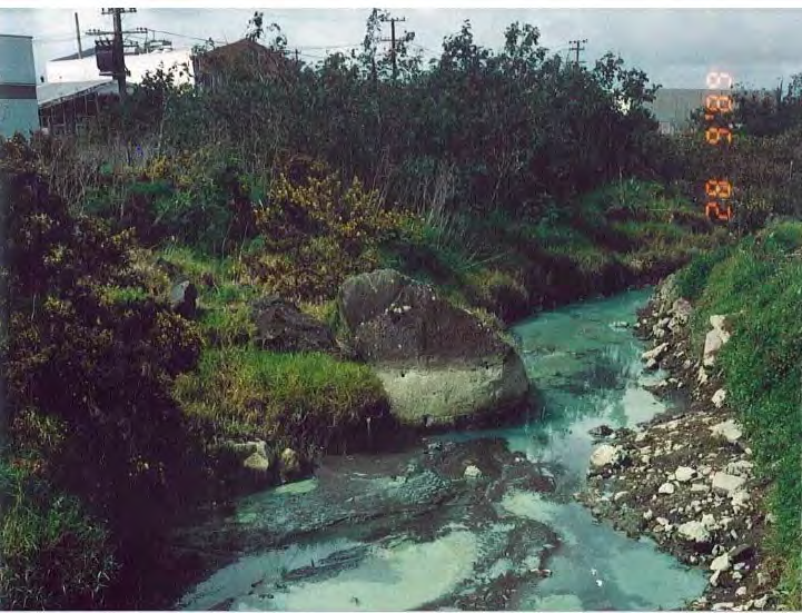
Attachment A
Photograph from Auckland Regional Authority File for the “Green Stream” Pollution Incident 1988 (URS,
2010)
THE ACT
UNDER
INFORMATION
RELEASED
NZ Transport Agency and
OFFICIAL
Auckland Transport
East West Connections Project:
Contaminated Land
Assessment to Support Option Selection
October 2014
Table of contents
1.
Introduction..................................................................................................................................... 1
1.1
Option A (Long List Option 1): Existing route upgrade. ....................................................... 1
1.2
Option B (Long list Option 2): Upgrade with South Eastern Highway Ramp. ...................... 2
1.3
Option C (Long List Option 5): Upgrade with new Galway Street and inland
connections. ................................................................................................................................... 2
1.4
Option D (Long List Option 8): Upgrade with Gloucester Park interchange and
new Galway Street and inland connections. .................................................................................. 3
1.5 Option E (Long List Option 13) New foreshore Connection................................................. 3
1.6
Option F (Long List Option 14) New foreshore and Inland Connection ............................... 3
2.
Methodology of the Assessment .................................................................................................... 5
3.
Background Information and Existing Environment ....................................................................... 6
3.1
References and Reliance .................................................................................................... 6
THE ACT
3.2
Existing Environment ........................................................................................................... 6
4.
Key Design Assumptions ............................................................................................................. 11
5.
Environmental Assessment.......................................................................................................... 11
5.1
Assessment of Option A .................................................................................................... 11
5.2
Assessment of Option B .................................................................................................... 11
5.3
Assessment of Option C .................................................................................................... 12
UNDER
5.4
Assessment of Option D .................................................................................................... 13
5.5
Assessment of Option E .................................................................................................... 13
5.6
Assessment of Option F..................................................................................................... 13
6.
Recommended Mitigation Required ............................................................................................. 14
INFORMATION
7.
Conclusion and Recommendation ............................................................................................... 14
8.
References ................................................................................................................................... 15
RELEASED
Figure index
Figure 1: Contaminated Sites ................................................................................................................... 7
OFFICIAL
GHD | Report for NZ Transport Agency and Auckland Transport - East West Connections Phase 111, 51/326513203/ | i
1.
Introduction
The East West Connections project is responding to the immediate and growing freight access
issues at either end of the Neilson Street/Church Street corridor caused by inefficient transport
connections and a lack of response to changes in the industry’s supply chain strategies. The
project is also addressing the inadequate quality of transport choices between Māngere,
Ōtāhuhu and Sylvia Park.
The long list of options was developed in a 2-stage process. The option identification process
began with identifying changes at a component level (e.g. lane widening; interchange
improvements) across the geographical area. To ensure a full spectrum of components was
considered, the study area was separated into segments. All components were then assessed
through a multi-criteria analysis. Where broadly equivalent components (in terms of either
transport performance or social, environmental or cultural outcomes) were identified, the best
alternative proceeded to the development of the long list options. If no broadly equivalent
alternative component existed, the component was progressed to the development of long list
options. All options were assessed through a multi-criteria analysis, which considered a full
THE ACT
range of impacts and performance against the project’s objectives and the East West
Connections outcomes. Six options were identified to progress to the short list for the
Onehunga-Penrose connection. These options range from low investment to high investment.
These 6 options are the subject of this assessment and a detailed description of each are held
in the Detail Business Case. The following summarised descriptions have been used as the
basis of the following assessment.
UNDER
1.1
Option A (Long List Option 1): Existing route upgrade.
This option looks to upgrade the existing roads. This includes improving capacity on
SH20, Neilson Street and Church Streets. It also provides freight lanes.
Auxiliary lanes / capacity improvements on SH20 (Queenstown Road to Gloucester Park)
INFORMATION
Some widening of Onehunga Harbour Road at Gloucester Park (e.g. around the
Onehunga Port area, beneath SH20 and potential to increase this from 2 to 3 lanes up to
Neilson Street / Onehunga Mall intersection).
Upgrading of the intersection at Onehunga Mall / Neilson Street intersection (potentially
RELEASED
including widening of bridge over the rail line) to provide for dedicated movements
between Onehunga Mall / Neilson Street.
Capacity improvements on Neilson St, for example extending the 4-laning from Alford St
to Church St (potential impact on some road frontages, but looking to minimise)
OFFICIAL
New signalised intersection to provide access to Metroport (for example, providing for
dedicated turning median).
Cycleway uses Hugo Johnston Road (within the road corridor), may impact on tree
planting etc in existing road reserve, will then connect to Church Street East and Great
South Road (level crossing) to connect to existing cycle path to Sylvia Park.
Freight lane priority at Mt Wellington Interchange where this can fit beneath existing
bridge constraints.
GHD | Report for NZ Transport Agency and Auckland Transport - East West Connections Phase 111, 51/326513203/ |
1
1.2
Option B (Long list Option 2): Upgrade with South Eastern
Highway Ramp.
This option proposes an upgrade of existing roads with new ramp connections from Church
Street to SH1 and South Eastern Highway.
Auxiliary lanes / capacity improvements on SH20 (Queenstown Road to Gloucester
Park).
Some widening of Onehunga Harbour Road at Gloucester Park is likely (e.g. around the
Onehunga Port area, beneath SH20 and potential to increase this from 2 to 3 lanes up to
Neilson Street / Onehunga Mall intersection.
At Onehunga Mall / Neilson Street intersection, upgrading of intersection is required
(potentially including widening of bridge over the rail line) to provide for dedicated
movements between Onehunga Mall / Neilson Street.
Looking at capacity improvements on Neilson St, for example extending the 4-laning from
Alford St to Church St (potential impact on some road frontages, but looking to minimise).
New signalised intersections and upgrades to intersections at Metroport (for example:
THE ACT
providing for a dedicated turning median), Church St, Hugo Johnston Drive and Great
South Road (grade separation at Hugo Johnston Drive and Great South Road may be
considered).
Cycleway using Hugo Johnston Road (within the road corridor), may impact on tree
planting etc in existing road reserve, will then connect to Church Street East and Great
South Road (level crossing) to connect to existing cycle path to Sylvia Park.
UNDER
New connections for ‘southern’ traffic on SH1, with ramps from the South Eastern Arterial
(looking at ramps of 2-lanes in each direction to connect from interchange to tie in with
SH1 at Mt Wellington). This requires an auxiliary lane extension on SH1 down to Princes
Street interchange.
1.3
Option C (Long List Option 5): Upgrade with new Galway
Street and inland connections.
INFORMATION
This option proposes a new connection from Onehunga Harbour Road to Galway Street, and
upgrade of Neilson and Angle Streets and Sylvia Park Road, and a new connection for Angle
Street to Sylvia Park Road and to SH1.
RELEASED
Auxiliary lanes / capacity improvements on SH20 (Queenstown Road to Gloucester Park)
Some widening of Onehunga Harbour Road at Gloucester Park is likely (e.g. around the
Onehunga Port area, beneath SH20.
OFFICIAL
New connection from Onehunga Harbour Road onto Galway Street (may impact on traffic
movements / access to SH20 from Onehunga Mall / Onehunga Harbour Road)
4-lanes on Galway Street with upgraded intersection to Neilson Street, upgrading of
intersection required (potentially including widening of bridge over the rail line) and to
address increased traffic from Onehunga Mall to Galway Street.
Looking at capacity improvements on Neilson St, for example extending the 4-laning from
Alford St to Angle St and upgrading of Angle Street (e.g. up to 4-lane, which may require
some additional land).
New connection from Angle Street to Great South Road for between 2 and 4 lanes, and
where practicable on land between Transpower towers and foreshore (not reclamation).
2 |
GHD | Report for NZ Transport Agency and Auckland Transport - East West Connections Phase 111, 51/326513203/
At Sylvia Park Road, increasing capacity of some of Sylvia Park Road (e.g. additional
lanes) and may require land take and relocation of Transpower towers.
Ramps over Mt Wellington Highway to connect onto SH1, serving the south, with
increased capacity (e.g. auxiliary lanes) on SH1 down to Princes St.
Waikaraka Cycleway maintained and extended alongside new road sections to connect to
Sylvia Park.
1.4
Option D (Long List Option 8): Upgrade with Gloucester Park
interchange and new Galway Street and inland connections.
This option proposes an upgrade at Gloucester Park Interchange and a new connection from
Onehunga Harbour Road to Galway Street. It also proposes an upgrade of Neilson and Angle
Streets and Sylvia Park Road, and a new connection for Angle Street to Sylvia Park Road and
to SH1. Auxiliary lanes / capacity improvements on SH20 (Queenstown Road to Gloucester
Park).
New interchange at SH20 at Gloucester Park, to restrict access to Neilson Street and
divert all traffic onto Onehunga Harbour Road (widening requirements for Onehunga
THE ACT
Harbour Road, e.g. 3+ lanes).
New connection from Onehunga Harbour Road onto Galway Street (may impact on traffic
movements / access to SH20 from Onehunga Mall / Onehunga Harbour Road).
4-lanes on Galway Street with upgraded intersection to Neilson Street, upgrading of
intersection required (potentially including widening of bridge over the rail line) and to
address increased traffic from Onehunga Mall to Galway Street.
UNDER
Looking at capacity improvements on Neilson St, for example extending the 4-laning from
Alford St to Angle St and upgrading of Angle Street (e.g. up to 4-lane, which may require
some additional land).
New connection from Angle Street to Great South Road for between 2 and 4 lanes, and
where practicable on land between Transpower towers and foreshore (not reclamation).
INFORMATION
At Sylvia Park Road, increasing capacity of some of Sylvia Park Road (e.g. additional
lanes) and may require land take and relocation of Transpower towers.
Ramps over Mt Wellington Highway to connect onto SH1, serving the south, with
increased capacity (e.g. auxiliary lanes) on SH1 down to Princes St.
RELEASED
Waikaraka Cycleway maintained and extended alongside new road sections to connect to
Sylvia Park.
1.5
Option E (Long List Option 13) New foreshore Connection
OFFICIAL
This option proposes a new connection from SH20 to SH1 along the foreshore.
Auxiliary lanes / capacity improvements on SH20 (Queenstown Road to Gloucester
Park).
New interchange at SH20 at Gloucester Park, with access to Neilson Street and onto
Onehunga Harbour Road (may require some changes to traffic movements from
Onehunga Harbour Road onto SH20).
New connection from Gloucester Park along foreshore to Captain Springs Road and then
inland to Great South Road.
GHD | Report for NZ Transport Agency and Auckland Transport - East West Connections Phase 111, 51/326513203/ |
3
New intersections at Captain Springs Road, Southdown (Metroport) and Great South
Road (may require relocation of Transpower towers).
At Sylvia Park Road, increasing capacity of some of Sylvia Park Road (e.g. additional
lanes) and may require land take and relocation of Transpower towers.
Ramps over Mt Wellington Highway to connect onto SH1, serving the south, with
increased capacity (e.g. auxiliary lanes) on SH1 down to Princes St.
Waikaraka Cycleway maintained and extended alongside new road sections to connect to
Sylvia Park.
1.6
Option F (Long List Option 14): New foreshore and inland
connection
This option proposes a new connection form SH20 to SH1 (partly along the foreshore and partly
inland).
Auxiliary lanes / capacity improvements on SH20 (Queenstown Road to Gloucester
Park).
New interchange at SH20 at Gloucester Park, with access to Neilson Street and onto
THE ACT
Onehunga Harbour Road (may require some changes to traffic movements from
Onehunga Harbour Road onto SH20).
New connection from Gloucester Park along foreshore to Captain Springs Road and then
inland to Great South Road.
New intersections at Captain Springs Road, Southdown (Metroport) and Great South
Road (may require relocation of Transpower towers).
UNDER
At Sylvia Park Road, increasing capacity of some of Sylvia Park Road (e.g. additional
lanes) and may require land take and relocation of Transpower towers.
Ramps over Mt Wellington Highway to connect onto SH1, serving the south, with
increased capacity (e.g. auxiliary lanes) on SH1 down to Princes St.
Waikaraka Cycleway maintained and extended alongside new road sections to connect to
INFORMATION
Sylvia Park.
RELEASED
OFFICIAL
4 |
GHD | Report for NZ Transport Agency and Auckland Transport - East West Connections Phase 111, 51/326513203/
2.
Methodology of the Assessment
This assessment of the six short-listed options was completed by:
conducting a walkover of the site area using publically accessible land
holding meetings with the Auckland Council closed landfill management team
reviewing historic aerial photographs from Auckland Council and the National Library to
provide context regarding activities in the study area, including reclamation and landfilling
along the Onehunga foreshore
collating readily available reports for contaminated sites in the study area, based upon
our knowledge of projects undertaken since the 1990’s and information held by key
organisations including Auckland Council and the Transport Agency
reviewing and summarising each technical report for the sites. All reports were shared
with the groundwater and geotechnical assessment specialists
plotting the physical boundaries of known landfill features on the spatial Project database
(Teamview) and representing these features and other known contaminated sites in
THE ACT
Figure 1
summarising the options in terms of potential effects on the environment related to
contaminated land (contaminated soil; groundwater; and gas). We have also commented
on contaminated sediments for the foreshore options.
The extensive study area encompassed by the six options precluded a full contaminated
land database search for all properties directly affected or adjacent to the alignments. The
UNDER
area comprises a highly industrialised zone with a documented history of heavy
industries, reclamation and waste disposal. As such, all alignments that pass adjacent to
current or historic industrial sites have been treated as likely to classify as Hazardous
Activities and Industries List (HAIL) category H (adjacent land) or category I (land subject
to intentional or accidental releases) pursuant to the National Environmental Standard for
Contaminated Soil (NES, 2011).
INFORMATION
Although a full contaminated site search of the Auckland Council database will reveal
more information regarding specific sites, many sites are expected to have little or no
environmental information and as such will need to be classified as “potentially
contaminated” on the basis of HAIL activities/landuse until proven otherwise. In
RELEASED
accordance with the NES, a preliminary site investigation (PSI) and detailed site
investigation (DSI) will need to be completed prior to construction of the preferred Option,
due to soil disturbance and the change in land use. An adequate level of characterisation
will also be required to support the resource consent applications.
OFFICIAL
GHD | Report for NZ Transport Agency and Auckland Transport - East West Connections Phase 111, 51/326513203/ |
5
3.
Background Information and Existing
Environment
3.1
References and Reliance
The references reviewed for this assessment are listed in Section 8.0.
A conceptual groundwater model for the study area has been prepared in the Groundwater
Assessment and has been relied upon for this assessment.
Effects of the Options on surface water and sediment quality are addressed separately in the
Ecology Assessment. The effects of the Options on groundwater flow are addressed in the
Groundwater Assessment, and we address effects on groundwater quality.
3.2
Existing Environment
The study area represents one of the most heavily industrialised parts of Auckland. The legacy
of contamination is widespread, and includes the industrial sites themselves; impacts from
THE ACT
discharges to soil, groundwater, air, stormwater and the coastal marine environment; and the
coastal reclamation sites that were used for landfills and uncontrolled filling. The former
Southdown freezing works site has been largely redeveloped although asbestos contamination
is prominent there and across the study area, partly due to waste materials derived from the
James Hardie manufacturing site in Penrose. The marine sediment quality in the area is
generally highly degraded, although at least the shallow sediment quality has been gradually
improving (as documented in the Ecology Assessment).
UNDER
The groundwater conceptual model presented in the Groundwater Assessment shows that the
groundwater and stormwater system is interconnected, and this affords the potential for
contaminants in groundwater to enter the reticulated stormwater system, as in the case of the
plume sourced from the former New Zealand Farmers Fertiliser site (
Figure 1) that links to
stormwater and the stream located near Miami Parade (URS, 2010).
Across the majority of the study area, seasonally saturated volcanic ash deposits (tuff) overlies
INFORMATION
the basalt flows that discharge south to the Onehunga Inlet. Further east, groundwater flows to
the east in the vicinity of the Mt Wellington SH1 interchange (based upon a URS environmental
investigation at the former Mazda site, now the Turners and Growers site). At that site (Figure 1)
the permeability of the tuff unit is low and acts as an aquiclude (barrier) overlying the basalt
RELEASED
aquifer, which inhibits vertical contaminant migration into the deeper groundwater. Stormwater
soak holes throughout the area provide a source of groundwater contaminants and influence
local groundwater levels. The permeability of the basalt aquifers is highly anisotropic (spatially
variable) and influenced by the degree and nature of fracturing.
OFFICIAL
Groundwater is used as a resource for a range of industrial purposes and by Watercare
Services Ltd for potable supply. Historically, springs were prevalent in the Onehunga area
although most have been intercepted by stormwater drains and the natural flow has been
disturbed by development and abstraction. Along the margin of the southern Onehunga
foreshore there is a leachate interception drain for the closed Pikes Point landfills, for which
Auckland Council is responsible.
6 |
GHD | Report for NZ Transport Agency and Auckland Transport - East West Connections Phase 111, 51/326513203/


beca.com
GIS@
11
10
9
14
8
12
7
3
5
1
6
4
THE ACT
13
2
15
Mangere Inlet
UNDER
1
Gloucester Park
INFORMATION
2
Reclaimed Land
3
Onehunga Borough council Landfil
4
Waikaraka Cemetery
5
Pikes Point West Landfil
6
Pikes Point East Landfil l
RELEASED
7
One Tree Hil Borough Landfil
8
NZR Landfil Area
9
Church Street Landfil
10
Former NZ Farmers Fertiliser Site
11
Mount Smart Landfil
OFFICIAL
12
Former Southdown Freezing Works
13
Former Westfield Freezing Works
14
Former Mazda Site
15
Former Tannery (Pengel y Site)
orkspaces\01_mxd\GIS-3818683-030_ContaminatedSites.mxd Author: BecaGIS Date: 20/10/2014
This map contains data derived in part or whol y from sources other than Beca, and
therefore, no representations or war anties are made by Beca as to the accuracy or
completeness of this information.
Map intended for distribution as a PDF document. Scale may be incor ect when printed.
Contains Crown Copyright Data. Crown Copyright Reserved.
Basemap source: Eagle Technology Group & LINZ.
File: P:\381\3818683\TGI\55_W
Revision
Author
Verified
Approved
Date
Client:
Title:
Discipline:
Map Scale @ A3: 1:25,000
NZ Transport Agency and
Auckland Transport
Figure 1
GIS
0
250
500
1,000
±
Project:
Potentially Contaminated Sites
Drawing No:
Metres
East West Connections
GIS-3818683-030
1
HEC
RJL
MGW
16/10/2014
A summary description for each of the known landfills in the study area is provided below.
These sites are found from west to east and their locations are illustrated in
Figure 1. The
boundaries of the sites shown in Figure 1 should be regarded as only approximate.
Galway Street Landfill
The Galway Street Landfill was historically known as the “75 Acre Reclamation” and was
operated by the Onehunga Borough Council (Earthtech 1993). The landfill covers an area of 30
ha that extends from the eastern side of Alfred Street / Waikaraka Park through to Onehunga
Mall in the west. It is bounded by Neilson Street and the Onehunga foreshore to the south.
The landfill was operated from some time after the Second World War (Earthtech 1993) through
to 1978 (T&T 2007). The Auckland Council 1986 aerial photograph show earthworks were
occurring on the site, which may include clean filling or capping of the landfill (Auckland Council
GIS website). The waste included domestic waste and commercial wastes and the filling
operations were uncontrolled (T&T 2007). After closure the landfill was capped with demolition
waste (Earthtech 1993). A rock bund forms the southern margin, with the bund height varying
from 2.5-3.5 m. The waste at the Alfred Street end of the bund extends above the bund by
approximately 2 m, with the refuse near surface. Other areas of the landfill are generally well
covered (ibid).
THE ACT
Investigations undertaken in 1994 by Tonkin & Taylor Ltd (T&T 1994) showed that the capping
layer was 0.3-2 m thick, followed by 4-5 m of moderately decomposed domestic waste, followed
by basalt (0.3 to 3 m thick) and East Coast Bays formation. The capping material was
reportedly 1-2 m thick on the western side and 0.2-0.3 m thick on the eastern side, comprising
gravelly silt.
The T&T (2007) assessment of soil contamination at the site subsequently developed for Visy
UNDER
Ltd as a recycling facility identified elevated concentrations of metals and “total petroleum
hydrocarbons” in soil, although concentrations were compliant with human health protection
criteria adopted for the planned industrial land use. Some soil Polycyclic Aromatic Hydrocarbon
(PAH) concentrations exceeded human health criteria. These investigations also measured
landfill gas. Methane concentrations ranged up to 41% by volume (v/v). Although flows
indicated that landfill gas production was relatively low, these methane levels correspond to an
INFORMATION
explosive / flammability risk. It is understood that the Visy building was subsequently
constructed with a vapour barrier in accordance with the T&T (2007) recommendations.
Church Street Closed Landfill
RELEASED
According to Earthtech (1993) a landfill was present in an area south of Church Street, near the
O’Rorke Road junction. Little information was available on this landfill, however, it is understood
that the filling occurred in a quarry that was owned by Stevensons.
Pikes Point West Reclamation and Closed Landfill
OFFICIAL
The Pikes Point West Landfill was established in 1973 and commenced with an earth filled rip-
rap sea wall that extended out approximately 250 m from the original coast line. A second sea
wall was constructed in 1974, and this extended 100 m further south of the original sea wall. No
purpose built leachate collection system was installed, however leachate was recovered from
the scoria filled annulus of a 1.8 m diameter stormwater pipe that passed through the landfill
(Earthtech 1993).
The land filling included both domestic and industrial wastes and continued through to late
1977. The fill depth varied between 1 – 9 m and leachate pumping was terminated in 1984
(Earthtech 1993). It is understood that the leachate interception system was subsequently
recommissioned and it is currently operational (Mark Crooks Auckland Council, pers comm).
8 |
GHD | Report for NZ Transport Agency and Auckland Transport - East West Connections Phase 111, 51/326513203/
As with Pikes Point East Closed Landfill (Babbage 2006), it is unlikely that Pikes Point West
Closed Landfill would be lined and as such it is presumed to be founded on marine sediments.
Pikes Point East Reclamation and Closed Landfill
Pikes Point was a peninsula that comprised the present day Miami Parade, Angle Street,
Pukemiro Street and Edinburgh Street. The Pikes Point East landfill was located immediately
east of Pikes Point. The landfill footprint is currently occupied by Green Vision Recycling, the
Heliport, and part of Metroport.
The construction of the landfill and reclamation commenced with the construction of the sea wall
including a leachate collection system and an impervious “clay cone” in 1977. The landfill was
founded directly on the marine sediments (Babbage 2006a). Landfilling operations continued
through to 1984. Earthtech (1993) reported that the landfill was capped with a 100-200 mm
layer of clay and scoriaceous tuff after 1984, leachate production was minimal and the recovery
system was abandoned in 1984.
In a letter to ARC, Babbage (2006b) reported that due to public pressure regarding leachate
discharges the leachate recovery system was recommissioned by Northern Disposal Systems
Ltd in the early 1990’s. It is understood that the leachate interception system remains
THE ACT
operational (Mark Crooks Auckland Council, pers comm).
Mt Smart Closed Landfill
Earthtech (1993) documented the former Mt Smart Landfill, located at the current location of Mt
Smart Regional Park / Mt Smart Stadium and bounded by Church Street to the south, Maurice
Road to the East, Rock Ridge Avenue to the North and O’Rorke Road to the West. They
reported that Mt Smart was a former basalt scoria cone that was quarried through to the 1960’s,
at which point backfilling of the pit commenced. The Mt Smart Landfill operated from the 1960’s
UNDER
through to May 1984. The landfill was used for the disposal of municipal refuse, industrial
waste, and towards site closure clean fill was used to complete reinstatement.
Former New Zealand Rail landfill
Earthtech (1993) reported that the former New Zealand Rail landfill lies in the piece of land that
is currently occupied by Metroport, and is situated between Neilsen Street and Hugo Johnston
INFORMATION
Drive, immediately north of the Pikes Point East Landfill. Refuse was reportedly placed at about
the same time as the Pikes Point East Landfill (1975 to 1984). The landfill also included clean
fill and hard fill especially in the northern portion of the site.
Former One Tree Hill Borough Council Tip Site
RELEASED
Earthtech (1993) identified this tip site within the southern portion of the NZ Rail property,
adjacent to the Pikes Point East landfill. The landfill operations are largely undocumented,
however based upon a review of historical aerial photos undertaken by Earthtech it is evident
that the landfill was operational in 1961 and 1975.
OFFICIAL
Asbestos Contamination
Woodward Clyde (1999) undertook investigations of asbestos in soil along the northern
Manukau Inlet foreshore in 1999. The investigations extended along the entire northern
foreshore of the Inlet and comprised a combination of test pitting and surface soil inspection.
The investigations did not visually identify asbestos in the foreshore through to the current
Heliport location (eastern extent of Pikes Point East landfill), however the asbestos was
identified at every location west of this area. The asbestos material identified included fibrolite,
asbestos cement pipes, “super 6” corrugated roofing, and white asbestos “filler”. This asbestos
material coincided with the presence of house hold and demolition waste material.
GHD | Report for NZ Transport Agency and Auckland Transport - East West Connections Phase 111, 51/326513203/ |
9
The report also identified that the Mighty River Power Southdown Co-Generation Facility (power
station) and Southdown Reserve, both located at the southern end of Hugo Johnstone Drive,
are sites with known asbestos contamination.
Gloucester Reserve
Gloucester Reserve comprises the former Hopua Tuff Ring that historically was tidally inundated
(von Hochstetter 1859). It is understood that this area was reclaimed using refuse and other
waste materials (Opus 2006).
Historic aerial photos available on Auckland Council GIS viewer shows that in 1940 Hopua Tuff
Ring had been reclaimed and appears to be used as a dirt racing track. The surrounding area
at that time was dominated by residential housing. The 1959 aerial photo still shows a dirt track
with surrounding residential land use, with some commercial / industrial land use commencing.
Subsequent developments represent a shift to commercial/industrial land use.
THE ACT
UNDER
INFORMATION
RELEASED
OFFICIAL
10 |
GHD | Report for NZ Transport Agency and Auckland Transport - East West Connections Phase 111, 51/326513203/
4.
Key Design Assumptions
Our assessment has adopted the alignments articulated in the Indicative Business Case EWC
Long List Summary, with the following key design amendments that have been adopted since
then:
Along the north shore of Mangere Inlet the proposed design of the foreshore options E
and F calls for an embankment approximately 60 metres wide to accommodate a four
lane road carriageway and a shared path and cycle way with swales for stormwater
treatment. The embankment is separate from the existing foreshore and as such it will
create area between the two that can be used for additional treatment and containment
of any leachate etc. The intended construction could include pre loading and in situ wick
drainage to reduce long term settlement and the finished road carriageway elevation will
be 4.5 m above mean sea level (amsl). It is anticipated that some ‘headland’ features
would be constructed to provide a more natural coastal edge. Existing drainage to the
Inlet will be provided for using culverts.
Option F has an inland alignment through the current MetroPort area.
THE ACT
We have assumed that the alignments that follow existing roads (including widening of
the road carriageway and intersection improvements) require only shallow (unsaturated
soil/rock) excavations.
The construction works for all terrestrial Options only require temporary dewatering, not
permanent groundwater dewatering.
5.
UNDER
Environmental Assessment
Our assessment of the effects of each Option on the environment in relation to contaminated
land is provided below.
5.1
Assessment of Option A
INFORMATION
The effects of Option A on the environment are relatively minor with regard to contaminated
land discharges because this Option utilises the existing road corridors. The Option proposed
will involve limited soil disturbance or effect upon groundwater. There is some potential that
shallow soil within the road corridor may be contaminated from adjacent HAIL sites, although
RELEASED
more likely the soil is impacted with lead and hydrocarbons (PAHs) from vehicle emissions and
any surplus spoil would require disposal to an appropriately licensed facility. The alignment
utilises roads that skirt the periphery of the Gloucester Reserve, Galway, Pikes Point West, NZ
Rail Fill Site, Mt Smart and Church Street landfills.
OFFICIAL
5.2
Assessment of Option B
The effects of Option B on the environment are relatively minor with regard to contaminated
land discharges because this Option utilises the existing road corridors and as proposed will
involve limited soil disturbance or effect upon groundwater. Compared to Option A, the risk of
encountering contaminated soil is somewhat higher because the proposed earthworks to widen
SH1 from SEART south to the crossing at Otahuhu Creek extends the corridor of the soil
disturbance to a range of additional industrial sites. Sediment in the vicinity of the SH1 Otahuhu
GHD | Report for NZ Transport Agency and Auckland Transport - East West Connections Phase 111, 51/326513203/ |
11
link to page 14
Creek bridge is contaminated by copper and chromium from a former tannery
1. The location of
the tannery site is shown in Figure 1.
There is some potential that shallow soil within the footprint of Option B may be contaminated
from adjacent HAIL sites, although more likely the soil is impacted with lead and hydrocarbons
(PAHs) from vehicle emissions and any surplus spoil would require disposal to an appropriately
licensed facility. The alignment utilises roads that skirt the periphery of the Gloucester Reserve,
Galway, Pikes Point West, Mt Smart and Church Street landfills and the NZ Rail Fill Site.
5.3
Assessment of Option C
The effects of Option C on the environment are potentially significant with regard to
contaminated land. The magnitude of effects primarily depends upon the method of construction
adopted for the sectors that cross landfills at MetroPort (Pikes Point East landfill and the NZ Rail
Fill Site) and at the new connection from Onehunga Harbour Road onto Galway Street where
the alignment adopts a route through the Galway Street landfill.
At the Gloucester interchange the alignment utilises roads that skirt the periphery of the
Gloucester Reserve, and along Neilson Street the alignment skirts the Pikes Point West landfill.
Further east the alignment also crosses areas around the former Southdown freezing works
THE ACT
including Southdown reserve and industrial sites where asbestos is prevalent in soil. At 36 and
38 Miami Parade, the alignment skirts to the south of the former Dominion Oil Refinery which
has a discharge to ground and groundwater. Other HAIL sites along the alignment at Angle
Street and Miami Parade include metal treatment enterprises, a demolition yard and a
hazardous chemical treatment facility. At SH1 the alignment intersects a partially remediated
HAIL site with chlorinated solvents in groundwater (the Former Mazda site, Figure 1).
UNDER
Construction across the landfills could comprise one of the following methods:
1.
Excavation of the refuse beneath the alignment prior to construction. Based on likely
depths to original harbour sediments, excavation may need to extend to 8 metres below
grade, although depths will be variable. This method would have the beneficial effect of
removing refuse to a secure disposal site. However, this method would effectively bisect
each landfill site, creating a barrier to shallow (landfill) groundwater migration with a
INFORMATION
permanent change to the drainage pattern of the landfill leachate. The landfill cap would
need to be reinstated to manage landfill gas and leachate generation properly.
2.
Development at-grade or on-embankment that relies upon ground improvement by
dynamic compaction or pre-loading. The primary effect of these techniques is upon
RELEASED
groundwater, because the compaction will cause transient discharges of contaminants
and a long-term reduction in the shallow aquifer (landfill) permeability that could cause
leachate breakouts upgradient from the alignment. Modelling these effects reliably would
be problematic. Similarly, the compaction would disturb the landfill gas equilibrium and
OFFICIAL
create unintentional gas migration.
3.
Construction on piles that extend to bedrock (either Waitemata series or basalt). This
method would require removal of contaminated soil and groundwater from within the pile
caissons for off-site disposal, thereby benefiting the environment in relation to those
materials. Depending upon the spacing of the piles, effects on groundwater flow may be
limited because flow between the piles will be uninterrupted. Therefore, effects on
groundwater quality could be managed to avoid leachate breakouts. Most of the refuse
volume in the landfill would remain undisturbed, which would also limit the effects on
1 Former Pengelly Transport site, 38 Luke Street Otahuhu; remediated c 2005 prior to redevelopment
as sports fields for Otahuhu Intermediate school
12 |
GHD | Report for NZ Transport Agency and Auckland Transport - East West Connections Phase 111, 51/326513203/
landfill gas. This construction technique is therefore most favourable in respect to
contaminated land effects.
5.4
Assessment of Option D
This Option is the same as for Option C, with additional works in the Gloucester Reserve to
provide the upgrade at Gloucester Park Interchange. The alignment across Gloucester reserve
introduces an increased risk of encountering landfill material in this area. Otherwise, the
assessment of contaminated land effects for Option D is the same as for Option C (including the
considerations regarding construction techniques through the landfills).
5.5
Assessment of Option E
The alignment of Option E has already been influenced by contaminated land considerations for
the foreshore component of the Option. The design response was to provide for a new
embankment separate from the existing foreshore, so that this Option does not impinge upon
the landfills and the existing leachate interception trench.
The effects of this Option on the environment are dominated by the extensive embankment in
the coastal marine area. The Ecology Assessment responds accordingly. In terms of
THE ACT
contaminated land, the positive effect of this Option is that the embankment will permanently
cap and contain the contaminated sediment
in situ.
Option E includes the Gloucester reserve considerations, and also extends across industrial
land to the east of Ann’s Creek. Most of the eastern industrial zone is relatively recent (post
1990’s) with the exception of the Westfield Freezing Works and Westfield Chemical Fertiliser
Works (Figure 1). Overall, the potential effects of this Option on the environment with respect to
UNDER
contaminated land are considered to be moderate.
5.6
Assessment of Option F
The alignment of the western sector of Option F has already been influenced by contaminated
land considerations for the foreshore component of the Option, which provided for a new
embankment separate from the existing foreshore to avoid the landfills and the existing leachate
INFORMATION
interception trench. However, the eastern sector crosses the Pikes point East landfill and NZ
Railways fill area. The alignment also encompasses Miami Parade and as such runs adjacent to
the HAIL sites in that area that are recorded above.
The potential effects of Option F are significant with regard to contaminated land.
RELEASED
OFFICIAL
GHD | Report for NZ Transport Agency and Auckland Transport - East West Connections Phase 111, 51/326513203/ |
13
6.
Recommended Mitigation Required
The design of Options that traverse the landfills should adopt a piled construction methodology.
Foreshore Options including Option F should be built on a separate embankment to avoid
effects on landfills.
7.
Conclusion and Recommendation
The Options range in scale in terms of complexity and intervention, and as such a range of
contaminated land effects is to be expected.
Landfills represent the major constraint for construction. They also pose the greatest
environmental risks. A piled design is preferred.
The majority of the land across the entire study area is potentially or actually contaminated,
based upon HAIL considerations. Further investigations will be needed to provide a full
assessment.
THE ACT
On the basis of existing information, the preferred Option should be selected on the basis of
network performance provided that the alignment either avoids known landfills or adopts a
construction method that minimises effects on the landfill(s).
The Options are ranked below in order of preference, in terms of potential effects related to
contaminated land:
Option A (ranking #1)
minor effects
UNDER
Option B (ranking #2)
minor effects
Option E (ranking #3)
moderate effects
Option F (ranking # 4)
potentially significant effects
Option C (ranking #5)
potentially significant effects
INFORMATION
Option D (ranking # 6)
potentially significant effects
RELEASED
OFFICIAL
14 |
GHD | Report for NZ Transport Agency and Auckland Transport - East West Connections Phase 111, 51/326513203/
8.
References
Babbage 2006a: Former Pikes Point East Landfill Site for Port of Auckland – Landowner and Affected Party Report.
October 2006, Ref 42131/1
Babbage 2006b: Letter to Auckland Regional Council, 21 December 2006. Pikes Point East Bond Store: Stormwater
Discharge Across ACC Reserve. Job ref 42131/1
Earthtech 1993: Groundwater Investigation Scoping Report. Pikes Point Aftercare, Auckland Regional Council.
Earthtech Consulting Ltd, 11 June 1993. Ref 2112.
NES 2011 Resource Management (National Environmental Standard for Assessing and Managing Contaminants in Soil
to Protect Human Health) Regulations 2011.
Opus 2006: SH20 Manukau Harbour Crossing Project – Assessment of Environmental Effects - Erosion and Sediment
Control Plan. Opus International Consultants Limited.
Tonkin & Taylor Ltd 1994: For the Auckland City Council, "Old Auckland Landfills (Report 3), Volumes 1 to 5".
THE ACT
September 1994, Report No. 11867.
Tonkin & Taylor, 2007: Materials Recycling Facility, Onehunga Auckland, Contamination Assessment.
URS 2010: Green Stream Contamination Plume Characterization and Risk Assessment. Report prepared for Auckland
Regional Council, 15 November 2010, Project reference 42112361.
von Hochstetter 1859: The Isthmus of Auckland with its Extinct Volcanoes. The drawing of geographical foundation
compiled principally from the Surveys of Stokes & Drury. In Hochstetter & Petermann Geological and Topographical
UNDER
Atlas of New Zealand.
Woodward Clyde, 1999: Manukau Foreshore Walkway- Asbestos Investigations. Report prepared for Auckland City
Council. Project ref AA24560083.00001
INFORMATION
RELEASED
OFFICIAL
GHD | Report for NZ Transport Agency and Auckland Transport - East West Connections Phase 111, 51/326513203/ |
15


THE ACT
UNDER
GHD
Level 3, 27 Napier Street
INFORMATION
Freemans Bay
T: 64 9 370 8000 F: 64 9 370 8001 E: [email address]
© GHD Limited 2014
RELEASED
This document is and shall remain the property of GHD. The document may only be used for the
purpose for which it was commissioned and in accordance with the Terms of Engagement for the
commission. Unauthorised use of this document in any form whatsoever is prohibited.
Document Status
OFFICIAL
Author
Reviewer
Approved for Issue
Name
Signature
Name
Signature
Date
Draft
Wijnand
Murray
3/10/2014 Udema
Wallis
section
3.2
Draft
Murray
Wijnand
3/10/2014 Wallis
Udema
(balance
of report)
Final
Murray
16/10/2014
Wallis

THE ACT
UNDER
www.ghd.com
INFORMATION
RELEASED
OFFICIAL
Document Outline