
File Ref: LCO.01
OIA Request 14-E-319
13 February 2015
Morgan Varaine
[FYI request #2293 email]
Dear Morgan
OFFICIAL INFORMATION REQUEST
I refer to your official information request of 7 December 2014 and again on 28
January 2015 for the following:
All Helicopter GPS Flight Path plans for the 1080 Drop in the Mt Aspiring National
Park and surrounding areas (Wanaka, Makarora, Hawea/Hawea Flat, Luggate,
Cardrona) during the "Battle for our Birds" operation.
In response to your request:
I regret that I am not able to provide you with the information you seek as there is no
such document as
“Helicopter GPS Flight Plans”. For this reason I am declining your
request under s 18 (e) of the Official Information Act 1992. GPS tracking only occurs
during and after the aircraft has flown an operation.
Therefore I am supplying you with the maps and material used in planning and
undertaking the aerial operations. This includes a planning map, flight path tracking
points and lines as well as briefing notes.
In summary:
1. There are two areas the Department is managing as part of the Battle for our
Birds, the Matukituki valley (operation completed) and the Makarora (planned)
(maps attached).
2. To undertake an aerial operation the Department:
a. provides a map of “the area to be treated” to potential operators (Matukituki
and Makarora maps attached) and also provides written material identifying
the conditions the operators must adhere to (both Matukituki and Makarora
“Request for Quotes” maps attached). The potential operators plan flight lines
and submit quotes based on this information. Additional information is
provided to operators as required e.g. consent conditions
b. prepares a specific helicopter pilot briefing. This is given just before the
operation, consistent with the latest map provided and GPS shape files
(Matukituki and Makarora maps attached), and
DOCDM-1550886 14-E-Morgan Varaine

c. undertakes post operation analysis of the flights both for
i.
where the machines flew on the operation when not delivering toxin
“secondary points” (Matukituki “secondary points” map attached) and
ii.
when spreading toxin “treated area” (Matukituki “flight line” map
attached).
3. TBfree NZ has also advised it has two aerial 1080 operations planned before the
end of May 2015 that may include areas of public conservation land. These are
Mount Roy and East Hawea. Maps are not yet available.
You are entitled to seek an investigation and review of my decision by writing to an
Ombudsman as provided by section 28(3) Official Information Act 1992.
Yours sincerely,
Carl McGuinness
Acting Deputy Director-General
Conservation Services
for Director-General
DOCDM-1550886 14-E-Morgan Varaine
 Maps and Attachments
Map 1 Matukituki “Area to be treated”
Map 2 Matukituki “Secondary points showing intervals of time where a helicopter has
flown when not sowing baits”.
Map 3 Matukituki “Treated Area” showing actual GPS flight lines flown when sowing
baits.
Attachment 1 Specific planning instructions for aircraft operators taken from DOC
“Request for Quotes” (Tender documents) for Matukituki Aerial 1080
Operation (Released 8-10-14)
Attachment 2 Pilot briefing for Matukituki Aerial 1080 Operation
Map 4 Makarora “Area to be treated”
Attachment 3 Specific planning instructions for aircraft operators taken from DOC
“Request for Quotes” (Tender documents) for Makarora Aerial 1080
Operation
(Released 8-10-14)
Attachment 4 DRAFT Pilot briefing for Makarora Aerial 1080 Operation
DOCDM-1550886 14-E-Morgan Varaine


Map 1 Matukituki “Area to be treated”
DOCDM-1550886 14-E-Morgan Varaine

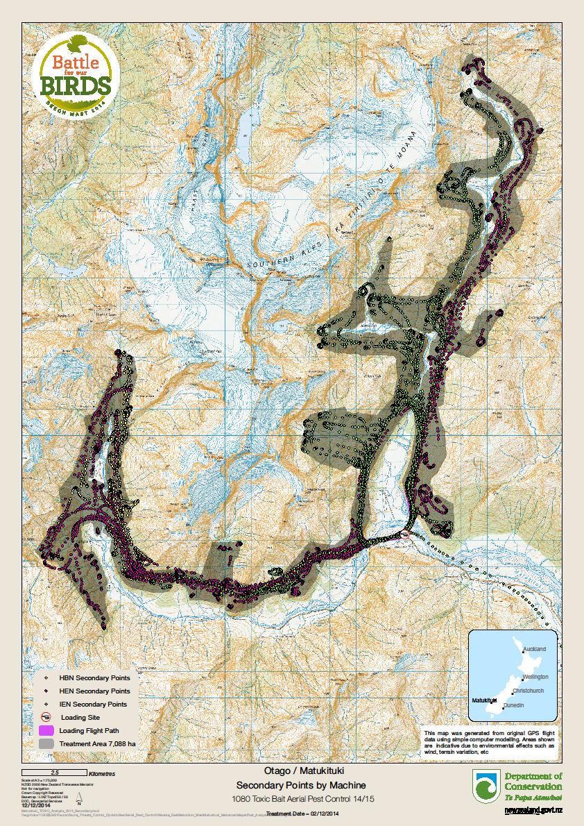
Map 2 Matukituki “Secondary points showing intervals of time where a helicopter has
flown when not sowing baits”
DOCDM-1550886 14-E-Morgan Varaine

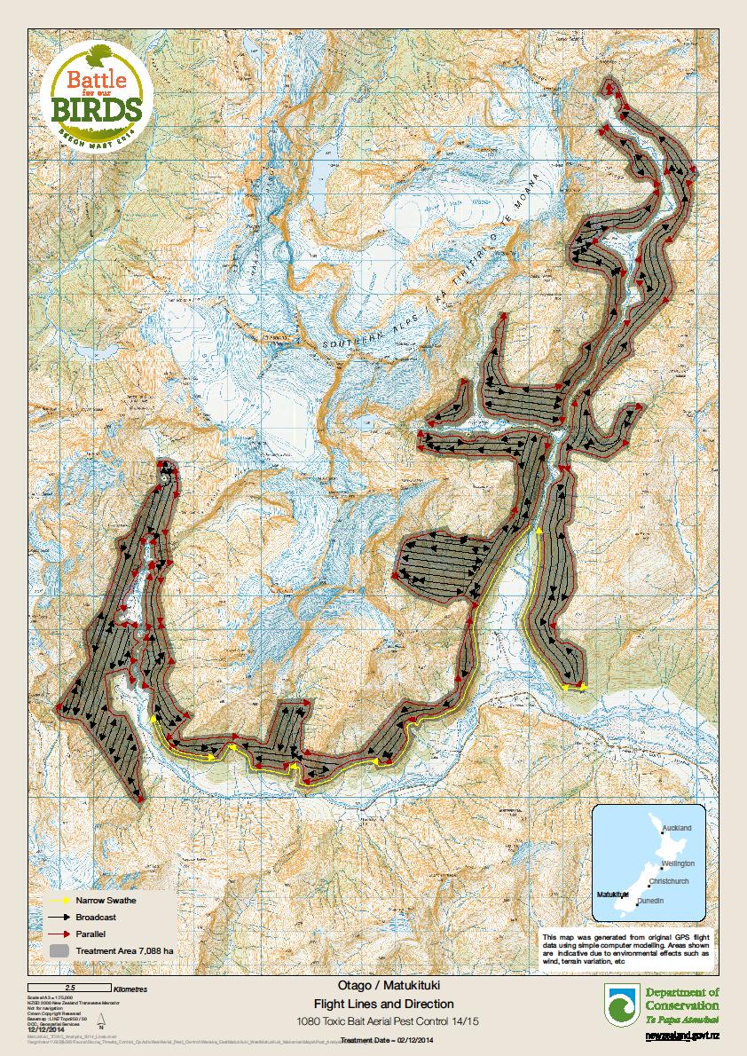
Map 3 Matukituki “Treated Area” showing actual GPS flight lines flown when sowing
baits.
DOCDM-1550886 14-E-Morgan Varaine
 Attachment 1 Specific planning instructions for aircraft operators taken from
DOC “Request for Quotes” (Tender documents) for Matukituki Aerial 1080
Operation
(Released 8/10/2014)
Matukituki:
Section 3.2 Goods/Service Requirements
Notes:
2) There are a number of sensitive boundaries involving private land, public
huts, water takes, State Highway 6, road lay-bys/ car parks and a
campground. These are buffered (typically 80m) and will show as voids
on the file.
3) All Huts and other voids are to be parallel sown.
4) The unfenced stock boundaries shown on the map are to be sown with a
narrow (<110m) swath. All other boundaries are to be sown parallel to the
treatment boundary using which ever swath width is suitable to achieve
the required coverage.
5) The remainder of the blocks can be sown as is best operationally that
meets the required coverage performance and sowing rate/ha.
6) MOH consent has not yet been received. The consent may require
increasing the voids around huts, water takes etc but this not expected.
7) All flight paths, including return flights are only to occur within the
Treatment Area or as approved in advance by the Supervisor eg crossing
rivers.
8) At no time are flights to occur over the State Highway.
10) The designated loading site is approximately 45km west of Wanaka at
Camerons Flat on private land.
Section 3.4 Financial and Output Reporting requirements, and Performance
Measures
GPS files are to be made available at each refuelling, and as otherwise
requested by the Site Supervisor.
DOCDM-1550886 14-E-Morgan Varaine


 Attachment 2 Pilot briefing for Matukituki Aerial 1080 Operation
Health & Safety
1. The H&S of the pilots and all crews is top priority for the day.
2. Pilots must follow the company H&S plan at all times. Pilots to make the final call on
weights of loads at all times.
3. John Keene is the Health & Safety Officer and Patrik will be the Load Site Supervisor.
4. Site Lay-out – Patrik will brief ground DOC and Contractor crews.
5. Heli contractor staff will be the only ones loading bags into the loader hopper.
6. Listen out for other aircraft in the Operational Area, as there may be tourist flights to and
aircraft concession activity within the treatment area, or passing aircraft traffic. Monitor
local channel.
7. For the avoidance of doubt the operator is responsible for all tasks associated with the
aerial distribution of the 1080 toxic bait, including
a. Filling the aircraft loading hopper
b. Loading area management
c. Cleaning up the loading area and equipment, including wash down of the loading
site and all equipment/vehicles/plant used on the loading site, including the bait
transport trucks. Note: In the event of an accidental spill on the loading site DOC
will be responsible for undertaking the clean-up of the bait.
d. Tracking and packaging (stowing) of used bait bags. Note: DOC will provide a
suitable ‘container’ to stow these bags and DOC wil remove from site.
e. Use of aircraft to apply 1080 toxic bait over the site.
f.
Provide an onsite co-ordinator to liaise with the DOC Operations Manager and
GIS specialist – Andy.
g. Contractor liaison person to notify Command unit (Flo) of Rego of helicopter,
weight of bait, and treatment block each load is going to.
8. Communications:
We have 1 sat phone on site in-case of emergency here at Cameron Flat.
Operations Manager will listen out on Fire channel 4 for Contractor Aircraft queries
The DOC ground crew will be using simplex (DOC channel 15 ) at Loading Site.
The staff transport helicopter will use DOC channel 15 when approaching staff to be
picked up.
DOCDM-1550886 14-E-Morgan Varaine
 Plan for the day
1. We are loading from Cameron Flat; this is private property, 45 km west of Wanaka on the
Mount Aspiring road.
2. Will be flying from this site all day.
3. All contractor aircraft will on leaving loading site give there rego, bait weight in bucket, bait
type, and site of treatment.
4. We will be sowing at 2kgs per hectare covering 7000ha of 12gram for the day.
5. Fly the treatment blocks as assigned for each machine and following the terms and
conditions of the contract. (variation)
6. Upper catchments will be flown first, then working down valley to complete the task
weather permitting.
Sensitive Areas
There is approx 17km of unfenced boundaries, where the treatment area boundary has been
moved away from potential stock movement into Public Conservation Land. To be sown with
a narrow (100m) parallel swath.
You must not fly over private property; when entering the Loading Site you must fly only within
the identified flight path area while going to and from the loading site.
All operational flying must only occur within the treatment area, not over the buffer/MOH or
RMA buffer.
No sowing within identified Voids. No flight tracks or turning over identified Voids.
All other flight paths, including return flights must occur within the treatment area, when
moving from one side of the valley to the other avoid to open river flat areas, only fly across at
the narrowest point.
Along this sensitive boundary there is two water takes. These are marked as OBHS and
Dunstan High voids.
Flight Paths
You must stay within the shown flight paths during departure and returning to the Loading
Site.
Water Intakes shown as Voids
• Aspiring Hut, Staff Quarters & Campsite (200m exclusion)
• Otago Boys High Lodge at MacPherson creek (Private) (200m) exclusion
• Dunstan High School Outdoor Centre, at Homestead creek. Private (200m) exclusion
Huts/Structures as Voids
West Matukituki Valley area
Liverpool Hut (80m exclusion)
Scotts Rock Bivouac (80 metre exclusion)
French Ridge Hut (80 metre exclusion)
Aspiring Hut (150 metre exclusion)
DOCDM-1550886 14-E-Morgan Varaine


Cascade Hut (private) (80 metre exclusion)
Geoff Wyatt Hut (Private) (80 metre exclusion)
Rob Roy Valley Viewing Point (80 metre exclusion)
East Matukituki Valley area
Rock of Ages Bivouac (80 metre exclusion)
Alpine Guides tent camps (2) (80 metre exclusion)
NOTE: ANY BAIT APPLIED WITHIN ANY IDENTIFIED EXCLUSION AREA (VOID) IS A
FAIL POINT; YOU MUST REPORT ANY ACCIDENTAL APPICATION OF BAIT INTO
THESE AREAS IMMEDIATELY. TELL US OF ANY ISSUES, PROBLEMS OR BREACHES
OF SOWING; THIS IS EXTREMELY IMPORTANT AS THIS IS TOXIC BAIT.
Walking Access Tracks
Downloading
1. All helicopters need to download data sticks after each flight.
Flight Paths
1. All flight paths over to only occur within the Treatment Area.
2. All flights to and from the loading zone need to be over the same track line and within the
approved flight path over private property.
Operational Matters
1. There maybe bait left over and if time permits we maybe able to sow any gaps.
2. Any issues with the sowing bucket ensure you fly within the boundary. Any landing must
only occur within the treatment area. Any landing for equipment problems can occur
within PCL open river flats within the treatment area but must be reported to Operations
Manager immediately.
3. Any spills need to be to be advised to Loading Site Supervisor and cleaned up
immediately. We can send people over if need be.
4. Please advise Operations Manager Paul Hondelink if you see any stock (cattle) within the
Treatment Area..
5. Heli pad will be set up away from loading site area for staff transport aircraft.
6. Please advise if there are any boundary issues or gaps where that have been missed, as
we may be able to sow these at the end of the day.
7. Estimated sowing time should be 6 to 7 hours for the 3 helicopters.
8. Any difference/order to sowing treatment blocks from our earlier discussions, please
advise Ops manager ASAP.
9. Any questions about the maps or loading site lay out.
DOCDM-1550886 14-E-Morgan Varaine
 Pilot Briefing / Sign-off Sheet
Pilot Name
Signature
1
2
3
4
5
Briefing given by: ____________________________ Date: ________________________
DOCDM-1550886 14-E-Morgan Varaine

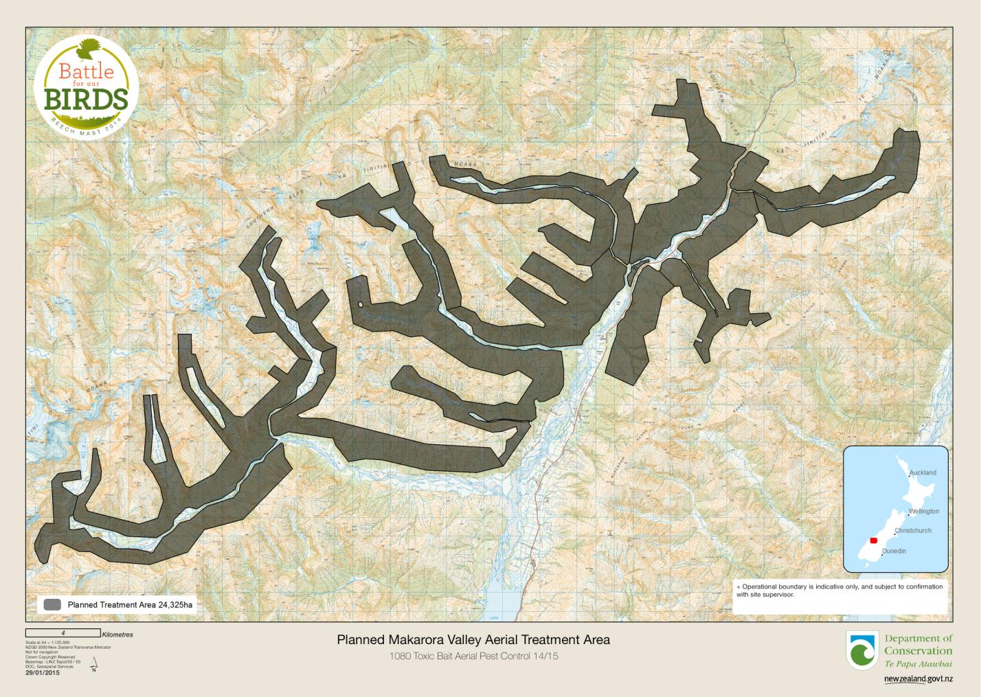
Map 4 Makarora “Area to be treated”
DOCDM-1550886 14-E-Morgan Varaine
Attachment 3 Specific planning instructions for aircraft operators taken from
DOC “Request for Quotes” (Tender documents) for Makarora
Aerial 1080 Operation (Released 8-10-14)
Section 3.2 Goods/Service Requirements
Notes:
2) There are a number of sensitive boundaries involving private land, public
huts, water takes, State Highway 6, road lay-bys/ car parks and a
campground. These are buffered (typically 80m) and will show as voids on
the file.
3) All Huts and other voids are to be parallel sown.
4) The unfenced stock boundaries shown on the map are to be sown with a
narrow (<110m) swath. All other boundaries are to be sown parallel to the
treatment boundary using which ever swath width is suitable to achieve the
required coverage.
5) The remainder of the blocks can be sown as is best operationally that meets
the required coverage performance and sowing rate/ha.
6) MOH consent has not yet been received. The consent may require increasing
the voids around huts, water takes etc but this not expected.
7) All flight paths, including return flights are only to occur within the Treatment
Area or as approved in advance by the Supervisor eg crossing rivers.
8) At no time are flights to occur over the State Highway.
11) The designated loading sites are approximately 5km north of Makarora West
and are located either side of the State Highway on Cameron Flat.
12) As part of ancillary flying, there is a requirement to transport between staff/
equipment to huts as far away as Top Forks and Siberia huts (approx 40mins
each way).
17)Two loading sites will be used, 1 either side of the State Highway (approx
1,000m apart).
3.4 Financial and Output Reporting requirements, and Performance Measures
GPS files are to be made available at each refuelling, and as otherwise
requested by the Site Supervisor.
21/1/2015 Update via email: - excerpt
Flight Corridors: Gillies Pass: Re the flight corridor below Gillespies Pass, the
more southern pass is approx 350m higher in altitude so we left as is.
Flightcorridor along Makarora River has disappeared [now shows as sections
between blocks] but all flightlines (including secondary) must remain inside the
Treatment Area.
Single loading zone shown: Not yet confirmed but Prefeed (at least) will fly from
this single loading zone.
Please quote from single loading zone only – if we can’t get permission we’l talk - but
that will be after the Prefeed has flown.
Waterway + Hut in Siberia is indicative at this stage – the water intake is currently
being moved/installed so accurate info is not yet available – highly likely that there
will not be space to fly between, so area removed.
 Airstrips:
 You’l notice 2 airstrips now appear on the map (Siberia and Wilkin). There
are some concessionaires with access to these strips who have confirmed bookings.
Unfortunately, it is currently a possibility that these airstrips may be in limited use on
an operational day. We will have access to their timetable and they (and yourselves)
wil be fully briefed on any potential ‘multi use’ of airspace. Attempts wil be made to
eliminate this risk but if this cannot be achieved, then mitigating the risk will be
highest priority.
27/1/2015 Update via email: Latest Makarora Map of Treatment Area provided to
operator Docdm-1549115
DOCDM-1550886 14-E-Morgan Varaine


Attachment 4 DRAFT Pilot briefing for Makarora Aerial 1080 Operation
Health & Safety
9. The H&S of the pilots and all crews is top priority for the day.
10. Pilots must follow the company H&S plan at all times. Pilots to make the final call on
weights of loads at all times.
11. Mark Mawhinney is the Health & Safety Officer and Jo MacPherson will be the Load Site
Supervisor.
12. Site Lay-out – Mark will brief DOC staff and Contractor crews of Load Site layout.
13. Heli staff will be the only people handling and loading bags into the loader hopper.
14. Listen out for other aircraft in the Operational Area, as there may be tourist flights to and
from the Siberia Valley via the Wilkin Valley. We may be able to obtain a schedule of
Concession Aircraft planned flights for the day. Aircraft concession activity could occur
within other valleys of the treatment area, or passing aircraft traffic through the Makarora
Valley to and from the West Coast. Monitor local aviation channels. Report your position
regularly.
Working in with the Aircraft Concession activity with flights in the Siberia Valley is
a high priority, not only for safety of all aircraft movements, but impacting on their
time table and inconvenience.
15. All flights across State Highway No 6, must stay within Flight corridor and maintain
maximum height at all times.
16. All staff be moved by Ancillary flying aircraft will require safety briefing.
17. For the avoidance of doubt the operator is responsible for all tasks associated with the
aerial distribution of prefeed and 1080 toxic bait, including
a. Filling the aircraft loading hopper
b. Loading area management
c. Cleaning up the loading area and equipment, including wash down of the loading
site and all equipment/vehicles/plant used on the loading site, including the bait
transport trucks. Note: In the event of an accidental spill on the loading site DOC
will be responsible for undertaking the clean-up of the bait.
d. Tracking and packaging (stowing) of used bait bags. Note: DOC will provide a
suitable ‘container’ to stow these bags and DOC wil remove from site.
e. Use of aircraft to apply prefeed and 1080 toxic bait over the site.
DOCDM-1550886 14-E-Morgan Varaine

f.
Provide an onsite co-ordinator to liaise with the DOC Site Supervisor. This
coordinator must pass on individual aircraft load weight, flight data, and treatment
block performance to the DOC Supervisor either leaving or returning to load site.
This will enable us to track current sowing rates and get track clearers moving.
18. Communications:
We have 1 sat phone on site in-case of emergency here at Cameron Flat.
Operations Manager will listen out on Fire channel 4 for Contractor Aircraft queries
Operations Manager is in corms with the Staging area at Makarora DOC Office via
radio (channel simplex 20)
The DOC ground crew will be using simplex (DOC channel 15) at Loading Site.
Plan for the day
7. We are loading from one loading site at Cameron Flat; this is approx 7km north of
Makarora town ship.
8. Prefeed operation is a dress rehearsal to the toxic operation.
9. Will be flying from this site all day.
10. Ancillary aircraft will be positioned from Back Country helicopter base.
11. We will be sowing at 1kg per hectare, 6 gram bait for the day, covering 24,325ha. (Approx
28 ton)
12. First fly and sow along all treatment blocks boundaries, this is a block with lots of narrow
fingers.
13. Fly the treatment blocks as assigned for each machine and following the terms and
conditions of the contract
14. Upper catchments will be flown first, then working down valley to complete the task
weather permitting.
15. Depending on Concession activity we will need to treat the area that lies within the Siberia
track to the Wilkin river, and get track walkers to clear track prior to any concession
activity.
Unfenced Boundaries.
There is approx 24km of unfenced boundaries, where the treatment area boundary has been
moved away from potential stock movement into Public Conservation Land. We must not fly
over private property; you must fly only in the treatment area and flight corridors while going
to and from the loading site.
Flight Corridors
You must stay within the shown flight paths during departure and returning to the Loading
Site.
Flight corridors have been provided between treatment blocks (across valley floors) and one
high crossing in the mid T/R of the Young Valley.
Water Intakes shown as Voids - upstream from intake.
Siberia Hut – 100m intake
Young Hut – 100m (stream)
Cameron Flat Camping Area – 150m intake
Mount Albert Station Homestead - 200m water intake, 100m building
DOCDM-1550886 14-E-Morgan Varaine

Dunks Hut – 100m (stream)
Cameron Hut (100 metre exclusion - stream)
Makarora Hut (100 metre exclusion - stream)
Haast Highway 6
Cameron Creek car park/track entrance (100m exclusion)
Cameron Flat camping area (150m exclusion)
Davis Flat rest area/Bridle track walking track entrance (80m exclusion)
Blue Pools car park (80m) and walking track (20m exclusion)
80m exclusion either side of highway
Bridge Flat 80m layby/carpark
Kiwi Flat 80m layby/carpark
Makarora River Bridge 80m layby/carpark
Lower Fish Bridge 80m layby/carpark
Haast Pass 80m layby/carpark
Structures
Young Valley area
Young Hut (100 metre exclusion)
Young Fork shelter/bivi (100 metre exclusion each)
Upper Makarora Valley
Makarora Hut (100 metre exclusion)
Cameron Valley
Cameron Hut (100 metre exclusion)
Wilkin Valley
Keiren Forks Hut (100 metre exclusion)
Siberia Hut (100 metre exclusion)
Top Forks Hut (100 metre exclusion)
Dunks Hut (100 metre exclusion)
Blue Pools Walking Track
20m exclusion either side of track
All other walking tracks within the treatment area will be sown
DOCDM-1550886 14-E-Morgan Varaine
 Application Rates
1. Makarora Valley treatment Area - 1kg of 6gram prefeed – 24,5 ton
Boundary Definition
1. There is no cut in boundary for this operation all boundaries are the maximum block
extent so you need to stop 60 m short. Fly to your lights.
2. Do the highest part of the block first if possible to try and avoid the cloud build up during
the day.
3. There are locations where the blocks get very narrow on the digital files. Please try to
sow these best you can.
4. MOH and RMA boundaries are not to be flown over, at all times. This will cause a
Emergency Response. Fly only in the treatment area and flight corridors.
5. Even if huts are outside the Treatment Area they will still have voids around then, do not
fly across these voids, they will trigger an Emergency Resonse.
6. Heli Otago to export flight data to us in NZTM format.
Operational Matters
10. There maybe bait left over and if time permits we maybe able to sow any gaps.
11. Any issues with the sowing bucket ensure you fly within the boundary. Any landing must
only occur within the treatment area. Any landing for equipment problems can occur
within PCL open river flats within the treatment area but must be reported to Operations
Manager immediately.
12. For the ground crews don’t engage the spinner when you are at the loading zone if there
is bait in the spinner. Any spills need to be to be advised to Loading Site Supervisor and
cleaned up immediately. We can send people over if need be.
13. Please advise Operations Manager Paul Hondelink if you see any stock (cattle) within the
Treatment Area, particularly along the Wilkin and Makarora Valley.
14. Ancillary Heli pad will be set up at Makarora. (Need to discuss with Harvey Hutton) prior
to operation commencing.
15. Please advise if there are any boundary issues or gaps where that have been missed, as
we may be able to sow these at the end of the day.
16. Estimated sowing time should be 6 to 7 hours for the 5 helicopters.
17. Any difference/order to sowing treatment blocks from our earlier discussions, please
advise Ops manager ASAP.
18. Any questions about the maps or loading site lay out.
19. NOTE: ANY BAIT APPLIED WITHIN ANY IDENTIFIED EXCLUSION AREA IS A FAIL
POINT; YOU MUST REPORT ANY ACCIDENTAL APPICATION OF BAIT INTO THESE
AREAS EMMEDIATELY.
Pilot Briefing / Sign-off Sheet
Pilot Name
Signature
1
2
DOCDM-1550886 14-E-Morgan Varaine

3
4
5
Briefing given by: ____________________________ Date: ________________________
DOCDM-1550886 14-E-Morgan Varaine