 Urban Development Area \ Appendix: Lincolnshire Farm Structure Plan
Operative: 04/05/2021
Lincolnshire Farm Structure Plan
Wellington City Council
Table of contents
1
INTRODUCTION
Urban Development Area \ Appendix: Lincolnshire Farm Structure Plan
Operative: 04/05/2021
Lincolnshire Farm Structure Plan
Wellington City Council
Table of contents
1
INTRODUCTION
1.1
OVERVIEW
1.2
APPLICATION OF STRUCTURE PLAN AND FURTHER INFORMATION
2
RESOURCE MANAGEMENT ISSUES
2.1
BACKGROUND
2.2
NORTHERN GROWTH MANAGEMENT FRAMEWORK
2.3
WELLINGTON REGIONAL STRATEGY (WRS)
2.4
REGIONAL TRANSPORT CONNECTIVITY
2.5
URBAN DEVELOPMENT STRATEGY
2.6
SITE ASSESSMENT
2.7
URBAN DESIGN
2.8
RESOURCE MANAGEMENT ISSUES
3
KEY PRINCIPLES
3.1
KEY PRINCIPLES OF THE STRUCTURE PLAN
Page 1 of 35
eplan.wellington.govt.nz
Urban Development Area \ Appendix: Lincolnshire Farm Structure Plan
Operative: 04/05/2021
4
PATTERN OF DEVELOPMENT
4.1
RESOURCE MANAGEMENT STRATEGY
4.2
AREAS OF PROTECTION
4.3
LIMITED DEVELOPMENT AREAS
4.4
DEVELOPMENT AREAS
5
MOVEMENT AND CONNECTIVITY
5.1
RESOURCE MANAGEMENT STRATEGY
5.2
MOVEMENT AND CONNECTIVITY
6
LANDUSE
6.1
RESOURCE MANAGEMENT STRATEGY
6.2
SPECIFIC LAND USE GUIDANCE
7
INFRASTRUCTURE
7.1
RESOURCE MANAGEMENT STRATEGY
7.2
SPECIFIC INFRASTRUCTURE PRINCIPLES AND REQUIREMENTS
8
STAGING
8.1
RESOURCE MANAGEMENT STRATEGY
8.2
STAGING PRINCIPLES AND REQUIREMENTS
9
IMPLEMENTATION AND OTHER METHODS
9.1
RESOURCE MANAGEMENT STRATEGY
9.2
URBAN DESIGN
9.3
PARTNERSHIP
9.4
DEVELOPMENT CONTRIBUTIONS
9.5
EMPLOYMENT AREA IMPLEMENTATION
9.6
INFRASTRUCTURE
9.7
LINK ROAD
APPENDIX 1:
SPECIFIC STAGE REQUIREMENTS
EMPLOYMENT AREAS: STAGES AND PRECURSORS
RESIDENTIAL AREAS: STAGES AND PRECURSORS
CLEAN FILL AREAS: STAGES AND PRECURSORS
APPENDIX 2:
WOODRIDGE SPECIAL RESIDENTIAL AREA DEVELOPMENT PRINCIPLES
Maps:
MAP 1: LOCATION MAP
MAP 2: CONTEXT MAP
MAP 3: PATTERN OF DEVELOPMENT
MAP 4: MOVEMENT
MAP 5: PUBLIC TRANSPORT
MAP 6: LANDUSE
MAP 7: MAJOR INFRASTRUCTURE
MAP 8: STAGING
*Note – All maps will be updated further to recommendations of the Hearings Committee upon completion of the plan change.
Page 2 of 35
eplan.wellington.govt.nz
Urban Development Area \ Appendix: Lincolnshire Farm Structure Plan
Operative: 04/05/2021
Part I: Issues
Page 3 of 35
eplan.wellington.govt.nz
Urban Development Area \ Appendix: Lincolnshire Farm Structure Plan
Operative: 04/05/2021
1.
Introduction
1.1
Overview
1.1.1
The structure plan
This document sets out a structure plan (the structure plan) for the development of an area generally referred to as Lincolnshire Farm as shown on Map
1
A structure plan is a series of maps and diagrams with supporting text to guide the development of a particular area by defining the pattern of
development and landuses, areas of open space, the layout and nature of infrastructure, and other key features to manage the effects of development.
Implementation of the structure plan provides an opportunity to realise the Council’s strategic vision and implement the principles of the Northern Growth
Management Framework (NGMF). This would be achieved through high-quality integrated urban development and protection of significant features in
accordance with the provisions set out in this structure plan.
1.1.2
The Site
Lincolnshire Farm is strategically located between State Highways 1 and 2, close to all three major Wellington urban centres of Porirua, Hutt Valley and
Wellington City.
The structure plan area is roughly the area bound by State Highway 1, Grenada North, Woodridge / Newlands and Horokiwi ridge. This approximately 400
hectare area is the largest remaining opportunity for greenfield development in Wellington City and one of largest and most strategically located in the
whole Wellington region.
1.1.3
Proposed development
The structure plan proposes that staged development of the site (over approximately a 10-15+ year period) will include:
• New road connections, as well as recreation and ecological links and protection
• A business area with local employment opportunities of around 45 hectares in size
• 800-900 new households in a variety of densities and styles
• A 4-lane link road from State Highway 1 between Tawa and Grenada interchange connecting to State Highway 2 between the Petone and Dowse
interchanges in the Hutt Valley
1.1.4
Development of the Structure Plan
The structure plan has been developed through a process of review, analysis and consultation with stakeholders. This has focused on:
• The vision and guidance for the site provided by the NGMF (see below)
• The strategic context of the development opportunities of the site in relation to the emerging Wellington Regional Strategy (WRS), the Urban
Development Strategy (UDS) and the Western Corridor Transport Study
• The site specific characteristics, opportunities and constraints
• Public consultation on the draft principles of the structure plan during May 2006
The structure plan will be implemented by way of a change to the District Plan as well as other interlinked actions by both the Council and other
stakeholders (see Section 9 below).
Further information on the resource management issues, background and development principles of the structure plan are contained in “Lincolnshire
Farm Structure Plan, Background Paper’ (the Background Paper), Wellington City Council, 2006.
1.2
Application of Structure Plan and further information
This structure plan relates directly to the site identified on the attached maps. It provides guidance to give effect to the Council’s Urban Development
Strategy, Environmental Strategy, and the Northern Growth Management Framework. It provides design assessment criteria for both subdivision and
landuse consent applications within this area and should be referred to in relation to development adjoining this area or impacting upon the
implementation of the structure plan.
This structure plan forms part of the Wellington City Council District Plan (the District Plan) and should be read in conjunction with all other applicable
sections of the District Plan. This includes:
• The Subdivision Design Guide in relation to the detail of subdivision consent applications
• The technical and engineering criteria relating to the implementation of development which are contained in the separate Code of Practice for Land
Development.
The structure plan relates directly to resource management issues for the Lincolnshire Farm area and introduces a new policy direction for this area. On
this basis this document is considered more applicable to the area than general provisions of the District Plan. As such, where conflict exists between the
District Plan and the provisions of this structure plan, the structure plan should generally be considered to take precedence.
Page 4 of 35
eplan.wellington.govt.nz
Urban Development Area \ Appendix: Lincolnshire Farm Structure Plan
Operative: 04/05/2021
2
Resource Management Issues
2.1
Background
This land has been identified for potential future urban development since the 1970’s. At this time the comprehensive development of the area between
Newlands and Takapu was planned for future urban growth as a series of interconnected neighbourhoods forming a larger development area.1
Of this area, only two major stages were developed – Grenada Village and Grenada North. As the remainder of the development, including the
supporting roading infrastructure, was not completed, these new areas remain poorly connected and relatively isolated (particularly in the case of
Grenada North).
The site was largely zoned for residential development until 1994, when as part of the development of the District Plan, all undeveloped land was ‘down
zoned’ and the site became Rural. This decision was appealed and as a result of this a notation was included in the District Plan that the site was
intended for future urban development.
1 Churton: Bridgetown: Grenada Development Report, Wellington City Corporation, 1976
2.2
Northern Growth Management Framework
The potential for development of the area was again considered as part of the detailed development of the NGMF in 2002 and 2003. At this time
principles were agreed and adopted as Council policy that the land should be developed for not only residential growth, but also to provide a new
employment centre for local people and the Wellington Region.
The development of the NGMF provided a strategic analysis of the appropriateness of development on the site, and outlined the potential form that such
development should take.
The core goal of the NGMF is the creation of a highly attractive, efficient, and accessible urban area in order to realise the vision of “…an integrated,
liveable, diverse, sustainable and prosperous community”.
To achieve this vision, the NGMF set in place a programme of actions, including the development of the Lincolnshire Farm area. The NGMF specifically
requires this to include a “major new employment centre” with a very high standard of design and accessibility with a focus on local employment to help
manage travel demand for growth in the northern suburbs.
The NGMF also sets out objectives, themes and values to guide development in order to achieve the vision (see Background Paper). These principles
have been applied to the structure plan to help realise this vision.
Ensuring a high quality of development which maximises the development opportunities of the site, while demonstrating best practice urban design and
implementation of the principles of the NGMF have been key issues addressed by the structure plan.
2.3
Wellington Regional Strategy (WRS)
The WRS provides economic and regional land use development strategy for the region. In order to support the implementation of the WRS, the
structure plan will need to manage development of the employment land in order to help maximise regional benefit.
Key issues addressed by the structure plan therefore include:
• The phasing of development in order to support the implementation of the WRS
• Ensuring both the quality of development and that this is employment focused
• The need to use a variety of tools outside of the structure plan to support the successful development of the employment area
2.4
Regional Transport Connectivity
In April 2006 Greater Wellington approved a draft Regional Transport Programme which includes construction of a new link road between SH1 and
Dowse Interchange by 2014/15.
A key issue for the structure plan is to make provision for a link road that is designed:
• to accommodate at least 25,000 VPD
• to allow high average vehicle speeds (70-80km/hr)
• to have a minimum number of intersections to maintain traffic speeds
• to provide connections to the structure plan area
A further implication is that due to the potential for demand by a substantial volume of traffic, care needs to be applied to ensure that the staging of
development does not result in a substandard road connection being made available from SH1 to the Hutt Valley – including any connection via Horokiwi
Road, which is incapable of safely servicing such volumes.
2.5
Urban Development Strategy
To ensure that future growth and change occurring within Wellington reinforces the physical and spatial characteristics that make the city so distinctive
and contribute to the stimulating and intense urban experience it offers, the Council has developed an Urban Development Strategy (UDS).
The key solution sought by the UDS is for ‘A growth management strategy that directs growth to where the benefits are greatest, where the adverse
effects are minimised, and delivers on quality’. As such, the UDS directs that the majority of growth and urban development in Wellington will occur in the
central area and along the area identified as the ‘growth spine’.
As a supporting strand of this core strategy, the UDS recognises and provides for limited greenfield growth in the NGMF area and in particular the
development of the new employment centre at Lincolnshire Farm as well the potential link road from Grenada to the Hutt Valley.
Page 5 of 35
eplan.wellington.govt.nz
Urban Development Area \ Appendix: Lincolnshire Farm Structure Plan
Operative: 04/05/2021
A key issue addressed by the structure plan is therefore the need to be consistent with the strategic direction and guiding principles of this strategy by
ensuring that the quality of development supports the implementation of the overall UDS.
2.6
Site Assessment
The location and area of the structure plan is shown on Map 1.
A full description and assessment of the site and its surrounding context is contained in the Background Paper. This assessment has been carefully
considered and factored into the development of the structure plan.
From the assessment, key site constraints, opportunities and issues are shown on Map 2.
2.7
Urban Design
Key urban design issues for the creation of the structure plan to create a successful, attractive and vibrant urban environment include the following:
Legibility: through the creation of a sense of place, identifiable through clear links, nodes, landmarks and edges
Variety: through the creation of a mixture of uses within the development area, including a range of opportunities and choices for work, for living and for
social interaction
Permeability: through a variety of choices for movement between high quality, sustainable, interesting and identifiable spaces
Vitality: through a mixture of uses surrounding the central neighbourhood centre area
Design that supports and encourages public transport provision, walking and cycling
High quality design and layout of buildings in key areas such as adjacent to public spaces, the neighbourhood centre and the employment area
Design that enhances public safety and reduces opportunity for crime and anti-social behaviour through application of “Crime Prevention Through
Design” (CPTED) principles
Design that respects and relates to the ecological, landscape and contextual qualities of the site.
2.8
Resource Management Issues
Within the context outlined above, the following are considered the key resource management issues related to a structure plan for the Lincolnshire Farm
area:
• In line with the NGMF, development of the land should achieve the following:
o A high quality of development based upon the principles of best practice urban design to create an integrated, liveable, diverse, sustainable and
prosperous community
o A highly attractive, efficient and accessible urban area
o Protection and linkage of significant landscape, ecological and natural features of the site
o Inclusion of a major new employment centre design to provide local and regional employment opportunities. Such a centre should be of a high quality
design with a variety of building a lot sizes, with no ‘big box’ retail
o Inclusion of a neighbourhood centre to provide facilities for local residents and workers
o Inclusion of a variety of housing and lifestyle choices to meet the needs of a cross section of the community
• Phasing of development needs to be managed in order to ensure that necessary infrastructure is put in place to support the development and
connections are made between the surrounding communities
• The staging and quality of development of the employment centre should be managed in order to support the implementation of the Wellington
Regional Strategy
• The structure plan and development must be designed and staged to support the implementation of the Urban Development Strategy
• The structure plan must include provision for a link road running from State Highway 1 / Grenada to State Highway 2 / Hutt Valley
• The structure plan must relate to the site specific characteristics and contextual form and location of the site
• The structure plan must promote and facilitate development based upon the principles of good urban design
• Protection of high voltage transmission line corridors
Page 6 of 35
eplan.wellington.govt.nz
Urban Development Area \ Appendix: Lincolnshire Farm Structure Plan
Operative: 04/05/2021
Part II: Structure Plan
Page 7 of 35
eplan.wellington.govt.nz
Urban Development Area \ Appendix: Lincolnshire Farm Structure Plan
Operative: 04/05/2021
3
Key Principles
3.1
Key Principles of the Structure Plan
From the resource management issues above the following are identified as being the key Principles for the structure plan:
KP1: Quality of development. Development opportunities of the site should be maximised where possible to create a compact urban
form, while demonstrating best practice urban design and implementation of the principles of the Northern Growth Management
Framework. Development of the structure plan area should create a highly attractive, efficient and accessible urban area while
protecting and linking the significant landscape, ecological and natural features of the site.
KP2: Mixture of uses. Ensure that development includes range of opportunities and choices for work, for living and for social
interaction. This must include a major new employment centre which has no ‘big box’ retail, an accessible and well designed
Principles
neighbourhood centre, local parks and reserves and a range of housing types.
KP3: Phasing of development and implementation of infrastructure. These aspects need to be managed in order to support the
implementation of the Urban Development Strategy, Wellington Regional Strategy and ensure that necessary infrastructure is put in
place to support the social and economic development of the structure plan area.
KP4: Connectivity. Ensure legible and accessible connections are made through the site to link local communities, the region through
the State Highway 1 to State Highway 2 link road, and ecological and recreational areas.
Results
The structure plan area will be developed in a way which creates an integrated, liveable, diverse, sustainable and prosperous
anticipated community. These key Principles provide the overarching goals of the structure plan. All development proposals should first be
and
considered in relation to these and then to the specific Principles and Requirements set out below in order to assess whether the vision
explanation of the structure plan is being put into practice.
Page 8 of 35
eplan.wellington.govt.nz
Urban Development Area \ Appendix: Lincolnshire Farm Structure Plan
Operative: 04/05/2021
4
Pattern of Development
4.1
Resource Management Strategy
The structure plan area is a complex physical environment situated in the middle of four existing communities. The pattern of development is largely
dictated by the constraints of the topography and ecological values of the site as well as opportunities to connect with and strengthen existing
communities.
Through assessment of the qualities, location and context of each area of land, a pattern of potential development can be established which will help to
ensure that development fits well within the environmental and contextual qualities of the site, while providing opportunities to create a well connected and
vibrant central area.
As shown on Map 3, three broad areas are identified:
• Areas of Protection: which are not considered suitable for development and will generally become Council owned reserves
• Limited Development Areas: where limited development could occur provided that this does not compromise the existing values of the land
• Development Areas: where development should be encouraged and concentrated
It is noted that the boundaries of these areas are approximate only and will be determined through the consideration of specific
development proposals and reference to types of land use as set out below.
4.2
Areas of Protection
Principle
APP1: Protect, retain and enhance the landscape, ecological or recreational values of Areas of Protection.
APR1: The landscape, ecological or recreational values of Areas of Protection should be retained and protected from inappropriate
or unnecessary development which compromises these values. APR2: Development in Areas of Protection should be limited to the
Requirements provision of necessary infrastructure (such as sewerage, transport connections and tracks). Such infrastructure should be designed
and located in order to not unduly compromise the values of these areas.
These areas will provide a green corridor through the structure plan area which retains and protects the significant environmental
Results
values of the area and provides for a variety of recreational activities. Areas of Protection are generally considered unsuitable for
anticipated
development due to their landscape, ecological or recreational values. These areas combine to form a network open space through
and
the structure plan area. Due to the size and location of these areas, there will be a requirement to construct some infrastructure
explanation
such as tracks, roads, sewerage lines and reservoirs through these areas. Where this occurs, this should be designed in a way to
minimise disturbance to these areas.
4.3
Limited Development Areas
LDP1: Allow for well designed, low intensity, generally rural residential type development provided that this does not compromise the
Principle
landscape, landform or ecological values of Limited Development Areas or the integrity of the national Grid.
LDR1: Development in Limited Development Areas, including earthworks, vegetation clearance and construction should be
sensitively designed in order to not compromise the landscape, landform and ecological values of the site.
LDR2: Development should be at a low level of intensity to ensure that the environmental qualities of the land are not dominated by
Requirements built structures or modifications as a result of development.
LDR3: All earthworks and vegetation clearance should be limited to that necessary to create suitable access and building sites.
Removal of significant or primary bush remnants should be avoided.
The environmental qualities of these areas will be retained and enhanced, linking to and supporting the values of Areas of
Results
Protection while allowing for appropriate low intensity development. Limited Development Areas contain a range of qualities which
anticipated
should be retained and protected from inappropriate development which could compromise these values. Combined with the Areas
and
of Protection they help form the sense of space through the structure plan area. These areas contain a range of qualities which
explanation
should generally be retained and protected from inappropriate development which could compromise these values.
4.4
Development Areas
DAP1: Concentrate the majority of development within Development Areas with a graduated increase in intensity of landuse towards
Principle
an identifiable centre.
DAR1: Where possible, the environmental qualities of the land should be retained in Development Areas.
Requirements DAR2: Higher density development should occur towards the centre of Development Areas with the intensity decreasing towards the
periphery.
The vast majority of development in the structure plan area will occur within the identified Development Areas thereby helping to
Results
protect more sensitive or less appropriate areas from development. Development Areas have been identified as being more suitable
anticipated
for development due to their landscape, topographical, ecological and locational characteristics. In order to support a walkable,
and
compact, vibrant and high quality central area, which can link with public transport routes, the intensity of development should be
explanation
concentrated towards the centre of the main Development Area.
Page 9 of 35
eplan.wellington.govt.nz
Urban Development Area \ Appendix: Lincolnshire Farm Structure Plan
Operative: 04/05/2021
5
Movement and Connectivity
5.1
Resource Management Strategy
A well connected place will be a successful place. Improved connectivity offers choice, supports a variety of land uses and helps to strengthen links within
and between communities.
Safe and attractive urban environments also rely on good connections to offer a variety of choices for movement between places. If good conditions are
provided for pedestrians, this will also encourage more movement and create opportunities for interaction and recreation in the street environment.
Good linkages should therefore be made through the structure plan area to existing communities and within the new development which occurs. Where
possible, such links should be anchored by identifiable spaces. Quality spaces will encourage people to interrupt their journey in order to rest, enjoy the
space and interact with others.
The movement network within the structure plan area will be made up by roads (with provision for walking, cycling, private vehicles and public transport)
and dedicated pedestrian / cycle links. These should interlink to create a safe, accessible and legible network which encourages sustainable forms of
transport.
A hierarchy and network of road links is required by the structure plan, linking to the pattern of development. An indicative layout of these links is shown
on Map 4.
It is noted that with detailed design, the exact location of these roads is likely to alter. Indicative public transport routes and the 400m walkable catchment of these are shown on Map 5.
The key roads include the following:
• Link road / Arterial – providing regional connectivity between State Highway 1 / Grenada and State Highway 2 / Hutt Valley. At present principal access
to the structure plan area is via the Grenada exit of State Highway 1. This interchange may require upgrade if it were to provide the main point of access
to and from the completed Link road. The alternate preferred option to this is the construction of a new link from SH1 approximately 400m south of the
existing Tawa interchange to the Link road as shown on Map 4. The Link road will be a limited access road meaning that there will be no direct property
access onto or off the road in the structure plan area (including to the Employment Area). Access will instead be provided from the Major Intersections
identified.
• Avenue / Principal Road – This is the ‘main street’ providing the backbone of the movement network in the structure plan area including the main public
transport routes. This would connect directly onto the Link Road and also connect with the extended Woodridge Drive. The design and layout of this road
will alter through the structure plan area to reflect how it integrates with and supports the adjacent landuses.
• Collector network – providing the key connections within the structure plan area and to the surrounding communities.
• Key local roads – providing secondary connection within the structure plan area and to the surrounding communities. These connections include links
Horokiwi via Horokiwi Road and / or Hillcroft Road. Due to the nature of lower Horokiwi Road and its connection to State Highway 2, it is not suitable for
any significant additional traffic and through access to this road would need to be tightly controlled (see staging requirements of stages RA13, RA16 and
RA17 in Appendix 1).
• Track network – providing secondary pedestrian / cycle and recreational links through the Areas of Protection
• Track / road connections – identified locations where the local roading system will need to provide connection and frontage to the track and reserves
network
5.2
Movement and Connectivity
MCP1: Ensure that identified road connections are appropriately designed, provided for and constructed as part of the development
of the structure plan area to create a well connected and legible place.
Principles
MCP2: Create a movement network which supports and encourages sustainable forms of transport – in particular walking, cycling
and public transport.
MCP3: Create a track network linking from the urban areas and road network through the open space areas.
MCR1: The design of all development, including subdivision and landuse must incorporate provision for and not compromise the
identified road or track connections.
MCR2: Road connections should be appropriately designed to reflect their status in the roading hierarchy and to facilitate a safe,
accessable and sustainable movement network.
Requirements MCR3: The Avenue / Principal Road should be designed to provide a main street environment with a high level of pedestrian
amenity and public transport provision.
MCR4: Roads should where possible provide safe and legible connection and frontage to reserves and the track network.
MCR5: No through road access should be constructed to Horokiwi Road unless the Link Road is constructed or alternative or
improved access onto State Highway 2 has been constructed.
Development will result in the construction of a movement system which provides a high level of connectivity and legibility. The
roading network forms an essential part of the movement network within the structure plan area. It is vital that as the development is
Results
staged, the future roading network is considered and provided for so that the ability to construct future connections is not
anticipated
compromised. This includes ensuring that roads are vested and constructed to the boundary of development areas. The road
and
network is fundamental to sustainable forms of movement including walking, cycling and public transport. As such it needs to link to,
explanation
and provide access to, the track system and the reserves and open space areas. The potential public transport routes through the
structure plan area are shown on Map 5.
Page 10 of 35
eplan.wellington.govt.nz
Urban Development Area \ Appendix: Lincolnshire Farm Structure Plan
Operative: 04/05/2021
6
Landuse
6.1
Resource Management Strategy
Appropriate land uses within the structure plan area have been determined with reference to the pattern of development and movement network
identified above. This will both locate land uses to the areas most suitable for the activities that will occur, and will support a compact urban form which will
support sustainable modes of transport.
As shown on Map 6, eight types of land use have been identified from the pattern of development.
It is noted that the boundaries of these areas are
approximate only and will be determined through the consideration of specific development proposals and the final location of roads
which generally provide separation between landuses.
6.1.1
Areas of Protection
· Reserve 1: due to the significant environmental qualities of this land, and the opportunities it can offer for recreation, landscape protection or
ecological enhancement, it will be protected by becoming the reserves network through the structure plan area, owned and managed by the Council.
6.1.2
Limited Development Areas
· Rural Residential Area: These areas are considered suitable for low intensity rural residential development provided such development does not
compromise the landscape, landform or ecological values of the site. Any subdivision or development proposals in these areas will therefore need to be
supported by detailed landscape and ecological assessments and measures required to avoid, remedy or mitigate the impacts of development –
including the location and design of roads, driveways and buildings. On this basis, no minimum lot size is required, with the pattern of subdivision and
development instead required to fit the environmental qualities of the land and provide sufficient space for onsite sewage and stormwater disposal. This
also provides for the possibility of land being held in communal ownership arrangements.
6.1.3
Development Areas
• Reserve 2: These areas are central public open spaces which will be developed in order to provide high quality amenity space for recreation and social
activity and will be owned and managed by the Council. They are centrally located adjoining the neighbourhood centre to ensure that they are highly
accessible to as many people as possible – both residents and workers. Requirements are set to ensure the quality of design of surrounding landuses
which are essential to ensure the safety and quality of the spaces.
• Residential 1: These areas are considered most suitable for general housing. A range of densities, styles and sizes of houses is encouraged to meet
the needs of the wider community.
• Residential 2: This area is situated in close proximity to the Neighbourhood Centre and to public transport routes and other amenities. As such it is
considered more suitable for a higher density residential development. Requirements guide density and the mixture of housing types to encourage a
range of housing stock to meet the needs of a cross section of the community.
• Neighbourhood Centre: This is the heart of the structure plan area. It will provide the location for local shops (serving both local residents and workers),
a place to meet and community facilities. Requirements are set to ensure the quality of urban design and suitability of landuses.
• Employment: There are two employment areas. These areas are considered the most suitable locations for employment uses due to their good
transport access, position in the movement network and unsuitability for residential development due to the location of the Link Road and State Highway
1. Requirements are set to ensure the quality of urban design and suitability of landuses. In Employment Area 2, any retail activity over 500m² GFA will
be managed to assess the impact on the vitality and viability of surrounding town centres (particularly Tawa, Johnsonville and Newlands).
• Clean Fill Site: One major site for clean fill has been identified. This area adjoins the existing Grenada North sports fields which were created from clean
fill. Development of the structure plan area is likely to result in a surplus fill from earthworks and this site has been selected as a suitable location for this
spoil. Long term, it is intended that the clean fill site could be developed as an extension of the existing sports fields. This will require that the clean fill site
is managed and filled in such a way to ensure long term stability and suitable drainage. Additional Clean Fill sites may be identified through the
development process and the relevant principles and requirements set out below will apply to these also.
• Community facilities including schools have not been identified as specific development areas but there is the potential for such uses to be established
on appropriate sites in most of the land use areas. The designation of sites for new public schools is a responsibility of the Ministry of Education and will
follow the relevant procedures under the Resource Management Act 1991.
6.2
Specific Land use Guidance
The Principles and Requirements set out below provide specific guidance on the development of each of the land use areas.
Refer to Section 1.2 above for guidance on the general application of the structure plan.
6.2.1
Reserve 1
RS1P1: Protect and enhance the environmental qualities of this land as a public reserve for landscape, ecological or recreation
Principle
purposes.
RS1R1: The landscape, ecological or recreational values of Reserve 1 areas should be retained and protected from inappropriate
or unnecessary development which compromises these values.
Requirements RS1R2: Development in Reserve areas should be limited to the provision of necessary infrastructure (such as sewerage, transport
connections and tracks). Such infrastructure should be designed and located in order to not unduly compromise the values of these
areas. For developments in the Woodridge Special Residential Area refer to Appendix 2.
Page 11 of 35
eplan.wellington.govt.nz
Urban Development Area \ Appendix: Lincolnshire Farm Structure Plan
Operative: 04/05/2021
The Reserve 1 areas will provide a publicly owned network of open space through the structure plan area which links to the Outer
Results
Greenbelt, retaining and protecting the significant environmental values of the area. Reserve 1 areas are generally considered
anticipated
unsuitable for development due to their landscape, ecological or recreational values. Due to the size and location of these areas,
and
there will be a requirement to construct some infrastructure such as tracks, roads, sewerage lines and reservoirs through the area,
explanation
however the impacts of such works shall be minimised.
6.2.2
Reserve 2
RS2P1: Development of high quality centrally located public open spaces providing amenity space for recreation and social
Principle
activities.
RS2R1: Reserve 2 areas should be centrally located, adjoining the Neighbourhood Centre, well connected to pedestrian and cycle
links and fronted by roads to provide public access and passive surveillance.
Requirements RS2R2: Development of sites adjoining Reserve 2 areas should be designed in order to enhance the amenity values of these
spaces and provide passive surveillance.
Results
High quality attractive urban open space areas which provide for a variety of active and passive recreational activities. Reserve 2
anticipated
areas are areas of public open space which are managed for recreation and social activities. They are centrally located adjoining
and
the neighbourhood centre to ensure that they are highly accessible to as many people as possible – both residents and workers.
explanation
6.2.3
Rural Residential
RRP1: Allow for well designed, low intensity, generally rural-residential type development provided that this does not compromise the
Principle
landscape, landform or ecological values of this area.
RRR1: Subdivision and development proposals will be assessed in relation to the Rural Area Design Guide.
RRR2: Development in Rural Residential areas, including earthworks, vegetation clearance and construction shall be sensitively
designed in order to avoid, remedy or mitigate effects on the environmental qualities of the land.
RRR3: Development should be at a low level of intensity and sustainably designed to ensure that the environmental qualities of the
land are not dominated by buildings or the impacts of earthworks.
Requirements RRR4: All earthworks and vegetation clearance should be limited to that necessary to create suitable access and building sites.
Removal of significant or primary bush remnants should be avoided.
RRR5: Any subdivision or development proposals shall generally include methods such as building design (height, cladding,
location, construction methodology) landscaping, habitat enhancement, consent notices or covenants to avoid, remedy or mitigate
the impacts of development to ensure the environmental qualities of the land are protected or enhanced on an ongoing basis.
The environmental qualities of these areas will be retained and enhanced, linking to and supporting the values of Reserve 1 areas
Results
while allowing for appropriate low intensity development. Rural Residential areas generally form a buffer between Areas of Protection
anticipated
and Development Areas. These areas contain a range of qualities which should be retained and protected from inappropriate
and
development which could compromise these values. Combined with the Areas of Protection they help form the open space network
explanation
through the structure plan area.
6.2.4
Residential 1
Principle
R1P1: Ensure well designed, well connected residential areas which offer a range of living choices.
R1R1: Subdivision of Residential 1 areas shall provide for a variety of lot sizes in order to facilitate a variety of housing types and
sizes.
Requirements R1R2: Subdivision and development proposals in the Residential 1 area shall provide for the passive surveillance of adjoining
Reserve 1 and Reserve 2 areas. For developments in the Woodridge Special Residential Area refer to Appendix 2.
Results
Through compliance with the pattern of development set by the structure plan, attractive, compact and accessible residential areas
anticipated
will be developed. Guidance on the development of residential areas – location, links, proximity to other activities, layout and design
and
is generally contained in other sections of the structure plan and through the relevant provisions of the District Plan.
explanation
6.2.5
Residential 2
R2P1: Ensure well designed, well connected residential areas which offer a range of living choices at a medium density of
Principle
development within generally multi-unit development.
R2P1: Subdivision of the Residential 2 area shall be designed to provide for future medium density residential development,
including multi-unit housing developments.
R2P2: Subdivision and development proposals in the Residential 2 area shall provide a minimum density of 25 household units per
Requirements hectare of gross land area.
R2P3: Multi-unit housing developments in the Residential 2 area shall include a range of housing sizes and types.
R2P4: Subdivision and development proposals in the Residential 2 area shall provide for the passive surveillance of adjoining
Reserve 1 and Reserve 2 areas.
Results
An area of medium density residential development, incorporating a range of living choices will be created within easy walking
anticipated
distance of local amenities including shops, parks, public transport routes and community facilities. Guidance on the development of
and
residential areas – location, links, proximity to other activities, layout and design is generally contained in other sections of the
explanation
structure plan and through the relevant provisions of the District Plan.
6.2.6
Neighbourhood Centre
NCP1: Ensure a well designed, compact and well connected neighbourhood centre with a high level of amenity which provides
Principle
amenities and facilities to serve the needs of local residents and workers.
Page 12 of 35
eplan.wellington.govt.nz
Urban Development Area \ Appendix: Lincolnshire Farm Structure Plan
Operative: 04/05/2021
NCR1: Development of the Neighbourhood Centre shall be in accordance with an approved detailed development plan for the whole
area in order to achieve the Principle for this area. Matters which will need to be included in the development plan include the
matters listed below:
• Layout and scale of buildings: these should generally be of two to three stories in height providing a strong and active relationship
to the street
• Location of carparking and streets: No off-street car parking should be located at the front of buildings adjoining the Avenue or the
extension of Woodridge Drive. Car parking should be provided either on-street, or at the rear of buildings where possible
• Relationship to the Reserve 1 and Reserve 2 areas: Development should present an active edge and strong connection with the
Reserve 1 and Reserve 2 areas in order to provide passive surveillance and sense of ownership. The neighbourhood centre should
be separated from the Reserve 1 and Reserve 2 area by way of a local road which is significantly traffic calmed
• Creation of active frontages: onto the Avenue / Principal Road and the extension of Woodridge Drive through the use of a fine
grain of tenancies / activities, doorways and glazed facades
Requirements • Public transport: provision needs to be made for the location of public transport routes and waiting areas, as the Neighbourhood
Centre will provide the hub for public transport
• The quality of public space: including footpaths and roads, places to meet, landscaping, sunlight and wind protection
• Relationship to surrounding residential development
• Mixture of uses: these shall generally be commercial / community facilities on the ground floor and residential or commercial on
upper floors. Residential access should be provided from the rear of development as opposed to from the Avenue or Woodridge
Drive extension
• The design of commercial tenancies shall include a variety of sizes in order to provide a finer grain of development to allow for a
mixture of smaller business rather than the centre being dominated by singular large retail / commercial activities
• Concept plan for infrastructure provision, including the location of any major infrastructure requirements and the management of
stormwater flows and quality
• Any residential development should be on upper floors only
The creation of a high quality, popular, commercially successful and attractive neighbourhood centre which provides a focal point for
Results
the local community.
anticipated
The Requirements above provide guidance as to what is appropriate on this site in order to address the resource management
and
issues identified and achieve the Principles of the structure plan. These will need to be addressed through the development of a
explanation
detailed development plan for the area.
6.2.7
Employment Area 1
EMR1: Development of each stage of the Employment Area shall be in accordance with an approved detailed development plan for
the phase in order to achieve the Principle for this land use area. Matters which will need to be included in the development plan
include the matters listed below:
• General layout and scale of buildings: these should generally be a maximum of 15m in height providing a strong relationship to the
street. Building coverage should not exceed 70% of each site
• Street layout: provision will need to be made for access by trucks, and should also provide for rear servicing of development
fronting the Avenue / Principal road, walking and cycling
• Location of carparking and servicing: No off-street car parking should be located at the front of buildings adjoining the Avenue. On
all sites car parking should be provided either on-street, or at the rear or side of buildings where possible
• Scale of development sites: Development should be at a graduated scale and intensity with smaller, finer grained development
adjoining the Avenue and larger development sites away from more sensitive landuse areas
• The Avenue / Principal road: Development fronting the Avenue opposite the Reserve 2 and Neighbourhood Centre areas should
Requirements present an active frontage to the street with servicing to occur from the rear of the buildings
• Front façade: All development sites should present a well designed, attractive frontage to the street
• The quality of public space: including footpaths and roads and places to meet within the Employment area
• Landscaping: the development of sites not fronting onto the Avenue shall include details of how these will be landscaped in order
to present an attractive frontage to the street
• Concept plan for infrastructure provision, including the location of any major infrastructure requirements and the management of
stormwater flows and quality
EMR2: All land use within the Employment Areas shall be of an employment / manufacturing / distribution focus.
• Any residential development should be on upper floors and linked to the employment uses located on the site.
• Any retail activity on any site shall be ancillary to the principal activity of the site. The principal activity of any site shall not be retail,
including bulk retail activity.
• No industries with noxious, offensive discharges or contaminants including odour, air pollution, waste water or hazardous
substances shall be established in the area
Results
Development of a vibrant, attractive and successful place to work and do business. While other parts of the District Plan provide
anticipated
general guidance on the scale, intensity and type of landuse appropriate for this area, the Principle and Requirements above
and
provide more detailed guidance as to what is appropriate in this area in order to address the resource management issues identified
explanation
and achieve the Principles of the structure plan.
6.2.7.A
Employment Area 2
Principle
1 Ensure a well designed compact and well connected employment area with a high level of amenity for commercial uses.
1: Development of each stage of Employment Area 2 shall be in accordance with an approved detailed development plan for the
phase in order to achieve the Principle for this land use area. Matters which will need to be included in the development plan include
the matters listed below:
General layout and scale of buildings: these may be to a maximum of 15m in height providing a strong relationship to the street.
Building coverage should not exceed 70% of each site
No buildings shall be located generally within 20m of the boundary with the motorway (SH1)
Street layout: provision will need to be made for access by trucks, and should also provide for rear servicing of development
fronting the Avenue / Principal road, walking and cycling
Location of carparking and servicing: No off-street car parking should be located at the front of buildings adjoining the Avenue. On
Page 13 of 35
eplan.wellington.govt.nz
Urban Development Area \ Appendix: Lincolnshire Farm Structure Plan
Operative: 04/05/2021
all sites car parking should be provided either on-street, or at the rear or side of buildings where possible
Scale of development sites: Development should be at a graduated scale and intensity with smaller, finer grained development
adjoining the Avenue and larger development sites away from more sensitive landuse areas
Requirements
Front façade: All development sites should present a well designed, attractive frontage to the street
The quality of public space: including footpaths and roads and places to meet within the Employment area
Landscaping: the development of sites not fronting onto the Avenue shall include details of how these will be landscaped in order
to present an attractive frontage to the street
Concept plan for infrastructure provision, including the location of any major infrastructure requirements and the management of
stormwater flows and quality
2: All land use within Employment Area 2 shall be of an employment / manufacturing / distribution or supporting retail focus.
Any residential development should be on upper floors and linked to the employment uses located on the site.
No industries with noxious, offensive discharges or contaminants including odour, air pollution, waste water or hazardous
substances shall be established in the area
3: Landscaping including the planting of trees of sufficient density and height shall be undertaken between any development and the
motorway to mitigate the visual effects of proposed building(s) when viewed from the motorway (including the motorway overbridge)
Results
Development of a vibrant, attractive and successful place to work and do business. While other parts of the District Plan provide
anticipated
general guidance on the scale, intensity and type of landuse appropriate for this area, the Principle and Requirements above
and
provide more detailed guidance as to what is appropriate in this area in order to address the resource management issues identified
explanation
and achieve the Principles of the structure plan.
6.2.8
Clean Fill
CFP1: Provide for a well managed spaces where clean fill from the development of the structure plan area can be placed in order to
Principle
provide for a future recreation or development areas
CFR1: Prior to any fill being located on a Clean Fill site, a detailed development plan will need to be approved in order to achieve
the Principle for this land use area. Matters which will need to be included in the development plan include the matters listed below:
Quantity and quality of fill
Area of fill
Requirements
Management and operation of the activity
Noise, dust, sediment and stormwater management
Traffic management and routes for trucks
Remediation of the site
Well managed clean fill sites where the effects of the operation are adequately avoided, remedied or mitigated. On the identified
Results
Clean Fill site a new recreation area will be established. The Clean Fill area identified in the structure plan adjoins the existing
anticipated
Grenada North sports fields which were created from clean fill. Development of the structure plan area is likely to result in a surplus
and
fill from earthworks and this site has been selected as a suitable location for this spoil. Long term, it is intended that the clean fill site
explanation
be developed as an extension of the existing sports fields. Additional Clean Fill sites may be identified through the development
process and the relevant principles and requirements will apply to these also.
Page 14 of 35
eplan.wellington.govt.nz
Urban Development Area \ Appendix: Lincolnshire Farm Structure Plan
Operative: 04/05/2021
7
Infrastructure
7.1
Resource Management Strategy
Infrastructure provides the necessary services required for development to occur such as power, road access and sewerage disposal. As shown on Map
7, the structure plan area will largely be serviced by infrastructure connections from the west and south of the site. This will direct the phasing of
development, with infrastructure put in place in earlier stages servicing the subsequent stages of the structure plan.
Allowance for the future development of the entire structure plan area should therefore be made in the location and design of infrastructure. Detail of the
design of key infrastructure components is set out in the Council’s Code of Practice for Land Development.
The key infrastructure requirements of the structure plan area are as follows:
• Electricity: There are no known capacity issues in relation to the supply of electricity to the site, although there may be specific requirements in relation
to local transformers and substations.
• Gas: There is currently no gas network in the area. Provision of a network system of gas will be at the discretion of the developer
• Telecommunications: While there are local telecommunications exchanges which can be connected to, there is no local cable or fibre optic network.
Such a system will be required as part of the development of the structure plan although how this connects to a wider network will need to be negotiated
between the developer and telecommunications suppliers.
• Sewerage: Connection can be made to the existing Council sewerage system which runs through Glenside and Tawa to the treatment plant in Porirua
which is jointly operated with Porirua City. While there may be existing actual capacity within the plant to accommodate the development of the whole
structure plan area, depending on the demands of other development in the catchment area of the plant, upgrade works to this treatment plant over the
development life of the whole structure plan area may be required. Such works may require a review of current development contributions to pay for this
work.
• Stormwater: The principal means of stormwater disposal from the structure plan area will be the Belmont Stream. As such the management of the quality
of stormwater and control of flows are key considerations for development.
o Quality: General principles for stormwater management are set by the Subdivision Design Guide with specific design guidance set by the Code of
Practice for Land Development. This guidance, combined with the Requirements below, will encourage sustainable forms of stormwater management are
utilised where possible as opposed to ‘traditional’ hard stormwater systems such as piping into streams. The quality of stormwater and impacts on the
Belmont Stream are also able to be considered against a baseline assessment of water quality undertaken in 2004 (Boffa Miskell, NGMF Belmont Stream,
2004).
o Quantity: Again, the Subdivision Design Guide and Code of Practice for Land Development provide guidance to ensure stormwater systems are
designed so that flows are controlled to avoid major peaks. Downstream impacts are controlled through the Seton Nossiter retention dam to prevent such
peaks and down stream flooding. In addition, development of the structure plan area has been modelled in terms of downstream stormwater impacts. This
study links into the minimum floor levels set through Tawa in the District Plan (Connell Wagner Nov 1997 Porirua Stream Flood Mitigation- Mike11
Catchment Model 1997).
• Water: Connection can be made to the existing Council water system. Two major reservoirs are required to service the structure plan area.
The location of major elements of infrastructure are shown on Map 8. Generally, all other infrastructure will run along road corridors or will be identified in
the development plan for each stage of the structure plan.
7.2
Specific Infrastructure Principles and Requirements
Principle
IFP1: Ensure the efficient and sustainable provision of infrastructure throughout the structure plan area.
IFR1: The design of all development, including subdivision and landuse must incorporate provision for, and not compromise the
development of required infrastructure for the entire structure plan area.
IFR2: Development shall include the provision of a fibre optics network capable of servicing all stages of the structure plan area.
Requirements IFR3: All utilities and service infrastructure shall be located underground where possible.
IFR4: Each stage of development shall include a concept plan for stormwater management to address the anticipated flows and
quality of runoff. Such plans should seek to ensure that runoff flows are less than or equal to the run off flows prior to development
and the water quality of the Belmont Stream is not adversely affected.
Development will be efficiently and effectively serviced by the infrastructure required for both current and future stages of the
structure plan area. Infrastructure provides the networks of essential services required to service development. In order to minimise
Results
future works, infrastructure needs to be designed taking into account the potential development of the whole structure plan area.
anticipated
Particular attention needs to be given to the impacts of stormwater disposal on the Belmont Stream to ensure the qualities of this
and
waterway are not compromised. A fibre optics network provides the backbone of modern communication systems. These are
explanation
becoming increasingly important in order to service a range of needs including broadband, cable television and opportunities for
business and commerce.
Page 15 of 35
eplan.wellington.govt.nz
Urban Development Area \ Appendix: Lincolnshire Farm Structure Plan
Operative: 04/05/2021
8
Staging
8.1
Resource Management Strategy
It is anticipated that the development of the structure plan area will be staged over a 10 to 15+ year period. Factors which will affect this staging of
development – both in terms of where and when it occurs include the following:
• Implementation of infrastructure and how this services current and future stages. Development stages will have to follow the pattern of earlier
infrastructure provision meaning that this will be the key determinant in when stages occur.
• Market forces and demand for development. This will be a key determinant for how quickly development occurs.
o Current demand for new housing development in the NGMF area amounts to around 165-250 houses per annum. Assuming a high proportion of all
demand occurred within the structure plan area (50%), this would mean that there is approximately 8-12+ years supply (to 2016 – 2020+).
o Estimated demand for the employment land is around 3-5 hectares per annum. Based on such a level of demand, it is estimated the employment area
would take at least 10-15+ years to be fully developed (to 2018 – 2023+).
• Specific stage requirements. The requirements for each stage set out in Appendix 1 will ensure that the land is developed in a coordinated and efficient
manner by controlling the development of stages until required precursors have been completed.
• Linkage to the Wellington Regional Strategy and Urban Development Strategy – the implementation of both of these strategies may influence the timing
of development of the employment area.
Map 8 shows the stages of the development.
These are not necessarily sequential and each stage may involve several phases. The stages do
show the approximate boundaries of each area to be comprehensively developed as a phase of the structure plan.
For each stage Appendix 1 sets out:
• Particular issues to be addressed
• Works which need to be undertaken as part of the stage
• Works or stages which need to be undertaken prior to the development of the stage
These are considered essential to ensure that the structure plan area is effectively and efficiently developed and that the required infrastructure and
facilities are provided to service the development.
The actual implementation of required precursors or other works not specifically listed will be controlled through the use of conditions on resource
consents (as will other matters such as internal servicing, provision of infrastructure etc). As such, the matters listed in Appendix 1 are not intended to be
exhaustive, but rather note the key issues which need to be addressed at each stage.
For some stages, there are few, or no particular requirements to be addressed and some stages will be able to be undertaken simultaneously.
The Principles and Requirements below and in Appendix 1 set out the requirements and precursors for each stage. These have been broken into three
broad areas: Employment Areas (EA1 – EA5), Residential Areas (RA1 – RA19) and the Cleanfill Area (CA1).
8.2
Staging Principles and Requirements
STP1: To ensure the efficient, sustainable and integrated design and development of each stage of the structure plan area to
Principle
achieve high quality, well designed development to support future land uses
STR1: Development of each stage of the structure plan shall be in accordance with an approved detailed development plan for the
Requirements stage in order to achieve the Principle for staging. Matters which will need to be included in each detailed development plan are set
out in Appendix 1
Results
Development will be well designed and effectively managed throughout the anticipated 10-15 year development period of the site.
anticipated
Specific stage requirements have been included in the structure plan to ensure that these are clearly set out in order that
and
developers, the Council and other stakeholders are clear about how the development can be staged, including the provision of
explanation
major infrastructure.
Page 16 of 35
eplan.wellington.govt.nz
Urban Development Area \ Appendix: Lincolnshire Farm Structure Plan
Operative: 04/05/2021
9
Implementation and Other Methods
9.1
Resource Management Strategy
Successful implementation of the structure plan will require a variety of tools and methods. The primary statutory tool will be a change to the District Plan
to give effect to this structure plan. Key other methods include the following set out below.
9.2
Urban Design
Key urban design principles have been encapsulated into the structure plan. As a signatory to the Urban Design Protocol, the Council has a duty to
continue to advocate for and strive to achieve good urban design outcomes within the structure plan area. This will require working with the developer to
ensure that these principles are incorporated into the development proposals.
9.3
Partnership
A key principle of the NGMF is to work in partnership with stakeholders. The implementation of the structure plan will therefore require ongoing dialogue
and communication with key stakeholders, including the communities of the surrounding areas (in particular Grenada Village, Grenada North, Horokiwi
and Woodridge / Newlands / Paparangi).
Other key stakeholders will include developers, Transit New Zealand, the Wellington Regional Strategy forum, Greater Wellington, Hutt City, Porirua City
and network utility providers.
9.4
Development Contributions
The Council’s Development Contributions Policy sets out a policy framework for development contributions under Section 198 of the Local Government
Act 2002.
In addition to the applicable City wide development contributions, the structure plan area is entirely included in a specific development contributions
catchment, currently identified in the 2005 policy as Area J.
The Policy sets out the development contributions payable. It is reviewed through the LTCCP process, however changes may also be made through the
Annual Plan to reflect changes in capital budgets.
It is anticipated that most of the infrastructure works within the structure plan area will be undertaken by the land owners / developers. If this is not the
case, then there may be a requirement to review the development contributions for this area.
9.5
Employment Area implementation
In order to achieve regional economic benefits, the quality and staging of the Employment Area will need to be linked to the implementation of the
Wellington Regional Strategy. This will require a partnership approach between the developer, the Council and other local authorities in the Region
through the forum of the WRS.
9.6
Infrastructure
Some major infrastructure works will need to be implemented by the Council (paid for by development contributions). This may include roads, water and
sewerage infrastructure, including, as noted above, possible works to augment the capacity of the Porirua sewerage treatment plant.
9.7
Link Road
The majority of funding for the Link Road will need to come from Transit New Zealand or the Crown. A decision on when and how to fund the Link Road
will depend on the Regional Land Transport Strategy and the priority that is given to other projects in the region in relation to available funding. As such,
detailed investigations are unlikely to proceed until funding has been identified.
Once funding is secured. identification of the alignment, detailed design and implementation of the Link Road will require a partnership approach
between the Council, the developer, Transit and Hutt City.
Page 17 of 35
eplan.wellington.govt.nz
Urban Development Area \ Appendix: Lincolnshire Farm Structure Plan
Operative: 04/05/2021
Appendix1: Specific Stage Requirements
Employment Areas: Stages and precursors
Stage
All EA Stages
Description and
The following shall apply to all Employment Area stages
Issues
A detailed development plan showing the whole stage will be required for each stage of development in order to achieve the
objectives of this structure plan. Matters which will need to be included in the development plan include the matters outlined in
6.2 and those listed below:
• Movement: internal access within the stage and to adjoining stages
Development Plan
• Linkage and frontage to reserves areas and track network
requirements
• Any areas to be vested as reserve, including the timing / phasing of when this will occur
• Density of development including any higher density areas
• Concept plan for infrastructure provision, including the location of any major infrastructure requirements and the
management of stormwater flows and quality
Proposed phasing of each stage of the development
Stage to include
See specific stage
Required works to
See specific stage
occur prior to the
stage
Stage
EA1
This is the first stage of the development of the Employment Area. As such it is important that this stage is developed to a standard
and design that not only provides necessary infrastructure to the subsequent phases, but also sets the standard in terms of good
urban design. EA1 adjoins the closed Northern Landfill, State Highway 1 and the access road to the Grenada Interchange. As such
Description
there is excellent existing road access. However, the function of this road should not be compromised by vehicle crossings onto this
and Issues
road from the area. Due to the visual prominence of the site, particularly in relation to State Highway 1, landscaping, screening or
other mitigation of the visual impacts of development will need to be addressed. Access to EA2 will also need to be provided through
EA1. EA1 also includes an area Rural Residential on the other side of the access road to Grenada Interchange and will need to
address the future use of this land.
In addition to those matters noted above the development plan for this stage shall address the following matters:
Development • Access to EA2
Plan
• Internal servicing, in order to minimise vehicle crossings from the area onto Westchester Drive East
requirements • Landscaping and visual screening or other mitigation from the area towards State Highway 1
• Development of the Rural Residential area with regard to the matters set out in 6.2.3
Stage to
Construction and vesting of access to the western boundary of EA2
include
Required
No specific requirements
works to
occur prior
to the stage
Stage
EA2
EA2 adjoins EA1. EA2 also includes the closed Northern Landfill site, part of proposed Link Road and significant power lines. Large
Description
areas of EA2 are therefore significantly compromised for development due to these constraints. It is possible that both EA1 and EA2
and Issues
could be developed together as they potentially serve different uses due to the constraints on EA2. Access to EA2 will need to be
through EA1 in order to not compromise the route of the proposed Link Road.
In addition to those matters noted above the development plan for this stage shall address the following matters:
• Access to the stage, including:
o The potential location and alignment of the Link Road from State Highway 1 to Major Intersection 2
Development o Concept layout for Major Intersections 1 and 2
Plan
o The location and alignment of the road linking Jamaica Drive to Mark Avenue extension from Major Intersection 1 to the existing
requirements Jamaica Drive
o Internal servicing
• Landscaping and visual screening or other mitigation from the area towards State Highway 1
Stage to
Construction and vesting of the Collector road adjoining RA15 from Major Intersection 1 to the northern extent of EA2
include
Required
Prior to any building development in EA2 the major earthworks and infrastructure associated with EA1 shall be complete
works to
occur prior
to the stage
Stage
EA3
This is the first stage of the development of the main employment area. As such it is important that this stage is developed to a
standard and design that not only provides necessary infrastructure to the subsequent phases, but also sets the standard in terms of
good urban design. As the area is on the eastern side of the land bridge over the Belmont Gully, servicing and infrastructure will
Page 18 of 35
eplan.wellington.govt.nz
Urban Development Area \ Appendix: Lincolnshire Farm Structure Plan
Operative: 04/05/2021
need to be provided over the bridge prior to development being able to occur. The area also adjoins the two main road corridors –
Description
the Link Road and the Avenue and will need to provide for the location and alignment of these both adjoining the site and their
and Issues
potential eastern extension to ensure that this is not compromised. Due to its central location, adjoining EA4, RA2 and RA3 the
development plan will need to show how EA3 links to each of these areas. The stage also includes part of the Belmont Gully Reserve
1 area and will need to provide detail of the extent and layout of the reserve, including access, as well as when and how this will be
vested as such.
In addition to those matters noted above the development plan for this stage shall address the following matters:
Access to the stage. This must show:
Concept layout for Major Intersections 1 and 2
Works required to the land bridge
Development
The location and alignment of the Link Road from Major Intersection 1 to Major Intersection 3
Plan
The location and alignment of the Avenue from Major Intersection 1 to the junction with Woodridge Drive extension
requirements
Access and linkage to stages RA2 and RA3
Access and linkage to stage EA4
Internal servicing of the stage, including provision for the HGV internal service route and rear servicing of development fronting the
Avenue
Landscaping and visual screening or other mitigation from the area towards the Link Road / Belmont Gulley
Stage to
The construction and vesting of the Avenue from Major Intersection 1 to the western edge of EA4
include
Any substantial earthworks required to the land bridge and for the construction of Major Intersections 1 and 2
Required
Prior to any building development in EA3 the major earthworks and infrastructure associated with EA1 and RA1 shall be substantially
works to
complete
occur prior
to the stage
Stage
EA4
This stage adjoins stage EA3 and should largely follow on from the development of this stage rather than being undertaken
Description and
independently. The quality of development is again a key priority, particularly adjoining the neighbourhood centre area and
Issues
fronting the Avenue.
In addition to those matters noted above the development plan for this stage shall address the following matters:
Access to the stage. This must show:
The location and alignment of the extension of Woodridge Drive extension through into RA13
Development Plan
The location and alignment of the Avenue from Major Intersection 1 to Major Intersection 3
requirements
Access and linkage to stages EA5, RA3, RA4 and RA13
Internal servicing of the stage, including provision for the HGV internal service route and rear servicing of development
fronting the Avenue
Landscaping and visual screening or other mitigation from the area towards the Link Road / Belmont Gulley
The construction and vesting of the Avenue from Major Intersection 1 to the western edge of EA5 / junction with Woodridge
Stage to include
Drive extension. Any substantial earthworks required build the extension of Woodridge Drive from the Avenue to the southern
edge of RA13
Required works to
Prior to any building development in EA4:
occur prior to the
The major earthworks and infrastructure associated with EA1, EA3, RA1, RA2 and RA3 shall be substantially complete
stage
Woodridge Drive extension shall be constructed to adjoin the Avenue
Stage
EA5
This is the final stage of the employment area and should follow on from the development of the previous stages rather than being
Description
undertaken independently. The quality of development is again a key priority, particularly adjoining the neighbourhood centre area.
and Issues
As this area is more elevated that the other employment areas, the height and bulk of development will need to be carefully
considered.
In addition to those matters noted above the development plan for this stage shall address the following matters:
Access to the stage. This must show:
Development
o Access and linkage to stages RA4, RA6 and RA13
Plan
Internal servicing of the stage, including provision for the HGV internal service route and rear servicing of development fronting
requirements
the Avenue
Landscaping and visual screening or other mitigation from the area towards the Link Road
Stage to
The construction and vesting of the Avenue from Major Intersection 1 to Major Intersection 3
include
Required
Prior to any building development in EA4:
works to
The major earthworks and infrastructure associated with EA1, EA3, EA4, RA1, RA2, RA3 and RA4 shall be substantially complete
occur prior to
Woodridge Drive extension shall be constructed to adjoin the Avenue
the stage
Residential Areas: Stages and precursors
Stage
All RA Stages
Description and
The following shall apply to all Residential Area stages
Issues
A detailed development plan showing the whole stage will be required for each stage of development in order to achieve the
objectives of this structure plan. Matters which will need to be included in the development plan include the matters listed
Page 19 of 35
eplan.wellington.govt.nz
Urban Development Area \ Appendix: Lincolnshire Farm Structure Plan
Operative: 04/05/2021
below:
• Movement: internal access within the stage and to adjoining stages
Development Plan
• Linkage and frontage to reserves areas and track network
requirements
• Any areas to be vested as reserve, including the timing / phasing of when this will occur
• Density of development including any higher density areas
• Concept plan for infrastructure provision, including the location of any major infrastructure requirements and the
management of stormwater flows and quality
• Proposed phasing of each stage of the development
Stage to include
See specific stage
Required works to
See specific stage
occur prior to the
stage
Stage
RA1
This area forms the extension of Mark Avenue and needs to be the first area of residential development to be completed in order
Description
that the link road from Mark Avenue to Grenada interchange is completed. A subdivision application for this area has already been
and Issues
approved, although this may require modification in order to allow for the location of the Link Road and Major Intersection 1.
Development
No specific requirements
Plan
requirements
Stage to
Construction and vesting of Mark Avenue extension to Grenada interchange
include
Required
Agreement of a concept plan for the layout and location of Major Intersection 1
works to occur
prior to the
stage
Stage
RA2
This is the first area of residential development on the eastern side of the Belmont Gully land bridge. As such the layout of roading
connections and other infrastructure through this area are very important to ensure that future stages can be adequately serviced.
Description
The quality of development is also very important to ensure that it sets the standard for following stages. The area also includes a
and Issues
small area of Residential 2. In addition, the stage includes a large part of the Belmont Gully Reserve 1 area and will need to provide
detail of the extent and layout of the reserve, including access, as well as when and how this will be vested as such.
In addition to those matters noted above the development plan for this stage shall address the following matters:
• Access to this stage. This must show:
o Concept layout for Major Intersections 1 and 2
o Works required to the land bridge
Development o The location and alignment of the Link Road from Major Intersection 1 to Major Intersection 3
Plan
o The location and alignment of the Avenue from Major Intersection 1 to the junction with Woodridge Drive extension
requirements o The location and alignment of the Collector and Key Local roads network within RA2 and RA3 to adjoin the extension of
Woodridge Drive
o Access and linkage to stages EA3 and RA3
• The location and layout of the central Reserve 1 and Reserve 2 areas within RA3
Stage to
Construction and vesting of the internal collector road to the boundary of RA3 Any substantial earthworks required to the land bridge
include
and for the construction of Major Intersections 1 and 2
Required
Prior to any building development in RA2 Mark Avenue extension to Grenada interchange shall be substantially complete
works to
occur prior
to the stage
Stage
RA3
This is a substantial residential development area which includes a large area of Residential 1, Residential 2 and a central Reserve 1
/ Reserve 2 area. The design, layout and connection from this area to subsequent stages of development are therefore very
Description
important. The Reserve 1 / Reserve 2 area provides a connection from the wider Reserve 1 Area into the heart of the structure plan.
and Issues
The Reserve 1 area should provide an ecological corridor connecting through to the identified bush remnant which adjoins an area
to be developed as a Reserve 2 area. In addition, the stage includes a large part of the Belmont Gully Reserve 1 area and will need
to provide detail of the extent and layout of the reserve, including access, as well as when and how this will be vested as such.
In addition to those matters noted above the development plan for this stage shall address the following matters:
• The matters outlined in Section 6.2
Development • Access to this stage. This must show:
Plan
o The location and alignment of the Collector and Key Local roads network within RA4, RA5 and RA6
requirements o Access and linkage to stages EA3, EA4 and RA3
• The location, layout and concept design of the central Reserve 1 and Reserve 2 areas within RA3
Stage to
All substantial earthworks and associated landscaping of the Reserve 2 / Reserve area Construction and vesting of the Collector
include
road network and extension of Woodridge Drive through RA3 and RA5 to RA9
Required
Prior to any building development in RA3 the following shall be substantially complete:
works to
• Mark Avenue extension to Grenada interchange
occur prior
• All earthworks and provision of infrastructure in stages RA1 and RA2
to the stage
Page 20 of 35
eplan.wellington.govt.nz
Urban Development Area \ Appendix: Lincolnshire Farm Structure Plan
Operative: 04/05/2021
Stage
RA4
This is the most important of the residential stages as it contains the majority of the Residential 2 area, the Neighbourhood Centre
Description
and is the focal point for movement and development of the structure plan area. Design and connectivity of the area is therefore
and Issues
vital. It is possible that the development of this stage will be split into two, with phases separated by the extension of Woodridge
Drive.
In addition to those matters noted above the development plan for this stage shall address the following matters
• In addition to those matters set out in 6.2 and 8.3 the development plan for this stage shall address the following matters:
• Access to this stage. This must show:
Development
o The location and alignment of the Collector and Key Local roads network within RA5, RA6 and RA7
Plan
o Access and linkage to stages EA3, EA4 and EA5
requirements
o The extension of Woodridge Drive through to RA13
o The extension of the Avenue through to Major Intersection 3
• The location, layout and concept design of the central Reserve 1 and Reserve 2 areas within RA4
The construction and vesting of the Avenue from Major Intersection 1 to the western edge of RA4 Construction and vesting of
Stage to
Woodridge Drive extension from the Avenue to RA9 and RA10 Construction and vesting of the Collector and Key Local road
include
network within RA4
Required
Prior to any building development in RA4 the following shall be substantially complete:
works to
• All earthworks and provision of infrastructure in stages RA1, RA2, RA5
occur prior to
• The extension of Woodridge Drive from RA9 to RA4
the stage
Stage
RA5
This stage adjoins the northern boundary of Woodridge and provides access through to RA4 and the Neighbourhood Centre. As
such ensuring access through this phase by extending Woodridge Drive is a key issue. Development of the stage will largely be
Description
driven by the availability of sewerage and water infrastructure. In addition, the stage includes a small part of the Reserve 1 area and
and Issues
will need to provide detail of the extent and layout of the reserve, including access, as well as when and how this will be vested as
such.
In addition to those matters noted above the development plan for this stage shall address the following matters
Development • Access to this stage. This must show:
Plan
o The location and alignment of Woodridge Drive from RA9 to the Avenue
requirements o Access and linkage to stages RA3, RA4 and RA6
Stage to
Construction and vesting of Woodridge Drive from RA9 to RA3 and RA4
include
Required
Prior to any building development in RA5 the following shall be substantially complete:
works to
• Construction of Woodridge Drive from RA9 to the boundary of RA5
occur prior
to the stage
Stage
RA6
This stage includes both Residential 1 and Rural Residential areas with frontage onto the extension of Woodridge Drive. It is however
Description
a ‘stand alone’ stage which can be developed provided that the necessary infrastructure (in particular road access) from previous
and Issues
stages has been completed. However, in practice, as this will require most of the works in RA1 to RA5 to be completed, this will likely
be a later stage of the development.
In addition to those matters noted above the development plan for this stage shall address the following matters
Development • Access to this stage. This must show:
Plan
o The location and alignment of Woodridge Drive from RA9 to the Avenue
requirements o Access and linkage to stages RA3, RA4, RA5, RA7 and RA12
• Development of the Rural Residential area with regard to the matters set out in 6.2
Stage to
No specific requirements
include
Required
Prior to any building development in RA6 the following shall be substantially complete:
works to
• All earthworks and provision of infrastructure in stages RA4 and RA5
occur prior
• The construction of the extension of Woodridge Drive from RA9 to RA4
to the stage
• The construction of the Avenue from RA4 to Major Intersection 1
Stage
RA7
This stage includes both Residential 1 and Rural Residential areas. It is essentially a ‘stand alone’ stage which can be developed
provided that the necessary infrastructure (in particular road access) from previous stages has been completed. However, in
Description
practice, as this will require most of the works in RA1 to RA6 to be completed, this will likely be a later stage of the development. A
and Issues
link road to Horokiwi Road is possible but should not be constructed unless alternative access to State Highway 2 such as by way of
the Link Road is constructed first.
In addition to those matters noted above the development plan for this stage shall address the following matters
• Access to this stage. This must show:
Development o The location and alignment of the Avenue through to Major Intersection 3
Plan
o The location and alignment of the Link Road past the eastern boundary of RA7
requirements o Access and linkage to stages RA6, EA5, RA12 and RA13
• Development of the Rural Residential area with regard to the matters set out in 6.2.
Construction and vesting of the link road from RA7 to RA12 to the eastern boundary of RA7
Page 21 of 35
eplan.wellington.govt.nz
Urban Development Area \ Appendix: Lincolnshire Farm Structure Plan
Operative: 04/05/2021
Stage to
Construction and vesting of the Avenue from Major Intersection 1 to Major Intersection 3
include
If the Link Road or alternative improved access to State Highway 2 has been completed, then the construction and vesting of the Key
Local Road from RA 07/RA12 to Horokiwi Road.
Required
Prior to any building development in RA7 the following shall be substantially complete:
works to
• All earthworks and provision of infrastructure in stages RA4, RA5 and RA6
occur prior
• The construction of the extension of Woodridge Drive from RA9 to the Avenue
to the stage
• The construction of the Avenue from RA4 to Major Intersection 1
Stage
RA8
This relatively small stage will be serviced from the existing Woodridge development. As such it is a stand alone stage with little in
Description and the way of required precursors. It does however front onto a significant Reserve 1 area and will need to provide detail of the extent
Issues
and layout of the reserve, including access, as well as when and how this will be vested as such.
In addition to those matters noted above the development plan for this stage shall address the following matters
Development
• Access to this stage. This must show:
Plan
o Track linkages through to RA5 and RA3
requirements
o Access through to Woodridge development area
Stage to
Construction and vesting of the Key Local Road to join Blackpine Road
include
Required works No specific requirements
to occur prior
to the stage
Stage
RA9
This stage is currently being considered by way of a subdivision application. As such, there are few required works
Description and Issues
or precursors associated with the development of the area.
In addition to those matters noted above the development plan for this stage shall address the following matters
Development Plan
• Access to this stage. This must show:
requirements
o The location and alignment of the extension of Woodridge Drive through to RA5 and RA6
Any substantial earthworks required in order to extend Woodridge Drive through to the boundary of RA5 and RA6
Stage to include
with the legal road area vested in Council
Required works to occur
No specific requirements
prior to the stage
Stage
RA10
This stage predominantly includes Reserve areas and some Residential 1 areas at the northern boundary of the Woodridge area.
Description
This are could be addresses concurrently with RA9. Consideration should be given to avoid impacts on the waterway on the northern
and Issues
boundary and the native vegetation in this area. This area provides for the extension of RA9 and includes the important link to
Lincolnshire Farm to the north.
Development In addition to those matters noted above the development plan for this stage shall address the following matters
Plan
• Access to this stage. This must show access and linkage to stage RA9
requirements
Stage to
Any substantial earthworks required in order to extend Woodridge Drive through into RA5 and RA6 with the legal road area vested in
include
Council.
Required
Prior to any building development in RA10 the following shall be substantially complete:
works to
• All earthworks and provision of infrastructure in stages RA9 including any substantial earthworks required in order to extend
occur prior to Woodridge Drive through to the boundary of RA5 and RA6
the stage
Stage
RA11
This stage includes the last of the Residential 1 development and some Rural Residential development on the west side of the
Description and ridge. As the development runs up to the ridge, particular attention will need to be applied to the location of building sites to avoid
Issues
impacts on the skyline and ridgeline area. The Rural Residential are could be a separate sub-stage.
In addition to those matters noted above the development plan for this stage shall address the following matters
Development
• Access to this stage. This must show:
Plan
o Access and linkage to stages RA9 and RA12
requirements
• Development of the Rural Residential area with regard to the matters set out in 6.2.
Stage to
Construction and vesting of the Key Local road from RA9 to RA12
include
Required works Prior to any building development in RA11 the following shall be substantially complete:
to occur prior
• All earthworks and provision of infrastructure in stages RA9
to the stage
• The extension of Woodridge Drive from RA9 to RA5/RA6
Stage
RA12
This area includes Residential 1 areas and Reserve 1 areas substantially on the eastern site of the ridge. Because of its sensitive
location on the skyline these areas are identified as a Special Residential Area. This is to ensure that development is appropriately
Description
integrated with the landscape and wider visual setting and achieves a high quality urban form and landscape design. This stage also
and Issues
includes an area of Rural Residential, part of which is for a reservoir and a cleanfill site that may need to constructed for RA11. A link
Page 22 of 35
eplan.wellington.govt.nz
Urban Development Area \ Appendix: Lincolnshire Farm Structure Plan
Operative: 04/05/2021
road to Horokiwi Road is possible but should not be constructed unless alternative access to State Highway 2 such as by way of the
Link Road is constructed first.
In addition to those matters noted above the development plan for this stage shall address the following matters
Development • Access to this stage. This must show:
Plan
o Access and linkage to stages RA7 and RA11
requirements • Development in accordance with Woodridge Special Residential Area Development Principles in Appendix 2 to the Structure Plan.
Stage to
Construction and vesting of the Key Local road from RA11 through RA12 to RA7 If the Link Road or alternative improved access to
include
State Highway 2 has been completed, then the construction and vesting of the Key Local Road from RA 07/RA12 to Horokiwi Road.
Required
Prior to any building development in RA12 the following shall be substantially complete:
works to
• All earthworks and provision of infrastructure in stage RA9 and RA11
occur prior
to the stage
Stage
RA13
This is a relatively large area of Rural Residential with a core area of Residential 1. It also includes part of the Belmont Gully Reserve
1 area. It adjoins the Horokiwi community and includes the alignment of the proposed Link Road. Due to the nature of Horokiwi Road,
Description
in particular the access with State Highway 2, this road is not suitable for any substantial increase in traffic. This area should
and Issues
therefore not have through road access to Horokiwi Road constructed unless alternative access to State Highway 2, such as by way
of the Link Road, is constructed first. Development will also need to provide for the future alignment of the Link Road and access to
and from this area if the Link road is built.
In addition to those matters noted above the development plan for this stage shall address the following matters
• Access to this stage. This must show:
o Access and linkage to stages EA5 and RA7
o The location and alignment of the Link Road through RA13
Development o The location and area required for the construction of Major Intersection 3
Plan
• Development of the Rural Residential area with regard to:
requirements o The matters set out in 6.2 above
o The Horokiwi Rural Community Plan
o Buffering between development on RA13 and the existing Horokiwi rural residential area. Such buffering shall consider size and
location of allotments, location of building sites, use of covenants or consent notices and landscaping
If the Link Road or alternative improved access to SH2 has been completed, then construction and vesting of the Key Local road
Stage to
from EA5 to Horokiwi Road If the Link Road or alternative improved access to SH2 has not been completed then construction and
include
vesting of the Key Local road from EA5 to within 5m of Horokiwi Road with road vested to the boundary of Horokiwi Road
Required
Prior to any building development in RA13 the following shall be substantially complete:
works to
• All earthworks and provision of infrastructure in stages RA6 and RA7
occur prior
to the stage
Stage
RA14
This is the first stage of the residential areas in the northern part of the structure plan. It is located on the lower area of the western
spur of the Horokiwi ridge and includes part of the Belmont Gully Reserve 1 area and will need to provide detail of the extent and
Description
layout of the reserve, including access, as well as when and how this will be vested as such. The stage adjoins the existing road
and Issues
connections from Grenada interchange and the substantial earthworks required for the development have largely been completed as
part of the works to construct access to the reservoir further up the spur. Water and sewerage will also be available early in the
development of the structure plan area meaning that this may be one of the earlier stages of development.
In addition to those matters noted above the development plan for this stage shall address the following matters
• Access to this stage. This must show:
Development o Concept layout for Major Intersections 1 and 2
Plan
o Works required to the land bridge
requirements o The location and alignment of the Link Road from Major Intersection 1 to Major Intersection 2
o Access and linkage to stages RA1, RA2, EA3, RA15 and RA16
Stage to
Construction and vesting of the Key Local road from Major Intersection 1 to the western boundary of RA16
include
Required
Prior to any building development in RA14 the following shall be substantially complete:
works to
• All earthworks and provision of infrastructure in stages RA1 and RA2
occur prior
to the stage
Stage
RA15
This stage of development includes a relatively constrained Rural Residential area adjoining the Collector road between
Description and
Jamaica Drive and Mark Avenue extension. It is constrained by State Highway 1, the location of power lines, the road alignment,
Issues
steep topography and the adjoining closed Northern landfill.
In addition to those matters noted above the development plan for this stage shall address the following matters
• Access to this stage. This must show:
o Access and linkage to stages EA2, RA14 and RA18
Development
o The location and alignment of the Link Road from State Highway 1 to Major Intersection 2
Plan
o The location and alignment of the Collector road from Major Intersection 1 to the existing Jamaica Drive
requirements
• Development of the Rural Residential area with regard to:
o The matters set out in 6.2 above
o Location of the power lines and Link Road
Page 23 of 35
eplan.wellington.govt.nz
Urban Development Area \ Appendix: Lincolnshire Farm Structure Plan
Operative: 04/05/2021
Stage to include
Construction and vesting of the Collector road from Major Intersection 1 to the southern boundary of RA18
Required works
No specific requirements
to occur prior to
the stage
Stage
RA16
This stage includes a large area of Rural Residential development up the western spur of the Horokiwi ridge with potential through
access to both Horokiwi Road and Grenada North. As the stage includes this spur, particular attention will need to be applied to the
Description
location of building sites to avoid impacts on the ridgeline. The stage also includes a significant part of the Belmont Gully Reserve 1
and Issues
area and will need to provide detail of the extent and layout of the reserve, including access, as well as when and how this will be
vested as such.
In addition to those matters noted above the development plan for this stage shall address the following matters
• Access to this stage. This must show:
Development o Access and linkage to stages RA14, RA17 and Hilcroft Road
Plan
• Development of the Rural Residential area with regard to:
requirements o The matters set out in 6.2 above
o Location of the power lines
Construction and vesting of the Key Local road from Major Intersection 1 to the southern boundary of RA17 If the Link Road or
Stage to
alternative improved access to SH2 has been completed, then construction and vesting of the Key Local road from RA16 to Hilcroft
include
Road If the Link Road or alternative improved access to SH2 has not been completed then construction and vesting of the Key Local
road from RA16 to within 5m of Hilcroft Road with road vested to the boundary of Hilcroft Road
Required
Prior to any building development in RA16 the following shall be substantially complete:
works to
• All earthworks and provision of infrastructure in stages RA1, RA2, RA14 and RA15
occur prior
to the stage
Stage
RA17
This stage includes a large area of Rural Residential development with potential through access to Grenada North. This includes
Description
some very steep country and particular attention will need to be applied to the location of house sites. The area can be serviced from
and Issues
either RA16 or from RA19 and the requirements below allow for this to occur to give flexibility to the staging of development.
In addition to those matters noted above the development plan for this stage shall address the following matters
• Access to this stage. This must show:
Development o Access and linkage to stages RA16, RA18, RA19, CA1 and Hilcroft Road
Plan
• Concept plan for the Rural Residential area with regard to:
requirements o The matters set out in 6.2 above
o Location of the power lines
Construction and vesting of the Key Local road to through RA17 If the Link Road or alternative improved access to SH2 has been
Stage to
completed, then construction and vesting of the Key Local road from RA16 to Hilcroft Road If the Link Road or alternative improved
include
access to SH2 has not been completed then construction and vesting of the Key Local road from RA16 to within 5m of Hilcroft Road
with road vested to the boundary of Hilcroft Road
Required
Prior to any building development in RA17 the following shall be substantially complete: EITHER
works to
• All earthworks and provision of infrastructure in stages RA16
occur prior
OR
to the stage
• All earthworks and provision of infrastructure in stages RA19
Stage
RA18
This stage includes an area of land adjoining the existing Grenada North area and will primarily be serviced from this area. It has an
Description
existing rural residential type subdivision approval and basic infrastructure has already been put in place. The design of this
and Issues
development specifically allowed for a more intensive form of subdivision to occur at a later date. If more intensive subdivision is
proposed in accordance with the provisions of the structure plan, then the matters outlined below will need to be addressed.
In addition to those matters noted above the development plan for this stage shall address the following matters
Development
Access to this stage. This must show:
Plan
Access and linkage to stages RA15 and RA19
requirements The location and alignment of the Collector road from Major Intersection 1 to the existing Jamaica Drive
Stage to
Construction and vesting of the Collector road from Jamaica Drive to the southern boundary of RA18 Construction and vesting of the
include
Key Local road to the boundary of RA19
Required
No specific requirements
works to
occur prior
to the stage
Stage
RA19
This stage includes an area of land adjoining the existing Grenada North and will be primarily serviced from this area. It also adjoins
Description
the identified Cleanfill site. Design and layout of the stage will therefore need to relate to the Cleanfill site and should be designed
and Issues
to provide passive surveillance of this area when it becomes a recreation area once the cleanfill site closes.
Page 24 of 35
eplan.wellington.govt.nz
Urban Development Area \ Appendix: Lincolnshire Farm Structure Plan
Operative: 04/05/2021
In addition to those matters noted above the development plan for this stage shall address the following matters
Development
• Access to this stage. This must show:
Plan
o Access and linkage to stages RA17 and RA18
requirements
o The location and alignment of the Key Local road from Nassau Drive to Hilcroft Road
Stage to
Construction and vesting of the Key Local road from Nassau Drive to the northern boundary of RA17 Construction and vesting of
include
the Key Local road to the boundary of RA18
Required
Prior or concurrent to the approval of the development plan for this area, the development plan for CA1 must be approved.
works to occur
prior to the
stage
Clean Fill Areas: Stages and precursors
Stage
All CA Stages / CA1
This stage includes the development of the Cleanfill site. Specific issues and matters to be considered are set
Description and Issues
out above in Section 6.2
In addition to those matters set out in 6.2 the approved development plan for this stage shall address the
following matters:
Development Plan requirements
• Access to this stage. This must show:
o Access and linkage to stages RA17, RA18 RA19 and Nassau Drive
Stage to include
Construction of the Key Local road from Nassau Drive to the northern boundary of RA17
Required works to occur prior to
No specific requirements
the stage
Stage
CA02
This stage includes the development of the Clean Fill site. Specific issues and matters to be considered are
Description and Issues
set out above in Section 6.2
Development Plan Requirements
No specific requirements
Stage to Include
No specific requirements
Required works to occur prior to
No specific requirements
the stage
APPENDIX2: WOODRIDGE SPECIAL RESIDENTIAL AREA DEVELOPMENT PRINCIPLES
1
Introduction
The Woodridge Special Residential Area has significant potential to create housing sites with high amenity value gained from the expansive views that
the elevated location provides. There is also potential to improve the amenity for surrounding neighbourhoods by including green open spaces and
pedestrian links through the site.
The purpose of the Development Principles is to outline appropriate generic objectives for managing the future development of the residential clusters
within the Woodridge Special Residential Area. It provides site planning and built form principles and objectives and it also gives an example of how the
objective may be implemented.
The vision for future development of this area is to:
• Integrate with the landscape
• Integrate with the wider visual setting
• Protect and improve the values and character of the natural environment
• Promote high quality built form and living environment
2
Development Principles - Site Planning
P.1
Understanding the site’s constraints and opportunities
OBJECTIVE
To ensure that appropriate site investigations are carried out prior to any design proposal.
Implementation example
Engage a suitably qualified professional to assess:
• Fauna and flora attributes, drainage patterns and gullies and stream conditions.
• Visual opportunities and constraints and landscape character.
• Landform, types of soil, soil contamination and land stability.
• Surrounding urban and built form character and context.
• Transportation and service networks.
• Wind pattern.
P.2
Responding and adapting to the natural landform
OBJECTIVE
To minimise ground disturbance and visual effects associated with access roads and building platforms.
Implementation example
Page 25 of 35
eplan.wellington.govt.nz
Urban Development Area \ Appendix: Lincolnshire Farm Structure Plan
Operative: 04/05/2021
Ensure that earthworks and development respects and reflects the natural topography of the site as well as being sensitive to visual amenity values:
P.3
Protecting and improving the natural systems
OBJECTIVE
To minimise disturbance to the natural environment and enhance the ecological values of the site.
Implementation example
Undertake ecological assessments to determine the impact of development on the natural systems.
P.4
Protecting prominent ridgelines and hilltops
OBJECTIVE
To avoid, remedy or mitigate any adverse visual impact of buildings on prominent ridgelines and hilltops.
Implementation example
Identify the high points of the site and protect the distinctive hilltops that are the major backdrop features to the Urban Development Area.
P.5
Promoting opportunities for sustainable stormwater management
OBJECTIVE
To protect and enhance the natural hydrology of the site through sound water management.
Implementation example
Integrate sustainable stormwater management initiatives (such as low impact design) early in the site planning and design process.
P.6
Connecting the green open space to its surroundings
OBJECTIVE
To provide an interconnected system of different types of green and open spaces within the site and its surrounding neighbourhoods.
Implementation example
Develop a green open space strategy for the site.
P.7
Connecting the site to its surroundings
OBJECTIVE
To provide vehicle, pedestrian and cycle connectivity through and beyond the site.
Implementation examples
Provide a neighbourhood connector that links the site to existing or future urban areas.
Provide vehicle, pedestrian and cycle connections to the existing Woodridge residential areas to the west and to the future neighbourhood centre in
Lincolnshire Farm to the north.
P.8
Providing recreational opportunities
OBJECTIVE
To provide opportunities for a healthy and active lifestyle for the local residents and to foster community interaction.
Implementation example
Provide a range of green open space types for both active and passive recreational activities.
P.9
Providing quality streetscape
OBJECTIVE
To provide streets that are safe and pleasant for vehicles, pedestrians and cyclists.
Implementation example
Street design should be responsive to the hillside environment and engineered to minimise the need for earthworks (e.g. narrower carriageway widths in
steep areas).
3
Development Principles - Built Form
P.10
Placing buildings with respect to the natural environment
OBJECTIVE
To place and design buildings that minimise grading, particularly at the interface with the natural site contours, and maximise the natural characteristics of
the site with regard to sunlight, wind, vegetation cover, natural drainage, topography and views. Consideration should also be given to relationship of
buildings with adjoining development.
Implementation example
Maximise views to the harbour or other natural features when possible.
P.11
Designing for comfortable living and energy efficiency
OBJECTIVE
To reduce the energy required for heating in winter and cooling in summer ensure good solar access through the appropriate orientation of building lots
and buildings, including the positioning of windows, vegetation and other shading elements.
Implementation example
Page 26 of 35
eplan.wellington.govt.nz
Urban Development Area \ Appendix: Lincolnshire Farm Structure Plan
Operative: 04/05/2021
Design main living areas and main private outdoor areas to face north, east or west and to have a minimum of 4 hours of sunlight on 21 June.
P.12
Managing building bulk
OBJECTIVE
To ensure the size and scale of residential buildings, whether an individual building or a group of buildings, is cohesive to its surroundings and do not
visually dominate the landscape.
Implementation example
Provide modest size homes and maximise permeable surfaces on each lot.
P.13
Providing quality private outdoor living areas
OBJECTIVE
To ensure all dwellings have a sunny and comfortable outdoor living amenity.
Implementation example
Provide useable private outdoor living space to all dwellings either in the form of decks, balconies or yard space.
P.14
Providing green visual relief between buildings
OBJECTIVE
To provide residential buildings that blend with the environment by providing a “natural garden” setting between buildings and/or group of buildings
(landscaped zone) whilst ensuring prominent views and solar access to the main living area are maintained.
Implementation example
A landscape design guideline will be prepared by the applicant to provide site specific landscape solutions and appropriate selection of species to
promote a “natural garden” setting between buildings or group of buildings.
P.15
Designing for passive surveillance
OBJECTIVE
To promote safe and active residential living environments by enabling residents to overlook public spaces and pedestrians in public spaces to overlook
private front gardens.
Implementation example
No fences fronting the streets and green open spaces is the preferred solution. If fences are provided fronting streets or green open spaces, they should
be a maximum of 1.5m high and/or visually permeable.
P.16
Designing buildings that respect and adapt to the natural topography
OBJECTIVE
To ensure buildings are stepped to conform to the existing terrain and to minimise disturbance to the natural ground levels, particularly on the interface
with the natural contour.
Implementation example
Existing natural ground levels are to be maintained at lot boundaries with exception of buildings built to the side boundary.
P.17
Providing an interesting facade treatment
OBJECTIVE
To ensure facades are an interesting composition of architectural elements, roof forms, colours and materials that create variety to the streetscape.
Implementation example
Provide facades with a harmonious mix of wall materials such as stone, brick, concrete or rendered masonry in combination with lightweight materials
such as timber, glass and plywood or metal panel.
Maps
Page 27 of 35
eplan.wellington.govt.nz
 Urban Development Area \ Appendix: Lincolnshire Farm Structure Plan
Operative: 04/05/2021
Urban Development Area \ Appendix: Lincolnshire Farm Structure Plan
Operative: 04/05/2021
Page 28 of 35
eplan.wellington.govt.nz
 Urban Development Area \ Appendix: Lincolnshire Farm Structure Plan
Operative: 04/05/2021
Urban Development Area \ Appendix: Lincolnshire Farm Structure Plan
Operative: 04/05/2021
Page 29 of 35
eplan.wellington.govt.nz
 Urban Development Area \ Appendix: Lincolnshire Farm Structure Plan
Operative: 04/05/2021
Urban Development Area \ Appendix: Lincolnshire Farm Structure Plan
Operative: 04/05/2021
Page 30 of 35
eplan.wellington.govt.nz
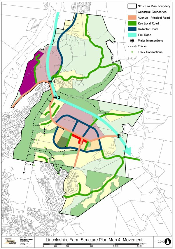 Urban Development Area \ Appendix: Lincolnshire Farm Structure Plan
Operative: 04/05/2021
Urban Development Area \ Appendix: Lincolnshire Farm Structure Plan
Operative: 04/05/2021
Page 31 of 35
eplan.wellington.govt.nz
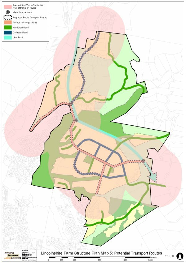 Urban Development Area \ Appendix: Lincolnshire Farm Structure Plan
Operative: 04/05/2021
Urban Development Area \ Appendix: Lincolnshire Farm Structure Plan
Operative: 04/05/2021
Page 32 of 35
eplan.wellington.govt.nz
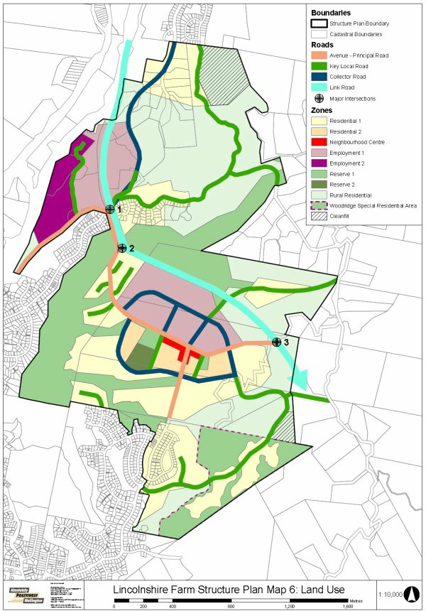 Urban Development Area \ Appendix: Lincolnshire Farm Structure Plan
Operative: 04/05/2021
Urban Development Area \ Appendix: Lincolnshire Farm Structure Plan
Operative: 04/05/2021
Page 33 of 35
eplan.wellington.govt.nz

 Urban Development Area \ Appendix: Lincolnshire Farm Structure Plan
Operative: 04/05/2021
Urban Development Area \ Appendix: Lincolnshire Farm Structure Plan
Operative: 04/05/2021
Page 34 of 35
eplan.wellington.govt.nz
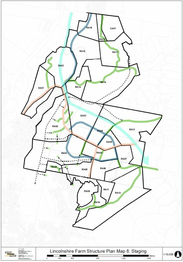 Urban Development Area \ Appendix: Lincolnshire Farm Structure Plan
Operative: 04/05/2021
Urban Development Area \ Appendix: Lincolnshire Farm Structure Plan
Operative: 04/05/2021
Page 35 of 35
eplan.wellington.govt.nz